Nov 072016
 

In a previous post – Mexico’s shoe (footwear) manufacturing industry: regional clustering – we looked at the concentration of the shoe-manufacturing industry in three major areas: León (Guanajuato), Guadalajara (Jalisco) and in/around Mexico City. We have also taken a look at Mexico’s international trade in shoes – Mexico’s footwear industry: imports and exports. We now turn our attention to the distribution of shoe retailers within a large Mexican city.

Shoes in Mexico

The retailing of shoes within cities often exhibits distinctive spatial patterns. Many older and larger Mexican cities tend to have all the retailers for a particular item (furniture, electronics, autoparts, etc) concentrated in a very small area. For example, dozens of retail outlets for electronics are located within a few blocks of Mexico City’s main square or zócalo. Electronics stores are in very close proximity to one other, and occupy both sides of the street for several blocks, leaving little or no room for any other retailers.

Another example of retail specialization is Corregidora street, which has several blocks dedicated to the sale of pots and pans, kitchen utensils and table settings.

Elsewhere in Mexico City’s downtown area:

… turn right and continue down Chile street to the intersection with Tacuba street. One of the most fascinating aspects of commercial life in the downtown area of Mexico City is that each area is specialized in some trade or retail activity. Such trading ghettos were also a feature in Tenochtitlán and the practice still exists today. Where you are now walking is the barrio of bridal shops. The greatest concentration of these shops is north of the Heras y Soto House…” (Candace Siegle, Walking through History, a series of walks through Mexico City’s historic center, 1989)

Returning to the subject of shoes, without which no bridal outfit is complete, shoe retailing is also often heavily concentrated in certain sections of Mexico’s larger cities. Perhaps the most extreme example is in Guadalajara, where shoe retailing is concentrated in two main zones. One of these zones is within the central business district, and is comprised of both regular storefronts and a market. The other area is several kilometers west of the center, around Galería del Calzado, a shopping plaza of more than 60 stores entirely dedicated to shoes. The Galería, located where Yaquis meets Avenida México, has a total floor space in excess of 8,600 square meters (92,500 square ft). The shops in Galería del Calzado stock every major brand and type of shoe, and eagerly compete for your pesos.

From a consumer’s perspective, this is all highly convenient and allows for easy comparison shopping. However, I have never been convinced of the advantages of such concentration from the point of view of the retail store owners, unless perhaps they get their stock from a relatively limited number of (shared) shoe distributors?

Despite the success of many Mexican shoe manufacturers, one of the fundamental weaknesses of the supply chain for footwear in Mexico (according to sector analysts) is the absence of any strong specialized marketer dedicated to shoes. Fancy a job marketing cowboy boots, anyone?

Related posts:

Chapters 21 and 22 of Geo-Mexico: the geography and dynamics of modern Mexico analyze Mexico’s 500-year transition to an urban society and the internal geography of Mexico’s cities. Chapter 23 looks at urban issues, problems and trends. Buy your copy of this invaluable reference guide today!

Basalt columns and prisms can be seen in various places in Mexico

 Other  Comments Off on Basalt columns and prisms can be seen in various places in Mexico
Oct 252016
 

Basalt is a dark, fine-grained, basic (low silica) igneous rock, often extruded as molten lava from volcanic fissures. Its low silica content means it can flow easily, often building up over the years to form large plateaus. As the basaltic lava cools, it contracts and solidifies. An extensive network of cracks often develop in basalt, which may extend many meters deep. These cracks tend to leave columns between them which are roughly hexagonal (6-sided) in shape. Among the more famous examples of basalt columns or pavements in the world are Giant’s Causeway (Northern Ireland), Fingal’s Cave (Scotland) and Devil’s Postpile (California, USA).

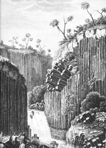
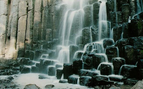
The best known location in Mexico to see basalt columns is about an hour’s drive north of Mexico City, at Santa María Regla, in the state of Hidalgo. These columns, attractively located on the side of a canyon, with a waterfall tumbling over some of them (see sketch), were visited by the famous Prussian scientist/geographer Alexander von Humboldt, during his exploration of Mexico in 1803-04. Some individual columns are 40 meters tall.

Basalt prisms at San Miguel Regla

Basalt prisms at San Miguel Regla, from Humboldt and Bonpland, Vues des Cordilleres et monumens des peuples indigenes de l’Amerique.

The basalt columns of Santa María Regla are one of the locations described in The first geography fieldtrip guide in Mexico. They are also one of Mexico’s top 13 natural wonders.

Basalt prisms at Santa María Regla

Other locations in Mexico where basalt columns or prisms can be seen include a quarry between the towns of Jamay and Ocotlán (Jalisco), the south-facing slope of the hills overlooking the town of Chapala (Jalisco) and the Salto (waterfall) de San Antón (Cuernavaca, Morelos).

Mexico’s geology and landforms are analyzed in chapters 2 and 3 of Geo-Mexico: the geography and dynamics of modern Mexico.  Buy your copy of this book today!
The deepest water-filled sinkhole in the world is in Tamaulipas, Mexico

 Other  Comments Off on The deepest water-filled sinkhole in the world is in Tamaulipas, Mexico
Oct 122016
 

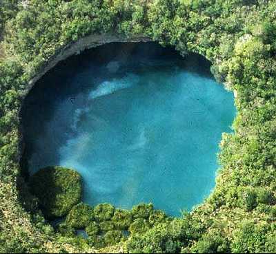
As vertical shafts go, this is a seriously deep one! Long considered to be “bottomless” (because no-one had ever managed to find the floor), we now know it is precisely 335 meters (1099 feet) deep, making it the deepest water-filled sinkhole anywhere on the planet.

The El Zacatón sinkhole is on El Rancho Azufrosa, near the town of Aldama in Tamaulipas in northeast Mexico. The sinkhole or cenote is one of several located in the same area, though recent studies have failed to demonstrate any obvious underground connections between them. The term cenote is a Spanish rendering of the Mayan word d’zonot, “a hole in the ground”. The El Zacatón pit, which is about 110 meters (360 feet) across and roughly circular, contains a deep lake. The water is warm (averaging about 30 degrees C), highly mineralized and has a sulfurous odor. The name El Zacatón comes from the floating islands of grass (zacate) which blow across this lake from one side to the other with the wind.

The Zacatón Sinkhole

The Zacatón Sinkhole

The pit’s depth has attracted serious divers for many years. In 1993, Dr. Ann Kristovich dove to a new women’s world record depth of 169 meters (554 feet). The following year, two American explorers tried to reach the bottom of the sinkhole. Jim Bowden successfully reached a men’s world record depth of 282 meters (925 feet) but still did not touch the bottom. Tragically, his diving partner Sheck Exley died during the attempt.

The mystery of the sinkhole’s depth was finally solved in 2007. A multi-million dollar exploration, mainly funded by NASA, trialled the Deep Phreatic Thermal Explorer (DEPTHX) robot, designed to explore ice-covered Europa, Jupiter’s smallest moon. Partners on the DEPTHX project include Carnegie Mellon University, Southwest Research Institute, Colorado School of Mines, The University of Arizona, and the University of Texas at Austin’s Jackson School of Geosciences. In the words of a NASA press release, The Deep Phreatic Thermal Explorer (DEPTHX) is a 3,300-pound, computerized, underwater vehicle that makes its own decisions. With more than 100 sensors, 36 onboard computers, and 16 thrusters and actuators, it decides where to swim, which samples to collect, and how to get home.

Exploring El Zacatón pit was considered to be an ideal preliminary test of the DEPTHX autonomous robot, which is about the size of a go-kart. The robotic vehicle successfully generated a highly detailed sonar map of the sinkhole, and obtained samples of water and biotic material from the walls, discovering several new phyla of bacteria in the process. Its next challenge is to explore beneath the ice of West Lake Bonney in Antarctica.

At El Zacatón, the sonar study showed that the sinkhole has a total depth of 335 meters: the lake is 319 meters deep at its deepest point, and its surface is 16 meters below the height of the sinkhole’s rim.

Related post:

Sources / Further reading:

Mexico’s geology and landforms are analyzed in chapters 2 and 3 of Geo-Mexico: the geography and dynamics of modern Mexico.  Buy your copy of this book today!
Oct 062016
 

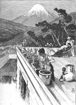
El Pico de Orizaba, or Citlaltépetl (= “star”), is Mexico’s highest peak, rising to a summit 5,610 meters (18,406 feet) above sea level. The third highest peak in North America, it is also that region’s highest volcano, responsible for major eruptions in 1569, 1613 and 1687. The mountain was first explored by scientists as long ago as 1838.

Located east of Mexico City, some 30 kilometers (20 miles) northwest of the city of Orizaba, it is regularly climbed today by well-equipped groups, especially during the dry season, from December to April. Its classical cone shape masks an impressively large crater, which is more than 300 meters (1,000 feet) deep. The volcano and surrounding area were declared a national park by President Lázaro Cárdenas in 1936; the decree took effect the following January.

Among the first recorded ascents is that in August 1838 by a group of several European botanists: Henri Galeotti, Nicolas Funck, Auguste Ghiesbreght and Jean-Jules Linden.  The group spent eleven days on the volcano and their subsequent accounts of the expedition show that they definitely reached the summit. Afterwards, they went on to have distinguished careers in their specialist fields.

By the time of the climb, Henri Guillaume Galeotti (1814-1858) had already written a landmark article about Lake Chapala, and made numerous botanical discoveries in Mexico. He went on to become Director of the Royal Botanical Gardens in Brussels, Belgium.

Less is known about the achievements of Nicolas Funck (1816-1896), who continued traveling in Mexico until 1842. He subsequently became director of Brussels Zoo (1861) and then Cologne Zoo.

After the climb, Auguste Ghiesbreght (1810-1893) set up his own business in Mexico, making a living by supplying plants and natural history specimens to European collectors and his botanist business partners. Who knows? Perhaps the plans for a cacti-exporting business (Galeotti) and large-scale orchid cultivation (Linden) were hatched while the group of young friends were battling their way towards the peak of Orizaba.

Jean Jules Linden (1817-1898), born in Luxembourg, collected for the Belgian government in Brazil, Mexico and Guatemala, before becoming one of the world’s most celebrated importers of plants. He set up nurseries for exotic plants in Brussels and Ghent in Belgium, as well as on the French Mediterranean coast. He also directed Brussels Zoo. He is credited with introducing and popularizing numerous plants, including begonias, palm trees and orchids. His superb publications on orchids and his marketing skills won him world-wide respect.

The nineteenth century craze for orchids in Belgium had numerous parallels with the craze three hundred years earlier for tulips in the Netherlands. The nouveau-riche industrialists satisfied their passion for expensive and unusual orchids by buying them from Linden who was propagating and growing them in massive, industrial-scale glasshouses. Even the Russian czar bought orchids from Linden!

El Pico de Orizaba (from Oswald’s Summerland Sketches, 1880)

The explorations of Galeotti and his friends resulted in the volcano becoming much better known. A decade later, Carl Sartorius, an artist of German extraction who collected plants for the Berlin Botanical Gardens, and who owned the El Mirador hacienda close to the volcano, organized an expedition to reach the summit. When they reached the top, they found a simple plaque there already, left by two US soldiers, F. Maynard and G. Reynolds, who had served as troopers in Winfield Scott’s army during the 1846-1848 Mexican-American war.

Not surprisingly, the upper reaches of El Pico de Orizaba (above about 4,000 meters) are snow-capped all year. Though someone had probably skied down the mountain previously, the first recorded descent on skis was made by W. Furlinger in 1974. Schemes to open a skiing resort on its slopes have been suggested several times. Before any budding entrepreneurs get carried away with the possibilities, it should be pointed out that setting up permanent ski runs on the slopes of El Citlaltépetl may not be too smart an idea, given the likely impact of global warming.

This is an edited and updated version of an article originally published on MexConnect.

Acknowledgment

My thanks to Dr. Winston Crausaz. the author of Pico de Orizaba or Citlaltepetl (Geopress International, 1993), whose valuable comment on the original post (see below) has now been incorporated into the updated version above.

Mexico’s volcanoes, mountains and relief features are examined  in chapters 2 and 3 of Geo-Mexico: the geography and dynamics of modern Mexico.

Alexander von Humboldt’s visit to Mexico, 1803-1804

 Other  Comments Off on Alexander von Humboldt’s visit to Mexico, 1803-1804
Sep 292016
 

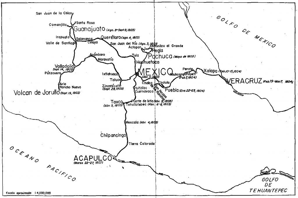
Alexander von Humboldt‘s visit to Mexico began in Acapulco on March 22, 1803, and lasted for almost a year. (He left Mexico via Veracruz for the USA on March 7, 1804.) In his year in Mexico, Humboldt had been incredibly busy. He had measured, recorded, observed and written about anything and everything, with remarkable industry and accuracy. He had climbed mountains, burned his boots on active volcanoes, descended into mines, recorded geographical coordinates, and collected numerous specimens and antiquities. Humboldt’s Political Essay on the Kingdom of New Spain was the first systematic scientific description of the New World. It appeared in 1811, and marked the birth of modern geography in Mexico. His figures and ideas were used and quoted by writers for many many years.

Humboldt had also drawn a large number of maps, drawings and sketches and it can rightly be claimed that the modern era of Mexican map-making began with Alexander von Humboldt, and was then developed further later in the 19th century by cartographers such as Antonio García Cubas.

Humboldt's route in Mexico

Humboldt’s route in Mexico. Click to enlarge

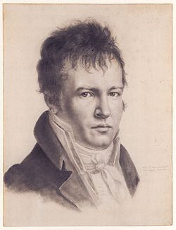
Alexander von Humboldt (Self-portrait c1814)

Alexander von Humboldt (Self-portrait c1814)

The map above shows the route followed by Humboldt during his time in Mexico. The map comes from the book La obra de Alexander von Humboldt en México by Rayfred Lionel Stevens-Middleton  (Mexico D.F.: Instituto Panamericano de Geografía e Historía, 1956). This hard-to-find work is a comprehensive account of Humboldt’s time in Mexico and of his significance for the development of what the author refers to as “modern geography”.

The map of Humboldt’s route in Mexico includes his various side trips such as those to Jorullo Volcano and Santa María Regla.

Humboldt was keen to see Jorullo Volcano, since it was a rare example of a brand new volcano, one of only a handful of volcanoes that have emerged on land anywhere in the world in historic times. Jorullo first erupted on 29 September 1759 and activity continued for 15 years until 1774. Two centuries later, and about 80 km (50 miles) away, Paricutín Volcano burst into action for the first time, in a farmer’s field in 1943.

Santa María Regla, in the state of Hidalgo, about an hour’s drive north of Mexico City, is the best known location in Mexico for basalt columns. The columns, up to 40 meters tall,  are attractively located on the side of a canyon, with a waterfall tumbling over some of them:

Despite only seeing a relatively small part of the country (New Spain as it then was), Humboldt was able to make some generalizations about geography in general, and Mexican geography in particular, that have stood the test of time remarkably well. For example, he was the first to describe the vertical differentiation of climatic and vegetation zones in Mexico. Writing in 1811, he proposed the terms tierra caliente, tierra templada, and tierra fría, terms still widely used by non-specialists today:

Related posts:

Note: this post was first published on May 7, 2012.

Sep 262016
 

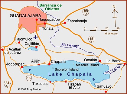
Lake Chapala is Mexico’s largest natural lake. On the geological timescale of millions of years, all lakes are temporary features on the earth’s surface. Once formed, natural processes begin to fill them in and/or to drain them.

Map of Lake Chapala, Jalisco, Mexico. All rights reserved.

Lake Chapala resulted from drastic earth movements, accompanied by earthquakes and faulting which occurred some twelve million years ago. Lake Chapala collected on the floor of a rift valley. Movements along the parallel systems of faults that caused the rift valley still occur today. Evidence for this continued movement can be seen in the cracked or displaced walls of some local buildings.

Given its advanced age, it is not surprising to discover that Lake Chapala was once (thousands of years ago) much larger. In fact, though no-one has so far proven it beyond doubt, it may have been immensely large, covering an area seven times its present area, with a correspondingly long shoreline. At a later stage in its history, it became the deepest lake of an interconnected series of lakes which flooded the valley floors where the towns of Jocotepec, Zapotitan, Zacoalco and Sayula are today. The present Lake Chapala is thus probably only a small remnant of the original version.

The lake is under heavier pressure than at any time in its existence. Local towns and the nearby city of Guadalajara see it as an inexhaustible supply of domestic and industrial water. Tourists see it as a recreation resource, and the thousands of foreign retirees who have settled on its shores see it as a major reason for the area’s beneficial climate.

A case study of ‘residential tourism’ in the villages on the northern shore of Lake Chapala is discussed in chapter19 of Geo-Mexico: the geography and dynamics of modern Mexico.

The levels of flow of the River Lerma, the only river of any size entering the lake, are crucial to the health of the lake. In recent years, demands for Lerma water have multiplied many times over, principally for farms in neighboring states, but also for industries. All the other rivers entering the lake are much smaller and, with rare exception, flow into the lake only a few times a year during the rainy season. The hydrology of Lake Chapala is discussed in chapters 6 and 7 of Geo-Mexico: the geography and dynamics of modern Mexico.

The good news is that Lake Chapala was recently declared an Internationally Important Wetland by the Ramsar Convention, joining a large global network of similarly important wetland sites. The 13th International Living Lakes Conference was held in Chapala, March 22-25, 2010.

This is an edited excerpt from Tony Burton’s Western Mexico, A Traveller’s Treasury (4th edition) .

Sep 192016
 

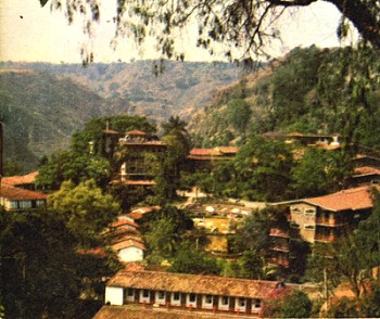
In its day, the San José Purua spa-hotel in Michoacán was world-famous. Opened in the early 1940s, it was the epitome of luxury living. European chefs cooked for the guests. Cabaret and touring acts from all over the world performed in its small night club. An on-site bowling alley provided some entertainment for the younger set. The hotel’s popularity led to the access road, complete with its “La Curva de la Gringa“, being paved for the first time in the mid 1940s. One writer mentions that he saw cars with license plates from no fewer than eight different countries in the hotel’s car park—all at the same time!

San José Purua spa hotel (from an early brochure)

Guidebooks of the time all extolled its virtues, and its peculiarities. For example, this is how Sydney Clark, in “Mexico Magnetic Southland” (1944), described the hotel:

“The hotel, designed in a curious arc with a high bridge leading to the comedor (dining room) is located on a narrow shelf of land on the side of the extremely deep gorge of the Tuxpan River. To beautify the setting, and also for utilitarian reasons, the management has planted no less than fifteen thousand orange trees on the gorge-side, and along with these some coffee trees. There are two large swimming pools with warm radioactive water gushing into them all the time directly from the cliff. It oxidizes in the open air within a few minutes and turns to an odd café au lait color so that the pool is always brown. However, it is no whit less clean than any spring fresh from the earth, and the curative properties are said to be extremely potent.”

Sadly, the San José Purua hotel ran into ownership and management problems and is now but a poor shadow of its former self, though the grounds and pools can still be admired. Several attempts have been made to relaunch the hotel as a luxury resort, but so far none has succeeded.

If you want to overnight or vacation in this magnificent part of Mexico, the best place by far is slightly further down the valley, at the Agua Blanca Canyon Resort, a charming, small hotel with just 20 rooms set in stunning scenery, with its lawns overlooking the deeply carved valley of the River Tuxpan.

This is a geographer’s delight! Waterfalls, rock formations, the meanders of the Tuxpan River, steep canyon slopes… what more could one want? This was one of the first locations in Mexico where high school students were actively engaged in geography fieldwork investigations thirty years ago.

In February 2010, a short distance upstream, the Tuxpan River burst its banks flooding the town of Tuxpan and other nearby settlements in Michoacán.

This is also the region where director John Huston filmed parts of “The Treasure of the Sierra Madre“, starring Humphrey Bogart, in 1947 (he used the San José Purua hotel as his base), but that’s a whole other story.

Sep 142016
 

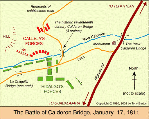
The battle in question is the Battle of Calderón Bridge (Batalla del Puente de Calderón), fought just outside Guadalajara in January 1811 as part of Mexico’s fight for Independence. The decisive battle was waged on the morning of Thursday, January 17.

On one side was Ignacio Allende with some 80,000 ill-equipped and untrained supporters of Father Miguel Hidalgo, the priest who launched Mexico on the road to Independence. On the other side was the numerically much smaller, but professional, Royalist army led by General Félix María Calleja, fighting for the King of Spain .

After six hours of fighting, a stray grenade from the Royalist side landed smack in the middle of the insurgents’ ammunition supplies, resulting in a fearful explosion and fire which brought the battle to a speedy end. Hidalgo and his men fled northwards; the crown troops followed, hot on their heels. The loss of this battle effectively dashed hopes of any quick independence from Spain. Mexico’s  Independence was delayed another ten years, until 1821.

The area where this important battle took place is between Guadalajara and Tepatitla, in the state of Jalisco. A few kilometers beyond Zapotlanejo, the site is clearly marked by a large monument to Father Hidalgo, prompting one to reflect on how often the losers of a battle are commemorated, rather than the winners. The statue overlooks the battlefield: the shallow valley of the Calderón river. In Hidalgo’s time, only a single bridge spanned the river. It was made a national monument in 1932.

Today, three different bridges exist in the general vicinity of the battle and a fourth, not far away, is used by the toll highway to Lagos de Moreno. It’s easy to tell which of the four bridges is the correct one, since it has a plaque commemorating the event!

Curiously, the historically-accepted plan of the battle, reproduced in dozens of scholarly works and hung on display in many museums around the country (still including, to the best of my knowledge, the Regional Museum in Guadalajara) is in fact, upside down! The true orientation of the map was proven (way beyond any reasonable doubt) by Mexican geographer Alma Rosa Bárcenas. In a brilliant and clearly written article, which appeared in the first isue of “Geografía”, published by INEGI in Mexico City in 1986, she clears up the confusion surrounding the exact site of the battle.

She proves, using both field-work and aerial photographs to supplement contemporary battle descriptions which give clues to terrain, slopes and visibility, that the map was drawn “south-upwards”. The map’s “north arrow” actually points due south!

Here is the battle plan the right way round. At last, the battle descriptions make sense! Now, anyone visiting the battle site has a chance to work out for themselves the true dispositions of the troops on both sides, and relive, if only in their imagination, the course of this key battle in Mexico’s War of Independence…

This is an edited version of an article originally published on MexConnect. Click here for the original article

Geo-Mexico: the geography and dynamics of modern Mexico takes an in-depth look at the implications of Mexico’s 1810-1821 War of Independence for the development of transportation and communications systems, as well as migration patterns, settlements and many other aspects of Mexico’s geography and development.

As an added bonus, it has no maps that are upside-down!

Novelist who loved geography set a story in Mexico, which his publisher labeled South America

 Other  Comments Off on Novelist who loved geography set a story in Mexico, which his publisher labeled South America
Sep 082016
 

Several famous writers wrote about Mexico despite having no direct geographic experience of the country.

One of the most famous was  Jules Verne. Verne (1828-1905) popularized geography and was one of the pioneers of travel stories and science fiction.

Many his works have undeniably strong connections to geography, including:

  • Twenty Thousand Leagues Under the Sea, a submarine voyage with Captain Nemo as the enigmatic hero
  • A Journey to the Center of the Earth, in which Prof Lidenbrock and his nephew Axel descend into an extinct volcano in Iceland and discover an underground world
  • From the Earth to the Moon, a vivid forerunner of future space travel
  • Around the World in Eighty Days, where eccentric Englishman Phileas Fogg races round the world to try and win a bet
  • Five Weeks in a Balloon, in which the heroes drift across unexplored areas in Central Asia and The Mysterious Island

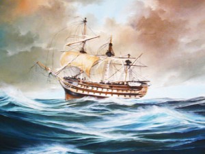
Curiously, one of Verne’s first published stories, was set in Mexico, despite the fact that he had never visited the country. The original title Verne gave the story was North America. Historical studies. The first ships of the Mexican Navy. Meticulous as he was in regards to his geography, Verne was understandably aggrieved when the publisher changed North America to South America without even asking him! The story was first published in 1851, and later reworked as A Drama in Mexico.

The Asia; oil on canvas

The Asia; oil on canvas by Angel Cortellini Sánchez, dated 1896

The plot is set in 1825, shortly after Mexican Independence from Spain (1821). Mexico needed a strong navy to protect its extensive territory, which then stretched as far south as present-day Costa Rica. Antonio de Medina, the first Secretary of War & Navy, had fought at the Battle of Trafalgar in 1805. He persuaded the Mexican Congress to give high priority to the formation of a navy. Foreign interventions later in the century showed how prescient de Medina had been.

Verne’s story tells how the Mexican Navy obtained its first two warships, the former Spanish vessels Asia (later renamed the Congreso Mexicano) and Constanzia, following a mutiny by their crews.

The locales used in the story include:

  • four Pacific coast ports: Acapulco, San Blas, Zacatula and Tehuantepec
  • the villages or towns of Cigualan [Cihuatlán], Chilpanzingo [Chilpancingo], Tasco [Taxco] and Cuernavaca,
  • the caverns of Cacahuimilchan [Cacahuamilpa]
  • the pre-Hispanic site of Xochicalco
  • Popocatepelt [Popocatepetl] Volcano

Read the original: Complete 1876 text in French as a webpage or Alternative complete text in French

If he had never visited Mexico, how did Verne acquire the range of geographic knowledge displayed in this story? Like many other geographers before and after, he relied on qualitative fieldwork—gaining his knowledge by talking to seafarers in his native port of Nantes, and through conversations with Jacques Arago, a Parisian friend who had fought in Mexico’s War of Independence.

Verne’s failure to visit Mexico certainly did not mean that his works had no significance to the people there. Indeed, as social historian William H. Beezley reminds us:

“His novel Around the World in 80 Days, published in 1873, had great popularity in Mexico, where many writers made comparisons between the characters in the novel and the nation’s first international scientific expedition in 1874 that also circumnavigated the globe…”   Mexican National Identity: memory, innuendo and popular culture).

The main purpose of Mexico’s first international scientific expedition in 1874 was to observe, from Japan, the transit of Venus across the Sun.

Verne became the most widely read French author of all time, and one of the most translated authors anywhere in the world.

And what became of the Mexican Navy?

Today, the Mexican Navy (Secretaría de Marina) has over 55,500 personnel, 300 ships and 70 aircraft. Its main tasks are to protect oil reserves in the Gulf of Mexico, assist in the fight against drug traffickers, and aid in hurricane relief efforts.

Original article as it appeared on MexConnect

Mexico City declares public markets to be Intangible Cultural Heritage

 Other  Comments Off on Mexico City declares public markets to be Intangible Cultural Heritage
Aug 222016
 

Mexico has some of the finest markets in the world. The variety of produce and other items sold in markets is staggering. But not all Mexican markets are the same. The two major groups are the permanent markets (mercados), usually housed in a purpose-built structure and open for business every day, and the street market or tianguis, usually held once a week.

Earlier this month, Mexico City passed legislation that gave the city’s 329 public markets Intangible Cultural Heritage status, and provided additional funding to ensure that their traditional activities are maintained for future generations.

Some of the markets are traditional, mixed markets, others are specialized. Between them, they are used on a regular basis by almost half of Mexico City’s residents and provide more than 280,000 jobs. The Mexico City commission established to preserve these traditional spaces and their practices has been allocated a budget in 2017 of $200,000,000 pesos (about $11 million).

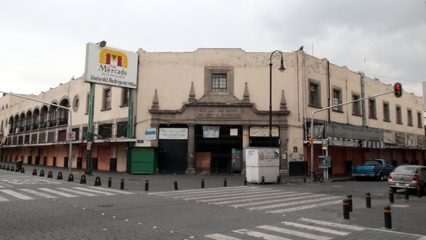
Abelardo L. Rodriguez Market. Credit: Wikimedia. Creative Commons.

Abelardo L. Rodriguez Market. Credit: Wikimedia. Creative Commons.

Beyond their regular role as a trading place, many of the markets in Mexico City have additional claims to fame. For example the La Paz market in Tlalpan in the southern part of the city occupies an architecturally impressive building, while the Abelardo L. Rodríguez market in the downtown area has fine decorative murals painted by students of Diego Rivera.

Related posts:

Aug 182016
 

Despite having seen this tourist promotion logo thousands of times, I had never thought about its colors and their significance until recently.

mexico tourism logoIt turns out that the colors (despite what you may see on your monitor) are actually meant to be:

  • M – brown = archaeology and archaeological sites (historical tourism)
  • é – pink = health and well-being (including medical tourism)
  • x – yellow = culture (cultural tourism)
  • i – purple = meetings (seminars and conference tourism)
  • c – green = nature (adventure tourism and ecotourism)
  • o – blue = sea, sun and sand (beach and resort tourism)

The federal Tourism Secretariat is planning a nationwide overhaul of tourism signage on major highways taking advantage of these colors. It will install new, standardized signs using these six colors as a quick means of identifying the kind of tourist attraction at each location of interest. The program has funding of almost $10 million, and the first states to have the new signs will be Chiapas, Durango, Guanajuato, Hidalgo, Jalisco, Michoacán, Puebla, Tabasco, Tlaxcala and Veracruz.

Whether or not using six different colors is actually more effective than six distinct symbols on the same color background remains to be seen.

In the first half of this year, Mexico received 17,000,000 international tourists, 8.6% more than for the corresponding period in 2015, with expenditures by tourists rising 8% to $10.063 billion.

Related posts:

Index page: Mexico’s indigenous peoples

 Index page, Other  Comments Off on Index page: Mexico’s indigenous peoples
Aug 042016
 

As the site continues to grow, in content and readership, we are adding the occasional index page to help new readers find articles of interest. According to the 2010 census, 6,000,000 Mexicans over the age of five speak at least one indigenous language. Another 3,000,000 Mexicans consider themselves indigenous but no longer speak any indigenous language.

General

Specific groups

Maya

Aztec / Mexica

Tohono O’odham

Huichol

Tarahumara

Other Geo-Mexico index pages:

23 July: Happy Geographers’ Day! – ¡Feliz Día del Geógrafo de México!

 Other  Comments Off on 23 July: Happy Geographers’ Day! – ¡Feliz Día del Geógrafo de México!
Jul 232016
 

Today, 23 July, is Día del Geógrafo de México or Mexican Geographers’ Day. See this earlier post for a brief history of why 23 July came to be chosen.

The community of geographers in Mexico has always been strong, and geographers are held in higher esteem in Mexico than in most countries. Online, for those speaking Spanish, the Facebook page of 23 de Julio: día del Geógrafo de México regularly has interesting links to publications, cartoons, photos and other resources.

One of my recent favorites is this great scenic landscape image from the Facebook page of Los Gastronautas:

Los Gastronautas: Landscape of ham and parsely

Los Gastronautas: Landscape of ham and parsley

Geography is everywhere! A Happy Mexican Geographers’ Day to all geographers, whether in Mexico or elsewhere.

Acapulco’s ACAbus system finally begins operations

 Other  Comments Off on Acapulco’s ACAbus system finally begins operations
Jun 162016
 

On 21 June, the public transit system known as ACAbús will finally officially begin operations in the resort city of Acapulco in Guerrero. ACAbús began trial operations on 31 May, following several years of delays.

acabus

The service employs 135 Dina buses of various kinds, all equipped with state-of-the-art technology to reduce emissions, save fuel and will substitute 366 old, less efficient vehicles to the benefit of both locals and tourists.

The system represents an investment of around $140 million, roughly two-thirds for highway and transit stop refurbishment and one-third for operating equipment (vehicles and travel card machines).

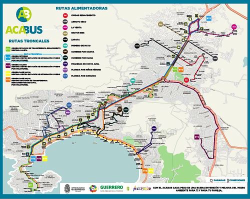
ACAbús connects the resort’s many tourism attractions and facilities. The main central axis (map) is a 16-km (10 mile) long route from Las Cruces along Avenida Cuauhtémoc to Caleta, with 18 stops along the way. This portion will be confined solely to rapid transit articulated buses.

Map of ACAbús network; click forlarger pdf map

Map of ACAbús network; click for larger pdf map

Four trunk routes supplement this central axis, each with a limited number of stops. The ones of interest to most tourists will be Routes 4 and 5, which run along the main Costera Miguel Alemán highway. A series of shorter feeder routes provides easy access from most parts of the city to the nearest trunk route.

Passengers are required to obtain a pre-paid card in order to use the system. Most journeys, including connecting service, will cost $10 pesos (less than 60 cents U.S.).

The number of different bus routes in Acapulco has been reduced from about 220 to 120, but travel times should be greatly improved. Authorities claim that the system should cut regular traffic by about 25%, and that everyone will benefit as it means that older vehicles have been removed from the roads with a decrease in total emissions.

Related posts:

How was Playa Escondida (“Hidden Beach”) formed?

 Other  Comments Off on How was Playa Escondida (“Hidden Beach”) formed?
Jun 022016
 

Following on from our look at the potentially disastrous environmental consequences of publicizing Playa Escondida (“Hidden Beach”), one of Mexico’s most beautiful small beaches, we take a look at how this extraordinary beach was formed.

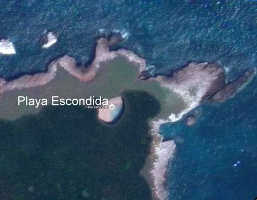
Playa Escondida. Source: Google Earth. Scale: The beach is about 30 m (100 ft) long.

Playa Escondida. Source: Google Earth. Scale: The beach is about 30 m (100 ft) long.

Playa Escondida is on one of the small, uninhabited Marieta Islands, in the Marieta Islands National Park, off the west coast of Mexico, and relatively close to Puerto Vallarta.

playa-escondida

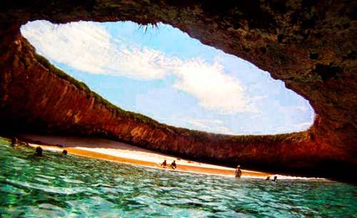
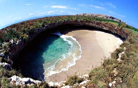
The beach is an “eye to the sky” and is aptly described by travel writer Brandon Presser, as follows:

At the center of Isla Redonda [is] a quirk of nature seen only on the pages of a fantasy novel—a sandy beach carved into the rounded core of the island like the hole of donut. Although completely invisible from the shoreline, a bird’s eye view reveals lapping crystal waters and an empty dune like dazzling colors at the end of kaleidoscope’s funnel.”

The Marieta Islands are formed of volcanic rocks and are an extension of Mexico’s Volcanic Axis.

Just how was this beach formed? Prosser describes two alternative suggestions. The first is that the volcanic rocks were not uniform in composition and hardness but had differences in resistance to subaerial weathering and erosion. According to this theory, the weaker, less consolidated rocks were eroded more quickly than the surrounding rocks to leave a giant chasm in the ground. This chasm was then breached on one side by marine action.

The alternative theory mentioned by Prosser, and the only one mentioned (though without citation) by wikipedia, is that the chasm was formed by human activity, specifically by the Mexican military who undertook bombing practice in and around the islands prior to when the area was given National Park status.

Coastal geomorphologists might argue the case for considering a third theory, involving the formation, first, of the cove on the outer coast of the island, followed by a combination of marine and subaerial action to exploit a line of weakness in the volcanic rocks to create a landform known as a geo (a narrow, deep, cleft extending inland from the coast). This geo may have gradually lengthened over time, by continued cave formation at the head of the geo, with marine erosion at the back of the cave opening up a blowhole, a small opening to the sky. A sequence of collapses and blowhole formation, over time, may have created Playa Escondida, where the interior beach is the base of a former blowhole, where the roof has collapsed and the material subsequently removed by marine action or pounded into beach sand.

Whatever the explanation, this particular geomorphosite is one of Mexico’s many natural treasures, and one well worth preserving for future generations.

Related posts

Novelist Charles Fleming Embree, an honorary geographer

 Other  Comments Off on Novelist Charles Fleming Embree, an honorary geographer
May 302016
 

American author Charles Fleming Embree‘s A dream of a throne, the story of a Mexican revolt, published in 1900, is, I believe, the earliest novel in any language about the Lake Chapala area. It is an historical novel, set in the area during the nineteenth century, but Embree reveals an extraordinary depth of knowledge, not only of the history of this area, but also of its geography.

Embree was only 24 years of age when he and his wife Virginia, newly-weds at the time, arrived in Chapala in 1898. Embree had dropped out of Wabash College in his native Indiana, without completing his degree, to devote himself to his writing and his first book, a collections of stories entitled For the Love of Tonita, and other tales of the Mesas (1897) had proved successful.

The Embrees lived in Chapala for eight months in 1898, before traveling to other parts of Mexico, including Guanajauto, Xalapa, Cuernavaca and Oaxaca. Embree’s publishers described A dream of a throne as, “A powerful and highly dramatic romance, dealing with a popular Mexican uprising half a century ago. It is a novel of adventure and of war, and its strongly contrasted characters glow with life and realism. The writer’s thorough knowledge of Mexican life gives him a wealth of new material; and the descriptions of scenery at Lake Chapala are vivid, full of color, and alive with mountain air”.

A Dream of a Throne by Charles F. Embree

A Dream of a Throne by Charles F. Embree

The book is indeed a remarkable achievement. Despite only living at Lake Chapala for a few months, Embree acquired and demonstrates, from a geographical perspective, an extraordinarily accurate and astute knowledge of all his lakeside locales. The spelling of all place-names, with the exception of Ajicjic and Tuxcueco, is exactly as it is today. Details of clothing, habits and customs all ring true. Embree’s knowledge of the region’s nineteenth century history is equally impressive. As one small example, the story begins in the shadow of St. Michael’s hill in Chapala in May 1833, amidst fear of an epidemic of smallpox. In real life, the nearby city of Guadalajara suffered a cholera epidemic in the summer of 1833.

From a human geography perspective, this novel offers us one of the earliest descriptions of everyday indigenous life in the region. As Dr. Wolfgang Vogt of the University of Guadalajara has pointed out, even by the 1920s (twenty years after Embree’s novel), virtually no-one was observing or writing about this area from an indigenous point of view. Embree’s novel has particular value since it examines the conflicts between Indians and Spaniards, anticipating the themes explored by D. H. Lawrence when he visited Chapala for a couple of months in 1923 and penned the first draft of The Plumed Serpent.

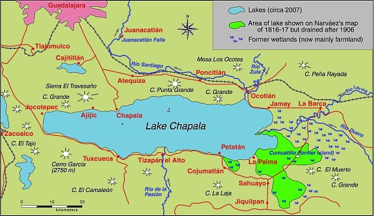
All the action in Embree’s novel takes place on and around Lake Chapala. The major locales are Mezcala Island, Chapala, Ajijic and Tizapan. The following extracts have been chosen to highlight his depictions of the local landscapes. Lake Chapala was significantly larger in 1898 than it is today (see The eastern end of Mexico’s largest lake, Lake Chapala, is amputated):

Lake Chapala, showing area drained at start of 20th century. Map: Tony Burton. All rights reserved.

Lake Chapala, showing area drained at start of 20th century. Map: Tony Burton. All rights reserved.

Here is Embree’s description of Ajijic:

They were riding over a rough trail with cacti and stones about, and here and there a flock of goats. To the right was a seemingly endless chain of mountains, to the left, more distant, rose St. Michael, low and round (behind whose bulk lay Chapala and the water), and the larger head, called Angostura, lying between that town and Ajicjic on the lake’s edge. Between Angostura and the opposite mountain chain the road led, rising to a hill, to whose summit the little army came. They looked down on the lake and, nearer, small irregular fields, scores of them, checkering a level stretch from mountains to water. Out of these, Ajicjic’s church thrust up a single gleaming tower of white. Three o’clock found the troop sweeping into the barren plaza of that fishing village.

To this day Ajicjic can claim no more than some two thousand souls. It has, even yet, no railroad, no stage; rarely has a vehicle been seen in that primitive place other than the awkward oxcart. Its low, unplastered adobe walls stand close together. The streets are alleys of extreme narrowness wherein there is mud when it rains, dust when it is dry, rocks and swine forever. Nigh every alley twists and turns, is for a block no more than a gutter, for another block a public stable for burros. Yet one may find some better quarters. The plaza, though it is only a bare, brown waste, is wide. The open court before the church, though it too is bare and dirty, with lonely, crumbling walls and pillars about it, yet has in its center a weather-beaten cross that speaks of service to the Lord.

The troop filled the plaza. It was halted, and the inhabitants of the town, struck with amazement, either shut themselves up or gathered in silence round about. Groups of brown children, absolutely naked, sat down in the dirt, thumbs in mouth, to wonder in comfort. Rodrigo and Bonavidas began the inquiries, prefacing them with jocularly expressed friendship to certain storekeepers and a toss of tequila here and there down a willing throat. Boats? There hadn’t come but one boat to Ajicjic the blessed day. Ajicjic was losing importance in these times. On market days everybody went to the bigger market at Chapala, where the news was dispersed. And this one boat? It had come from Tizapan with a load of wood for the lime burners.

His landscape descriptions are equally adept:

The town of Tizapan lies at a short distance from the lake. The shore in that region is no such distinctly marked line of beach and rock as it is at Chapala. It is not even always easy to tell where the shore is. Between water and land there is a stretch of marsh for several hundred yards, watery, pierced by the spears of a million reeds that rise thick and green to a height of some feet. Here flock ducks in great numbers. The marsh is flat, bewildering, and dreary. Through its middle a stream, called the Tizapan River, cuts out more than one course, having formed a delta. The main course of this river, not over twenty yards at its widest part, usually much narrower, is navigable for canoas for half a mile to a point where the land is dry and from which the town lies yet another mile distant. The stream being crooked and the curves sharp, the progress from the open lake to the inner landing is usually made by poles. The lake approach to the town could be easily blocked by blocking the river. Only the one course is navigable. Nobody could cross the marshes. This fact was recognized more than a century ago.

The town itself is like the greater part of Mexican towns, narrow and crooked streets with the low houses (joined together) shutting those streets in and making them seem even narrower, and the central plaza of considerable size left vacant. That plaza is today filled with flowers and fruit and contains a bandstand. In former times it was bare. The mountains rise only a little way behind the town, jagged and huge. Before them is a stretch of rolling green fields. The river, coming from the peaks, dashes down through this pastoral scene with a vivacity that has laid bare a rough and rocky bed whereon the water boils till it passes through the town. At the time when the two small armies were approaching Tizapan, much of the summer green was still on field and mountain. The unclouded sun poured his light over an emerald gem of the lake’s border.

After their time in Mexico, the Embrees settled in Santa Ana, California. Embree published his second novel A Heart of Flame: the Story of a Master Passion in 1901, and supplied a steady stream of short stories to major magazines, including McClure’s, the San Francisco Argonaut and Sunset Magazine. Sadly, the couple had not long celebrated the birth of their only daughter Elinor in 1905 when Embree was taken seriously ill. He died on July 3, not yet 31 years old.

It is tragic that someone who had produced work of this magnitude, should have died so terribly young. In his short time in Chapala, Charles Embree had acquired an excellent historical and geographical knowledge of the region at a time when American travelers to the lake were few and far between. Geo-Mexico believes that Charles Fleming Embree fully deserves to be declared an Honorary Geographer.

Note: The post is based on chapter 43 of Lake Chapala through the ages; an anthology of travellers’ tales (Sombrero Books, 2008) and on American novelist Charles Fleming Embree set his first novel at Lake Chapala” (MexConnect, 2009).

Related posts:


The downside to publicizing one of Mexico’s most beautiful beaches

 Mexico's geography in the Press, Other  Comments Off on The downside to publicizing one of Mexico’s most beautiful beaches
May 232016
 

In the past couple of years, Mexico’s federal tourism department has included a truly magnificent beach on some of its publicity posters. It is one of those advertising posters that really catches the eye. I first saw a poster featuring Playa Escondida (“Hidden Beach”) in a departure lounge at Vancouver’s International Airport and spent the next hour watching people’s reactions as they passed it. Several people paused and studied the photo, demonstrating its success in capturing people’s attention.

playa-escondida-tourism-poster-2The beach concerned, also known as the “Beach of Love”) is on one of the small, uninhabited Marieta Islands, in the Marieta Islands National Park, off the west coast of Mexico, and relatively close to Puerto Vallarta.

The posters, and resulting publicity, have led to so many tourists wanting to experience the beach for themselves – more than 2500 visitors a day during Easter Week this year – that Mexico’s National Protected Areas Commission (Conanp) has ordered the beach closed for at least three months due to concerns about environmental damage. Conanp has indicated that the local coral reef has already been adversely impacted by tourism.

Conanp’s decision follows a study by scientists at the University of Guadalajara which concluded that tourism has led to the death of coral, accumulation of garbage, and to pollution from hydrocarbons. The study estimated the beach’s environmental carrying capacity (the number of people that could visit the beach without causing lasting environmental damage) to be 625 visitors a day. Given the secluded nature of this beach, its perceptual carrying capacity (the maximum number of visitors that other visitors can tolerate, based on such impacts as noise) may be even lower.

To assuage some of the economic concerns of tour operators, Conanp is making plans to open a different beach on another of the Marieta Islands for tourism at some point in the near future.

During Easter week, there were numerous press reports that boats ferrying people to the Marieta Islands from El Anclote, Nayarit, were often overcrowded and carrying more passengers than their permits allowed. Boat owners, not surprisingly, deny this, and claim that this is yet another attempt to dislodge them from their remaining toehold on Punta de Mita, where a major upscale tourism development forced many fishermen out of their homes about thirty years ago. For details, see the text accompanying our Map of the Beaches of Jalisco.

islas-marietas-playa-excondida

The number of tourists traveling to Playa Escondida increased from 27,500 in 2012 to 127,372 in 2015. While the federal tourism poster was not the only publicity given the beach, it certainly appears to have played a part in increasing public awareness of this scenic geotourism location, ultimately resulting in the need to make it off limits for tourism, at least for now.

Related posts

We discuss the consequences of tourism, good, bad and neutral, at length, in chapter 19 of Geo-Mexico: the geography and dynamics of modern Mexico. Buy your copy (Print or ebook) today!
May 192016
 

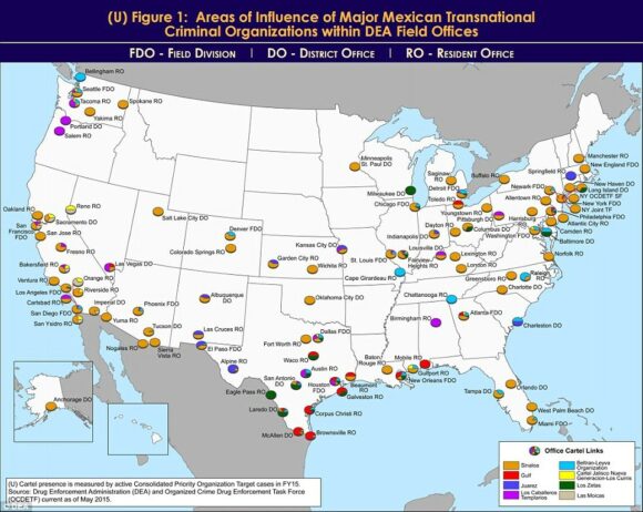
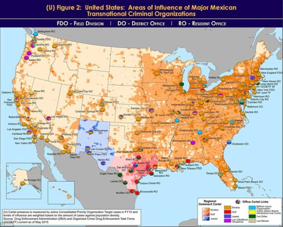
An unclassified DEA Intelligence Report from a year ago has just resurfaced on my desk. Entitled United States: Areas of Influence of Major Mexican Transnational Criminal Organizations, it includes two particularly interesting maps.

The report states that “Mexican transnational criminal organizations (TCOs) pose the greatest criminal drug threat to the United States; no other group is currently positioned to challenge them. These Mexican poly-drug organizations traffic heroin, methamphetamine, cocaine, and marijuana throughout the United States, using established transportation routes and distribution networks. They control drug trafficking across the Southwest Border and are moving to expand their share, particularly in the heroin and methamphetamine markets.”

As of May 2015, the DEA identified the following cartels that operate cells within the USA: the Sinaloa Cartel, Gulf Cartel, Juarez Cartel, Knights Templar (Los Caballeros Templarios or LCT), Beltran-Leyva Organization (BLO), Jalisco New Generation Cartel (Cartel Jalisco Nueva Generacion or CJNG), Los Zetas, and Las Moicas.

The maps reflect “data from the Organized Crime Drug Enforcement Task Force (OCDETF) Consolidated Priority Organization Target (CPOT) program to depict the areas of influence in the United States for major Mexican cartels.”

DEA-Mexican cartel influence in USA

DEA-Mexican cartel influence in USA

Figure 1 (click map to enlarge) shows the distribution of DEA Field Offices. The pie chart for each office shows “the percentage of cases attributed to specific Mexican cartels in an individual DEA office area of responsibility”.

“Since 2014, the Arellano-Felix Organization, LCT, and the Michoacán Family (La Familia Michoacán LFM) cartels have been severely disrupted, which subsequently led to the development of splinter groups, such as, “La Empresa Nueva” (New Business) and “Cartel Independiente de Michoacan” (Independent Cartel of Michoacan) representing the remnants of these organizations.”

Figure 2 (below) shows the dominant transnational criminal organization (TCO) in each domestic DEA Field Division, relative to other active TCOs in the same geographic territory. The map includes population density shading which “is intended to depict potential high density drug markets that TCOs will look to exploit through the street-level drug distribution activities of urban organized crime groups/street gangs.”

DEA-Mexican cartel influence in USA

DEA-Mexican cartel influence in USA

“The Sinaloa Cartel maintains the most significant presence in the United States. They are the dominant TCO along the West Coast, through the Midwest, and into the Northeast. While CJNG’s presence appears limited to the West Coast, it is a cartel of significant concern, as it is quickly becoming one of the most powerful organizations in Mexico, and DEA projects its presence to grow in the United States over the next year. In contrast, Mexican cartels such as the Gulf, Juarez, and Los Zetas hold more significant influence closer to the Southwest Border, but as shown on the map, their operational capacity decreases with distance from the border.”

Other, smaller, “splinter groups from the disrupted LCT organization continue to traffic drugs from the Michoacán, Mexico area into the United States. The BLO, former transportation experts for the Sinaloa Cartel, is most active along the East Coast and is also responsible for the majority of heroin in the DEA Denver area of responsibility. Las Moicas is a Michoacán-based organization with former LFM links, but remains a regional supplier in California and operate on a smaller scale relative to other major Mexican TCOs.”

Related posts:


Apr 252016
 

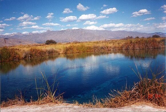
Cuatro Ciénegas (“Four Marshes”) is a city and municipality in the northern border state of Coahuila. Founded in 1800, it has some historical significance, since it was the birthplace of Venustiano Carranza, Mexico’s president from 1915 to 1920.

The natural nearby “marshes” are highly unusual. Situated in an arid region (part of the Chihuahuan desert), they include several natural springs that feed more than 200 small ponds and wetlands. Some of the water supporting these unique wetlands, which cover an area of 84,400 hectares, is believed to be more than 200 million years old. The wetlands are an integral part of the UNESCO-designated Cuatro Ciénegas biosphere reserve. The reserve is home to several endemic organisms, including microorganisms such as cyanobacteria that historically helped produce oxygen for the Earth’s atmosphere. The area is considered “a living laboratory of evolution and the origin of life”.

Cuatro Ciénegas. Credit: Nancy T. Wilson (MexConnect)

Cuatro Ciénegas. Credit: Nancy T. Wilson (MexConnect.com)

Human activities in the surrounding area have led to severe water stress on the Cuatro Ciénegas marshes. The basin’s average natural recharge rate (replenishment rate) is about  25 million cubic meters a year, but the average yearly extraction rate, almost all for agricultural use, is close to 49 million cubic meters.

Water stress may be exacerbated in coming years by climate change, which may reduce rainfall while simultaneously increasing evapotranspiration.

Scientists have also identified five particular exotic (introduced) species that pose a significant risk to the long-term quality of the Cuatro Ciénegas wetlands. Whether naturally or deliberately introduced, these five species – African jewelfish, blue tilapia, giant cane (giant reed), Guatemalan fir and tamarisk (salt cedar) – threaten to displace endemic species and change natural nutrient flows and food chains. Guatemalan fir and tamarisk soak up water as they grow, further drying out the marshes (though, eventually, when little water is left, they will die off). The blue tilapia carries parasites that can jump to local species that have no resistance to them. The African jewelfish occupies the same ecological niche as the endemic mojarra and gradually replaces it.

Mexico’s Comision Nacional de Áreas Naturales Protegidas (CONAMP), is now working with the Mexican Fund for Nature Conservation (FNCN) and the Canadian government agency Parks Canada to develop and implement a control and eradication program to tackle these five invasive species. The long-term survival of this highly unusual ecosystem may well depend on this program’s success.

Related posts:

The world’s first ecological museum was designed and built in Mexico

 Other  Comments Off on The world’s first ecological museum was designed and built in Mexico
Apr 042016
 

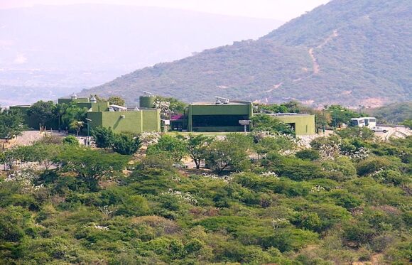
The world’s first ecological museum was designed and built in Mexico, at the archaeological site of Xochicalco, in the state of Morelos. The museum, about thirty kilometers south of Cuernavaca, was built as part of Mexico’s celebrations to commemorate the 500th anniversary of the voyage of Christopher Columbus.

The project, which overs 12,676 square meters, was begun in 1993. Basic construction was completed in 1994 and the museum was formally inaugurated in April 1996.

Xochicalco is an interesting archaeological site, best known for its astronomical significance. Some archaeologists have made a case that its most lavishly-decorated pyramid commemorates a major conference of astronomers, held here in the eighth century AD, in order to plan a calendar adjustment.

At Xochicalco, the scenic and imposing ruins visible today reflect only a small part of what was formerly a much more extensive city. Numerous constructions, linked by cobblestone tracks, rise above the platforms; they include palaces, temples, ball courts and more than one “observatory”.

Xochicalco remained prominent until about AD1000, after which it was abandoned. When the Spaniards arrived in the sixteenth century, they learned of the ruins, but had no inkling of their astronomical significance.

Two of the many natural underground caves at Xochicalco show clear evidence of architectural modification, with the perforation of an artificial hole or “chimney” from the cave to the ground above. These vertical shafts enabled very precise celestial observations. For instance, the vertical north side of the five-meter-long chimney down into one cave would have resulted in a precisely vertical beam of sunlight on the days the sun is directly overhead.

Xochicalco was declared a UNESCO World Heritage site in 1999 and receives about 800,000 visitors a year.


Xochicalco site museum

Xochicalco site museum

The challenge in building the museum is that there is no established settlement near the archaeological site, so there was no local provision of potable water, drainage or electricity.

As a result, the local Mexican architect, Rolando J. Dada y Lemus, designed a building that was almost entirely self-sufficient.

The project, which is fully wheelchair accessible. had three components:

  • Access, parking and exterior gardens, covering 4,550 square meters
  • Entrance patio and three interior gardens, 1,237 square meters
  • Six covered exhibition rooms connected to an entrance hall which has a view of the site, restaurant, administrative and service areas, 1,870 square meters

The museum has parking for 70 cars and 14 buses, and can accommodate 600 people at a time.

How is this museum so sustainable?

  • Underlying the museum is a 550,000-liter cistern. For a few months during the winter dry season, water has to be trucked in from a nearby reservoir – this is the only “input” from outside.
  • The museum’s interior temperatures remain moderate all year because there is a 20-cm gap between exterior and interior walls. When exterior walls heat up in summer, that heat has little effect on the temperature of the interior walls.
  • Shallow outdoor pools around the perimeter cool outside air before it enters the building.
  • Skylights, used to illuminate the exhibits, also allow warm air inside the building to escape.
  • Photo-voltaic solar panels provide sufficient power for computers, lights, and the cistern pump.
  • Rainwater is captured and utilized for much of the year.
  • Wastewater is treated and used to water the gardens

The museum cost 6 million pesos to build, but the energy savings alone mean that all that cost has already been “recuperated”. (Similar size museums have electricity bills of around 1 million pesos a year)

Sources:

  • Rolando Dada y Lemus, Armando Deffís. Arquitectura: 2001 a 2010: 2007: Edificios ecológicos autofinanciables.
  • El Primer Museo Ecológico Del Mundo En México (MexicoAlterno.com, 24 May 2013)
  • Aveni, Anthony F. (1980) Skywatchers of Ancient Mexico. University of Texas Press.
  • Morante, Rúben B. (1989) “La Gruta del Sol”. México Desconocido, No. 147 (May), pp.17-20.
Mar 112016
 

Spanish seaman José María Narváez (1768-1840) was an explorer and cartographer, whose major contributions to Mexican cartography in the first half of the eighteenth century have been largely forgotten.

Narváez did not even give his name to what ranks as probably his greatest “discovery” – the stretch of water on the west coast of Canada now known as the Georgia Strait, on the eastern shore of which is the major city of Vancouver. While Captain George Vancouver is usually given the credit for exploring the Georgia Strait and discovering the site of the city that now bears his name, it was actually José María Narváez y Gervete who was the first European to sail and chart those waters, in 1791, a full year before Capt. Vancouver.

Why has history largely overlooked the contributions of Narváez? The likely cause, in the words of historian Jim McDowell who has written a wonderful biography of Narváez, is because he probed northwards “as an uncelebrated 23-year-old pilot in command of a small sloop, the Santa Saturnina, and longboat.”

Born in 1768, probably in Cadiz, Narváez entered the Spanish Naval Academy in April 1782 at the tender age of 14, and soon saw his first combat at sea. In 1784, he sailed west, visiting various places in the Caribbean, as well as New Spain.

In February 1788, he arrived to take up an assignment at the naval station in the busy Pacific coast port of San Blas. For the next seven years, he explored the coast to the north, including the Strait of Georgia, which today separates Vancouver Island from the city of Vancouver. He also sailed to Manila, in the Philippines, Macao and Japan.

In the summer of 1791 Narváez, on the orders of Captain Alejandro Malaspina, sailed his sloop, which was less than forty feet long, into the strait of Georgia (then more grandly known as El Grand Canal de Nuestra Señora del Rosario la Marinera!), and continued past the mudflats at the mouth of the River Fraser as far north as Texada and Ballenas islands, before turning back to reprovision his vessel. Like any good cartographer, he charted his route meticulously as he went.

His motivation, as Roger Boshier points out, was because, “The place now labeled British Columbia was thought to contain the throat of the fabled Straits of Anian which led from the Pacific back to the Atlantic. Whoever pushed through this strait would secure considerable power, authority and prestige for their king.”

The following year, Captain George Vancouver was understandably distressed when he was shown the Narváez chart and realized that the Spaniards had gained a clear lead in the race to map the coastline, and might beat the English in finding the Anian Straits. In the event, neither side won, since the Straits proved to be a figment of the imagination of earlier sailors.

Narváez returned to his base in San Blas, Mexico. On October 23, 1796, he married María Leonarda Aleja Maldonado in her hometown of Tepic. The couple raised six sons and a daughter. One of his direct descendants, a great-great-great grandson, José López de Portillo, was President of Mexico from 1976 to 1782.

Santa Saturnina and San Carlos

Santa Saturnina and San Carlos

After 1797, Narváez busied himself mapping different parts of Mexico’s west coast. In 1808, he surveyed the route for a new road between San Blas and Tepic. In November, 1810, at the start of the War of Independence, Narváez found himself unable to prevent San Blas from falling to the insurgents. His superiors tried to court-martial him for failure to defend the port, but Narváez successfully argued that the real cause had been a lack of firepower, since his men had only 110 rifles and shotguns at their disposal.

Over the winter of 1813-1814, Narváez was ordered to sail across the Pacific once more to take Spain’s new constitution to Manila. (For more about Mexico-Philippines links, see Mexico’s long connection with the Philippines – exploration, seafaring and geopolitics and Cultural exchanges between Mexico and the Philippines)

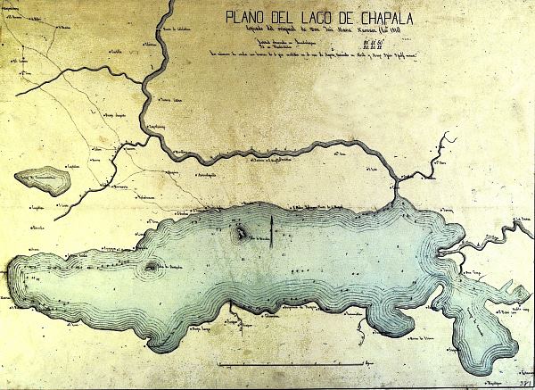
On his return, Narváez was summoned to Lake Chapala, where a group of determined insurgents had installed themselves on the island of Mezcala and were refusing to surrender. General de la Cruz requested help from the Spanish Navy, and Narváez duly obliged. The Royalist troops and the rebels agreed an honorable truce in November 1816, by which time Narváez had begun his map of the lake. He completed the map the following year, and several years later had produced a truly fine map of the entire province of Jalisco, a scaled down version of which, with updated boundaries, became the first official map of the state in 1842.

Copy of Narvaez' map of Lake Chapala

Copy of Narvaez’ map of Lake Chapala

Narváez’s map of Lake Chapala was the earliest scientific map of the lake, and was adapted, with only minor modifications, by many later publications. The map shows the lake to have a maximum depth of 13.86 meters (45 feet) just south of Mezcala Island. Most of the central part of the lake is shown as having a depth of about 12 meters (39 feet). These depths are rainy season values; the dry season depths would probably be about one and a half meters (five feet) shallower.

Following Mexico’s Independence in 1821, Narváez decided to remain in Guadalajara with his family, though his official discharge from the Spanish navy was not granted until May 25, 1825. By that time, he had been appointed Commandant of the Department of San Blas, and had been searching for an alternative location for a major port, since San Blas “has the great defect of not being more than an estuary, incapable of receiving boats that draw more than twelve feet”.

Narváez, the long-overlooked sailor and cartographer, went on to draw many more maps, before he died in Guadalajara, at the age of 72, on August 4, 1840.

His numerous contributions to the accurate mapping of both Mexico and Canada have received surprisingly little recognition, except for a small island named after him off the west coast of British Columbia, and the name Narváez Bay for a gorgeous little bay on Saturna Island (a contraction of Saturnina, the name of his vessel), in the Gulf Islands National Park.

Sources:

  • Boshier, Roger. (1999) Mapping the New World. Education and Technology Research. Part 1: “Neutral” Technology. Vancouver: University of B.C. September 1999. Accessed on line, July 13, 2008
  • McDowell, Jim. (1998) José Narváez. The Forgotten Explorer. Including his Narrative of a Voyage on the Northwest Coast in 1788. Spokane Washington: The Arthur H. Clark Company.
  • Narváez, José María (1816-17) Plano del lago de Chapala. Guadalajara de la Nueva Galicia.
  • Narváez, José María (1840) Plano del Estado de Jalisco. Guadalajara.

Notes:

Jan 272016
 

Mexico has a long history of honey (miel) production. Honey was important in Maya culture, a fact reflected in some place names found in the Yucatán Peninsula, such as Cobá (“place of the bees”).

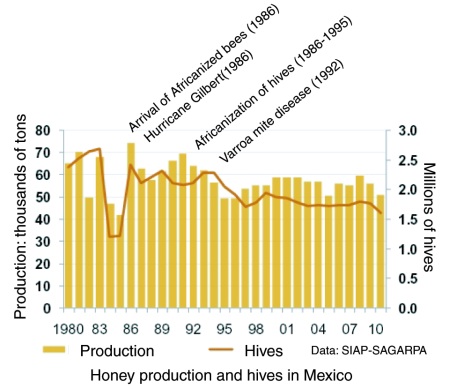
Faced by the arrival of Africanized bees – The diffusion of the Africanized honey bee in North America – Mexico’s modern commercial beekeepers initially feared the worst. With time, they became less antagonistic to Africanized bees, since, whatever their faults, they proved to be good honey producers.

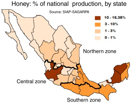
Honey production in Mexico

Main honey producing states in Mexico

Honey production has been on the rise in the past decade. Over the past five years, Mexican hives have yielded about 57,000 tons of honey a year, making Mexico the world’s sixth largest honey producing country. Preliminary figures for 2015 show that Mexico produced 61,881 tons of honey.

Mexico is also the world’s third leading exporter of honey with total exports (both conventional and organic honey) of 45,000 tons in 2015, a new record, worth over US$150 million. Mexico’s principal export markets for honey are Germany, the USA, the U.K. Saudia Arabia and Belgium.

Postage stamp depicting honey exports

Postage stamp depicting honey exports

Other major exporters of honey include China, Argentina, New Zealand and Germany.

There are 42,000 beekeepers nationwide, operating 1.9 million hives; the main producing area remains the southeast, especially the states of Campeche, Yucatán and Quintana Roo. Jalisco, Chiapas, Veracruz, Oaxaca, Guerrero, Puebla and Michoacán are also important for honey production.

The domestic consumption of honey in Mexico has risen from under 200 grams per person in the 1990s to more than 300 grams in 2010. This is mainly due to the use of honey in processed foods such as cereals, yogurts and pastries.

Graph of honey production in MexicoThe major value of bees in an ecosystem is not for their honey production, but on account of their vital role in the pollination of trees and food crops, a contribution valued in the US alone at more than 10 billion dollars.

Views about the pollinating ability of Africanized bees, compared to European or native bees, are mixed. Some farmers dislike having to cope with potentially aggressive bees. Others claim that Africanized bees are far more efficient pollinators than European bees since they forage more often and at greater distances than their European counterparts. The available evidence does not appear to suggest that the arrival of Africanized bees had any impact on crop yields in Mexico.
Which Mexican honey should you buy? For a cautionary tale about choosing the best Mexican honey in overseas stores, see Honey, what’s on that label?

Sources:

  • (a) La producción apícola en México by Carlos Angeles Toriz and Ana María Román de Carlos. (date unknown)
  • (b) “Mexico ranks sixth in honey production” (reprinted from El Economista on mexicanbusinessweek.com), 2011.

This post was first written in October 2011, with updates in October 2015 and January 2016.

Ecocide in Cancún: mangroves destroyed overnight

 Other  Comments Off on Ecocide in Cancún: mangroves destroyed overnight
Jan 202016
 

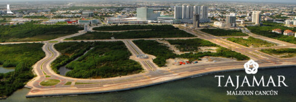
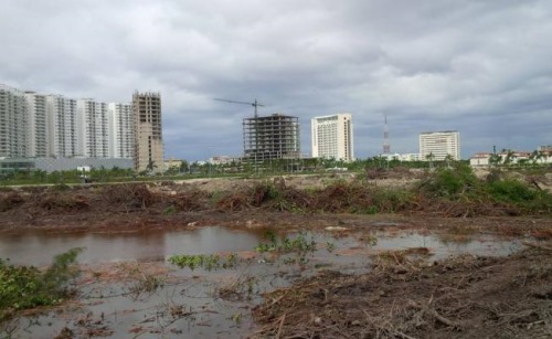
Environmentalists are denouncing the recent overnight destruction of mangroves in the Malecón Tajamar area of Cancún. Malecón Tajamar is a tourist complex with infrastructure financed by Mexico’s federal tourism development agency Fonatur, which has form when it comes to environmental destruction. (See, for example, Conflict at Cabo Pulmo: mass tourism meets ecotourism.)

Development or Environment?

Development or Environment?

Mexico is one of the world’s wealthiest countries in terms of mangroves, with between 600,000 and 900,000 hectares of them in total. (For details about why this range of values is so large, see How fast are mangroves disappearing in Mexico?) To prevent further destruction Mexico enacted federal legislation in 2007 designed to protect existing mangroves.

Credit: Adriana Varillas, El Universal

Credit: Adriana Varillas, El Universal

Despite this, news reports indicate that heavy equipment, protected by armed police, moved in to Malecón Tajamar on 16 January 2016 and proceeded to destroyed 57 hectares (140 acres) of mangroves overnight. This mangrove swamp had been under threat for some time, but the activist movement “Salvemos Manglar Tajamar” had gained considerable public support and managed to bring a temporary halt to further development work in the area.

Greenpeace México alleges that Fonatur falsified environmental assessments, and even denied that any mangroves existed at Malecón Tajamar. According to Greenpeace, municipal, state and federal authorities colluded to ensure that the mangroves would be destroyed and that construction of the tourist complex could continue.

Activists claim that the distinctive and ecologically-important mangrove habitat was home to crocodiles, iguanas, birds and snakes, and that the ecosystem services (fishing, coastal protection, habitat for other species, carbon sequestration, etc) provided by a healthy mangrove swamp outweighed all other options. (For more details, see How valuable are Mexico’s mangrove swamps?)

Greenpeace México not only condemned the destruction of mangroves but called for an immediate halt to work in the area pending a full and open discussion with all stakeholders. They believe that the mangroves could possibly reestablish themselves in time if the area is left untouched.

Work to infill the area cleared of mangroves has now been suspended while animal experts try to rescue, and relocate, as many of the animals who survived the initial disturbance as possible. In theory, Fonatur and the federal Environmental Secreatariat were obligated to ensure that developers had an adequate plan in place, prior to clearance, to relocate all animals, in line with the initial environmental impact report approved in 2005.

Another NGO, Defensores del Manglar, has announced it will submit a formal complaint about recent events at Malecón Tajamar to the headquarters of the Ramsar Convention in Switzerland. The Ramsar Convention, to which Mexico is a signatory, is an international accord for the conservation and sustainable use of wetlands. Defensores del Manglar claims that Malecón Tajamar is protected under the Convention, even though the area does not appear to be specifically included on this list of Mexico’s 140+ Ramsar sites.

Geo-Mexico joins with Greenpeace Mexico and Defensores del Manglar in deploring the destruction of Mexico’s remaining mangroves and will continue to publicize cases where developer greed results in irreversible environmental damage.

Related posts:

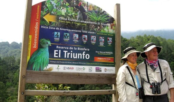
The El Triunfo Biosphere Reserve in Chiapas

 Other  Comments Off on The El Triunfo Biosphere Reserve in Chiapas
Jan 182016
 

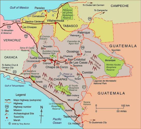
The El Triunfo Biosphere Reserve covers 119,177 hectares in the southern state of Chiapas, in the municipalities of Acacoyagua, Angel Albino Corzo, La Concordia, Mapastepec, Villa Corzo, Pijijiapan and Siltepec. The reserve ranges in elevation from 450 meters above sea level to 2550 meters (8370 ft).

El Triunfo is part of the mountain range known as Sierra Madre de Chiapas in the southern part of the state. It straddles the continental drainage divide. Short rivers on one side flow to the Pacific Ocean. The rivers on the other side of the divide are the start of one branch of the mighty Grijalva-Usumacinta River (Mexico’s largest river in terms of discharge) which flows into the Gulf of Mexico.

el-triunfo

The El Triunfo reserve was first established in 1990. In 1993, it was officially designated a World Biosphere Reserve by the MAB-UNESCO program.

El Triunfo has numerous plants and animals. Its vegetation, representative of several distinct ecosystems, includes evergreen tropical humid forest; mountain rainforest; tropical deciduous rainforest; pine-oak forest; and evergreen cloud forest. On Cerro Ovando alone, about 800 different species of plants have been recorded.

mapchiapas

Map of Chiapas. Click here for interactive map of Chiapas on Mexconnect.com; all rights reserved

Threatened mammalian species found in the reserve include Geoffroy’s spider monkey, margay, the tapir (Tapirus bairdii), jaguar (Panthera onca) and puma. Unfortunately, this means that this is a favored area for wildlife hunters, poachers and traffickers.

The bird fauna is especially distinctive. The reserve is one of the relatively few places in Mexico where ornithologists have the chance to find the horned guan (Oreophasis derbianus), resplendent quetzal (Pharomachrus mocinno), cabanis’ tanager (Tangara cabanisi), azure-ramped tanager and great curassau. The resplendent quetzal is considered one of the most beautiful birds in the Americas, and its feathers were highly prized in pre-Columbian times.

This BBC video is an outstanding visual introduction to the Reserve:

As is the case for other Biosphere Reserves, local people are allowed to live and work in the El Triunfo Reserve. The core area (25,719 hectares) is restricted to conservation and research only, but the buffer/transition areas (93,458 ha) are home to about 12,000 people. El Triunfo is also on the migration route of Guatemalan Indians entering Chiapas either to work (seasonally) on coffee plantations or as the first stage of their journey further north. This floating population is trickier to quantify.

The area was important historically for the production and trade of items such as cacao, quetzal feathers, jade and copal resin. In the 17th century, the population grew rapidly in this region with the establishment of plantations, and later cattle ranches. Coffee was introduced at the end of the 19th century and quickly became the dominant cash crop for most small landowners. Environmental damage, mainly from clearance and cattle ranching, became a major problem, but it was not until the 1970s and pioneering work of Dr. Miguel Alvarez del Toro that any restrictions were placed on land use.

Today, the main economic activities within the buffer areas of the reserve are agriculture (coffee, corn), the collection of Chamaedorea palms, trade, construction and cattle raising.

Several NGOs are working with farmers in the buffer zone to improve their livelihoods and ensure that farming can be carried out sustainably and still support the existing population. For a lively introduction to this topic, try (Co-operative) Value Added on the blog Small Farmers. Big Change. As they say, “a green and more just food system starts with small farmers”.

Related posts:

Cleaning up the Juanacatlan Falls, the “Niagara of Mexico”

 Other  Comments Off on Cleaning up the Juanacatlan Falls, the “Niagara of Mexico”
Jan 142016
 

Geo-Mexico has repeatedly lamented the sad state of the Juanacatlán Falls, the “Niagara of Mexico”, near Guadalajara. More than a century ago, they were considered a national treasure. Indeed, in 1899, they were among the earliest landscapes to be featured on Mexican postage stamps.

In 2012, we reported that Greenpeace demands action to clean up Mexico’s surface waters. Greenpeace activists chose to protest at the Juanacatlán Falls to call attention to the poor quality of Mexico’s rivers and lakes. The activists cited government statistics showing that 70% of Mexico’s surface water was contaminated, mostly from toxic industrial dumping, rather than municipal sewage.

Greenpeace activists at El Salto de Juanacatlán, 22 March 2012. Photo: Greenpeace.

Greenpeace activists at El Salto de Juanacatlán, 22 March 2012. Photo: Greenpeace.

Last year, we returned to the theme and looked at how the Juanacatlán Falls had been transformed from the “Niagara of Mexico” to the “Silent River”.

Our concluding paragraph on that occasion bears repeating:

Is it too much to hope that the government, corporations and society in the El Salto area can all come together to remedy this appalling tale of willful mismanagement? Local residents are right to insist on the enforcement of existing water quality regulations and on the implementation of remedial measures to reverse the decline of this major river and its once-famous waterfalls. Even more importantly, urgent measures are needed to reverse the deteriorating public health situation faced by all those living or working nearby.

Finally, some good news. Author and activist John Pint, who has done far more than most to publicize the scenic wonders of Western Mexico (including dozens of places that fall way outside the usual tourist guides) reports that the inflow from the 66-km-long Ahogado River, one of the rivers that feeds into the Santiago River just before the Juanacatlán Falls is being cleaned up, with a dramatic, positive impact on the beauty of the Falls themselves. According to Pint’s first-hand report and photographs – Is Guadalajara’s most infamous waterfall now clean? – the smelly, toxic foam that has marred the Falls for decades has become a thing of the past. While this does not mean the water is completely clean, it is certainly an encouraging start.

The Ahogado River itself continues to receive pollutants, and its water remains heavily contaminated, but a  300-million-peso treatment plant, which apparently began operations in 2012, is removing some of the worse contaminants prior to the river joining the Santiago River. There is still a lot of work to be done here if the Juanacatlán Falls are going to be restored to their former pristine beauty, but Geo-Mexico is delighted to hear that progress is (finally) being made.

What a shame that it took the death of eight-year-old Miguel Ángel López in 2008, and years of adverse effects on the health of local inhabitants, before federal and state authorities took decisive action. Later this year, Geo-Mexico hopes to revisit the Falls for the first time in twenty years to see just how much they’ve improved. Watch this space!

Related posts:

Dec 292015
 

This short PostandFly.com.mx video, by Enrique de la Cruz and Tarsicio Sañudo, shows the spectacular inland scenery of the state of Chiapas in southern Mexico. The highlights are views of the Sumidero Canyon (near Tuztla Gutierrez, the state capital) and then some magnificent shots of the Lagunas Montebello, near the border with Guatemala, and the river scenery of Agua Azul.

This video is apparently the start of a collaborative effort between PostandFly and photographic director Enrique de la Cruz to generate additional audiovisual resources utilizing new technologies such as drones. We will be keeping our eyes open in the New Year for more.

Want to learn more about Chiapas? A good starting point is our very own Chiapas Map and Index Page, which has links to articles about the geography of the indigenous Lacandon Indians, poverty and inequality, musical instruments, tourism, agriculture, tectonic hazards, and lots more.

Sadly, my one and only trip so far to the Lagunas Montebello was cut short by a vehicle malfunction. At least I was still able to make my way out of the park and back to civilization before nightfall! Presumably cell phones now work in the park, so such adventures are probably a thing of the past.

May you have lots of your own adventures in Mexico in 2016, and always return safely!

Happy New Year to all our readers!
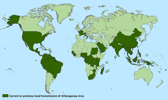
Other video resources on this site:

Mexican clothing and culture exhibition at the Royal Ontario Museum, Toronto

 Other  Comments Off on Mexican clothing and culture exhibition at the Royal Ontario Museum, Toronto
Dec 142015
 

The Royal Ontario Museum in Toronto, Canada, continues to showcase Mexican textiles in a major exhibition entitled Viva México! Clothing and Culture.

The exhibition opened in May this year and closes 23 May 3, 2016. It occupies the museum’s Patricia Harris Gallery of Textiles & Costume. Even though the museum’s collection of Mexican textiles is one of the largest and most important collections of its kind in the world, very few items from the collection have ever been publicly displayed previously.

“Vibrant expressions of creativity, the pieces in this exhibition combine remarkable technical skill with exquisite artistry. Over 150 stunning historic and contemporary pieces are on display, including complete costume ensembles, sarapesrebozos, textiles, embroidery, beadwork and more.”

Rebozo (detail), Ikat-patterned silk, Mexico, 1825-1875. Gift of Mr. and Mrs. W.K. Newcomb.

Rebozo (detail), Ikat-patterned silk, Mexico, 1825-1875. Gift of Mr. and Mrs. W.K. Newcomb.

As the promotional material claims, “The evolution of Mexican fashion reflects the history of Mexico, where the textile arts reach back over many centuries. After the Spanish Conquest of 1521, European styles influenced the distinctive clothing of the Maya, the Aztec and other great civilizations. Contemporary Mexican textiles owe their vitality to the fusion of traditions. ¡Viva Mexico! celebrates this rich and enduring cultural legacy.”

The guest curator for this exhibition is Chloë Sayer, a specialist in Mexican popular art and author of numerous works on the subject, including Costumes of Mexico (1985); Arts and Crafts of Mexico (1990); Mexican Patterns: A Design Source Book (1990); Mexico: The Day of the Dead: An Anthology (1993); Mexican Textile Techniques (1999); Textiles from Mexico (2002); and Fiesta: Days of the Dead & Other Mexican Festivals (2009).

Sayer believes, with good reason, that Mexican textile handcrafts should be named a UNESCO cultural heritage, due to their centuries-old history, and because they are still worn by Mexico’s indigenous peoples. She sees the challenge as being how to ensure that “new generations of Mexicans continue to learn how to make these textiles”

The exhibition comprises about 200 pieces, some dating back to the nineteenth century. “The collection tells the story of Mexican textiles through centuries, and that’s why it’s so valuable,” Sayer said. Sessions when visitors to the exhibition can watch Mexican artists hand-crafting traditional textiles are also scheduled on a regular basis.

There are significant regional differences in the “typical” traditional textiles in Mexico. This exhibition delves into the geography of Mexican textiles and brings long-overdue attention to their extraordinary diversity.

Related posts:

The diffusion of the chikungunya virus across Mexico

 Other  Comments Off on The diffusion of the chikungunya virus across Mexico
Nov 162015
 

It is now just over a year since the first locally locally transmitted cases of chikungunya were reported in Mexico. (Local transmission means that mosquitoes in Mexico have been infected with chikungunya and are spreading it to people).

Distribution of Chicungunya, as of October 2015

Distribution of Chikungunya, as of October 2015 (WHO)

The virus, first isolated in Tanzania in 1952, began to spread rapidly after an outbreak that originated in Kenya in 2004. By 2006, the virus had reached India, and by 2007 northern Italy. Imported cases were identified in Taiwan, France and the USA in 2010. In these stages, chikungunya was spread to new areas primarily by travelers infected with the virus.

The first locally-transmitted cases in the Americas were on the Caribbean island of St. Martin in 2013.

The chikungunya virus was first recorded in Mexico in October 2014 and has since spread rapidly from Chiapas through much of the country (map).

Incidence of Chikungunya, 2015, up to 24 October

Incidence of Chikungunya, 2015, up to 24 October. Data: SINAVE/DGE. Cartography: Geo-Mexico

As of 24 October 2015, 9423 cases have been reported in Mexico in total. The states most affected (in terms of number of cases) are Guerrero (1620 cases since October 2014), Michoacán (1548), Veracruz (1203), Oaxaca (1151) and Yucatán (1131).

Two mosquito vectors (Aedes aegypti and Aedes albopictus) are involved in the spread of chikungunya. Aedes aegypti is exclusively tropical in distribution, but Aedes albopictus also thrives in temperate climes, giving chikungunya the potential to spread virtually throughout the Americas.

The number of cases spikes with the rainy season since mosquitoes breed in stagnant water. Curiously, about two-thirds of the cases in Mexico have been in females, and only one-third in males. Presumably, this is due to differences in work and/or living habits, with females having greater exposure than males to the mosquitoes involved.

There is no vaccine to prevent chikungunya or medicine to treat the viral infection.

The most common symptoms of chikungunya virus infection are fever and joint pain. Other symptoms may include headache, muscle pain, joint swelling, or rash. Joint pains can last months or even years. The disease is debilitating, but rarely fatal. Someone who has contracted chikungunya develops lifelong immunity (unlike dengue fever, where no such immunity exists).

Want to learn more?

Related posts

Nov 132015
 

While writing Geo-Mexico, the geography and dynamics of modern Mexico, we were surprised to find there were no books in English about the geography of Mexico aimed at readers in the upper grades of high school or beginning years of college. On the other hand, we knew of several books about Brazil aimed at that level, most of them published in the U.K.. Why are there more geography books about Brazil than about Mexico?

One attraction of Brazil to geographers is that the spatial patterns of activities in that country are far simpler to describe, map and analyze, than their counterparts in Mexico. For example, compare these two maps of climate zones:

Climate zones of Mexico and Brazil.

Climate zones of Mexico and Brazil. Credit: Geo-Mexico and Wikipedia, respectively.

This makes it easier to teach about the spatial patterns of Brazil than Mexico. Even though regional geography largely disappeared from U.K. schools in the 1970s, most examination syllabi for the equivalent of Grade 13 still required the study of countries at contrasting levels of economic development. Brazil was a relatively popular choice to represent either (initially) an LEDC (Less Economically-Developed Country) or (more recently) an emerging economy or “middle-income” country. Naturally, this led to textbooks based on Brazil.

If further evidence were needed that British schools have tended to ignore Mexico, then look no further than a recent article in Geography, the flagship journal of the U.K.’s Geographical Association, the leading subject association for all teachers of geography in the U.K.

Quoting its website,

The Geographical Association (GA) is a subject association with the core charitable object of furthering geographical knowledge and understanding through education. It is a lively community of practice with over a century of innovation behind it and an unrivalled understanding of geography teaching. The GA was formed by five geographers in 1893 to share ideas and learn from each other. Today, the GA’s purpose is the same and it remains an independent association.”

GEOGRAPHY_vol100_part3_COVERThe Autumn 2015 issue of Geography includes “Twenty-five years of Geography production”, an article by Diana Rolfe analyzing the content of the last 25 years of the publication. One particular section caught our eye. Rolfe lists the number of times that specific places are referred to over that time in the journal’s “place-based articles”.

The analysis shows that 78 countries were referred to in the past 25 years. The most frequently mentioned country (no surprise here) is the U.K., with (139 articles over the past 25 years). The next most frequently mentioned country is South Africa (27 mentions), followed by China (16), France (12), Australia (10), Hong Kong, Ireland and Canada (8 each). Latin American countries do not have a good showing on this list, but are represented by Peru (2), Argentina (1), Brazil (1) and Chile (1).

Astonishingly (to us at least) Mexico does not get a single mention. Neither, it must be said, do Sweden or Norway.

The omission of Mexico from the list is significant, given that it is the world’s 11th largest country in terms of total population, 14th largest in area, is the 9th most attractive country for FDI, and has the 11th largest economy on the planet!

It is an especially puzzling omission, in a U.K. context, given that U.K. investment during the nineteenth century helped unlock the mineral riches of Mexico, finance its banks, build its railway network and so much more.

We invite UK geographers to purchase a copy of Geo-Mexico, the geography and dynamics of modern Mexicocome or hop on over to geo-mexico.com to find out what they’re missing.

Related posts:

Nov 072015
 

A BBVA-Bancomer report, based on Mexico’s 2010 census data includes an interesting graph showing where “Americans older than 50” live in Mexico. The data is based on place of birth, so some of the “Americans” in the data are of Mexican heritage – they were born in the USA, to parents who were born in Mexico, and have since relocated to Mexico.

americans-in-mexico-2010-graph

As the graph highlights, almost half of all Americans living in Mexico live in one of just 20 municipalities. Tijuana, just across the border from San Diego, leads the way, with 6.4% of all the Americans over age 50 living in Mexico, followed by Chapala and San Miguel de Allende, the only two non-border municipalities in the top seven locations for older Americans.

Perhaps no surprise, then, that both these areas have weekly English-language newspapers. The Chapala area is served by The Guadalajara Reporter which covers Guadalajara, Zapopan, Chapala and (to a lesser extent) Puerto Vallarta, potentially reaching 9.7% of all Americans over the age of 50 in Mexico. For its part, San Miguel de Allende has Atención San Miguel. Both locations are popular choices for retirement.

Kudos to “Madeline”, who points out in a comment (below), that there are several other English-language papers in Mexico. They include two in Puerto Vallarta: PV Mirror and the Vallarta Tribune. In Quintana Roo, Playa del Carmen has the Playa Times. In Baja California, there is the biweekly Baja Times and no doubt there are a few others, which we will add in due course! [Based in Mexico City, The News – thenews.mx – was the closest thing to a national daily in English, with distribution points in many parts of the country, but ceased publication in early 2016.]

Related posts: