Mexico’s webcams

 Books and resources  Comments Off on Mexico’s webcams
Jun 292015
 

There are thousands of webcams operating in Mexico offering armchair geographers the opportunity to see up-to-date images of active volcanoes, megacities, archaeological sties, small towns and tourist resorts.

Many of the major webcams are listed at Webcams de México, which has several great features once you’ve chosen a particular webcam, including access to prior images for any date and time, or the ability to compile an instant time-lapse video covering any period of time.

Links to webcams listed at Webcams de México:

Explore Mexico via its webcams! Enjoy!

Related posts:

Good news: tax on sugary drinks in Mexico is decreasing consumption

 Mexico's geography in the Press  Comments Off on Good news: tax on sugary drinks in Mexico is decreasing consumption
Jun 252015
 

On 1 January 2014, the Mexican government implemented a 10% tax on refrescos (aka sodas, pop, carbonated drinks) and other sugar sweetened drinks, raising the price by 1 peso (about 7 cents US) per liter, in an attempt to help curb the nation’s obesity problem. The tax became law despite heavy lobbying against it by the beverage industry. An 8% tax was also added to unhealthy snacks like potato chips and cookies.

Now preliminary results of a study (not yet peer reviewed) by the Mexican National Institute of Public Health and the Carolina Population Center at the University of North Carolina, show purchases of sugary beverages dropped 6% on average across 2014, and by as much as 12% in the last part of the year. The study analyzed consumption in 53 Mexican cities, and adjusted for other factors like the small downward trend in consumption of carbonated drinks in recent years. The effect was greatest in lower income households where purchases were cut by 9% over the year and by 17% in the later months. Moreover, the researchers claim that Mexicans drank more water after the refresco tax came into effect.

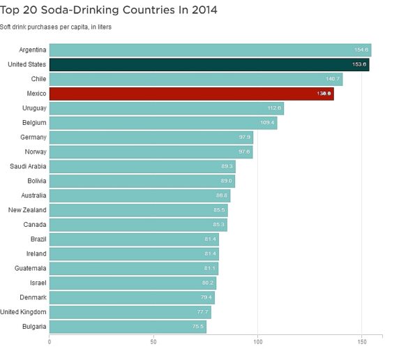
soft-drinks-2014Mexicans’ consumption of carbonated drinks per capita is the fourth highest in the world (behind Argentina, USA and Chile), with the average Mexican drinking the equivalent of 136 liters of Coca-Cola a year. Government revenues from the new tax totaled 18 billion pesos (US$1.3 billion) in 2014. The National Health Alliance, a Mexican public interest coalition, is now calling for the tax to increase to 20%, and for the abolition of tax on bottled water sold in containers of under 10 liters, to make it cheaper than sugary drinks. The Alliance is also pressuring the government to follow through on its promise to use the tax revenues raised to fund programs to prevent obesity and its associated diseases – for example, making free, clean drinking water available in schools that don’t currently have it.

In its March 2015 report on Carbonates in Mexico, Euromonitor International, reporting from an industry perspective, concludes:

(The tax) is one of the many new strategies that the Mexican government is implementing to fight the rising obesity and diabetes II rates after becoming the leading country for obese or overweight citizens globally in 2013…The most affected carbonated products are those sold in big sizes where consumers are more aware of the increased cost. Some leading brands have their stronger position among the biggest sizes of the market, and these brands have seen a greater impact in their volume sales. Amongst carbonates, Coca-Cola (de México SA de CV) holds a 68% total volume share, followed by its closest competitor Pepsi-Cola (Mexicana SA de CV), at 16% .

Carbonates is expected to keep on struggling with volume growth in Mexico due to consumers wanting healthier options, the increasing trend of having RTD teas and increasing trend of fruit-flavoured beverages instead of carbonates. Additionally, government actions have strongly impacted carbonates’ consumption.”

Related posts:

The geography of Mexican farming, agriculture and food production: index page

 Index page  Comments Off on The geography of Mexican farming, agriculture and food production: index page
Jun 222015
 

This index page lists the major posts on Geo-Mexico related to agriculture, farming and food production. Additional agriculture-related posts can easily be found via our tag system.

Post highlighted in red are new additions to the index since the last time it was published.

Enjoy!

General posts related to agriculture and agricultural products:

Individual crops and products:

Other Geo-Mexico index pages:

Community-based ecotourism in La Ventanilla, Oaxaca: success or failure?

 Other  Comments Off on Community-based ecotourism in La Ventanilla, Oaxaca: success or failure?
Jun 182015
 

Ecotourism at La Ventanilla on the coast of Oaxaca, a small community of about 100 inhabitants, located between the beach resorts of Puerto Escondido and Puerto Angel, began more than twenty years ago. It is based on trips run by local guides through the mangroves lining a lagoon on the Tonameca River; the area’s wildlife includes iguanas, birds, crocodiles and sea turtles.

The main local cooperative that conducts tours is called Servicio Ecoturisticos de La Ventanilla (La Ventanilla Ecotourism Services). Income from its tours supports reforestation and other ecological projects, including a greenhouse for mangrove reforestation and a nursery to hatch and raise crocodiles for release on Uma Island, in the lagoon. A breakaway co-operative, Cooperativa Lagarto Real, also runs some local excursions, though its profits do not contribute to local conservation efforts.
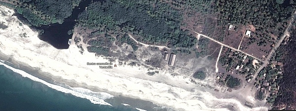
La Ventanilla (Google Earth)

La Ventanilla (Google Earth)

Most visitors to La Ventanilla come only for the day; the small local community offers only limited services or accommodations for tourists. The community of La Ventanilla is often held up as a shining example of how a well-implemented “assistive conservation” ecotourism approach can combine environmental conservation with economic sustainability, while enhancing the local quality of life.

But is this apparent success story quite as idyllic as usually portrayed in the mainstream press? Dr. David Vargas-del-Río, a researcher at ITESO in Guadalajara, sets out to explore this question in his recent article, “The assistive conservation approach for community-based lands: the case of La Ventanilla”, published in the December 2014 issue of The Geographical Journal. The article is based on Vargas-del-Río’s doctorate thesis at the UPC University, Barcelona.

As Vargas-del-Río explains, “The assistive conservation approach includes strategies for conserving community-based lands based on a complex combination of traditional and modern scientific knowledge. It enjoys broad legitimacy and seems promising for conserving territories with autochthonous populations. However, as a novel strategy, it has been applied mostly to societies and environments that are fragile in conservationist terms.”

The author explores how there has been a gradual shift in the protection of natural areas from ‘top-down’ to ‘bottom-up’ models of environmental management, before turning to his case-study of La Ventanilla. La Ventanilla lends itself to such a case study since an assistive conservation approach was first implemented there more than twenty years ago, More than sufficient time to allow for some follow-up evaluation. His eventual conclusion is that while assistive conservation approaches sound good in theory, they may, over time, make local ecologies “more vulnerable to social and environmental degradation, especially as traditional management institutions once responsible for ecological integrity become obsolete”.

In reviewing the background literature, Vargas-del-Río asserts that there are “three broad critical currents” of criticism of the assistive conservation approach. These include the potential adverse impacts of utilizing protected areas for tourism. The provision of attractions, installations and other services, leads to “new dynamics, impacts and transformations” in terms of tourism providers, and may result in “competition between local actors and powerful tourism agents, both conventional and emergent.” Potential issues include changes in local consumption and behavior patterns, and the view that nature and local culture are commodities.

Just how was this manifested in the context of La Ventanilla?

Initial effects of the assistive conservation approach in La Ventanilla were positive. Restrictions were placed, and enforced, on “activities considered ‘disruptive’; that is, hunting, selling local species, harvesting turtle eggs, and felling mangrove trees…”The cooperative soon won praise for its environmental responsibility and received more funds from the government to conduct volunteer conservation projects, including reforestation in the mangroves, a deer reserve, a turtle egg nursery, and areas for iguanas, among other initiatives. Hence, it continued to receive financial and moral power which it exercised over the rest of the population, while promoting conservation and tourism over traditional uses.”

Following extensive fieldwork in the community, Vargas-del-Río found, “a marked tendency towards spatial segregation, social fragmentation, inequality and speculation; phenomena that have emerged as a direct result of the ‘conservation’ initiative with its nature-based tourism activities and imposed environmental restrictions.”The La Ventanilla Ecotourism Services Cooperative (CSELV) is “controlled by six local leaders who own the lands where the cooperative’s main assets are located, handle all accounts, and elaborate support and funding applications.” Other members of the co-operative are “simple wage earners”.

Inequality triggered by the project led to segregation, in terms of housing quality, in the central area of the community. A group of nine disgruntled members of the initial co-operative, broke away in 2004 and founded a second co-operative, Lagarto Real. They “disregarded the management plan”, “sabotaged some conservation and ecotourism initiatives undertaken in this sub-zone, and set up restaurants, shops and camping sites of their own that lacked the ‘green’ image that others were marketing.” The growth of ecotourism has led to land speculation, including a controversy over the construction and (illegal) sale of a small hotel built on communal property.

The island of Uma is controlled by the original co-operative and no longer accessible for traditional activities such as agriculture. There has been a dramatic shift in economic activities. “Agriculture and fishing are now practiced by just 7% of inhabitants and represent an important source of income for only 10.7% of households. In contrast, tourism-related activities occupy 34.7% of the people, represent 70.1% of the economically active population, and are the main source of income for 67.9% of households.”

Vargas-del-Río concludes that previous assessments failed “to take into account slow, gradual changes”. One outcome has been “a higher risk of land degradation in social and environmental terms as the local society fragments, inequality increases, more actors (external and local) strive to profit from the territory, and regulation becomes more difficult.”

In conclusion, “assistive approaches modify ways of approaching nature, restrict traditional uses in favour of tourism, weaken local management institutions and degrade environmental and social relations.” The assistive approach “undermines the cultural, economic and local environment while creating new spaces for consumption.”

Source:

David Vargas-del-Río, 2014. “The assistive conservation approach for community-based lands: the case of La Ventanilla”, The Geographical Journal, Vol. 180 #4 (December 2014) 377–391.

Related posts:
Jun 152015
 

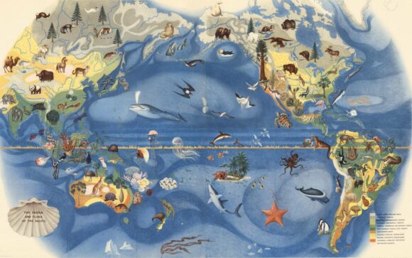
Visitors to the De Young Museum in San Francisco can admire a wonderful mural showing the fauna and flora of the Pacific, painted by Mexican artist José Miguel Covarrubias (1904-1957) for the city’s 1939-1940 Golden Gate International Exposition on Treasure Island in San Francisco Bay.

Covarrubias Mural of the Pacific

Covarrubias Mural of the Pacific (Click image to enlarge)

Following conservation work performed by experts in Mexico, the mural is currently on loan to the De Young Museum from its owners, San Francisco’s Treasure Island Development Authority.

While the De Young Museum website continues to describe this mural as “one of a six-part series of fanciful, larger-than-life-size maps created by noted Mexican artist Miguel Covarrubias”, we sincerely doubt that these murals were ever really “larger-than-life-size”!

The mural is one of the five remaining murals painted by José Miguel Covarrubias for the exposition. The whereabouts of a sixth mural, which completed the series known as “Pageant of the Pacific”, are unknown.

The details are exquisitely painted, and the mural is as beautiful as it is educational.

covarrubias-flora-fauna-north-america-sm

Covarrubias: Mural of the Pacific (detail)

As ever-erudite Jon Haeber writes in his blog post about this mural, painted “at a critical juncture in America’s history”, its artist “was a confidante of Mexican greats Diego Rivera and Frida Kahlo. As a caricaturist for Vanity Fair and The New Yorker, it could easily be assumed that Covarrubias is largely ignored by fine art historians, but he was an anthropologist and geographer as much as he was an artist, which gave him a unique respect among art aficionados… Not only are they an informative lesson in Geography, but they are also a great piece of history – to say nothing about their creator.” [http://www.terrastories.com/bearings/covarrubias-art-forms-pacific viewed June 2015]

Covarrubias was indeed a geographer and ethnologist. Among other works, he authored Island of Bali (1937); Mexico South (1946); The Eagle, the Jaguar, and the Serpent – Indian Art of the Americas; North America: Alaska, Canada, the United States (1954); and Indian Art of Mexico and Central America (1957).

The temporary structures on Treasure Island were subsequently demolished and Covarrubias’ six murals sent to the American Museum of Natural History in New York. When they were brought back to California in the late 1950s, the series was missing the mural entitled “Art Forms of the Pacific Area”. The titles of the five surviving murals are The Fauna and Flora of the Pacific, Peoples, Economy, Native Dwellings, and Native Means of Transportation.

The River Santiago and the Juanacatlan Falls: from the “Niagara of Mexico” to the “Silent River”

 Books and resources, Mexico's geography in the Press  Comments Off on The River Santiago and the Juanacatlan Falls: from the “Niagara of Mexico” to the “Silent River”
Jun 112015
 

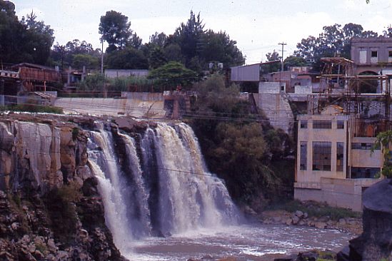
In summer 1987, while living in Guadalajara, I entertained a fellow UK geographer, who arrived with a long list of places he wanted to visit. Over the next few weeks, we ticked them off one by one. Near the end of his visit, he asked why I hadn’t yet taken him to see the famous Juanacatlán Falls, the “Niagara of Mexico”, despite them being in his “top ten” places to see. “OK”, I said, “let’s go!”

Traffic was heavy and as we drove across Guadalajara, I could see his impatience building. Finally, he asked me, “Where are they? How close are we?” I replied that we were “fairly close” but that I was absolutely certain that he would recognize them before they came into sight. A few minutes later and he screwed up his nose and said, “Ughh. What’s that smell?” “See?”, I said triumphantly, “I knew you’d recognize them before you saw them!”

Juanacatlán Falls in 1989. Photo: Tony Burton. All rights reserved.

Juanacatlán Falls in 1989. Photo: Tony Burton. All rights reserved.

Even thirty years ago, long before NAFTA, the Juanacatlán Falls were a sorry sight (and source of a worse smell). Since then, and since NAFTA, they have only become worse. These once-majestic falls, the first Mexican landscape on a postage stamp back in 1899, have been reduced to a trickle of foul-smelling effluent. At the start of the twentieth century, the falls provided hydro-electric power for Guadalajara and turned the wheels of a cotton and woolen mill, the ruins of which now stand to one side.

A recent piece of investigative journalism about the River Santiago, the river which created these waterfalls, makes for disturbing reading. It provides plenty of evidence that the rapid increase in factories along the river, mainly post-NAFTA, may have provided 50,000 new jobs, but has also led to worsening water quality to the point where exposure to the river presents a serious public health risk.

In “River of Death“, Steve Fisher lays bare the terrible reality faced by those living and working close to the river. This is a harrowing tale, with heart-rending testimony from several local residents. On a positive note, the related video, Fusion Investigates: Silent River (below) describes how Sofía Enciso and her family have defied death threats and are determined to confront the factories responsible, while demanding that the relevant authorities take action to enforce federal water quality regulations, and start to clean up the river.

Perhaps the most telling single statistic is that precisely zero companies were fined for failing to comply with water discharge regulations between 2005 and 2011.

In the video, the mayor of El Salto, the main town near the Juanacatlán Falls, claims that the river has become polluted in the past thirty years. I guess he must be too young to remember that they were seriously polluted long before that.

Is it too much to hope that the government, corporations and society in the El Salto area can all come together to remedy this appalling tale of willful mismanagement? Local residents are right to insist on the enforcement of existing water quality regulations and on the implementation of remedial measures to reverse the decline of this major river and its once-famous waterfalls. Even more importantly, urgent measures are needed to reverse the deteriorating public health situation faced by all those living or working nearby.

Related posts:

Jun 082015
 

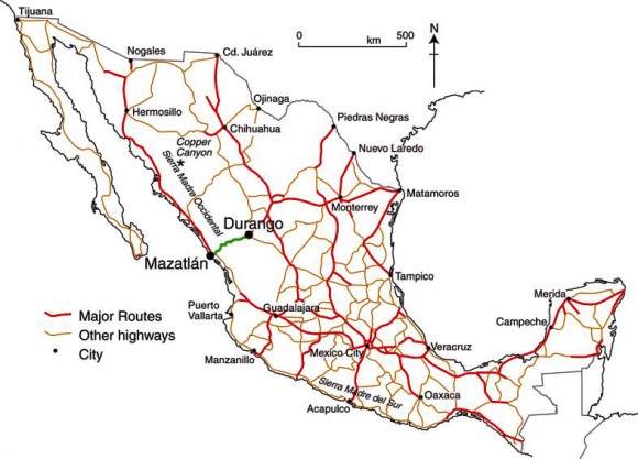
Mexico’s official online database of all the country’s roads and highways has just been updated. As of May 2015, Mexico has a total of 322,859 kilometers of roads and highways.

They are all shown on a map accessed via this web-page. [Link to http://www.imt.mx/micrositios/sistemas-de-informacion-geoespacial/servicios-tecnologicos/red-nacional-de-caminos/ver-datos.html no longer working.]

Mexico's major highways (Fig 17-3 of Geo-Mexico, the geography and dynamics of modern Mexico).

Mexico’s major highways, 2009 (Fig 17-3 of Geo-Mexico, the geography and dynamics of modern Mexico). All rights reserved.

Here is a summary of some of the more useful statistics found in the database:

  • 158,180 km of paved highways, including
    • 48,685 km of federal highways,
    • 92,590 km of state highways
    • 9412 km of toll highways
  •  36,139 km of urban roads
  • 118,812 km of rural (unpaved) roads.

The highway network connects 25,844 places, and has links to 39 ferry routes. It also includes 847 toll stations, 3476 bridges and 178 tunnels.

According to the report, Mexico currently has 6480 gas stations. However, this number is expected to increase rapidly in the next few years as competitors enters a market over which PEMEX previously held a monopoly, prior to recent energy reform laws.

If you are planning to drive across Mexico, then the online system at http://ttr.sct.gob.mx/mappir/ will give you routes, distances and estimated times and costs.

Further reading:

Earthshots: Satellite Images of Environmental Change: Angangueo, Mexico

 Books and resources  Comments Off on Earthshots: Satellite Images of Environmental Change: Angangueo, Mexico
Jun 042015
 

In 2015, the USGS published a series of satellite images of environmental change [no longer online] of the area around the town of Angangueo in the eastern part of the state of Michoacán (very close to the border with the State of México) and the mountainous hillsides covered in pine-fir forest where the migrating Monarch butterflies spend their winters.

The pine-fir forests are found at an elevation of around 3000 meters (10,000 feet) above sea level. The butterflies congregate in a small number of locations, forming massive clumps on the trees. Any major disturbance, such as a windstorm or excessive snow, can cause the loss of (literally) millions of Monarchs. The overwintering Monarchs need just the right range of temperatures. On the one hand, they must not be so cold that they freeze or are not warm enough to flutter in search of food and water. On the other hand, if it is too warm, they may burn through their energy reserves or need to replenish too much moisture. The canopy of the pine-fir forest provides some protection, but even a partial thinning of this canopy will change the microclimate beneath.

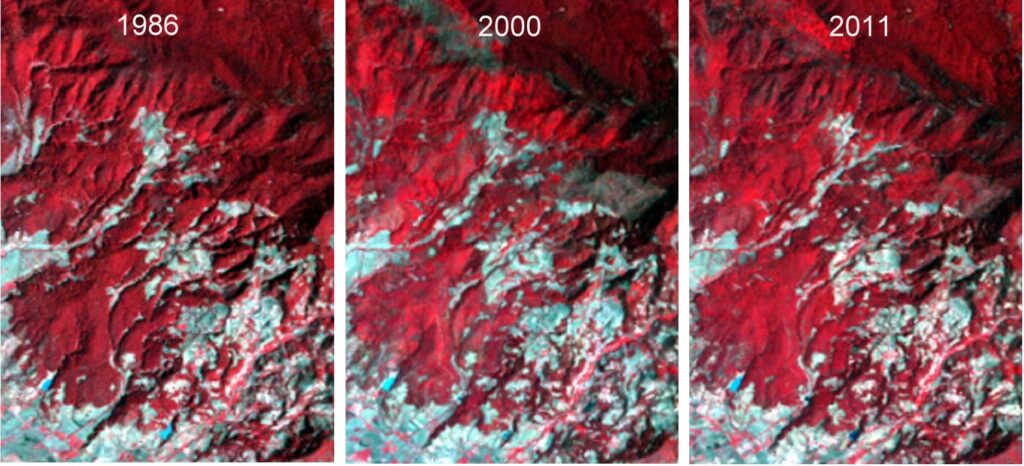
In this post, we will will take a quick look at the images of Chincua reserve. This reserve includes the location where overwintering congregations of Monarch butterflies were reported for the first time in the mid-1970s. This is one of the areas where conservationists fear that the pine-fir forest (appearing vibrant red in the images) may have suffered too much clearing and thinning, which may have altered the area’s microclimate and made it unsuitable for successful overwintering.

When looking at the images, bear in mind that:

    • Red signifies healthy vegetation.
    • Landsat images are always taken in mid-morning, so shaded northwest slopes look darker. Shadows can vary slightly from one month to the next.
    • The images show forest clearance, but do not reveal forest thinning. The consequences of forest thinning (the removal of individual trees) may be just as significant in the context of the annual Monarch butterfly migration.
Satellite images of Chincua reserve, 1986, 2000 and 2011.

Satellite images of Chincua reserve, 1986, 2000 and 2011. Click to enlarge.

In the 2000 image, the Chincua reserve shows some rashy gray areas just above and to the right of the center of the image. These gray areas are not visible on the 1986 image. This may be evidence of a fire, or some other kind of clearing. The 2011 image seems to indicate that the vegetation in that area has recovered, at least to some extent.

A truly detailed examination of these images is beyond the scope of this short post, but high-resolution images (which can be downloaded from the USGS site) will repay a closer study. See, for example, the satellite images of Pelon.

Finally, it is worth remembering that the Monarch as a species is not endangered. There is, indeed, a year-round population of Monarchs in central and western Mexico that is non-migratory owing to the ready availability of milkweed, the only plant on which female Monarchs lay their eggs, throughout the year. It is only the butterfly migration that is considered an “endangered phenomenon”, and all three countries involved (Canada, USA and Mexico) have now instituted programs to try to ensure its long-term success.

Satellite monitoring of the areas of importance to the Monarch butterfly should help identify the key areas on which conservation efforts need to be focused.

Related posts:

Mexican-themed garden wins gold at UK’s Chelsea flower show

 Mexico's geography in the Press  Comments Off on Mexican-themed garden wins gold at UK’s Chelsea flower show
Jun 012015
 

The U.K. has declared 2015 as the “Year of Mexico” and is hosting numerous cultural and trade events this year related to Mexico. Not to be outdone, a Mexican-themed Pavilion exhibit has won gold at the prestigious Chelsea Flower Show, held in London in May. The show is organized each year by the Royal Horticulture Society and was first held more than a century ago.

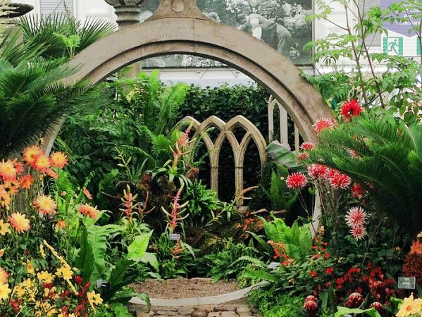
The gold-medal winning garden design in 2015 was based on a very unusual garden created in Mexico by the eccentric Englishman Edward James at “Las Pozas” (the Pools), the home he built near Xilitla in the state of San Luis Potosí. James (1907-1984) was a sponsor of the surrealist art movement, as well as a surrealist artist in his own right. His entire estate in Mexico became his canvass for a marvelously-creative collection of sculptures and follies set in luxuriant, semi-tropical jungle.

The winning garden at Chelsea, entitled “Surreal Pillars of Mexico,” was designed by Jon Wheatley and sponsored by HSBC and the U.K.’s National Dahlia Collection. The dahlia is Mexico’s national flower:

Chelsea Garden Show

Surreal Pillars of Mexico (partial view)

“Surreal Pillars of Mexico” had a circular structure and pillars that emulated Edward James’s garden in Mexico. It included 50 different types of dahlias, surrounded by over 100 plants and vegetables such as lettuce, cactus and the exotic agave plant.

New varieties of dahlias, first described in Mexico in 1529, had been developed via selective breeding and propagation programs even in pre-Columbian botanical gardens. The dahlia arrived in the U.K. in the early nineteenth century, via Spain and only after several unsuccessful attempts at introducing it. The National Dahlia Collection in the U.K. cultivates and promotes the flower; all the varieties existing in the U.K. originated from just three types of dahlias.

The Year of Mexico to the United Kingdom includes more than 100 separate exhibitions, concerts, festivals, academic workshops and artistic residencies; as well as trade missions, research projects, grants and scholarships. These shows will highlight the creativity of Mexican writers and artists, while also showcasing the country’s history and its modern-day industrial strength.Events are being held at a number of cities, including London, Cardiff, Edinburgh, Belfast, Manchester, Oxford, Liverpool and Birmingham.

Related posts: