Repainting the walls of Palmitas in Pachuca leads to reduced crime

 Mexico's geography in the Press  Comments Off on Repainting the walls of Palmitas in Pachuca leads to reduced crime
Jul 302015
 

Palmitas is a small, densely-populated neighborhood in the city of Pachuca, the capital of the state of Hidalgo in central Mexico. It has a reputation for higher than average levels of deprivation, crime and violence.

An innovative social development project, based on artistic transformation, has turned Palmitas over the past few months into a rainbow-hued, quasi-kaleidoscopic, example of urban renewal.

palmitas-foto-jorge-gonzalez

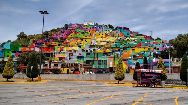
Palmitas, 2015. Photo credit: Jorge González / UNIÓN Hidalgo

The project involved four main players: an art collective (“Germen Crew”), the city government, Comex (a major national paint manufacturer) and a youth organization that was previously better known for its graffiti art.

The youths joined “Germen Crew” and painted 209 houses, some 20,000 square meters of facade in total, into a single rainbow mural. The specialized materials used, supplied by Comex, have provided maximum long-term protection for the dwellings while turning the streets into ribbons of color. The greatest challenge was that many of the exterior walls were in a very rough shape, and some had never been properly finished or protected.

The “macro mural” has been called the “world’s largest” in some news reports. This title is hotly disputed; other contenders include a mural in Berlin and the Pueblo Levee Project in Colorado.

According to streetartnews, the community involvement in this project from start to finish, led to positive effects on 452 families (1808 people), and a dramatic fall in youth violence, to the point of almost eradicating it.

All the homes were first painted white to symbolize the unity of the community, that all community members are equal, and that all members of the community would benefit from the urban renewal. This pair of photos shows before and after images of Palmitas:

crew-germen-graffiti-town-mural-palmitas

Alongside the months of paintings, numerous community events were held to foment participation and a sense of local ownership of the project.

This short video on Youtube (Spanish) describes the project:

The colorful Palmitas project is an unusual and interesting example of urban improvement, urban renewal or urban regeneration.

Comex has said that it will support similar urban renewal projects elsewhere in Mexico that beautify the local settings and help improve people’s lives, so please report back if you find a similar project happening in your neighborhood.

Related posts:

The Trans-Isthmus mega-project

 Mexico's geography in the Press  Comments Off on The Trans-Isthmus mega-project
Jul 272015
 

A huge industrial development plan looks set to get underway shortly in the narrow Isthmus of Tehuantepec in southern Mexico. The low-lying Isthmus of Tehuantepec separates the Chiapas Highlands and the low Yucatán Peninsula from the rest of Mexico. The Isthmus was once considered as an alternative location to Panama for a trans-continental canal.

During Mexico’s internal Reform War (1858‑60), between the liberals, led by Benito Juárez, and the conservatives, both sides encountered serious financial problems. At one point in this war, the liberals accepted an offer from the USA to receive four million pesos in exchange for the USA having the “right of traffic” across the Isthmus of Tehuantepec “in perpetuity”. Fortunately, this treaty was never ratified by the US Senate.

Proyecto-Transistmico

In recent years, the Tehuantepec area has received massive investments in wind power, with several major wind farms already operational and more on the drawing board. The latest plans will build on those investments to provide upgraded infrastructure meeting the preconditions for industrial development.

The 300 million dollars allocated to the first phase of the Trans-Isthmus Project will improve railroads, highways, airports, and the ports of Coatzacoalcos on the Gulf Coast and Salina Cruz on the Pacific Coast (see map).

During the second phase, private sector financing will add industrial development areas, which should boost the area’s contribution to national GDP from 2% to 4.5%, and raise the regional GDP/person to $10,000 a year, close to the national average.

The federal government has designated this region as a special economic zone, offering several fiscal incentives to new enterprises. Chinese investors have already expressed interest in building a 200-million-dollar steel manufacturing plant in the isthmus, utilizing nearby iron ore reserves to produce 3 million tons of steel a year.

Posts related to the same general area of Mexico:

Historic photo of the month: Mexico City cave-dwellers

 Other  Comments Off on Historic photo of the month: Mexico City cave-dwellers
Jul 232015
 

A shout out to Marcia Ambler for sharing, via email, her memories of Mexico City in the 1950s. Among other things, she recalled how she lived as a child with her family, “in a suburb of Mexico City, where there was a deep barranca with people who lived as cliff dwellers in the barranca walls. There was also a cave nearby with a deep drop which I went in with my friends.”

Her email brought back some fond personal memories of Mexico City from the late 1970s and early 1980s. Shortly after I moved to the city, Time Life published The Great Cities: Mexico City, by John Cottrell. I found this book fascinating at the time, and a quick re-read earlier this week confirms that it still well worth looking for (inexpensive copies available via Abebooks) if you are interested in what makes one of the world’s largest cities tick.

Mexico City cave dwellers. Photo by from The Great Cities: Mexico City" (Time Life books).

Mexico City cave dwellers. Photo by Harold Sund in “The Great Cities: Mexico City” (Time Life, 1979).

Like most Time Life books, it is lavishly illustrated, which brings me back to the caves and cave dwellers, since one of the photos (above), by Harold Sund shows the area that Marcia remembers, and which was also my first introduction to the curious world of relatively modern-day troglodytes in Mexico City.

Sund’s photo shows the Belén de las Flores community, relatively close to western end of Chapultepec Park, though there may well have been, and almost certainly were, several similar settlements elsewhere. This short newspaper article, from the Bangor Daily News in 1978, describes the “year-round comfort” that can be enjoyed in such caves.

I haven’t had the opportunity to revisit this area of Mexico City for more than thirty years, so I’m anxious to know what it looks like now.

Sincere thanks, Marcia, for your message which certainly took me on a trip down memory lane!

Source of photo:

  • John Cottrell. 1979. The Great Cities: Mexico City (Time Life Books, 1979). Photography by Harold Sund.

Related posts:

Latest additions to Mexico’s Protected Natural Areas

 Mexico's geography in the Press, Updates to Geo-Mexico  Comments Off on Latest additions to Mexico’s Protected Natural Areas
Jul 202015
 

Alejandro del Mazo Maza, head of Mexico’s Commission for Protected Natural Areas (Áreas Naturales Protegidas), says that the formal decrees for seven additional PNAs (Protected Natural Areas) will be published shortly. In some cases, the decrees apply to areas whose status as protected areas was first announced months or even years ago.

The seven new additions are in the north and northwest regions of the country:

  • the Marismas Nacionales biosphere reserve in Sonora
  • Monte Mojino (protected area of flora and fauna), Sonora
  • the Sierra de Tamaulipas biosphere reserve
  • the Playa Boca de Apiza sanctuary in Colima
  • the Islas del Pacífico of Baja California reserve
  • the Semiarid Desert reserve of Zacatecas
  • the Sierras la Giganta y Guadalupe reserve in Baja California Sur

Mexico currently has 177 PNAs (in various categories), and the new additions bring that total to 184.

In addition, preparatory studies are underway to establish two additional biosphere reserves, for the Mexican Caribbean and the Gulf of California (Sea of Cortés).

Mexico's Protected Areas (Gallina, 2012)

Mexico’s Protected Areas (Gallina, 2012)

The Commission of PNAs is working hard to complete formal management plans for every PNA – environmental, social and economic issues. At present, only 97 of the 177 PNAs have such plans in place, with the latest plans published only weeks ago for:

For example, the management program for the whale shark reserve authorizes a maximum of 160 whale-watching boats in an effort to ensure sustainability.

Source of Map:

Sonia Gallina, 2012. “Is Sustainablity Possible in Protected Areas in Mexico? Deer as an Example of a Renewable Resource.” Sustainability 2012, 4 (10), 2366-2376

Related posts:

Mexico has a 2015 population of 121 million people

 Updates to Geo-Mexico  Comments Off on Mexico has a 2015 population of 121 million people
Jul 162015
 

The latest population estimates released by the National Population Council (Conapo) to coincide with World Population Day show that Mexico has a population in mid-2015 of 121,783,280. Of this total, almost 43 million (35.4%) are adolescents, between 10 and 29 years of age.

A spokesperson for Conapo drew attention to the fact that Mexico still needs to do more to overcome gender inequality in fields such as education, salaries and working conditions.

Related posts:

Recent eruptions of Colima Volcano, el Volcán de Colima

 Mexico's geography in the Press  Comments Off on Recent eruptions of Colima Volcano, el Volcán de Colima
Jul 122015
 

Colima Volcano (aka el Volcán de Colima or el Volcán de Fuego) continues to erupt, displaying its fiery temper by throwing massive plumes of ash and smoke several kilometers into the air. One recent eruption caused a plume of ash seven kilometers high.


Following the eruptions of 10 and 11 July 2015 (see video clip from Webcams de México), a state of emergency has been declared by the state of Colima in 5 municipalities: Colima, Comala, Coquimatlán, Cuauhtémoc and Villa de Álvarez. This enables rapid access to state and federal funds in preparing to cope with any potential disaster.

A precautionary evacuation has been ordered of all communities within a 12-kilometer radius of the volcano’s crater. The 50-60 residents of the closest community to the volcano, La Yerbabuena, live barely eight kilometers (five miles) away from the crater. Five centimeters (two inches) of ash fell on La Yerbabuena in the past few days.

Authorities are concerned that heavy summer rains could generate dangerous and very fast-moving lahars. Lahars are mudflows of volcanic ash, pumice and rocks; they can travel at velocities of up to 100 km/h and move huge boulders and objects as large as houses.

Where is Colima Volcano (Volcán de Colima)?

Location of Colima Volcano

Location of Colima Volcano (Volcán de Colima). Credit: Tony Burton / Geo-Mexico

The volcano is one of the westernmost volcanoes in Mexico’s Volcanic Axis, which straddles the country from west to east. Colima Volcano’s summit is only 8 km (5 miles) from the inactive Nevado of Colima volcano, Mexico’s sixth-highest peak, which rises 4260 m (13,976 ft) above sea level. (Lovers of geographical trivia should note that, despite their names, the summits of both volcanoes are actually located in the state of Jalisco, not in the state of Colima.)

Colima Volcano is considered one of Mexico’s most dangerous volcanoes. Numerous villages in its shadow keep a wary eye on its level of activity, and emergency evacuations have become a regular event over the past fifty years.

How high is Colima Volcano?

The elevation of Colima Volcano is officially given as 3820 m (12,533 ft) above sea level. In the past 400 years, it has been the most active volcano in Mexico, having erupted at least 30 times since 1576. Recent activity means that this exact height may no longer be correct.

The eruption of Colima Volcano on 21 January 2015, shown in this short video, is typical of recent activity.

How often does it erupt?

Historically, the eruptions of the volcano have fallen into a definite cyclical pattern with periods of activity, each lasting about 50 years, interspersed with periods of dormancy. The first cycle of activity (after the Spanish arrived in Mexico) was between 1576 and 1611. Major eruptions occurred in 1680 and 1690, and further complete cycles occurred between 1749 and 1818, and from 1869 to 1913.

The current eruption cycle

Most geologists agree that current activity is part of the fifth cycle, which began in 1961. Judging by past performance, we should be nearing the end of this cycle, though volcanoes can be extremely unpredictable, so don’t bet your house on this happening within the next decade.

Activity has intensified in the past couple of years. In early 2013, we reported that Colima Volcano had erupted, destroying a lava dome first created in 2007 and later that year we looked at how Popocatapetl Volcano and Colima Volcano continued to erupt. At that time, experts monitoring the volcano were reporting up to 200 eruptive events a day, with numerous minor emissions of lava. Colima Volcano has been exhibiting four distinct types of volcanic activity in recent years:

  • lava dome growth
  • explosive eruptions
  • flank collapse
  • lava flows.

In early 2015, activity began to intensify, with several spectacular eruptions, sending ash and dust up to 8 or 9 kilometers (5-6 miles) into the air. Ash fell on towns up to 25 kilometers (15 miles) away from the volcano, in locations including Tuxpan, Zapotiltic and Ciudad Guzmán, but with no loss of life, or significant property damage.

The volcano can be viewed via this permanent fixed webcam operated by Webcams de Mexico. Below the main image on that site are links to 1-minute time-condensed videos showing the past 24 hours of activity.

Three maps (PDF format, Spanish-language keys and text) showing the areas likely to be affected by the volcanic hazards associated with Colima Volcanocan be found via this webpage of Mexico’s National Center for Disaster Prevention (Centro Nacional de Prevención de Desastres, CENAPRED). :

The area around the Colima Volcano is described in more detail in chapter 15 of my Western Mexico, a Traveler’s Treasury (4th edition; Sombrero Books, 2013).

Related posts:

Jul 092015
 

The Jalisco state government has released an informative 5-minute video highlighting some of the reasons why Jalisco is one of the best locations in Mexico for farming, business and tourism.

The video can be viewed on Facebook: Esto es Jalisco. This is Jalisco.

Following opening shots showing some of the diverse landscapes of the state, including the Piedrotas at Tapalpa, the majestic Volcán de Colima (whose summit is actually in Jalisco, not Colima) and the Horseshoe Falls near the Dr. Atl park on the northern edge of Guadalajara, the video’s subtitles (in English) turn to techno0logy and innovation. Jalisco is the first state in Mexico to have a Ministry of Innovation, Science and Technology. The state capitol Guadalajara is the center for MIND (Mexican Innovation and Design Center) and was chosen by MIT for the establishment of a Creative Digital City.

Map of Jalisco state

Map of Jalisco. Copyright 2010 Tony Burton. All rights reserved.

The city also has major cultural and sporting attractions, from libraries to golf courses to hosting international events in the Expo Guadalajara to concerts and its own international film festival. It also hosts the world’s second largest book fair (after Hamburg). Its industrial activity ranges from agro-processing (including tequila) to pharmaceuticals, information technology, automotive and aerospace firms to renewable energy enterprises.

Foreign investment in Jalisco has risen by an average of 17% a year for the past decade, with foreign firms finding the state’s geographic position advantageous for serving central Mexico and with excellent trade links to Asia and the U.S.

The state’s leading coastal resort is Puerto Vallarta, but tourism is also important in the state’s interior. Jalisco has five places with Magic Town status: Lagos de Moreno, San  Sebastian del Oeste, Tapalpa, Mazamitla and Tequila.

Jalisco currently accounts for 6.6% of national GDP and the state government clearly expects this contribution to grow in coming years. This professionally-produced video is an excellent visual introduction to one of Mexico’s most important states.

Related posts:

Mexican artist-geographer helped put Bali on the tourist map…

 Other  Comments Off on Mexican artist-geographer helped put Bali on the tourist map…
Jul 062015
 

In an earlier post – Mexico in the USA: Pacific fauna and flora mural in San Francisco – we looked at the beautiful (and very geographic!) mural by Mexican artist José Miguel Covarrubias (1904-1957).

Covarrubias had a lengthy commercial art career as an illustrator of books, designer of theater sets and costumes, and as a caricaturist for magazines including Vanity Fair and The New Yorker, but at heart, he was very much a geographer, with a healthy side-interest in ethnology.

In the mid-1920s, he moved to New York, where he fell in love with a young dancer and choreographer Rosa (Rosemonde) Cowan. The couple traveled together to Mexico, the Caribbean, Africa and Europe. In Mexico, Rosa met Miguel’s friends, including Diego Rivera and his wife Frida Kahlo, and was introduced to photography by Edward Weston.

Miguel’s illustrations for advertisers, especially the one he painted for Steinway & Sons pianos, helped speed up the inclusion of Bali, Indonesia, on the world tourist map. Miguel’s piano artwork won the 1929 National Art Directors’ Medal for color painting. After Miguel and Rosa married in 1930, they used the prize money to take an extended honeymoon to Bali.

Miguel Covarrubias: "Offering of Fruits for the Temple", Bali, 1932

Miguel Covarrubias: “Offering of Fruits for the Temple”, Bali, 1932

The couple loved Bali and quickly became interested in the local language and culture. Three years later, in 1933, Miguel was awarded a Guggenheim Fellowship, and the couple returned to Bali, also visiting Java, India and Vietnam. Miguel’s art and Rosa’s photographs were key ingredients in the success of Island of Bali (1937).

The book was released in New York at a particularly propitious time, just as interest in far-flung tourism was being fired up by travel firms. The book coincided with, and refueled, a craze among well-to-do New Yorkers to visit the island. The rest of the world soon followed, and Bali’s tourist future was guaranteed.

Island of Bali is “still regarded by many as the most authoritative text on Bali and its fascinating people. Included is a wealth of information on the daily life, art, customs and religion of this magical ‘Island of the Gods.'” For more about the book, see Miguel Covarrubias: Island of Bali. on Chris Morrison’s blog Thirty-Two Minutes.

Miguel Covarrubias’s later books included Mexico South (1946); The Eagle, the Jaguar, and the Serpent – Indian Art of the Americas; North America: Alaska, Canada, the United States (1954); and Indian Art of Mexico and Central America (1957).

Related posts:


Ground-breaking mapping of Mexico’s drug war

 Mexico's geography in the Press  Comments Off on Ground-breaking mapping of Mexico’s drug war
Jul 022015
 

During the 2006-2012 federal administration, it was possible to map the incidence of crime across the country, with data readily available at both the state and the municipal level. The current administration of President Enrique Peña Nieto has diverted press attention away from the drugs-related violence, arguing that press coverage only serves to give more publicity to the bad guys. Unfortunately, that decision means that it has now become next to impossible to get regularly updated data for, or be able to map, the patterns of criminal activity.

This is one of the inevitable caveats that limits the future application of the ground-breaking methods (using data from 2007 to 2011), developed by Jesús Espinal, a quantitative analyst at the National Institute of Genomic Medicine in Mexico City,and Hernán Larralde, statistical physicist at the National University (UNAM). Their work is described in “Mapping Mexico’s deadly drug war“, in Science magazine.

Mapping by Jesús Espinal Enríquez in Science magazine. Click to enlarge.

Mapping by Jesús Espinal Enríquez in Science magazine. Click to enlarge.

Essentially, they took official data for the location and date of all drug-related homicides in Mexico. They built a complex month-by-month network looking for temporal correlations in the homicide numbers between different cities. “If cities shared a death rate higher than 70 casualties per 100,000 inhabitants in a year and were less than 200 kilometers apart, Larralde and Espinal linked them together on their map to tease out broader geographical patterns.”

The results (summarized by the maps) are interesting. They show the rapid spatial spread of violence during the administration of Felipe Calderón as his government waged its war on drug cartels. The map for 2011 suggests that violence may have been finally becoming less widespread and becoming more focused on a relatively limited number of places.

Two major points are worth emphasizing. First (and as we have repeatedly pointed out in previous posts on this subject), the incidence of violent crime, including homicides, is certainly not similar across the entire country. Some states have much higher homicide rates than others; some municipalities have much higher rates than others. Some parts of the country, including several important tourist areas, have witnessed little or no drug-related violence.

Second, there is no evidence that the spread of violence between 2007 and 2011 occurred by continuous “contagious” diffusion (i.e. that it gradually spread from a single central point or a limited number of central points). The work of these authors supports the contention that the drugs-related activity in Mexico could, and did, increase simultaneously in cities far apart. This is only suggesting a coincidence in timing, and is certainly not proof of any causal connection. A small number of cities, such as Ciudad Juárez, Acapulco, Culiacán, Monterrey, Tampico and
Tijuana, appear as nodes in the network.

This approach may offer some help to policy makers as they consider alternative approaches to combating drugs-related violence, but, as the article makes clear, it does not necessarily mean that the best policy is to attack the cartels in the central hub cities. Aiming at the heart of a major cartel might reduce violence for a time, but could also lead to the formation of numerous smaller splinter groups with different ideals and methods. For example, after the leadership of the Gulf Cartel was dismantled in 2010, the cartel’s former enforcing arm, the Zetas took over, introducing a wave of more extreme violence.

Related posts: