The 2015 survey of connectivity by Mexican consultancy Gabinete de Comunicación Estratégica (GCE) provides further support, if any were needed, of the north-south digital divide that we have commented on several times previously.
GCE carried out a telephone survey of 49,600 people, across the entire country, including respondents in the 76 largest cities. Respondents ranged in age from 18 to 50; 48% had a university degree and about the same percentage was categorized as “lower middle class”.
The survey question was “¿Cuenta usted con conexión a Internet?” (Do you have a connection to the Internet?)
At city level, Cancún was the most connected city. The two cities sharing the lowest levels of connectivity were Tlaxcala and Acapulco.
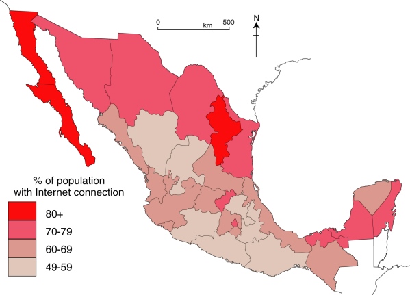
Cyber-connectivity in Mexico, 2015. Data: GCE 2015. Cartography: Geo-Mexico
At state level (map), Baja California Sur led the way in terms of Internet users (84% of respondents claiming access to the Internet), followed by Nuevo León (81.5%) and Baja California (80.4%). (Note that the likely margin of error in results is plus or minus 4%.)
Guerrero is at the other end of the scale, with just 49% of residents online. After last-place Guerrero came Zacatecas, where 53% were connected, and Oaxaca with 55%.
Most Internet users in those three states used a desktop computer to connect. On average, most Internet users spent an hour or two a day online and social networks were the most popular destination for 20% of respondents. Facebook led the way among those networks with 74%, followed by WhatsApp with 12% and Twitter with 7%.
Another question in the survey asked which was the most trustworthy source for information: the Internet, television or newspapers. The Internet won with 28%, television came second with 25% and newspapers trailed with 24%. Frederico Berrueto Pruneta, general manager of GCE, asserts that, “What we are seeing is a very clear tendency where the Internet has won the battle over television, which had already won against newspapers”.
- Full Report (Spanish, pdf): Connectivity in Mexico in 2015
Related posts:
- How globalized is Mexico? (Aug 2013)
- The internet in Mexico: is there a digital divide? (Jun 2011)
- Mexico’s internet connections and e-commerce (May 2014)
- The information divide in Mexico: internet access by state (May 2014)
- The important role of telenovelas and historietas as forms of communication in Mexico