Alexander von Humboldt’s visit to Mexico, 1803-1804

 Other  Comments Off on Alexander von Humboldt’s visit to Mexico, 1803-1804
Sep 292016
 

Alexander von Humboldt‘s visit to Mexico began in Acapulco on March 22, 1803, and lasted for almost a year. (He left Mexico via Veracruz for the USA on March 7, 1804.) In his year in Mexico, Humboldt had been incredibly busy. He had measured, recorded, observed and written about anything and everything, with remarkable industry and accuracy. He had climbed mountains, burned his boots on active volcanoes, descended into mines, recorded geographical coordinates, and collected numerous specimens and antiquities. Humboldt’s Political Essay on the Kingdom of New Spain was the first systematic scientific description of the New World. It appeared in 1811, and marked the birth of modern geography in Mexico. His figures and ideas were used and quoted by writers for many many years.

Humboldt had also drawn a large number of maps, drawings and sketches and it can rightly be claimed that the modern era of Mexican map-making began with Alexander von Humboldt, and was then developed further later in the 19th century by cartographers such as Antonio García Cubas.

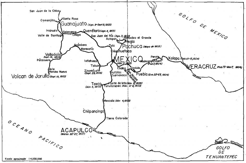
Humboldt's route in Mexico

Humboldt’s route in Mexico. Click to enlarge

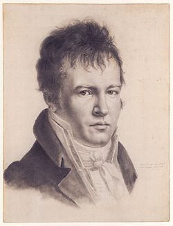
Alexander von Humboldt (Self-portrait c1814)

Alexander von Humboldt (Self-portrait c1814)

The map above shows the route followed by Humboldt during his time in Mexico. The map comes from the book La obra de Alexander von Humboldt en México by Rayfred Lionel Stevens-Middleton  (Mexico D.F.: Instituto Panamericano de Geografía e Historía, 1956). This hard-to-find work is a comprehensive account of Humboldt’s time in Mexico and of his significance for the development of what the author refers to as “modern geography”.

The map of Humboldt’s route in Mexico includes his various side trips such as those to Jorullo Volcano and Santa María Regla.

Humboldt was keen to see Jorullo Volcano, since it was a rare example of a brand new volcano, one of only a handful of volcanoes that have emerged on land anywhere in the world in historic times. Jorullo first erupted on 29 September 1759 and activity continued for 15 years until 1774. Two centuries later, and about 80 km (50 miles) away, Paricutín Volcano burst into action for the first time, in a farmer’s field in 1943.

Santa María Regla, in the state of Hidalgo, about an hour’s drive north of Mexico City, is the best known location in Mexico for basalt columns. The columns, up to 40 meters tall,  are attractively located on the side of a canyon, with a waterfall tumbling over some of them:

Despite only seeing a relatively small part of the country (New Spain as it then was), Humboldt was able to make some generalizations about geography in general, and Mexican geography in particular, that have stood the test of time remarkably well. For example, he was the first to describe the vertical differentiation of climatic and vegetation zones in Mexico. Writing in 1811, he proposed the terms tierra caliente, tierra templada, and tierra fría, terms still widely used by non-specialists today:

Related posts:

Note: this post was first published on May 7, 2012.
Sep 262016
 

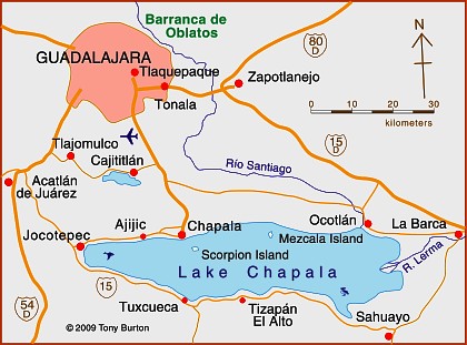
Lake Chapala is Mexico’s largest natural lake. On the geological timescale of millions of years, all lakes are temporary features on the earth’s surface. Once formed, natural processes begin to fill them in and/or to drain them.

Map of Lake Chapala, Jalisco, Mexico. All rights reserved.

Lake Chapala resulted from drastic earth movements, accompanied by earthquakes and faulting which occurred some twelve million years ago. Lake Chapala collected on the floor of a rift valley. Movements along the parallel systems of faults that caused the rift valley still occur today. Evidence for this continued movement can be seen in the cracked or displaced walls of some local buildings.

Given its advanced age, it is not surprising to discover that Lake Chapala was once (thousands of years ago) much larger. In fact, though no-one has so far proven it beyond doubt, it may have been immensely large, covering an area seven times its present area, with a correspondingly long shoreline. At a later stage in its history, it became the deepest lake of an interconnected series of lakes which flooded the valley floors where the towns of Jocotepec, Zapotitan, Zacoalco and Sayula are today. The present Lake Chapala is thus probably only a small remnant of the original version.

The lake is under heavier pressure than at any time in its existence. Local towns and the nearby city of Guadalajara see it as an inexhaustible supply of domestic and industrial water. Tourists see it as a recreation resource, and the thousands of foreign retirees who have settled on its shores see it as a major reason for the area’s beneficial climate.

A case study of ‘residential tourism’ in the villages on the northern shore of Lake Chapala is discussed in chapter19 of Geo-Mexico: the geography and dynamics of modern Mexico.

The levels of flow of the River Lerma, the only river of any size entering the lake, are crucial to the health of the lake. In recent years, demands for Lerma water have multiplied many times over, principally for farms in neighboring states, but also for industries. All the other rivers entering the lake are much smaller and, with rare exception, flow into the lake only a few times a year during the rainy season. The hydrology of Lake Chapala is discussed in chapters 6 and 7 of Geo-Mexico: the geography and dynamics of modern Mexico.

The good news is that Lake Chapala was recently declared an Internationally Important Wetland by the Ramsar Convention, joining a large global network of similarly important wetland sites. The 13th International Living Lakes Conference was held in Chapala, March 22-25, 2010.

This is an edited excerpt from Tony Burton’s Western Mexico, A Traveller’s Treasury (4th edition) .

Which are the best states in Mexico for doing business in 2016?

 Mexico's geography in the Press  Comments Off on Which are the best states in Mexico for doing business in 2016?
Sep 232016
 

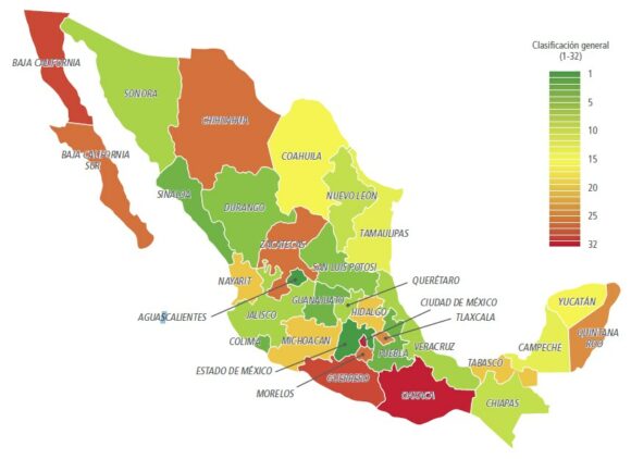
A study just released by the World Bank and the International Finance Corporation, Doing Business en México 2016, compares Mexico’s 32 states for the paperwork, time and costs associated with four major indicators: opening a new business, obtaining construction permits, registering industrial property rights and the resolution of commercial disputes.

The report concludes that the seven best states in which to do business are Aguascalientes, the State of Mexico, Colima, Puebla, Sinaloa, Guanajuato and Durango, all of which offer a better performance than the average for OECD high income countries.

doing-business-2016-fig-1-2

Overall ranking for Doing Business in Mexico 2016 (Source: Fig 1-2 of World Bank Report)

The three states that have advanced the most towards implementing international best practices since 2014 are Puebla, Jalisco and the State of México.

The map shows the rank order of states for doing business, from green (the best) to red (the lowest ranking). Unlike many maps of state-by-state performance, this map does not show any evidence for the north-south divide we have repeatedly commented on in the past.

Related posts:

Sep 192016
 

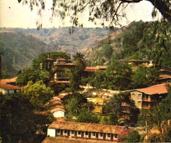
In its day, the San José Purua spa-hotel in Michoacán was world-famous. Opened in the early 1940s, it was the epitome of luxury living. European chefs cooked for the guests. Cabaret and touring acts from all over the world performed in its small night club. An on-site bowling alley provided some entertainment for the younger set. The hotel’s popularity led to the access road, complete with its “La Curva de la Gringa“, being paved for the first time in the mid 1940s. One writer mentions that he saw cars with license plates from no fewer than eight different countries in the hotel’s car park—all at the same time!

San José Purua spa hotel (from an early brochure)

Guidebooks of the time all extolled its virtues, and its peculiarities. For example, this is how Sydney Clark, in “Mexico Magnetic Southland” (1944), described the hotel:

“The hotel, designed in a curious arc with a high bridge leading to the comedor (dining room) is located on a narrow shelf of land on the side of the extremely deep gorge of the Tuxpan River. To beautify the setting, and also for utilitarian reasons, the management has planted no less than fifteen thousand orange trees on the gorge-side, and along with these some coffee trees. There are two large swimming pools with warm radioactive water gushing into them all the time directly from the cliff. It oxidizes in the open air within a few minutes and turns to an odd café au lait color so that the pool is always brown. However, it is no whit less clean than any spring fresh from the earth, and the curative properties are said to be extremely potent.”

Sadly, the San José Purua hotel ran into ownership and management problems and is now but a poor shadow of its former self, though the grounds and pools can still be admired. Several attempts have been made to relaunch the hotel as a luxury resort, but so far none has succeeded.

If you want to overnight or vacation in this magnificent part of Mexico, the best place by far is slightly further down the valley, at the Agua Blanca Canyon Resort, a charming, small hotel with just 20 rooms set in stunning scenery, with its lawns overlooking the deeply carved valley of the River Tuxpan.

This is a geographer’s delight! Waterfalls, rock formations, the meanders of the Tuxpan River, steep canyon slopes… what more could one want? This was one of the first locations in Mexico where high school students were actively engaged in geography fieldwork investigations thirty years ago.

In February 2010, a short distance upstream, the Tuxpan River burst its banks flooding the town of Tuxpan and other nearby settlements in Michoacán.

This is also the region where director John Huston filmed parts of “The Treasure of the Sierra Madre“, starring Humphrey Bogart, in 1947 (he used the San José Purua hotel as his base), but that’s a whole other story.

Sep 142016
 

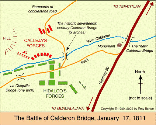
The battle in question is the Battle of Calderón Bridge (Batalla del Puente de Calderón), fought just outside Guadalajara in January 1811 as part of Mexico’s fight for Independence. The decisive battle was waged on the morning of Thursday, January 17.

On one side was Ignacio Allende with some 80,000 ill-equipped and untrained supporters of Father Miguel Hidalgo, the priest who launched Mexico on the road to Independence. On the other side was the numerically much smaller, but professional, Royalist army led by General Félix María Calleja, fighting for the King of Spain .

After six hours of fighting, a stray grenade from the Royalist side landed smack in the middle of the insurgents’ ammunition supplies, resulting in a fearful explosion and fire which brought the battle to a speedy end. Hidalgo and his men fled northwards; the crown troops followed, hot on their heels. The loss of this battle effectively dashed hopes of any quick independence from Spain. Mexico’s  Independence was delayed another ten years, until 1821.

The area where this important battle took place is between Guadalajara and Tepatitla, in the state of Jalisco. A few kilometers beyond Zapotlanejo, the site is clearly marked by a large monument to Father Hidalgo, prompting one to reflect on how often the losers of a battle are commemorated, rather than the winners. The statue overlooks the battlefield: the shallow valley of the Calderón river. In Hidalgo’s time, only a single bridge spanned the river. It was made a national monument in 1932.

Today, three different bridges exist in the general vicinity of the battle and a fourth, not far away, is used by the toll highway to Lagos de Moreno. It’s easy to tell which of the four bridges is the correct one, since it has a plaque commemorating the event!

Curiously, the historically-accepted plan of the battle, reproduced in dozens of scholarly works and hung on display in many museums around the country (still including, to the best of my knowledge, the Regional Museum in Guadalajara) is in fact, upside down! The true orientation of the map was proven (way beyond any reasonable doubt) by Mexican geographer Alma Rosa Bárcenas. In a brilliant and clearly written article, which appeared in the first isue of “Geografía”, published by INEGI in Mexico City in 1986, she clears up the confusion surrounding the exact site of the battle.

She proves, using both field-work and aerial photographs to supplement contemporary battle descriptions which give clues to terrain, slopes and visibility, that the map was drawn “south-upwards”. The map’s “north arrow” actually points due south!

Here is the battle plan the right way round. At last, the battle descriptions make sense! Now, anyone visiting the battle site has a chance to work out for themselves the true dispositions of the troops on both sides, and relive, if only in their imagination, the course of this key battle in Mexico’s War of Independence…

This is an edited version of an article originally published on MexConnect. Click here for the original article

Geo-Mexico: the geography and dynamics of modern Mexico takes an in-depth look at the implications of Mexico’s 1810-1821 War of Independence for the development of transportation and communications systems, as well as migration patterns, settlements and many other aspects of Mexico’s geography and development.

As an added bonus, it has no maps that are upside-down!

How long is Mexico’s coastline?

 Maps  Comments Off on How long is Mexico’s coastline?
Sep 122016
 

This might seem like a very simple question to answer, but actually it is a question which has no definitive answer!

According to the CIA World Factbook, Mexico has 9,330 kilometers of coastline.

According to Mexico’s National Statistics Institute (INEGI), it has 11,122 kilometers of coastline, and that figure apparently excludes the coastlines of Mexico’s various islands.

Amazingly, it is perfectly possible that both figures are ‘correct’.

This is because the length of  a coastline depends in large part on the scale of the map used to make the measurements.  All maps are generalization of reality, and some are more generalized than others. Small-scale maps of Mexico fail to show every bay and headland; measurements made on them will invariably be under the true value. The larger the scale of the map, the closer the measurement will be to ‘reality’, because the map will show more indentations or tiny crenulations.

Theoretically (mathematically), is is  impossible to ever arrive at a definitive length for a coastline since the harder you look (the larger the scale of the map), the more you see, and this carries on indefinitely. This is why it is not at all surprising that different sources offer different distances for the length of Mexico’s coastline (or for particular rivers).

And the moral of this story? In geography, never assume that an apparently simple question has a simple answer!

Related post

Novelist who loved geography set a story in Mexico, which his publisher labeled South America

 Other  Comments Off on Novelist who loved geography set a story in Mexico, which his publisher labeled South America
Sep 082016
 

Several famous writers wrote about Mexico despite having no direct geographic experience of the country.

One of the most famous was  Jules Verne. Verne (1828-1905) popularized geography and was one of the pioneers of travel stories and science fiction.

Many his works have undeniably strong connections to geography, including:

  • Twenty Thousand Leagues Under the Sea, a submarine voyage with Captain Nemo as the enigmatic hero
  • A Journey to the Center of the Earth, in which Prof Lidenbrock and his nephew Axel descend into an extinct volcano in Iceland and discover an underground world
  • From the Earth to the Moon, a vivid forerunner of future space travel
  • Around the World in Eighty Days, where eccentric Englishman Phileas Fogg races round the world to try and win a bet
  • Five Weeks in a Balloon, in which the heroes drift across unexplored areas in Central Asia and The Mysterious Island

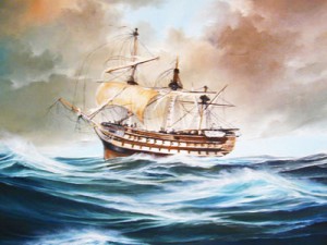
Curiously, one of Verne’s first published stories, was set in Mexico, despite the fact that he had never visited the country. The original title Verne gave the story was North America. Historical studies. The first ships of the Mexican Navy. Meticulous as he was in regards to his geography, Verne was understandably aggrieved when the publisher changed North America to South America without even asking him! The story was first published in 1851, and later reworked as A Drama in Mexico.

The Asia; oil on canvas

The Asia; oil on canvas by Angel Cortellini Sánchez, dated 1896

The plot is set in 1825, shortly after Mexican Independence from Spain (1821). Mexico needed a strong navy to protect its extensive territory, which then stretched as far south as present-day Costa Rica. Antonio de Medina, the first Secretary of War & Navy, had fought at the Battle of Trafalgar in 1805. He persuaded the Mexican Congress to give high priority to the formation of a navy. Foreign interventions later in the century showed how prescient de Medina had been.

Verne’s story tells how the Mexican Navy obtained its first two warships, the former Spanish vessels Asia (later renamed the Congreso Mexicano) and Constanzia, following a mutiny by their crews.

The locales used in the story include:

  • four Pacific coast ports: Acapulco, San Blas, Zacatula and Tehuantepec
  • the villages or towns of Cigualan [Cihuatlán], Chilpanzingo [Chilpancingo], Tasco [Taxco] and Cuernavaca,
  • the caverns of Cacahuimilchan [Cacahuamilpa]
  • the pre-Hispanic site of Xochicalco
  • Popocatepelt [Popocatepetl] Volcano

Read the original: Complete 1876 text in French as a webpage or Alternative complete text in French

If he had never visited Mexico, how did Verne acquire the range of geographic knowledge displayed in this story? Like many other geographers before and after, he relied on qualitative fieldwork—gaining his knowledge by talking to seafarers in his native port of Nantes, and through conversations with Jacques Arago, a Parisian friend who had fought in Mexico’s War of Independence.

Verne’s failure to visit Mexico certainly did not mean that his works had no significance to the people there. Indeed, as social historian William H. Beezley reminds us:

“His novel Around the World in 80 Days, published in 1873, had great popularity in Mexico, where many writers made comparisons between the characters in the novel and the nation’s first international scientific expedition in 1874 that also circumnavigated the globe…”   Mexican National Identity: memory, innuendo and popular culture).

The main purpose of Mexico’s first international scientific expedition in 1874 was to observe, from Japan, the transit of Venus across the Sun.

Verne became the most widely read French author of all time, and one of the most translated authors anywhere in the world.

And what became of the Mexican Navy?

Today, the Mexican Navy (Secretaría de Marina) has over 55,500 personnel, 300 ships and 70 aircraft. Its main tasks are to protect oil reserves in the Gulf of Mexico, assist in the fight against drug traffickers, and aid in hurricane relief efforts.

Original article as it appeared on MexConnect

The geography of Mexico City: index page

 Index page  Comments Off on The geography of Mexico City: index page
Sep 052016
 

This index page has links to our more important posts about Mexico City. Other index pages include:

Administrative

Mexico City background / physical geography / hazards

Water supply / drainage

Sewers / Drainage

Aztecs – Food supply

History / Urban growth / Urban morphology / Housing

Megalopolis?

Mexico City air quality in 1980 (Photo: Tony Burton)

Mexico City air quality in 1980 (Photo: Tony Burton)

Traffic, taxis and air pollution

Metro/subway system

Sustainable Transport / Cable Cars

Airport

Urban revitalization

Other

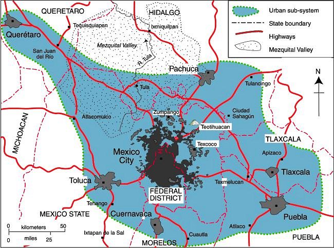
Map of Mexico City urban system:

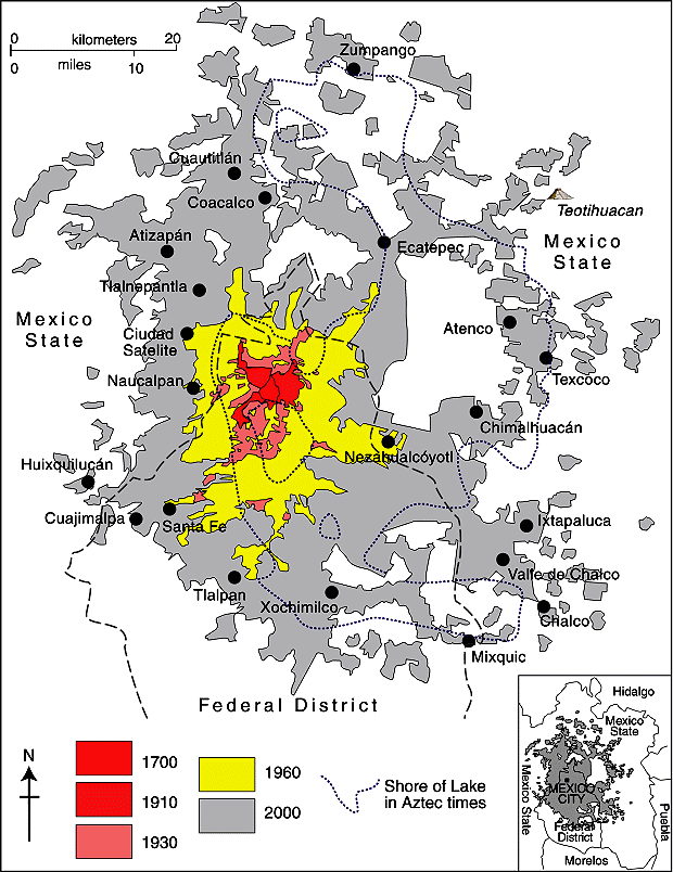
Map of Mexico City urban system

Map of Mexico City urban system. Click to enlarge. (Geo-Mexico Fig 23.1; all rights reserved).

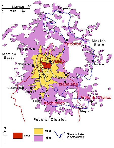
Spatial growth of Mexico City Metropolitan Area:

Mexico City Metropolitan Area (Geo-Mexico Fig 22.2; all rights reserved)

Spatial growth of Mexico City Metropolitan Area (Geo-Mexico Fig 22.2; all rights reserved)

Locations in Valley of Mexico with high incidence of ground cracks:

Mexico City cracks map

Locations in Valley of Mexico with high incidence of ground cracks. Cartography: Tony Burton; all rights reserved.

General posts about Mexico’s urban geography

Hidden Beach, aka Beach of Love, reopens

 Mexico's geography in the Press  Comments Off on Hidden Beach, aka Beach of Love, reopens
Sep 012016
 

Mexico’s famed Hidden Beach (Playa Escondida), aka as the Beach of Love (Playa del Amor), has reopened for limited tourism following a three month closure  for cleaning and restoration work.

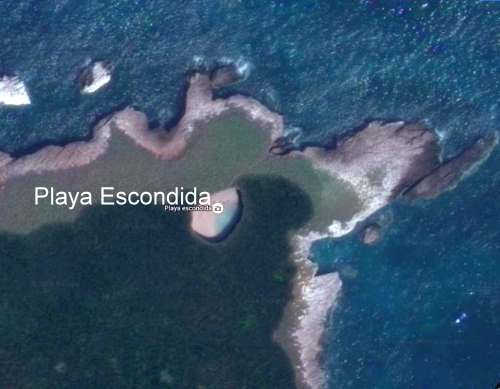
The beach is on one of the small, uninhabited Marieta Islands, in the Marieta Islands National Park, off the west coast of Mexico, and relatively close to the resort of Puerto Vallarta. It is one of Mexico’s most beautiful small beaches, looking from the air (image) like an “eye to the sky”.

Playa Escondida. Source: Google Earth. Scale: The beach is about 30 m (100 ft) long.

Playa Escondida. Source: Google Earth. Scale: The beach is about 30 m (100 ft) long.

In earlier posts, we considered how Playa Escondida (“Hidden Beach”) was formed and also looked at the not inconsiderable downside to publicizing one of Mexico’s most beautiful beaches.

After a study by University of Guadalajara researchers found that local coral was dying and argued that the beach could support no more than 625 visitors a day (compared to the estimated 2500 who visit it on vacation days), federal authorities closed the beach and prohibited access while they considered how best to regulate future visits.

Mexico’s National Protected Areas Commission (Conanp) has now announced new regulations governing visits to the island and to the beach. It is limiting visitors to 116/day, well below the University of Guadalajara figure for carrying capacity of 625/day/.

In addition, no single group may have more than 15 members. No diving is allowed. Fins, face masks and snorkels are all prohibited. Visits have a strict time limit of 30 minutes. The beach, visted by more than 125,000 in 2015, will be completely closed two days each week for maintenance and monitoring.

Only time will tell if these measures will be sufficient to ensure that this particular gem of Mexico’s hundreds of amazing geosites will still be there for future generations to admire and appreciate.

Related posts