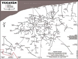
About 1900 one of the densest railroad networks on earth was operating in the Yucatán Peninsula. Between 1870 and 1920 the area experienced an economic boom based on the production of twine from sisal (oro verde or green gold). The numerous plantations in the area needed a way to move the sisal from the fields to processing centers and from there to ports for export. The plantation owners built a very extensive (4500 km) system of narrow gauge railroad system to move sisal as well as sugar and corn.

Map of Yucatan's railways. Copyright Allen Morrison. Reproduced by kind permission (see link to original map near end of this post). Click map for larger version.
The tracks stretched up to 100 km in all directions from Yucatán’s capital, Mérida. Rolling stock and complete sections of track with steel ties were imported mostly from Europe but also from the USA. The small trains were powered by mules, steam engines, electric batteries, and later by gasoline motors. There was no standard design. Several different gauges were in use ranging from 400 to 930 mm (15.7 to 36.6 in).
Foreign competition, the Mexican Revolution, and synthetic fibers brought an end to the sisal boom. Many of the plantations closed in 1930s. Soon small entrepreneurs were providing rail passenger services between the scores of towns in the area. Many families used the small sisal hauling cars as personal transport, powered by a horse or mule. This was far more efficient than animal drawn carts on the rough dirt roads, but required occasional de-railing to allow those going in the opposite direction to pass. Some of the Yucatán’s narrow gauge lines have survived into the 21st century, and some of the former sisal haciendas have reopened as luxury hotels for tourists.
Acknowledgments: Grateful thanks to Allen Morrison, who generously allowed us permission to reproduce his excellent map of Yucatán railways.
Mexico’s transportation systems are the subject of chapter 17 of Geo-Mexico: the geography and dynamics of modern Mexico. Buy your copy today!
Yucatán’s main line railway was not linked to the rest of Mexico until about 1950.
5 Responses to “Yucatán’s independent sisal railroad system”
Sorry, the comment form is closed at this time.
Amazing! I have finally found you! I have traveled around Mexico for 40 years and always on the look-out for a good geography text of Mexico. I found an excellent biophysical text for the Baja (J.Minch & T.Leslie. 1991. “The Baja Highway”) but nothing on the whole country. I am particularly interested in the physical geography. Now that I am retired from my career in geology and later in land use planning, my wife and I travel Mexico every winter with our RV searching out the hidden secrets of Mexico. I can not wait to get your book! Is there any other physical geography text you would suggest? Keep up the good work.
Best Regards,
Alan Pattison
Vernon BC Canada
Wow! What took you so long?? We’re glad you’ve found us, and maybe you’d like to write a guest post or two on some of your experiences for our readers? Thanks for the suggestion of Minch and Leslie, which we hadn’t heard of previously. Unfortunately there is surprisingly little published on Mexico’s physical geography outside of academic journals. There have been several books (English and Spanish) published on plants, though not necessarily focusing on the natural (native) vegetation. We don’t know of any book about the geomorphology or climatology of Mexico, though there are several publications about geology (almost all in Spanish).
We greatly appreciate your good wishes, and hope you will continue to enjoy the Geo-Mexico blog. Tony
PS Of course, if you like Geo-Mexico, you might enjoy my Western Mexico, A Traveller’s Treasury, available from Sombrero Books or amazon.com, as well!
To the best of our knowledge, there is (sadly) no inter-city passenger train service in Mexico now except for the Copper Canyon line from Los Mochis to Creel and Chihuahua. There are some local tourist-oriented trains, however, in locations such as the Yucatan and between Guadalajara and Tequila (the so-called Tequila Expess).
Are there any remnants of track in the Yucatan Standard or Narrow guage that could be made into a ‘preserved line’ ?.
To the best of my knowledge most/all of the track was lifted and removed, but there have since been several proposals to rebuild short sections for tourist trains. One source of more up-to-date information may be the Yucatán Train Museum (Museo de los Ferrocarriles de Yucatán A. C.) in Mérida. The address is given online as Calle 43 s/n, Centro Histórico, C.P. 97160, Mérida, Yucatán. The museum is free, and open Monday-Friday 13:00 to 18:00. Its telephone is listed as (999) 982 23 27 and e-mail as museode-yucatan@hotmail.com. On a related note, there is now a plan to start a modern Trans-Peninsular Train – “The new Trans-Peninsular Light Rail service will include the movement of cargo as well as the transfer of passengers, and trains will reach average speeds of more than 120 kilometers per hour. Routes are planned to cover an estimated total distance of more than 330 kilometers, which will include the areas of Mérida, Yucatán and Punta Venado (near Playa del Carmen in Riviera Maya) in Mexico’s state of Quintana Roo.”