Geography, residence patterns and architecture in the mining town of Santa Rosalía, Baja California Sur

 Other  Comments Off on Geography, residence patterns and architecture in the mining town of Santa Rosalía, Baja California Sur
Mar 092017
 

In a previous post — The re-opening of the giant El Boleo copper mine in Santa Rosalía, Baja California Sur —  we looked at the repeated boom-bust-boom history of the copper mining center of Santa Rosalía on the Baja California Peninsula. The arid peninsula did not offer much in the way of local resources for the construction of a mining settlement. When mining took off, an entire town was needed, virtually overnight. Almost all the materials necessary for the construction and exploitation of the mines and for building the houses and public buildings had to be imported, primarily from the USA.

As the town grew at the end of the nineteenth century, a clear geographic (spatial) segregation developed, which is still noticeable even today:

  • Workers’ homes were built on the lowland near the foundry and port
  • Higher up the slope was the Mexican quarter where government workers and ancillary support staff lived
  • The highest section of town, overlooking everything, was the French quarter.

The contrasts of Santa Rosalía at this time were well summed by María Eugenia B. de Novelo:

“Santa Rosalía was a place of clashing contrasts and situations. It had a scarred backdrop of copper hills, a black-tinted shore, French silks, fine perfumes, crystal, Bordeaux wines and Duret cooking oil, sharing the scene with flour tortillas, giant lobsters, abalone and chimney dust.”

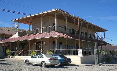
The French quarter has retained its distinctive architecture to the present day. At one end is the Hotel Francés, opened in 1886, which has an incredibly stylish period interior and still operates today.

Hotel Francés, Santa Rosalía

Hotel Francés, Santa Rosalía. Photo: Tony Burton

The gorgeous architecture of many of the homes of the French quarter is reminiscent of New Orleans. Beautiful wooden houses stand aloof on blocks with porches, balconies and verandas, competing for the best view over the town below. Wooden homes are decidedly unusual in this part of Mexico, which was never forested, and are, indeed, rare almost everywhere in the country. There are so many wooden homes here that Santa Rosalía has long had its own fire department, just in case!

At the other end of the French quarter are the former mining offices, now the Museo Boléo, an interesting museum where interior details are little changed from a century ago. Standing in the main hall, it is possible to imagine the hustle and bustle of former days, as clerks work feverishly to keep up with their superiors’ numerous demands. The mining company attracted workers from far afield. Three thousand Chinese workers arrived, settling the districts still known as La Chinita and Nuevo Pekin.

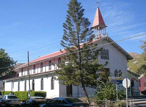
The most conspicuous landmark in the main part of town remains the former foundry, no longer open to the public. The next most conspicuous landmark is the church of Santa Bárbara. There are serious doubts as to who designed this unusual church, assembled out of pre-fabricated, stamped steel sheets or plates. Most guidebooks attribute the church to Gustave Eiffel, the famous French architect responsible for the Eiffel Town in Paris. According to this version, Eiffel’s design won a prize at the 1889 Universal Exposition of Paris, France, and was originally destined for somewhere in Africa. It was later discovered in Belgium by an official of the Boleo mining company, who purchased it and brought it back to Santa Rosalía in 1897.

The church of Santa Rosalía

The church of Santa Rosalía. Photo: Tony Burton.

The latter part of the story may be correct, but research by Angela Gardner (see Fagrell, 1995) strongly suggests that the original designer was probably not Eiffel but is far more likely to have been a Brazilian, Bibiano Duclos, who graduated from the same academy as Eiffel in Paris. Duclos took out a patent on pre-fabricated buildings, whereas there is no evidence that Eiffel ever designed a pre-fabricated building of any kind. Whoever designed it, it is certainly a unique design in the context of Mexico, and well worth seeing.

Other well-preserved buildings dating back to the heyday of the town’s success include the municipal palace or town hall (formerly a school designed by Gustave Eiffel), the Central Hotel, the DIF building, the Club Mutualista, the Post Office and the Mahatma Gandhi library, currently being restored. The library is in Parque Morelos, which is also the last resting place for a Baldwin locomotive dating back to 1886.

If walking around town looking at the architecture makes you hungry, try the French pastries (and Mexican sweet breads) from the Panadería El Boleo on the main street. With slight hyperbole, Panadería El Boleo boasts on its wall of being the World’s most famous bakery. Expect to queue, but enjoy the smells of fresh baked goods while you wait.

The distinctive history, architecture (and pastries) of Santa Rosalía, assuming they are conserved, should prove in the future to be an excellent basis for the development of cultural tourism to supplement the ecotourism and adventure tourism already in place.

Sources:

Want to read more?

Note : This post was first published 11 October 2011.
Mexico City declares public markets to be Intangible Cultural Heritage

 Other  Comments Off on Mexico City declares public markets to be Intangible Cultural Heritage
Aug 222016
 

Mexico has some of the finest markets in the world. The variety of produce and other items sold in markets is staggering. But not all Mexican markets are the same. The two major groups are the permanent markets (mercados), usually housed in a purpose-built structure and open for business every day, and the street market or tianguis, usually held once a week.

Earlier this month, Mexico City passed legislation that gave the city’s 329 public markets Intangible Cultural Heritage status, and provided additional funding to ensure that their traditional activities are maintained for future generations.

Some of the markets are traditional, mixed markets, others are specialized. Between them, they are used on a regular basis by almost half of Mexico City’s residents and provide more than 280,000 jobs. The Mexico City commission established to preserve these traditional spaces and their practices has been allocated a budget in 2017 of $200,000,000 pesos (about $11 million).

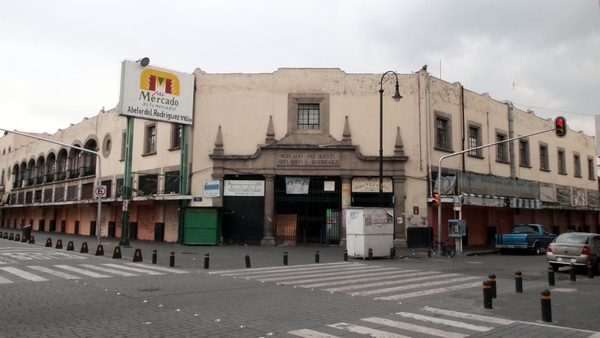
Abelardo L. Rodriguez Market. Credit: Wikimedia. Creative Commons.

Abelardo L. Rodriguez Market. Credit: Wikimedia. Creative Commons.

Beyond their regular role as a trading place, many of the markets in Mexico City have additional claims to fame. For example the La Paz market in Tlalpan in the southern part of the city occupies an architecturally impressive building, while the Abelardo L. Rodríguez market in the downtown area has fine decorative murals painted by students of Diego Rivera.

Related posts:

Sep 102015
 

We have seen numerous examples in previous posts of Mexico’s astonishingly diverse attractions for international tourism. Having succeeded in attracting mass tourism (e.g. Cancún, Ixtapa, Huatulco), Mexico has sought to diversify its tourism appeal by developing niche markets for visitors with special interests, such as cuisine, adventure tourism, historic sites and health-related holidays.

Mexico’s tourism development agency, FONATUR, recently announced it is seeking help from Spain’s leading cultural tourism firm, Paradores de Turismo, to establish a network of Paradores (luxury hotels in historic buildings) in Mexico. Frequent travelers to Spain will be more than familiar with the Paradores system there which offers visitors the chance to stay in some unique historical buildings without sacrificing too many creature comforts.

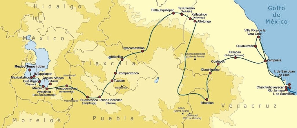
Route followed by Cortés, 1519-1521. Credit: Wikimedia Commons.

Route followed by Cortés, 1519-1521. Credit: Wikimedia Commons. Click to enlarge.

In Mexico, a “History Tourism Plan” is being developed by FONATUR and the Federación de Haciendas, Estancias y Hoteles Históricos de México. In the first stage, an inventory will be compiled of the best existing haciendas, monasteries and other historic buildings that already are, or could be converted to, hotels. At the same time, experts will be discussing which “routes” offer the best combinations and provide most interest to tourists. Routes will be developed to highlight specific themes.

The first route to be proposed is The Route of Cortés, linking properties in five states: Veracruz, Puebla, Tlaxcala, State of Mexico and the Federal District (see map). This is a timely idea given that the 500th Anniversary of the arrival of Cortés and his journey to central Mexico comes in 2019.

Related posts:

May 042015
 

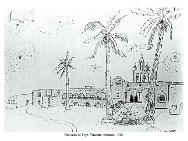
The Haciendas of Mexico: An Artist’s Record, by Paul Alexander Bartlett, first published in 1990 and now available as a free Gutenburg pdf or Epub, is a great starting point for anyone interested in the history, economics, art and architecture of the hundreds of colonial haciendas which still grace Mexico’s rural areas. Bartlett made one of the earliest artistic records of more than 350 of these haciendas, dragging his family around the country for years as he obsessively explored lesser-known places. The photographs and pen and ink illustrations in his outstanding book were made on site from 1943 to 1985.

Geo-Mexico is reader-supported. Purchases made via links on our site may, at no cost to you, earn us an affiliate commission. Learn more.
bartlett-hacienda-1

Pen-and-ink drawing of Hacienda de Teya, Yucatán, by Paul Bartlett.

Bartlett’s hacienda art work has been displayed at the Los Angeles County Museum, the New York City Public Library, the University of Virginia, the University of Texas, the Instituto Mexicano-Norteamericano in Mexico City, and at the Bancroft Library, among other places.

Paul Alexander Bartlett (1909-1990) attended Oberlin College and the University of Arizona, before studying art at the National University of Mexico (UNAM) and in Guadalajara. He was an instructor in creative writing at Georgia State College, Editor of Publications at the University of California Santa Barbara (1964-70) and wrote dozens of short stories and poems. His books include the short novel Adios, mi México (1983), and the novel When the Owl Cries (1960).

Writing must run in the family. Bartlett’s wife was the well-known poet and writer Elizabeth Bartlett (1911-1994). The couple met in Guadalajara in 1941 and married two years later in Sayula. Their son Steven James Bartlett is a widely published author in the fields of psychology and philosophy.

In the foreward to The Haciendas of Mexico: An Artist’s Record, novelist James Michener writes that:

I first became aware of the high artistic merit of Paul Bartlett’s work on the classic haciendas of Old Mexico when I came upon an exhibition in Texas in 1968. His drawings, sketches, and photographs evoked so effectively the historic buildings I had known when working in Mexico that I wrote to the architect-artist to inform him of my pleasure.”

Gisela von Wobeser observes, in her introduction, that,

When Bartlett began his hacienda visits in the 1940s, he found many of the hacienda buildings in ruins, exposed to the ravages of time and vandalism. Buildings had been converted into chicken coops, pigsties, public apartments, and machine shops. Others served as sources for construction materials, from which were scavenged rocks, bricks, beams, and tiles for the habitations of the local population. In some cases the destruction was total: All the hacienda’s structures were removed, and only the name of the place alluded to the fact that a hacienda had ever existed there.

At other haciendas, buildings were adapted to new uses. They were transformed into hotels, resorts, government buildings, barracks, hospitals, restaurants, and schools. The exterior of the buildings were generally left intact; interiors were completely changed.

The best—preserved hacienda buildings were those that continued to function as country properties or vacation homes. In these, Bartlett often found furnishings and utensils from the epoch of Don Porfirio, surrounded by the old traditions of Mexican country life.”

von Wobeser makes the useful distinction between three types of hacienda: those where grains were the main output, those specializing in cattle-rearing, and those for sugar-cane cultivation and processing.

The book describes haciendas in almost every state of the Republic. A handy map and list are provided of which haciendas are located in each state. There are more than 100 pen-and-ink illustrations and photographs in total in the book, which is arranged in seven chapters:

  1. The Hacienda System
  2. Through the Eyes of Hacienda Visitors
  3. Hacienda Life
  4. Fiestas
  5. Education
  6. The Revolution
  7. Mexico Since the Revolution

The accompanying text, written from a non-specialist perspective, is always lively, informative and interesting. The style of illustrations is varied, in keeping with the immense variety of haciendas that the author explored and sketched.

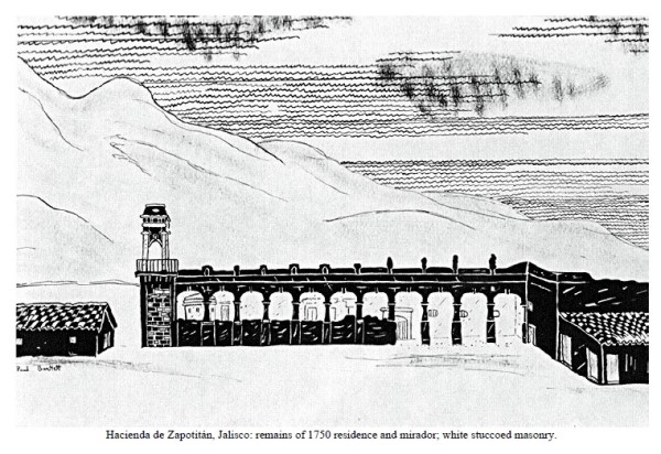
bartlett-hacienda-zapotitan

Pen-and-ink drawing by Paul Bartlett of Hacienda de Zapotitán, Jalisco

Coincidentally, the hacienda of Zapotitán in Jalisco (see illustration above), located close to Jocotepec and Lake Chapala, is the first hacienda to be featured in the on-going series of articles by modern-day hacienda explorer Jim Cook. Jim spends countless hours researching old haciendas, and regularly goes exploring with friends to see what is left on the ground today. His descriptions and photographs are easily the best contemporary accounts of the haciendas in western Mexico.

All in all, this is a really useful addition to the literature about Mexico’s haciendas, one guaranteed to answer many of the questions and doubts that visitors to Mexico often express about just how haciendas functioned and what working and living conditions were like, both for the owner’s family and the workers.

An archive of Bartlett’s original pen-and-ink illustrations and several hundred photographs is held in the Benson Latin American Collection of the University of Texas in Austin. A second collection of hacienda photographs and other materials is maintained by the Western History Research Center of the University of Wyoming in Laramie.

Want to visit some haciendas?

Chapter 9 of my Western Mexico, A Traveler’s Treasury (2013) focuses on the “Hacienda Route” to the south and west of Guadalajara, with an itinerary that includes visiting several haciendas within easy reach of the city.

Related posts:

A new airport for Mexico City

 Mexico's geography in the Press  Comments Off on A new airport for Mexico City
Sep 032014
 

The Mexico City Benito Juárez International Airport handled 31.5 million passengers in 2013, but is operating at near capacity. To ease its congestion, the federal Communications and Transportation Secretariat (SCT) has announced plans to expand the airport eastwards, by annexing 5500 hectares of adjacent federal land bordering Lake Texcoco. The expansion will take several years to complete.

A long-term 9.2-billion-dollar master plan for the airport, with two main phases of construction, was developed by engineering consultancy Arup.

Earlier this week during his second state-of-the-nation address, President Enrique Peña Nieto announced that the winning proposal for designing the new terminal building that forms an integral part of the first phase was submitted by UK-based architect Sir Norman Foster and his Mexican associate Fernando Romero, Carlos Slim’s son-in-law, in association with Netherlands Airports Consultants.

Peña Nieto described the new airport as “the biggest infrastructure project in recent years… and one of the biggest in the world.” He emphasized that his administration was not adopting the easiest short-term path, but “choosing the responsible path”, adding that a project of this scale would inevitably extend well beyond his time in office.

He expected that the new airport would boost tourism, allow more airlines to serve Mexico City, and also help to regenerate an area that has previously suffered severe environmental degradation.

The winning design for the iconic new terminal takes the shape of an “X”, incorporates national symbols in its details, and offers ample space for airport operations, passenger services and exhibitions. The architect is confident that the new airport will be the most sustainable airport in the world, and exceed LEED platinum standards, the highest level of LEED certification.

The first stage, due to be concluded by 2020, involves construction of a new terminal building, control tower and all the infrastructure for operating two runways simultaneously, handling up to 50 million passenger movements a year. Initial work on drainage and foundations will begin later this year. The first phase will generate an estimated 50,000 direct jobs and 160,000 jobs in total.

By 2050, a second phase would have added four more runways and more than doubled the airport’s capacity to 120 million passenger movements.

Record passenger levels in Mexican airports

During the first five months of 2014, Mexico’s airports registered 26,797,688 passenger movements (about 45% international, 55% national), a new record, and 10.8% more that for the same period in 2013. Aeroméxico, the nation’s flagship carrier, accounted for 35.3% of all passenger movements in Mexico, followed by Interjet (23.4%), Volaris (23.3%) and VivaAerobus (12.5%). Aeroméxico recently added several new routes, including links from the northern industrial city of Monterrey to Aguascalientes, San Luis Potosí, Cancún, Puerto Vallarta and Los Cabos.

Related posts:

The urban regeneration of Barrio Antiguo in Monterrey

 Updates to Geo-Mexico  Comments Off on The urban regeneration of Barrio Antiguo in Monterrey
Oct 142013
 

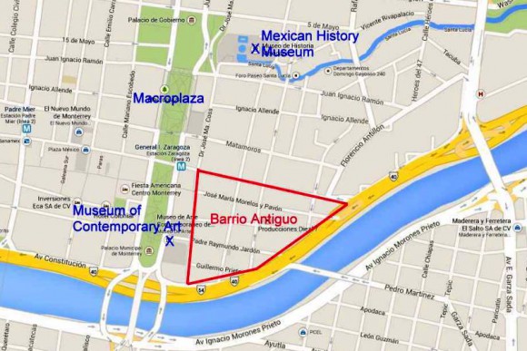
The city of Monterrey in Nuevo León has begun an urban regeneration scheme to rejuvenate one of its oldest sections, Barrio Antiguo (see map below).

Location of Barrio Antiguo, Monterrey.

Location of Barrio Antiguo, Monterrey. (Base: Google maps)

Barrio Antiguo is the area to the east of the Macroplaza. It is bounded to the south and east by Avenida Constitución, to the west by Calle Doctor Coss and to the north by Calle Padre Mier.

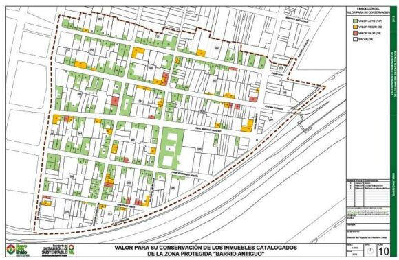
Earlier this year, city authorities, with assistance from the Nuevo León state government, published an online Catalog of Buildings of Historic and Artistic Importance in Barro Antiguo, which will form a basis for future planning decisions about any changes of land use in the area. [To view the entire catalog, scroll down in the center frame on that page.]

The Catalog includes a series of historic maps, from 1765, 1791, 1846, 1865, 1922, 1933 and 1947 respectively, as well as modern maps showing the location of all individual properties in Barrio Antiguo, color-coded to show their importance in terms of conservation and restoration efforts.

Conservation value of buildings in Barrio Antiguo, Monterrey

Conservation value of buildings in Barrio Antiguo, Monterrey (green=high, yellow=medium; red=low; white=no value)

The first phase of the urban regeneration scheme (called “Nuevo Barrio Antiguo”) includes a “paint job” in which all the buildings in the Barrio’s 16 blocks (manzanas) will be repainted in pastel colors. Owners can choose from a palette of pastel colors that has been predetermined as being in keeping with the historic and architectural characteristics of the area. Click here for the approved colors, complete with color swatches, and the matching paint names for different manufacturers.

During the first phase, new street signs will be installed, as well as tiles highlighting associations to famous people who lived or worked in the Barrio Antiguo. A second phase will restore sidewalks, add new street lighting, and involve public consultation about creating cultural and recreational space. Some streets would also be pedestrianized. Planners would seek to ensure that a wide mix of land uses is retained in the area, including residential, and that the area becomes attractive to visitors and tourists. The accessibility of Barrio Antiguo would be boosted if (or when) Line 3 of the city’s Metro system is built, since its proposed route would start near Barrio Antiguo and run 7.5 kilometers to the Metropolitan Hospital.

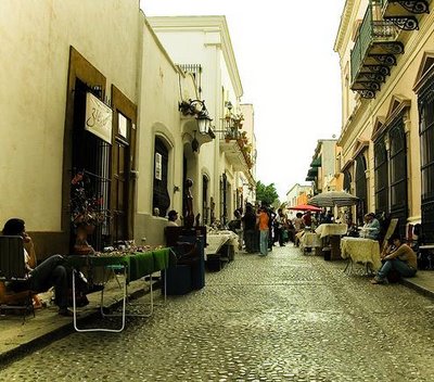
Barrio Antiguo, Monterrey

Barrio Antiguo, Monterrey

The Catalog identifies 193 buildings from the 18th, 19th and 20th centuries as being worth preserving, and the catalog entries for individual buildings provide a cross-reference to other listings of historic buildings such as those previously compiled by the National Anthropology and History Institute (INAH) and state-level agencies. The oldest building in Barrio Antiguo apparently dates back to 1765, while La Casa del Campesino incorporates parts of an even earlier building (from 1728). The listed buildings cover a range of architectural styles ranging from what is described as “vernacular north-eastern architecture” to neoclassic and art deco.

As Monterrey has grown, the condition of Barrio Antiguo’s building stock has deteriorated significantly. During the 1990s and 2000s, many buildings were turned into twilight zone businesses such as cafes, bars and nightclubs. La Casa del Campesino has been repeatedly re-purposed over the years, serving at different times as a government building, charity, hospital, and even a short-term emergency shelter following severe floods in 1909.

Not everyone is happy about the regeneration plans. Critics are vocal about the potential interruption to commerce and small businesses, and fear that it will attract land speculators.

In addition, this is not the first time that plans have been hatched to regenerate Barrio Antiguo. Grandiose plans have been announced on several previous occasions but have never come to fruition.

Housing policy in Monterrey

This 2008 paper by Dr. Peter Ward provides an excellent introduction to housing policy in Monterrey Metropolitan Area:

Related posts: