Is the south shore of Lake Chapala in Jalisco or in Michoacán?

 Maps, Mexico's geography in the Press  Comments Off on Is the south shore of Lake Chapala in Jalisco or in Michoacán?
Aug 242022
 

According to Google Maps, the entire southern shore of Lake Chapala belongs to Jalisco, not Michoacán . . .
– Según Google, toda la orilla sur del lago Chapala pertenece a Jalisco, no a Michoacán . . .

The south shore of Lake Chapala according to Google Maps (2022)

Google might want to alert Mexico’s mapping and statistics agency, INEGI, to that ‘fact.’

Google knows best? Not always!!

Sep 262016
 

Lake Chapala is Mexico’s largest natural lake. On the geological timescale of millions of years, all lakes are temporary features on the earth’s surface. Once formed, natural processes begin to fill them in and/or to drain them.

Map of Lake Chapala, Jalisco, Mexico. All rights reserved.

Lake Chapala resulted from drastic earth movements, accompanied by earthquakes and faulting which occurred some twelve million years ago. Lake Chapala collected on the floor of a rift valley. Movements along the parallel systems of faults that caused the rift valley still occur today. Evidence for this continued movement can be seen in the cracked or displaced walls of some local buildings.

Given its advanced age, it is not surprising to discover that Lake Chapala was once (thousands of years ago) much larger. In fact, though no-one has so far proven it beyond doubt, it may have been immensely large, covering an area seven times its present area, with a correspondingly long shoreline. At a later stage in its history, it became the deepest lake of an interconnected series of lakes which flooded the valley floors where the towns of Jocotepec, Zapotitan, Zacoalco and Sayula are today. The present Lake Chapala is thus probably only a small remnant of the original version.

The lake is under heavier pressure than at any time in its existence. Local towns and the nearby city of Guadalajara see it as an inexhaustible supply of domestic and industrial water. Tourists see it as a recreation resource, and the thousands of foreign retirees who have settled on its shores see it as a major reason for the area’s beneficial climate.

A case study of ‘residential tourism’ in the villages on the northern shore of Lake Chapala is discussed in chapter19 of Geo-Mexico: the geography and dynamics of modern Mexico.

The levels of flow of the River Lerma, the only river of any size entering the lake, are crucial to the health of the lake. In recent years, demands for Lerma water have multiplied many times over, principally for farms in neighboring states, but also for industries. All the other rivers entering the lake are much smaller and, with rare exception, flow into the lake only a few times a year during the rainy season. The hydrology of Lake Chapala is discussed in chapters 6 and 7 of Geo-Mexico: the geography and dynamics of modern Mexico.

The good news is that Lake Chapala was recently declared an Internationally Important Wetland by the Ramsar Convention, joining a large global network of similarly important wetland sites. The 13th International Living Lakes Conference was held in Chapala, March 22-25, 2010.

This is an edited excerpt from Tony Burton’s Western Mexico, A Traveller’s Treasury (4th edition) .

Jul 182016
 

The Montebello Lakes National Park (Parque Nacional Lagunas de Montebello) in Chiapas is a 6040-hectare expanse of rainforest, at elevations ranging from 1500 to 1800 metres (5000-6000 ft) above sea level, near the border with Guatemala. The park has 59 small and mid-sized lakes of varying colors. The variations in color include several tones of blue and green, due to differences in mineral content. About a quarter of the lakes are readily accessible by vehicle or on foot, and they are spectacular on a sunny day.

montebello-lakes-chiapas-gov

The park, which is an international RAMSAR wetland site, was the earliest national park to be established in Chiapas, and dates back to 1959. It was formally designated a UNESCO biosphere reserve in 2009.

This short (2 min, 20 sec) postandfly video gives a great overview of the park’s beauty:


Several of the lakes are used for swimming, canoeing, and kayaking. The largest is Lake Tziscao.

Additional attractions within the park include sinkholes (cenotes), caves (Grutas San Rafael del Arco) and two Maya ruins, the most important of which is Chinkultic, whose ruins date back to the third century. That site’s main pyramid, the Acropolis, affords an excellent view over the region.

The nearest city to the Montebello park is Comitán, an hour’s drive to the west. The picturesque city of San Cristóbal de las Casas, a very popular tourist city, is about three hour’s drive from the park in the same direction.

The protection of the lakes does face some issues. They are so close to the Guatemalan border that the area has been a regular staging post for central Americans entering Mexico illegally, hoping to eventually reach the USA.

In recent years, scientists have expressed concern that the lakes are losing their colors and becoming muddy and lifeless. They attribute this to untreated wastewater and agricultural runoff entering the lakes (via the Grande River which flows directly into the lakes) and deforestation of parts of the lake basins.

The Chiapas state Congress called for action in 2015, and has renewed its efforts this year. Proponents of action want a special commission to be set up to coordinate protection and recuperation efforts. Among those working to preserve this amazing treasure in southern Mexico are researchers from several major Mexican universities, including the National University (UNAM) and the Autonomous University of Chiapas.

Related posts:

Jun 092011
 

Peculiar, but true. There are several lakes named Laguna Encantada (Enchanted Lake) in Mexico, but this one is near Catemaco in the Tuxtlas region of the state of Veracruz. Catemaco is famous for its witches, so perhaps one of them cast a spell on the lake, making it behave perversely, its level changing in opposition to all the other lakes in the country?

Laguna Encantada

Laguna Encantada, Veracruz. Photo credit: Hector Reyes

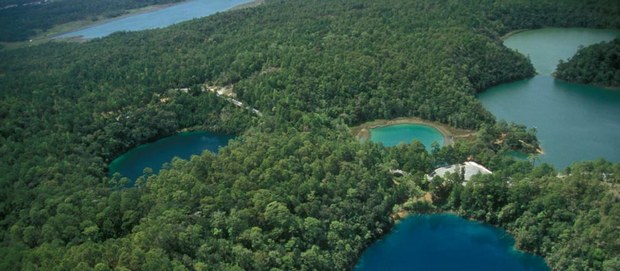
Occupying the crater of an extinct volcano, La Laguna Encantada is a truly beautiful lake, especially near sunrise or sunset. Laguna Encantada is located 3 km northeast of San Andrés Tuxtla. The access road is unpaved. The views are ever-changing on the easy walk of about 1500 meters (slightly under one mile) around its shoreline. As you walk, try counting the butterflies. A study twenty years ago recorded a staggering total of 182 different species in this relatively small area of jungle.

The lake nestles on the southern flank of the San Martín volcano. This dormant volcano is a prominent landmark north-west of Lake Catemaco close to San Andrés Tuxtla. Its crater, 1500 meters across, is at a height of about 1400 meters above sea level, and has two small subsidiary cones inside it.

The basaltic lavas and layers of ash forming the volcano are highly permeable and porous. As a result, despite the heavy rainfall, there are no permanent streams flowing down the upper slopes.

Some distance away from the volcano, though, there are several good-sized lakes including Catemaco and Laguna Encantada. Catemaco is large enough to capture plenty of rainfall to maintain its level. The much smaller basin holding Laguna Encantada (350 meters above sea level), however, does not receive sufficient rain to keep its level high.

Instead, and this is the wonder of La Laguna Encantada, much of its water supply comes from underground. Water that falls on the slopes of the San Martín volcano during the rainy season soaks into the ground and then percolates slowly towards the lake, so slowly that it takes six months to reach it. The result? The lake is unable to sustain its level during the rainy season, but the underground water reaching it in the dry season is more than sufficient to replenish its level. Maybe the witches of Catemaco have something to do with it, but hydrology also plays a part!

Eyipantla Falls

Eyipantla Falls Photo: Tony Burton

Salto de Eyipantla

Only a few kilometers from Laguna Encantada is another wonderful natural sight: the Eyipantla Waterfall (Salto de Eyipantla). The water for the falls comes from the Comoapan river, which drains Lake Catemaco. After heavy rain, the curtain of water at Eyipantla is about 50 meters high and 20 meters wide. The sunlight playing on the water creates a dazzling display of magical colors. The Tuxtlas region has been the setting for numerous movies and commercials and the impressive Eyipantla Falls have starred in many of them. The unusual name, Eyipantla, reflects its three chutes of water, and is derived from the Nahuátl words, eyi (three), pantli (trench) and tla (water).

Chapter 4 of Geo-Mexico: the geography and dynamics of modern Mexico discusses Mexico’s diverse climates.  Chapter 5 focuses on ecosystems and biodiversity.  Chapter 30 analyzes environmental issues and trends including the impact of Old World species imported by the Spaniards, current environmental threats, and efforts to protect the environment.  Buy your copy today to have a handy reference guide to all major aspects of Mexico’s geography!

How big is Lake Chapala?

 Other  Comments Off on How big is Lake Chapala?
Jun 012010
 

“How big is Lake Chapala?”

There is no single answer to this question.  It all depends on the reference point in time.

The extent of the former Lake Jalisco (click image to enlarge map)

Some geologists suggest that 40,000 years ago, the Lake’s surface area was seven times its current size and its volume about 200 times greater.  At that time, the Lake towered almost 700 feet above what is now Guadalajara and stretched nearly to Aguascalientes (see map).  The decline of this massive ancient lake resulted from sedimentation, tectonic faulting and the cutting of a fantastic drainage gorge by the Rio Santiago  (see Jack Leyden’s “The geology and geography of Lake Chapala and western Mexico”, on MexConnect.com)

In recent history, the size of the Lake has continued to change dramatically.  In the 19th century, the Lake stretched almost 20 kilometers farther east.  Construction of an 80 kilometer dike and drainage system in 1908 attempted to capture a large portion of the lake for agricultural use.  Through a series of successive floods, partially attributed to the Poncitlán Dam on the Rio Santiago, the lake recaptured the land.  However, the dikes were re-constructed and the land eventually converted to permanent farmland, only occasionally disrupted by flooding.  Environmentalists argue that this has destroyed an important ecological role of this once important marshland.

The size of Lake Chapala has fluctuated significantly in recent decades; from extreme lows in 1954-56, 1992 and 2003 to highs in the 1960-70s and 2005-06.  These dramatic low to high changes can increase the Lake level by 8 meters, its volume by a whopping 800% and its surface area by 100%.   Fortunately, the Lake is at a relatively high level as we approach the 2010 rainy season.

Obviously, answering the question, “How big is Lake Chapala?” is very time sensitive.   In November 2009, Lake Chapala was about 75 by 25 kilometers with a surface area of 1150 square kilometers and a volume of 5.5 billion cubic meters (bcm).

Lake Chapala is sometimes called the largest lake in Mexico, but even this can be questioned.  It is the largest in terms of surface area. But with its shallow depth it is not the largest in terms of volume. The amount of water it holds, even when full to maximum capacity, is only 8.1 bcm.  It trails three reservoirs behind hydroelectric dams: La Angostura (10.7 bcm), Malpaso (9.6 bcm) and Infiernillo (9.3 bcm). But we must remember that the volume of all Mexico’s lakes and reservoirs varies enormously from season to season and year to year.

What about the future?  All lakes are destined to disappear because they all eventually fill completely with sediment.  In the not too distant geologic future, Lake Chapala will be gone.  Speaking of the future, geologic fault systems aligned with Lake Chapala, working with nearby fault systems, will eventually create a large Pacific island from a big chunk of western Mexico containing Puerto Vallarta and Manzanillo.

These topics are discussed in greater detail in previous Geo-Mexico.com posts:

An early scientific account of Lake Chapala, Mexico’s largest natural lake

 Other  Comments Off on An early scientific account of Lake Chapala, Mexico’s largest natural lake
Apr 272010
 

The first detailed scientific account of Lake Chapala was written by Henri Guillaume Galeotti. It was based on a visit to Chapala in February-March 1837, and published in French in 1839.

Galeotti (1814-1858) was born in Paris and  studied natural history at the Establissement Géographique de Brussels, founded in 1830 by Philippe Vandermaelen, a very famous Flemish cartographer. Vandermaelen produced an extraordinary world atlas, published in 1827, with 400 maps in six volumes, covering the entire world at a uniform scale of about 1:1,600,000.

Galeotti arrived in Mexico in December 1835; it turned out to be a visit which lasted several years. Galeotti was primarily a botanist, and was responsible for the first scientific descriptions of scores of plants, including a wide variety of cacti, for which he had a particularly fondness.
In his account of Lake Chapala, Galeotti starts with a detailed description, before providing some personal observations of storms:

“We have observed in the lake the phenomenon of occasional waves (seiches) which are in the habit of lasting plenty of time, with one part of the water remaining calm next to the rough part. This usually occurs at about five in the afternoon. We noted several of these singular effects, on February 27 and 28, and in March of 1837: the weather was calm and the temperature between 18 and 22 degrees Centigrade. The phenomenon is visible on the southern shore and in Tlachichilco and Chapala. The flood water rises from one to four feet (from 33 centimeters to 1.33 meters)…”

“From time to time, very strong whirlwinds or cloudbursts agitate the lake, snatching fish from their hideouts, and hurling them onto the nearby mountains. Some have been found on quite a high mountain near Ixtlahuacan, two leagues from the lake.”

Early map of Lake Chapala (Galeotti, 1837)

Galeotti goes on to provide a rich account of the varied flora and fauna, especially the birdlife, around the lake, including:

“(the) water sheep or pelicans (Pelecanus) which live on the island of Chapala, and fly in flocks of 50 or 60 individuals, at about five in the afternoon, to search for food on the shores, where some little fish called javai are abundant. The pelicans are very fierce and plump, and have white feathers with a yellowish green tint at the tips of their wings.”

“There is a great diversity of fish in the waters of the lake. The whitefish and the bagoc are very well-liked for the table. A great quantity of fish is caught in Easter week. The inhabitants of the vicinity subsist on little else apart from the product of this fishing, for which they prepare by building reed shacks on the shores of the lagoon, and lighting large bonfires between 6 and 7 in the evening to attract the fish.”

All in all, his article is a remarkable achievement for its time, and a true testimony to the powerful pull that Lake Chapala has had on so many foreign visitors.

Source: Galeotti, H. G. 1839 Coup d’oeil sur la Laguna de Chapala au Mexique, avec notes géognostiques. Translations by the author; all rights reserved.
Note:  This is an edited version of an article originally published on MexConnect, and based on chapter 21–“The natural history of Lake Chapala”–of  Tony Burton’s Lake Chapala Through the Ages, an anthology of travellers’ tales (Sombrero Books, 2008) – click here for the original article.

The hydrology of Lake Chapala is discussed in chapters 6 and 7 of Geo-Mexico: the geography and dynamics of modern Mexico. A case study of ‘residential tourism’ in the villages on the northern shore of Lake Chapala is discussed in chapter19 of Geo-Mexico: the geography and dynamics of modern Mexico.

Related posts about Lake Chapala

The eastern end of Mexico’s largest lake, Lake Chapala, is amputated

 Other  Comments Off on The eastern end of Mexico’s largest lake, Lake Chapala, is amputated
Mar 232010
 

In the 19th century, most of the proposed schemes to change the course or nature of the Lake Chapala area were never carried out. Of those that were implemented, the most significant was the construction in 1883 of the Presa Corona. This dam facilitated the construction of a hydro-power plant at the Juanacatlán Falls. Associated irrigation channels allowed much of the Santiago valley to be farmed all year.

Lake Chapala, showing area drained at start of 20th century. Map: Tony Burton. All rights reserved.

At the eastern end of the lake, farmers had tried several times to gain permanent additional land by draining parts of the lakeshore. Calls for more land, and more control over the position of the edge of the lake were renewed following a drought in 1896, and the very low lake level the following year, when the hydro plant had to be taken out of service for lack of water. Engineers decided to build a dam at Poncitlán to regulate the River Santiago and conserve water in times of plenty.

A few years later, in 1904, very high floods following the rainy season made landowners even more unhappy. The inauguration of the Poncitlán dam in 1905 ironically meant that water levels remained high each year for longer than usual in the much-coveted eastern marshes. In several places, including Jamay and La Palma, local landowners constructed dykes to prevent the water from covering their fields. Levées were built along the Lerma and its tributary the Duero.

Manuel Cuesta Gallardo, a native of Guadalajara, had a much bolder vision, which reflected how successfully Europeans had increased their areas of farmland through drainage and reclamation schemes. He convinced President Porfirio Díaz to award him a concession for the 50,000 hectares of land that would be gained by constructing an 80-kilometer-long earth bank from La Palma to Maltaraña, to completely amputate the eastern end of the lake, the area known as the Ciénega of Chapala. The scheme, designed by engineer Luis P. Ballesteros, also involved digging major drainage channels. All the work was done by hand. By 1908, the work was complete.

The following year, disastrous floods overwhelmed the earth banks, destroyed bridges and wrecked crops. Further floods in 1913 caused further damage, but all the dykes were rebuilt by the following year. While the scheme has certainly not prevented occasional flooding, it has increased the agricultural area in the region. But at what cost? Critics say that the delicate ecological balance of the lake was destroyed for ever. The marshland’s natural sponge-like ameliorating effect, soaking up excess rainfall to make it available again in times of drought, was gone for good.

The hydrology of Lake Chapala is discussed in chapters 6 and 7 of Geo-Mexico: the geography and dynamics of modern Mexico. A case study of ‘residential tourism’ in the villages on the northern shore of Lake Chapala is discussed in chapter19. Lake Chapala was recently declared an Internationally Important Wetland by the Ramsar Convention, joining a large global network of similarly important wetland sites. The 13th International Living Lakes Conference is being held in Chapala, March 22-25, 2010.

This is an edited excerpt from Tony Burton’s Lake Chapala Through the Ages, an anthology of travelers’ tales (Sombrero Books 2008)

One of Mexico’s earliest geographers

 Other  Comments Off on One of Mexico’s earliest geographers
Feb 142010
 

José Antonio Villa-Señor y Sanchez, born in Mexico in about 1700, is one of the earliest Mexican geographers. He studied at the College of San Idelfonso in Mexico City, and was later employed in the collection of taxes, becoming comptroller of revenue from mercury (a chemical essential to the refining of silver ores).

He was subsequently appointed cosmographer of New Spain. In this capacity in 1742, he was commissioned by the Viceroy, Pedro de Cebrián y Agustín, Count of Fuenclara, to write a descriptive history and geography to comply with a royal edict from King Philip V of Spain. His works included Teatro Mexicano; Descripción general de los Reinos y Provincias de la Nueva España (1746), Observación del Cometa, que apareció en el hemisferio de México en Febrero y Marzo (1742) and several maps, including one of the Jesuit province of New Spain, from Honduras to California (1754). He died in about 1760.

More than 200 years later, the planners of Ciudad Satélite, an urban development in the northern part of Mexico City, named a street in the Circuito Geógrafos area after him.

Villa-Señor’s descriptions help to paint a wonderful picture of what New Spain was like in the middle of the 18th century. For instance, he describes the city of Guadalajara as having eight plazas; fourteen churches, monasteries and convents; two colleges and a university; two hospitals and a dozen government buildings or public facilities, making it a fine, surprisingly spacious and prosperous city.

Villa-Señor y Sanchez provides us with our earliest description of the marshy areas at the south-east corner of Lake Chapala, which at that time had several small islands. This is the area that was deliberately drained in the early years of the 20th century. The former islands are now visible only as small hills protruding above flat, intensively cultivated farmland.

[This post is an edited extract from Lake Chapala Through the Ages, an anthology of traveller’s tales]

Lake Chapala’s remaining wetlands were recently (4 February 2009) granted Ramsar Protection Status.

To read more about the issues facing Lake Chapala, Mexico’s largest natural lake, see chapters 6, 7 and 19 of Geo-Mexico: the geography and dynamics of modern Mexico.

For more background to Lake Chapala’s issues, read Tony Burton’s series on MexConnect or use that site’s search function.