Apr 092012
 

A recent report from researchers at the National Autonomous University of Mexico (UNAM) and the Metropolitan Autonomous University (UAM) confirms that the height of the water table below Mexico City is dropping by about one meter a year, as more water is pumped out of the aquifer than the natural replenishment rate from rainfall. About 60% of Mexico City’s drinking water comes from wells, with the remainder piped into the city, mainly via the Cutzamala system. The researchers say that up to 65% more water is taken from some parts of the Mexico City aquifer than the amount replaced each year by natural recharge.

As we reported in a previous post – Why are some parts of Mexico City sinking into the old lakebed? – this has resulted in parts of Mexico City sinking more than seven meters (23 ft) since 1891, with implications for water pipelines, drainage systems, building foundations and the city’s metro network, as well as an increased incidence of ground subsidence.

According to this latest research, the clay soil of the former lake bed below the city is sinking by between 6 and 28 cm/yr in most places, with rates in the southeast part of the city (where numerous wells have been drilled in recent years) sinking by up to 35 cm/yr.

How can the problem of sinking ground be resolved?

The report emphasizes the importance of conserving as much green space as possible within the city, to reduce runoff (and demands on the city’s drainage system) while simultaneously recharging aquifers. The three major alternatives, some combination of which is needed to resolve the problem are:

  • introduce more water-saving strategies so that demand does not continue to increase
  • bring more water from outside the Valley of Mexico (this would be costly and unpopular)
  • feed more wastewater back into the underground aquifers via “surface soaks”. As one example, the National Water Commission (Conagua) has announced plans to build a 200-million-dollar wastewater treatment plant (“El Caracol”) that will inject water back into the aquifer after treatment. It would be Mexico’s first ever large-scale reinjection project.

Perhaps not surprisingly, Mexico City residents pay more for their water than users anywhere else in the country, with an average water rate of US$1.23/cubic meter. Elsewhere, the two states sharing the arid Baja California Peninsula also have higher than average rates of $1.05/cubic meter (Baja California Sur) and $0.94/cubic meter (Baja California). The lowest rate in the country, well below the true cost of supplying water, is in Nayarit, and is just $0.25/cubic meter.

Within Mexico City, access to potable water is far from equally/fairly distributed across the city, as revealed by this thought-provoking quote :

In a study of water access in Mexico City, geographer Erik Swyngedouw found that “60 per cent of all urban potable water is distributed to three per cent of the households, whereas 50 per cent of the inhabitants make do on five per cent of the water”. Critical geographers like Swyngedouw ask us to take note of the spatial nature of power imbalances revealed in patterns of city design and growth: “mechanisms of exclusion… manifest the power relationships through which the geography of cities is shaped and transformed.”  [quote comes from page 31 of Nature’s Revenge: Reclaiming Sustainability in an Age of Corporate Globalization ; the reference is to Erik Swyngedouw’s Social Power and the Urbanization of Water: Flows of Power (OUP 2004).]

This grossly unequal distribution of potable water remains a critical problem that successive administrations in Mexico City and the surrounding State of México have done little to resolve.

Related posts:


Greenpeace demands action to clean up Mexico’s surface waters

 Mexico's geography in the Press  Comments Off on Greenpeace demands action to clean up Mexico’s surface waters
Apr 052012
 

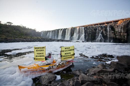
Greenpeace activists chose the Juanacatlán Falls (“The Niagara of Mexico”) for their latest protest to call attention to the poor quality of Mexico’s rivers and lakes. They cited government statistics that show 70% of Mexico’s surface water is contaminated. Most of the pollution comes from industrial dumping, rather than municipal sewage.

It is hard to imagine a better choice. The activists, clad in protective clothing and wearing masks to avoid inhaling toxic gases, paddled kayaks into the River Santiago immediately below the malodorous falls and unfurled banners with slogans such as “Mexican rivers, toxic rivers” (see image).

Greenpeace activists at El Salto de Juanacatlán, 22 March 2012. Photo: Greenpeace.

The activists called on the government to commit to a policy of zero dumping of toxic substances into rivers and lakes by 2020, with sanctions for actions leading to pollution and its effects.

In a coordinated action, thirty NGOs in Jalisco announced the creation of the “Broad Front in Defense of Water and Against Privatization ”, demanding actions towards a fully sustainable use of water. They asked government to take the lead in cleaning up the Santiago River and provide urgent medical attention for residents of communities affected by its high level of pollution (see this blog post). They also called for an end to the privatization of water services.

José Luis Luege, the head of Mexico’s National Water Commission (Conagua), the government body overseeing all Mexico’s water resources, recently presented a portfolio of programs for the country’s 13 water regions which are designed to make Mexico’s water usage sustainable.

Conagua calculates that Mexico currently uses 78.4 million cubic meters of water a year. Of this amount, 66.9 billion cubic meters is taken from surface and underground sources (and is fully sustainable), while about 11.5 billion cubic meters come from the unsustainable use of aquifers, where the rates of abstraction exceeds replenishment. The new programs are designed to reduce and eventually end unsustainable aquifer use, replacing it by a mixture of water-saving programs and by building the necessary infrastructure to obtain more water from sources believed to be fully sustainable.

Related posts:

Will the mighty Colorado River ever reach its delta?

 Other  Comments Off on Will the mighty Colorado River ever reach its delta?
Feb 062012
 

A few months ago, we highlighted the outstanding work of photographer Peter McBride. McBride traveled the length of the  Colorado River from its source high in the Rocky Mountains to its vast delta in the otherwise arid Sonoran desert in northern Mexico where the river emptied into the Sea of Cortés (Gulf of California). Now, McBride has released (on Yale Environment 360) a visually stunning video about his experiences tracing the Colorado River. The last third or so of the video focuses on the Colorado delta region in northern Mexico.

McBride follows the natural course of the Colorado “by raft, on foot, and overhead in a small plane, telling the story of a river whose water is siphoned off at every turn, leaving it high and dry 80 miles from the sea.”

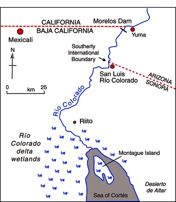
The river enters Mexico (see map below) at the Southerly International Boundary where a gauging station records the river’s discharge. Sadly, this river is one of the most altered river systems in the world.The Río Colorado delta wetlands once created ideal conditions for a rich variety of wildlife. Today, the Río Colorado wetlands have been reduced to about 5% of their original extent, and the potential water supply for the rapidly-growing urban centers of Mexicali, Tijuana, Tecate and Rosarito has been compromised.

Map of the Colorado delta

Map of the River Colorado delta. All rights reserved. Click to enlarge.

Related articles:

Rivers, reservoirs and water-related issues are discussed in chapters 6 and 7 of Geo-Mexico: the geography and dynamics of modern Mexico. Ask your library to buy a copy of this handy reference guide to all aspects of Mexico’s geography today! Better yet, order your own copy…

Maintaining the drains and sewers of Mexico City

 Other  Comments Off on Maintaining the drains and sewers of Mexico City
Jan 312012
 

How is Mexico City’s choking sewer system cleaned? Have you ever wondered who is responsible for the gross job of cleaning the city’s sewer system to help ensure it never gets blocked? Well, we did and were surprised at the answer…

In previous posts, we looked at the history of attempts to drain Mexico City:

and at the construction of a massive tunnel to improve the city’s drainage:

At present, both the water supply system and the sewer systems of Mexico City are managed by a single government entity, the Sistema de Aguas de la Ciudad de México (SACM).

In 2008, the system’s main existing tunnel was shut down for its first maintenance in 35 years. To maintain the drains and sewers, Mexico City relies heavily on its experienced team of divers, all two of them! They are thought to be the only sewage divers in the world. This 2010 interview from the always interesting blog ediblegeography.com with diver Julio Cou Cámara is a mind-opening read.

In his own words, “What we mostly do is maintenance. We repair pumps, we take out debris—we take out bodies of animals, bodies of people, and all the rubbish. There’s so much rubbish in the drainage system, it’s very harmful to us and to the city. People are always wondering why there’s so much flooding in the city. I can tell you that the city floods because of all the rubbish that creates blockages in our drainage system. If we were maybe a bit more conscious about rubbish and we didn’t throw it on the street, we wouldn’t have this many flooding problems in the city.”

Frankly, this challenging job does not sound like much fun: “We work blindly in the black water. It contains animal poo, human poo, hospital waste… any kind of pollution you can think of. All of that is in the sewage water. That’s where we work.”

So, now you know! The sewers of Mexico City would function far worse if it wasn’t for the unsung heroism of workers like Carlos Barrios and Julio Cou Cámara.

(But if a vacancy comes up, please don’t call)

Jan 232012
 

As we saw in an earlier post – Attempts to provide drainage for Mexico City date back to Aztec times – Mexico City has serious drainage problems. Because of the shifting subsoil as the land on which the city was built sinks an average of 10 cm/yr, the main drainage tunnels built years ago no longer have the slope (grade) they need to work efficiently. At least one of the feeder tunnels now slopes in the wrong direction!

This has greatly increased the risk of catastrophic flooding occurring. After years of discussion, authorities decided a few years ago that the only viable solution was to construct another major drainage tunnel to take pressure off the existing system and increase the maximum drainage rates following heavy storms.

The new tunnel, known as the Eastern Drainage Tunnel (Túnel Emisor Oriente), is said to be the world’s largest ever drainage tunnel and should be completed within the next couple of years. It is 7 m (23 ft) in internal diameter (wide enough for a tractor trailer) and can carry up to 150 cubic meters of water a second.

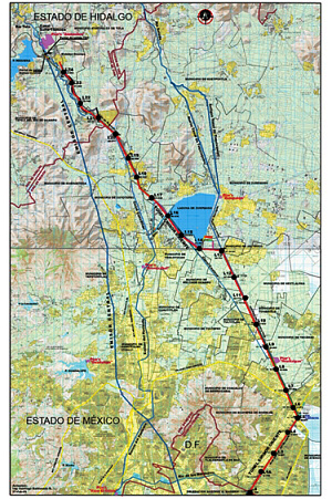
Map of tunnel route

Map of tunnel route; the new tunnel is in red, the existing Central Tunnel is in blue

The tunnel is 62 km (39 mi) long. It starts from the interceptor channel of Río de los Remedios and ends in a treatment plant in Atotonilco de Tula (Hidalgo), close to where the existing Central Drainage Tunnel flows into the El Salto River. Atotonilco receives 725 million cubic meters of water each year carrying 180,000 tons of garbage. Some of the treated water will be piped to the Mezquital Valley Irrigation District in Hidalgo where water usage exceeds natural replenishment rates. The remainder of the treated water will be given additional (tertiary) treatment before being piped into the overexploited underground aquifers to replenish them.

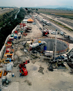
photo of new tunnelThe Eastern Drainage Tunnel construction project is one of Mexico’s largest engineering undertakings ever. The total investment (45% government, 55% private) is almost a billion dollars. Six massive boring machines are working in coordination, each boring a 10km section of the tunnel. The work is challenging, partly because of the varied nature of the rocks (limestone, volcanic rock, sand and clay) and partly because parts of the tunnel are as much as 200m (equivalent to 40 stories) below the surface.

Ventilation shaft of new tunnel

Ventilation shaft of new tunnel

Mexico’s 2011 drought is raising the price of basic foodstuffs

 Mexico's geography in the Press  Comments Off on Mexico’s 2011 drought is raising the price of basic foodstuffs
Dec 052011
 

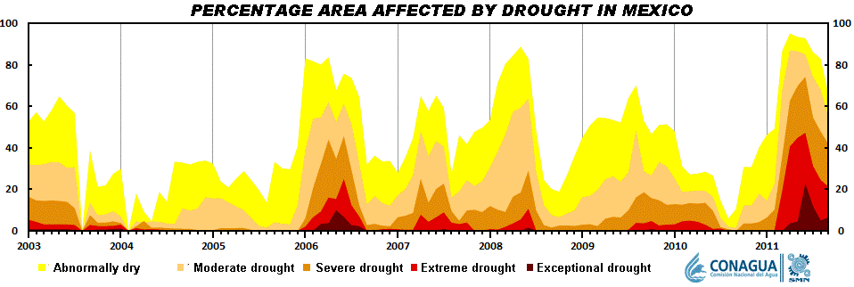
This year’s drought – see Many states in Mexico badly affected by drought is now widely viewed as the worst to occur since modern record-keeping for precipitation began about 80 years ago.

Short-term droughts are not unusual in Mexico. As the graph shows, there is a clear cyclical pattern to the timing of short-term droughts in Mexico. This is because most of the country receives almost all its annual precipitation in just a few months, from May or June (depending on precise location) to September-October.

The scale of the current drought is readily apparent from the graph. This year, far more of the country is affected, and the level of drought is far more severe.

Seasonal drought in Mexico, 2003-2012
Seasonal drought in Mexico, 2003-2012. Click to enlarge.

The drought is having numerous adverse impacts

It is already having an effect on food prices. Several of the basic foodstuffs  making up Mexico’s basic basket of goods for economic indices such as the inflation index, have risen sharply in price in recent months. A shortage of corn has led to a 70% increase in imports of yellow corn from the USA.

Incredibly, Mexico, the home of corn, is now the world’s second largest importer. Corn, as we have noted in previous posts, is a vital ingredient in Mexican cuisine, and is particularly important in the southern half of the country, especially in the more rural and indigenous areas. The shortage of corn has led to a rise in the price of tortillas, a dietary staple in almost all of the country. Tortilla prices have risen up to 18%, many times Mexico’s overall inflation rate of about 3.5%.

The production of chiles, another staple of the Mexican diet, has also fallen due to the drought, by an estimated 40%. In Zacatecas, that state’s 2,500 chile-growers will have produced 120,000 tons of green chile and 62,150 tons of dried chile this year, even though they have only been able to harvest chiles twice this year, rather than the normal four times. The state is the leading source of dried chile in Mexico. The area cultivated for chiles in Zacatecas has also fallen this year, to 31,300 hectares. The decrease in production has had a direct impact on the number of harvesting jobs available, since each hectare of chile cultivation usually means 150 seasonal jobs. The production shortage for chiles will be offset by more imports from Peru and China.

At latest count, 770 municipalities are now suffering from drought, and at least 2.5 million people in 1500 communities are left with insufficient drinking water. In the state of Durango alone, more than one million people are currently experiencing extreme drought, and 149 communities are completely without drinking water.

The long-term outlook is not favorable for these areas since climate change is expected to increase both the frequency and severity of droughts over the next twenty to thirty years.

Related posts:

Many states in Mexico badly affected by drought

 Mexico's geography in the Press, Updates to Geo-Mexico  Comments Off on Many states in Mexico badly affected by drought
Nov 232011
 

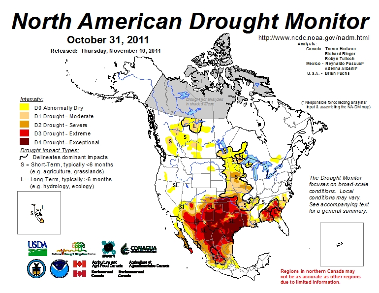
Much of Mexico is currently affected by some degree of drought (see map below). The National Meteorological Service (SMN) reports that September was one of the driest months in some 70 years. All the signs suggest this is the worst year for drought since 1941. The worst affected states are Sonora, Chihuahua, Coahuila, Durango, Nuevo León and Zacatecas. (Paradoxically, some parts of southern Mexico, especially in the states of Oaxaca and Tabasco, have experienced serious flooding in recent months).

In the drought zones, emergency programs are getting underway to provide temporary work for many rural dwellers and to supply potable water to the worst affected settlements. In addition to crop losses, up to one million head of cattle will have been put down by year-end in northern states as a direct result of the drought, since farmers do not have sufficient fodder available to feed them as usual.

While some cattle have been exported to the USA, local meat prices will be driven down by the increase in supply, making many farmer’s livelihoods even more precarious. Many farmers will need federal assistance to overcome this latest crisis.
Areas suffering from drought, October 2011

Areas suffering from short-term and long-term drought, October 2011. Click map to enlarge

Durango faces the worst drought for 100 years

In Durango, water has been provided to 32,691 residents in 10 municipalities, with another 36 municipalities to be supplied in the current phase of emergency assistance. Officials in Durango say it is the state’s worst drought for 100 years, with most larger reservoirs in the state now holding between 20% and 40% of their capacity; one reservoir is already down to less than 10% of its.

Irregular rains over the past few months have done little to replenish reservoirs, leaving farmers in despair. The long-range forecast does not appear to offer them much consolation, with the drought expected to last well into next year.

By mid-September, some parts of Durango had received less than 140 mm of precipitation so far ths year, well below the 425 mm registered for the same period in 2010.  The only hope for local farmers appears to be if late season hurricanes bring far more rain than expected to this region.

The drought news from other states

In Chihuahua, 589 tankers have delivered water to settlements housing 62,000 in 15 different municipalities: Guazapares, Janos, Manuel Benavides, Morelos, Moris, Ocampo, Ojinaga, Urique, Uruachi, Aldama, Balleza, Bocoyna, Guachochi, Guadalupe and Calvo.

In Zacatecas, a “state of emergency” has been declared for 52 of the state’s 58 municipalities. More than 150 communities are seriously affected, especially smaller communities in the municipalities of Fresnillo, Jerez, Guadalupe, Tlaltenango, Nochistlán, Atolinga, Villa de Cos, Genaro Codina and Teúl de Gonzalez Ortega.

Drought has affected 288,000 hectares of rain-fed crops in Guanajuato. The greatest losses are of corn, beans, wheat, sorghum and other grains, with the worst-hit areas located in the northern part of the state. More than a million liters of potable water have been supplied to 18,000 inhabitants living in 133 settlements in the state, located in the municipalities of Atarjea, Doctor Mora, San Diego de la Unión, San Felipe, Santa Catarina, Tierra Blanca, Victoria and Xichú.

Horticulturalists in Sinaloa growing vegetables, grains and fruit for export want 30 million dollars in emergency funds to restore irrigation to 700,000 hectares of productive land. More than 200,000 seasonal jobs are at risk.

Related post:

Mexico’s water resources and water-related issues are the subject of chapters 6 and 7 of Geo-Mexico: the geography and dynamics of modern Mexico. Ask your library to buy a copy of this handy reference guide to all aspects of Mexico’s geography today! Better yet, order your own copy…


Mexico, USA and Canada cooperate to produce monthly drought maps

 Books and resources  Comments Off on Mexico, USA and Canada cooperate to produce monthly drought maps
Nov 192011
 

The North America Drought Monitor (NADM) is a “cooperative effort between drought experts in Canada, Mexico and the United States to monitor drought across the continent on an ongoing basis”. The program began  in 2002 . The NADM is an extension of an earlier version that was limited to the USA.

The NADM combines multiple indices and local information to produce “drought monitor” maps that best reflect the consensus of numerous scientists, some working at state or federal level, and others working in tertiary education and research.

What exactly is a “drought”?

The basic definition of a drought is a prolonged period of abnormally low precipitation. In practice, this means a period when precipitation is significantly less than would normally be expected for the time period under consideration. The amount of precipitation that is “normal” varies greatly from one area to another, and can also vary with the seasons. Low precipitation in a desert would not necessarily indicate a drought! On the other hand, low precipitation in a rainforest almost certainly would indicate a drought. Since most of Mexico experiences a dry season and a rainy season each year, this further complicates the picture. Not only is it important to know how much precipitation falls, but it is also important to know when it falls.

Areas suffering from drought, October 2011
Areas suffering from short-term and long-term drought, October 2011. Click map to enlarge

This definition must be borne in mind when looking at the Drought Monitor maps, as should the seasonality of precipitation throughout most of Mexico, and the distribution of precipitation, which varies greatly from north to south.

The NADM maps show that the drought situation can change quite rapidly from one month to the next. (Use the link above to compare February and March 2011, for example, or March and April 2011).

In a future post, we will take a closer look at the impacts of the drought (shown on the map) that currently affects much of northern Mexico.

Mexico’s freshwater aquifers: undervalued and overexploited

 Excerpts from Geo-Mexico  Comments Off on Mexico’s freshwater aquifers: undervalued and overexploited
Nov 052011
 

Mexico’s groundwater aquifers are a very important resource. About 64% of public water supplies come from wells sunk into aquifers. Mexico City, Monterrey and several other metropolitan areas rely heavily on aquifers. Aquifers also provide about one-third of all the water for agriculture and livestock.

The largest aquifer resource in terms of renewable water availability is in the Yucatán Peninsula, with about a third of the national total. A large portion of the rainfall in the Yucatán seeps into its aquifers; there are virtually no rivers to carry rainwater to the ocean. The states of Chiapas and Tabasco, where rainfall is the heaviest, account for about a quarter of Mexico’s aquifer resource. The next largest sources are the Balsas and Lerma–Santiago basins but each holds less than a tenth of the national total.

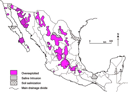
Map of overexploited aquifers and areas of salinization

Overexploited aquifers and areas of salinization (Fig 6-7 of Geo-Mexico; all rights reserved)

According to the National Water Commission, 104 of the country’s 653 identified aquifers are overexploited in that more water is withdrawn each year than is naturally replaced. The velocity of water movements underground can be astonishingly slow; it may take rainwater water tens or even hundreds of years to reach the aquifer it is replenishing. (For a curious case of replenishment rates, see The Enchanted Lake).

The number of overused aquifers has increased rapidly in recent decades from 32 in 1972, to 80 in 1985, and 104 in 2004. When coastal aquifers are over-exploited, seawater seeps in to replenish the aquifer, and eventually the aquifer can become too salty to be used for irrigation. Salt-water intrusion is a significant problem for 17 aquifers located in Baja California, Baja California Sur, Colima, Sonora and Veracruz (see map).

Nearly 60% of the total groundwater extracted is withdrawn from overexploited aquifers. As expected,  the over-exploited aquifers are in the heaviest populated and the most arid areas. Total water extraction exceeds recharge in Mexico City, Monterrey and other large northern metropolitan areas as well as irrigated areas of Sonora, the central northern plateau, the Lerma basin and Baja California.

Related posts:

Mexico’s water resources and water-related issues are the subject of chapters 6 and 7 of Geo-Mexico: the geography and dynamics of modern Mexico. Ask your library to buy a copy of this handy reference guide to all aspects of Mexico’s geography today! Better yet, order your own copy…

Which cities have the best and worst water systems in Mexico?

 Books and resources  Comments Off on Which cities have the best and worst water systems in Mexico?
Aug 182011
 

The Water Advisory Council (CCA), a Mexican NGO specializing in water research, education and policy, has published its 2011 report on Mexico’s water management, sewerage and sanitation. The report looks at data for 50 Mexican cities, each of which has a population in excess of 250,000.

The report —Gestión del Agua en las Ciudades de México (Water Management in Mexican Cities)— uses data for 20 variables to develop the following 10 indicators: drinking water coverage; drainage and sewerage coverage; continuity and extension of services; productivity; metering; physical efficiency; business efficiency; operating income; wastewater treatment; and institutionalization.

In terms of overall performance, the city of León came top, followed by Saltillo, Monterrey, Mexicali, Aguascalientes, Cancún and Tijuana. Of the top six, three (Saltillo, Aguascalientes and Cancún) are managed by private operators, while León, Mexicali and Tijuana are public water systems. There is clearly no discernible difference between the performance of private operators and the best public systems. Towards the bottom of the rankings, all the cities have public water systems. The worst-ranking cities include several in the State of Mexico, as well as others in the south and southeast of the country.

For water quality, the leader was Ciudad Victoria, followed by Colima, Monterrey, León, Torreón, Tepic and Hermosillo. The ten worst were Villahermosa, Cuernavaca, Acapulco, Oaxaca, Xalapa, Chetumal, Chilpancingo, Celaya, Chimalhuacán and Campeche.

For efficiency, the leader was Saltillo, followed by León, Monterrey, Tijuana and Aguascalientes. The least efficient were Ecatepec, Campeche, Villahermosa, Celaya, Chilpancingo and Chimalhuacán.

The report says that where the private sector is involved, the important issues are transparent tenders; clear, balanced and flexible contracts; effective controls to prevent abuse; legal certainty; and effective regulation with stable, long-term regulating agencies.  The authors also emphasize the importance of pricing that reflects costs, and of removing the payment exemptions currently given to government agencies.

The Water Advisory Council argues that the Federal Agency for Environmental Protection (PROFEPA) should be in charge of all water monitoring, though its powers need strengthening to ensure it can fully carry out its mandate.

Could Southern California’s water woes be eased by a desalination plant in Mexico?

 Mexico's geography in the Press  Comments Off on Could Southern California’s water woes be eased by a desalination plant in Mexico?
Aug 042011
 

Southern California water officials are reportedly considering helping to finance a desalination plant in Mexico as a partial solution to their on-going water issues.

A desalination plant proposed by San Diego County Water Authority and Metropolitan Water District of Southern California, and planned for north of the border in Carlsbad (San Diego County) has been tied up in lawsuits and permitting problems for over a decade. As a result, three states—California, Arizona and Nevada—originally approached Mexico about sharing a desalination plant.

Now, however, the San Diego County Water Authority and Metropolitan Water District of Southern California have proposed a new plant located in Rosarito, Baja California, across the border from San Diego. The plant would have a capacity of 284,000 cubic meters (75 million gallons) of water a day to serve communities on both sides of the border. Construction could begin as early as 2013, at an estimated total cost of $1 billion (one-third of which would be contributed by Mexico).

The proposal has been roundly condemned by several environmental groups, who claim it is an attempt to legitimize the unsustainable usage of water in southern California, while simultaneously destroying marine life off the coast of Baja California.

Related post:

Mexico’s water resources and water-related issues are the subject of chapters 6 and 7 of Geo-Mexico: the geography and dynamics of modern Mexico. Ask your library to buy a copy of this handy reference guide to all aspects of Mexico’s geography today! Better yet, order your own copy…

Mexico D.F. administration offers amnesty to illegal water users

 Mexico's geography in the Press  Comments Off on Mexico D.F. administration offers amnesty to illegal water users
Jul 202011
 

According to a recent report in Ooska News (8 June 2011), Mexico City authorities have announced an amnesty for people who regularize illegal water connections. No fines will be levied, and they will be encouraged to pay only 600 dollars (a 50% discount) for registering connections and connecting to the waste water drainage network.

There are believed to be at least 250,000 illegal connections in Mexico D.F. Legislators hope that about half of these will take advantage of the amnesty program.

In the neighboring State of México, the National Association of Water and Sanitation (ANEAS) estimates that 60% of water connections in that area are also  illegal. ANEAS claims that 38% of all water in Mexico is lost through leaks in supply systems, including domestic connections, and a further 20% is lost because of illegal connections.

Related posts:

Less water available each year in Mexico as population increases

 Updates to Geo-Mexico  Comments Off on Less water available each year in Mexico as population increases
Jul 052011
 

Data from the National Statistics Institute (INEGI) show that Mexico’s available water has fallen to 4,263 cubic meters/person/year. Water availability depends on the amount of rainfall received each year and on total population. Mexico’s water availability has declined rapidly since 1950, when it was 18,053 cubic meters/person/year. Of 177 countries analyzed by the Food and Agriculture Organization (FAO), Mexico ranked 90th in terms of water availability.

According to INEGI, Mexico’s total current demand for water nationwide is 78.4 billion cubic meters/year, 11.5 billion more than natural replenishment rates. The drainage basins facing the most severe shortfalls are the Lerma basin in central Mexico, and the Río Grande in northern Mexico.

On the positive side, Mexico reached its UN Millennium Development Goal target for access to water 10 years early, by reducing the percentage of population without access to water in their homes from 25% in 1990 to less than 8% in 2010.

Mexico has also already met its target for improving access to wastewater drainage, where the proportion of the population lacking access to sewage systems has fallen from 37% in 1990 to 10% in 2010.

Mexico’s water resources and water-related issues are the subject of chapters 6 and 7 of Geo-Mexico: the geography and dynamics of modern Mexico. Ask your library to buy a copy of this handy reference guide to all aspects of Mexico’s geography today! Better yet, order your own copy…


The availability of water in Mexico

 Excerpts from Geo-Mexico  Comments Off on The availability of water in Mexico
Jul 042011
 

Though parts of northern Mexico are arid, the country as a whole receives an average of 760 mm of precipitation a year (slightly over 30 in). This is a considerable amount, more than that received by either Canada or the USA. However, 73% of Mexico’s rainfall either evaporates directly or or is lost from plants via evapotranspiration. About 25% runs off into rivers and lakes. Only roughly 2% seeps down to recharge subterranean aquifers.

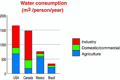
Consumption of water, by sector

Consumption of water, by sector © Tony Burton / Geo-Mexico, 2010; all rights reserved

Availability of water per person is a function of population size and the total amount of water available. Though Mexico gets more rain than the USA or Canada, the availability of water per person in Mexico is only one-twelfth that of Canada and about half that of the USA because Mexico’s population density is far higher. In other words, though each square kilometer in Mexico receives more rain on average, that rain must be divided among more people. Of 177 countries analyzed by the FAO, Mexico ranked 90th in terms of water availability per person. However, if Mexico is divided into two zones, the south would rank 51st and the north would rank 131st.

Within Mexico, the Lerma Basin (between Mexico City and Guadalajara) has only about 1/3rd the national average for water availability, while the very heavily populated Valley of Mexico (containing the Mexico City Metropolitan Area) has only 1/30th the national average.

Mexico’s per person consumption of water is about half that of Canada but with proportionately more allocated to agriculture. Nationally, about 75% of water consumption is used in agriculture, while settlements and industry use about 17% and 8% respectively.

Mexico’s water resources and water-related issues are the subject of chapters 6 and 7 of Geo-Mexico: the geography and dynamics of modern Mexico. Ask your library to buy a copy of this handy reference guide to all aspects of Mexico’s geography today! Better yet, order your own copy…

Attempts to provide drainage for Mexico City date back to Aztec times

 Excerpts from Geo-Mexico, Mexico's geography in the Press  Comments Off on Attempts to provide drainage for Mexico City date back to Aztec times
Apr 262011
 

An old joke relates how engineers initially rejoiced at successfully draining the former lake on which Mexico City was built (something the Aztecs had tried, but failed to achieve), only to discover that the city now lacked any reliable source of fresh water for its inhabitants (something the Aztecs had successfully managed by building a system of aqueducts).

Water has been a major issue for Mexico City since it was founded almost 700 years ago. Civil engineering works by the Aztecs included causeways and aqueducts connecting their island capital to the mainland as well as lengthy dikes separating the fresh water lakes from the brackish Lake Texcoco which surrounded the city.

The Spaniards did not maintain the Aztec civil works, deforested the surrounding hillsides, and started filling Lake Texcoco. This contributed to major flooding in 1555, 1580, 1604. The city was actually underwater (continuously!) from 1629–1634. During this period the Spaniards invested in several flood control efforts, but they were not successful. In 1788 they started construction of a massive canal to connect the basin to rivers north of the city flowing to the Gulf of Mexico. The open canal, which was up to 30 m (100 ft) deep in places, provided flood relief, but did not completely solve the problem, and flooding continued.

In the mid-1850s the government approved another massive flood relief scheme. Construction of the Gran Canal was delayed by numerous political and financial problems; it was not completed until 1900. The 58 km (36 mi) long canal included a 10 km tunnel, and carried lake water, storm water and sewage north to the Río Salado and eventually to the Gulf of Mexico. The scheme successfully drained most of the basin lakes, but summer flooding continued to be a problem for decades.

Mexico’s deep drainage system (drenaje profundo) was completed in the 1970s. It relies on a 68-km-long central tunnel (Emisor Central) which has a maximum depth of 250 meters below the surface. Built to allow for a flow of 170 cubic meters/second, subsurface subsidence under Mexico City had reduced its maximum capacity to barely 15 cubic meters/second by 2008.

Paradoxically for a city originally built on a lake and which experiences regular summer floods, Mexico City is desperately short of drinking water. The drilling of wells to obtain potable water from the aquifer under Mexico City is one of the main reasons for the ground subsidence which has reduced the effectiveness of the deep drainage system.

Many parts of Mexico City still experience serious drainage problems every rainy season. During the long dry season, many street drains plug with garbage (especially impermeable plastic bags). City motorists dread the first heavy rains of the year since much of the rainwater which falls is unable to find its way underground and backs up from blocked drains. City authorities have an annual campaign to try to clear all drains before the first rains, but are never completely successful.

Since 2007, jointly agreed programs to maintain and renovate the deep drainage system have been undertaken each year during the dry season by Mexico City and the administrations of adjoining states, in an effort to reduce the metropolitan area’s serious flood hazard. In the first four years (2007-2010), more than 42 km of tunnels have been renovated. The 2010-11 season of repairs to the drenaje profundo will be completed before the start of the rainy season (usually in late May or early June), according to city mayor Marcelo Ebrard.

Why are some parts of Mexico City sinking into the old lakebed?

Updates on the geography of Mexico City (26 March 2011)

 Mexico's geography in the Press  Comments Off on Updates on the geography of Mexico City (26 March 2011)
Mar 262011
 

This is the second in our series of periodic round-ups of news items related to the geography of Mexico City. The link to our first update in the series is Updates on the geography of Mexico City (13 December 2010)

Water meters in Mexico City

Ooska News reports that the SACM (Sistema de Aguas de la Ciudad de México, Mexico City Water System) plans to replace, repair or install 600,000 water meters for Mexico City before the start of the rainy season. About 300,000 of the 600,000 meters will be repairs or replacements; the other half are new installations. The cost of new meters will be added to the property’s water bill. The city government is considering how to help low-income residents meet the necessary payments. Residents living in parts of the city which as yet have no meters pay a fixed annual charge for water irrespective of the amount they consume. Having meters installed, so flows and consumption can be monitored, is absolutely essential as the SACM tries to tackle the problem of leaks in the water pipes supplying homes in the city. Some analysts estimate that as much as 25% of the water entering the system is lost through leaky pipes before it reaches its intended end-user.

Plastics recycling in Mexico City

Plastics recycling is one component of Mexico City’s waste separation program, which was established in response to the Solid Waste Law passed in 2003. Members of Mexico’s National Association of the Plastics Industry (a nationwide grouping of plastics makers) are investing $150 million in a pilot project to boost plastics recycling in Mexico City. The project seeks to increase the volume of plastic waste collected and reused by at least 10%.

Currently in Mexico City, only 12% of the 13,000 tons of waste generated each day is plastic, even though, by volume, plastics account for between 30 and 40% of all the waste generated.

Assuming the pilot project proves to be a success, the plastics collection and reuse program could be extended to the remainder of the country, leading to the possibility of doubling current recycling rates to around 35% of the 6 million tons of all kinds of plastics used each year.

Feb 222011
 

The Baja California peninsula is one of the most arid areas in Mexico and water shortages are becoming critical, especially along the southern coastline which has matured into one of the most desirable jet-set locations in the world.

Desalination, which involves removing the salts from seawater or brackish water to provide drinking water, is one viable option to ensure future water security for the region. There are already about 70 desalination plants on the Peninsula, though most are very small (25 liters/second or less) and are powered by conventional electricity. Several larger desalination projects on the Baja California Peninsula, some of which will rely mainly on solar power, are currently in the planning stages.

Map of Baja California PeninsulaLa Paz, the capital of the state of Baja California Sur, faces a particularly serious water supply problem. The local aquifer is reported to be already overexploited and suffering from salt water intrusions. Because of its greater density, seawater normally underlies freshwater in coastal areas. Salt water intrusions occur when so much fresh water is pumped out of coastal aquifers that it is replaced by the underlying salt water. The water supply issues have led to water rationing, in which almost half of La Paz’s 250,000 residents receive water only 12 hours or less each day.

Obtaining water from the desalinization of sea water is more expensive than abstracting water from aquifers via wells, but avoids the possibility of salt water intrusions.

A recent Ooska news article provides details of the desalination plants already built or being planned:

Baja California Sur:

Cabo San Lucas, opened in 2007, treats approximately 230 liters a second (60 gallons/s), equivalent to 20 million liters (5 million gallons) a day.

La Paz. Still at the proposal stage is a desalination plant capable of treating 200 liters a second.

Sierra de la Laguna. A Canadian mining company (Vista Gold Corp.) planned a desalination plant to provide water for its proposed Concordia open-pit mine. However, the mining plan was refused an essential permit by the Mexican government.

Baja California:

Ensenada. The 28-million-dollar El Salitral desalination plant is a “highly innovative project that would put the region on the map globally for desalination”. Construction is due to start later this year, and the plant should be operational by the end of 2012, when it will treat 250 liters of seawater a second. The plant would supply 96,000 people with potable water.

Rosarito. Preliminary geological and environmental impact studies are underway for a desalination facility in La Misión large enough to supply the needs of 96,000 people. Still in the concept stage is a second desalination plant  which would supply water across the border to San Diego in California.

San Quintín. Plans exist for a desalination plant with a capacity of 150 liters a second.

Main source: The OOSKA News Weekly Water Report for Latin America and the Caribbean (16 February 2011)

Want to read more?

USA agrees to “bank” some of Mexico’s entitlement of Colorado River water

 Mexico's geography in the Press  Comments Off on USA agrees to “bank” some of Mexico’s entitlement of Colorado River water
Jan 222011
 

In an earlier post, we described a 1944 treaty that guaranteed Mexico would receive at least 1750 million cubic meters of water  each year along the Colorado River (via the Morelos diversionary dam in the Mexicali Valley). However, in April 2010, the Mexicali area was rattled by a large earthquake, so powerful that it moved the southern part of California,  and severely damaged the irrigation infrastructure used by Mexican farmers on land in the lower Colorado River valley and the Colorado River delta. In all, 640 kilometers of irrigation canals were damaged, affecting 60,000 hectares of farmland.

The damaged infrastructure meant that Mexico was unable to use effectively its total annual allocation of water. Even as urgent repairs were begun on pumps, pipelines and irrigation channels in the Mexicali region, Mexican authorities opened talks with the USA to discuss the possibility of deferring receipt of  some of their annual water quota.

The two governments have now agreed “Minute 318” which permits Mexico to decrease its consumption from 2010 to 2013 and then receive the “saved” water later when the irrigation channels are all operational again.

Another major related development concerning the Colorado River is also now getting underway. The two governments are starting talks this year towards a comprehensive new long-term bilateral agreement covering the management of the Colorado River.

Mexico’s water resources and water-related issues are the subject of chapters 6 and 7 of Geo-Mexico: the geography and dynamics of modern Mexico. Ask your library to buy a copy of this handy reference guide to all aspects of Mexico’s geography today! Better yet, order your own copy…

More ground cracks appearing in Mexico City and the Valley of Mexico

 Mexico's geography in the Press  Comments Off on More ground cracks appearing in Mexico City and the Valley of Mexico
Jan 192011
 

The continued sinking of some parts of Mexico City in response to the over-extraction of water from underground aquifers, and consequent shrinking of the subsoil, has resulted in dozens of cracks in recent years. As noted in a previous post – Why are some parts of Mexico City sinking into the old lakebed? – some buildings in Mexico City have dropped more than seven meters (23 ft) since 1891.

According to Gabriel Auvinet Guichard, a researcher at the Engineering Institute of the National University (UNAM), cracks are becoming increasingly frequent. The largest cracks are up to 22 meters (72 feet) deep and 30 meters long. The cracks damage buildings and infrastructure (especially roads and water pipes), and have alarmed residents in some areas in the city.

Auvinet’s team at UNAM’s Geoinformatics Laboratory is compiling a database of all known cracks. They plan to produce maps showing the incidence, location and origin of the cracks to help construction companies meet building regulations. The database has records of 380 fissures at present, but is still far from complete.

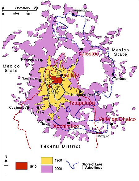
Some areas in the Valley of Mexico are much more prone to the earth movements leading to cracks than others. The areas with a high incidence of cracks include Iztapalapa, Chalco, Xochimilco, Xalostoc and Vallejo (see map).

Mexico City cracks map

Locations in Valley of Mexico with high incidence of ground cracks. Cartography: Tony Burton; all rights reserved.

Chapter 23 of Geo-Mexico: the geography and dynamics of modern Mexico looks at urban issues, problems and trends. To preview more parts of the book, click here and use amazon.com’s “Look Inside” feature.

Two major aqueducts in the Lerma-Chapala basin

 Mexico's geography in the Press  Comments Off on Two major aqueducts in the Lerma-Chapala basin
Jan 152011
 

Two major new aqueducts will help to ensure reliable water supplies for Guadalajara and León, two rapidly growing cities in the Lerma-Chapala basin.

SIAPA (Sistema Intermunicipal de Agua Potable y Alcantarillado) is the acronym for the water supply system for the city of Guadalajara, Mexico’s second largest metropolitan area (population: 4.4 million). About 60% of Guadalajara’s potable water comes from Lake Chapala, the country’s largest natural lake, via an aqueduct. According to SIAPA Director José Luis Hernández Amaya, this existing aqueduct, built more than 20 years ago, is now inadequate. SIAPA now has construction permits in place to build a second aqueduct supplying water to the city from the lake. The plans for the second aqueduct have been approved by both state and federal regulatory bodies (the Comisión Estatal del Agua and the Comisión Nacional del Agua (Conagua) respectively).

All parties agree that boosting the amount of available water is essential for a city growing as rapidly as Guadalajara. The new aqueduct, likely to cost 2,000 million pesos, will enable the city to undertake maintenance as needed on the pumping stations and channels of both systems. Undertaking maintenance on the existing system without opening a parallel channel would involve cutting off the water supply for up to 60% of Guadalajara’s population for several days.

A new aqueduct is also planned for the city of León. According to recent press reports, the El Zapotillo dam on the Río Verde is about 21% complete. The resulting reservoir will guarantee adequate water supply for León (population: 1.6 million), and reduce its dependence on groundwater abstraction. Tenders are now being accepted for the construction of a 139-km-long aqueduct from El Zapotillo to join León’s potable water system, together with two pumping stations and a water purification plant.

The new reservoir and aqueduct should ensure that León’s water demands are met for between 25 and 30 years. In addition to León, several other municipalities will also benefit from an improved water supply, including Jalostotitlán, San Miguel el Alto, Encarnación de Díaz, San Juan de los Lagos and Lagos de Moreno.

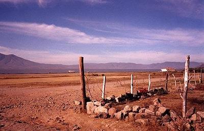
Lake Chapala in 2002

Lake Chapala in 2002, more like a desert than a lake. The lake has since recovered.

Neither plan is without its critics. Activists at Lake Chapala are concerned that supplying more water from the lake to Guadalajara will return the lake to the precarious state it was in during the 1990s. Opponents to El Zapatillo claim that the main demand for water in León is from the new industrial estates and leather tanning plants, and that supplying them with more water will only lead to further serious contamination and even more wastage of the valuable resource.

Rivers, reservoirs and water-related issues are discussed in chapters 6 and 7 of Geo-Mexico: the geography and dynamics of modern Mexico. Ask your library to buy a copy of this handy reference guide to all aspects of Mexico’s geography today! Better yet, order your own copy…

New aqueduct should guarantee water supply for the city of Hermosillo

 Mexico's geography in the Press  Comments Off on New aqueduct should guarantee water supply for the city of Hermosillo
Jan 082011
 

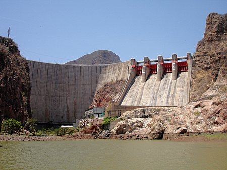
According to press reports, construction is underway of the “Independence Aqueduct” which will carry water from the Plutarco Elías Calles reservoir on the Yaqui River, in southern Sonora, to Hermosillo, the state’s capital city. The reservoir is the 11th largest in Mexico with a capacity of 2,925 million cubic meters.

Javier Gándara Magaña, the mayor of Hermosillo (population 780,000), expects the 150-km-long aqueduct to be functioning by 2012 though he has warned residents that water brought from the reservoir (commonly known as El Novillo) will be more expensive than that from existing sources. City authorities plan to have installed water meters in every dwelling prior to the completion of the aqueduct.

novillo dam sonora

Curtain of El Novillo dam, Sonora

The aqueduct will supply 75 million cubic meters a year to the city, and represents a long-awaited, and long-term, solution to the water problems faced by Hermosillo, which is located in one of the driest regions of the country. At a later stage, the reservoir will also supply 500 million cubic meters a year to the municipality of Cajeme, in the northwest of the state.

Construction of the aqueduct is opposed by many members of the indigenous Yaqui communities and by agricultural producers farming the Yaqui Valley in the south of Sonora who claim that diverting water to Hermosillo will jeopardize the long-term water security for their operations.

Rivers, reservoirs and water-related issues are discussed in chapters 6 and 7 of Geo-Mexico: the geography and dynamics of modern Mexico. Ask your library to buy a copy of this handy reference guide to all aspects of Mexico’s geography today! Better yet, order your own copy…

Where in Mexico do people still lack access to potable water?

 Maps, Teaching ideas  Comments Off on Where in Mexico do people still lack access to potable water?
Nov 162010
 

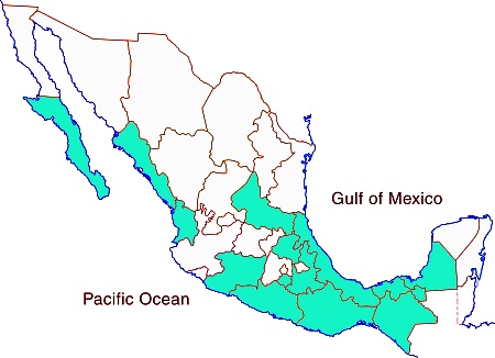
The map shows the 14 states in Mexico where less than 90% of the population has potable water in their homes.

map of potable water in Mexico

The 14 states with poorest potable water access in Mexico

How does the distribution of state with relatively poor access to potable water compare with maps of:

Development indices of various kinds are discussed in chapters 29 and 30 of Geo-Mexico: the geography and dynamics of modern Mexico. Ask your local library to purchase a copy today!

Why are some parts of Mexico City sinking into the old lakebed?

 Excerpts from Geo-Mexico  Comments Off on Why are some parts of Mexico City sinking into the old lakebed?
Nov 042010
 

Mexico City was built originally (ca. 1325) on an island in the middle of a lake, and eventually became the capital of the powerful Aztec Empire.

The provision of potable water is a problem that has plagued the city for centuries. Deforestation in the 19th century depleted the springs that had supplied the city with fresh water via aqueducts (some dating from precolonial times). The first fresh water well was built in the city center in 1857. By 1900 there were hundreds of wells sucking water from the underground aquifer.

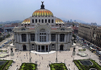
As more and more water was sucked up through the wells, the city began to sink. Some parts have dropped more than seven meters (23 ft) since 1891. Parts of the city center sank more than a meter between 1948 and 1951, and another meter by 1960. The city sank two meters below what remained of Lake Texcoco, posing a serious risk of flooding during the rainy season. In response, engineers sank wells into Lake Texcoco, sucked water from the aquifer, and the lake level dropped below the height of the city center.

Bellas Artes opera house, Mexico City

Rates of subsidence are very uneven. In places the weight of large buildings has caused them to sink into the dried out mud. The city’s magnificent Opera House (Palacio de Bellas Artes, see photo) sank so far that its original ground floor is now a subterranean basement. To slow down the rate of sinking in the city center, in 1950 new wells were drilled south of the city reducing central city sinking to its current rate of about 10 cm (4 in) a year. Of course, areas in the south started sinking more rapidly.

Elsewhere, buildings (including the Cathedral) have tilted and underground sewers and water pipes have cracked and broken. Furthermore, drains in the city center sank below the large drainage canals and pumps had to be added to lift storm water and sewage up to the drainage canals.

These ground movements pose major challenges for the construction and maintenance of the city’s extensive metro network.

This is a lightly edited excerpt from chapter 23 of Geo-Mexico: the geography and dynamics of modern Mexico. If you have enjoyed this post, please consider purchasing a copy of Geo-Mexico so that you have your own handy reference guide to all aspects of Mexico’s geography.

Dust, snowmelt and the reduced flow of the Colorado River into Mexico

 Other  Comments Off on Dust, snowmelt and the reduced flow of the Colorado River into Mexico
Oct 262010
 

The Colorado River flows almost entirely in the USA, though its extensive delta is in Baja California. The USA and Mexico have negotiated usage rights designed to guarantee a minimum flow reaching Mexico and to safeguard the water available for numerous cities in the USA that depend on water from the Colorado, and for the rapidly-growing urban centers of Mexicali, Tijuana, Tecate and Rosarito in Baja California.

Even so, the amount of water reaching Mexico has declined dramatically as a result of the Hoover and Glen Canyon dams and other diversions of Colorado River water in the USA. The Colorado River delta has been almost totally dry for most of the last decade.

A new study led by a NASA scientist, links increased human activity in the USA over the past 150 years to earlier annual snowmelt in the Rocky Mountains and reduced flow rates in the Colorado River.

According to the study:

  • lake sediments reveal that between 5 and 6 times as much dust now falls on the Rocky Mountains as 150 years ago – an increase attributed to soil disturbances caused by agriculture and grazing
  • dust settling on snow makes the surface darker, enabling it to absorb more incoming solar energy (ie. the dust changes the albedo of the surface)
  • this increased absorption of solar energy causes earlier snowmelt and more evaporation to enter the atmosphere – peak spring runoff now comes three weeks earlier than 150 years ago
  • this earlier snowmelt exposes vegetation, causing plants to lose more water to the atmosphere than previously – this loss is estimated at almost 1 billion cubic meters (35 billion cubic feet) of water each year
  • this loss of water causes river discharges to be lower than previously; the annual runoff averages less than 95% of the levels found prior to extensive human settlement
  • earlier snowmelt leads to earlier peak runoff into rivers. This complicates water management, especially during the summer.

How much is 1 billion cubic meters of water?

  • sufficient to meet the demands of the entire city of Los Angeles for 18 months
  • more than 50% of the amount of water guaranteed to enter Mexico each year via the Colorado by a 1944 USA-Mexico treaty
  • about 14% of the current volume of Lake Chapala, Mexico’s largest natural lake

How can the situation be reversed/ameliorated?

One successful strategy, mentioned in the article, has been the Taylor Grazing Act (1934). This has improved conditions on public grazing lands, decreasing the amount of dustfall in the Rockies by about 25%. Other strategies are needed since climate change may well exacerbate the effects the additional dust has had on river flows.

Related posts:

Rivers, reservoirs and water-related issues are discussed in chapters 6 and 7 of Geo-Mexico: the geography and dynamics of modern Mexico. Ask your library to buy a copy of this handy reference guide to all aspects of Mexico’s geography today! Better yet, order your own copy…

New irrigation areas in Chihuahua, Mexico, are visible from space

 Books and resources  Comments Off on New irrigation areas in Chihuahua, Mexico, are visible from space
Oct 212010
 

A recent article on Wired.com drew my attention to these spectacular Landsat photos of Chihuahua, Mexico.

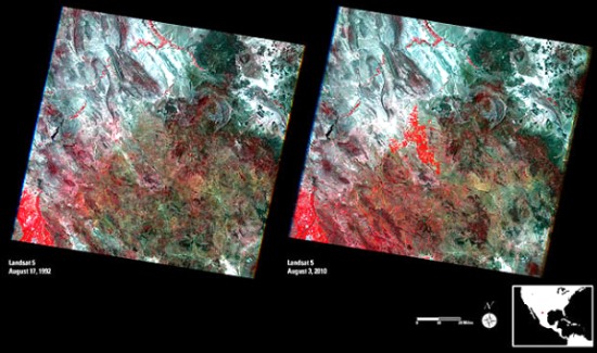
Landsat images of Chihuahua

  • Link to high resolution Landsat images (clicking on the images in this link reveals amazing detail)

These false-color remote sensing images were taken by the Landsat 5 satellite in August 1992 (left) and August 2010 (right).

  • Red = vegetation (the brighter the red, the healthier the vegetation)
  • Whites, greens, browns = areas with bare soil or only limited vegetation (colors depend on organic matter and moisture content)
  • Blue & Black = water (clear, deep water is darker; sediment-laden water is lighter)
  • Blue-Gray = urban areas

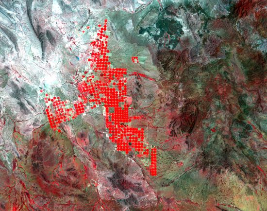
They show some interesting changes have taken place in the 18 years since the first image was captured. In particular, they reveal that more water is now available from a major reservoir, and is being used for irrigation. Particularly noticeable is the development of round irrigation areas in the central part of the images. These circular areas, which show as bright, red circles (see image below) are the result of center-pivot irrigation systems. The water is being used for growing alfalfa and sorghum to feed livestock.

Circular irrigation areas

Circular irrigation areas (enlarged view of center portion of 2010 image)

In addition to the impacts resulting from irrigation, diverting more water from the reservoir has also affected the area’s native vegetation, and reduced the amount of water flowing into the Río Grande River. This may have ameliorated, at least slightly, the serious flooding which occurred earlier this year in the same general area.

April earthquake leads to Mexico-USA talks over water-sharing

 Mexico's geography in the Press  Comments Off on April earthquake leads to Mexico-USA talks over water-sharing
Sep 142010
 

In April 2010, a large earthquake rattled the Mexicali area, causing significant damage. It was so powerful that it even moved the southern part of California! The magnitude 7.2 earthquake damaged the irrigation infrastructure used by Mexican farmers on land along the lower Colorado River and in the Colorado River delta region.

Mexico and US officials are reported to be discussing the Colorado water-sharing agreement, given the damage done to irrigation facilities following the April earthquake (The OOSKA News Weekly Water Report for Latin America and the Caribbean, 18 August 2010).

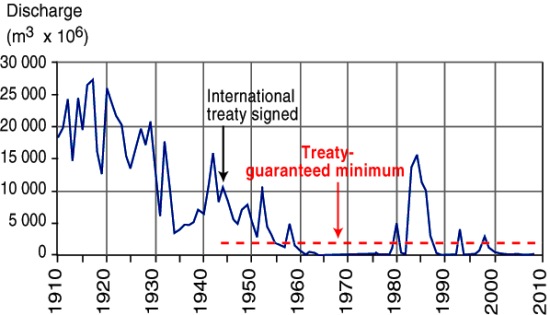
River Colorado discharge entering Mexico, 1910-2010

River Colorado discharge entering Mexico, 1910-2010. Figure 6.5 of Geo-Mexico; all rights reserved

As we noted in an earlier post, a 1944 treaty guaranteed that at least 1750 million cubic meters of water (see graph) would enter Mexico each year along the Colorado River via the Morelos diversionary dam in the Mexicali Valley. The damaged infrastructure means that Mexico is unable to use effectively all of its annual allocation of water from the Colorado. Urgent repairs are underway on pumps, pipelines and irrigation channels, particularly those in the Mexicali region.

Meanwhile, Mexican officials have asked their US counterparts if it is possible to store some of Mexico’s 2010 allocation of water in the Lake Mead reservoir near Las Vegas, until repairs to irrigation systems have been completed.

Earthquakes in Mexico are discussed in detail in chapter 2 of Geo-Mexico: the geography and dynamics of modern Mexico. Mexico’s water resources and water-related issues are the subject of chapters 6 and 7. Ask your library to buy a copy of this handy reference guide to all aspects of Mexico’s geography today! Better yet, order your own copy…

Fascinating new book about the Colorado River

 Books and resources, Excerpts from Geo-Mexico, Maps  Comments Off on Fascinating new book about the Colorado River
Aug 162010
 

The Río Colorado formed a vast delta in the otherwise arid Sonoran desert in northern Mexico where it enters the Sea of Cortés (Gulf of California, see map.) The delta wetlands created ideal conditions for a rich variety of wildlife. The river enters Mexico at the Southerly International Boundary where a gauging station records the river’s discharge. This river is one of the most altered river systems in the world.

Map of the Colorado delta

Map of the River Colorado delta. All rights reserved.

The amount of water reaching Mexico has declined dramatically as a result of the Hoover and Glen Canyon dams and other diversions of Colorado River water in the USA. The few years of higher flows in the 1980s coincide with flood releases from US dams when they had been filled by heavy rains.

The river’s drastically reduced annual discharge violates a 1944 treaty under which the USA guaranteed that at least 1750 million cubic meters would enter Mexico each year via the Morelos diversionary dam in the Mexicali Valley. The Río Colorado wetlands have been reduced to about 5% of their original extent, and the potential water supply for the rapidly-growing urban centers of Mexicali, Tijuana, Tecate and Rosarito has been compromised.

The map and description above come from Geo-Mexico: the geography and dynamics of modern Mexico.

If you are interested in learning more about this river, a great place to start is the recently published book about the Colorado River called Running Dry: A Journey From Source to Sea Down the Colorado River (Jonathan Waterman; National Geographic Books, 2010). Waterman hiked and paddled the length of the river from the Rocky Mountain National Park to its delta in the state of Baja California, Mexico.

For excerpts from the book, see Running Dry on the Colorado and Mighty Colorado River dribbles through Mexico.

Peter McBride, a photographer, accompanied Waterman on his two year trek. His evocative photographs will appear in the book The Colorado River: Flowing Through Conflict (Westcliffe Publishers), due out in September. See Down the Colorado (slideshow) for some examples of his Colorado River photos.

Rivers, reservoirs and water-related issues are discussed in chapters 6 and 7 of Geo-Mexico: the geography and dynamics of modern Mexico. Ask your library to buy a copy of this handy reference guide to all aspects of Mexico’s geography today! Better yet, order your own copy…

Geo-Mexico is reader-supported. Purchases made via links on our site may, at no cost to you, earn us an affiliate commission. Learn more.

An update on flood protection in the state of Tabasco, Mexico

 Excerpts from Geo-Mexico, Updates to Geo-Mexico  Comments Off on An update on flood protection in the state of Tabasco, Mexico
Aug 032010
 

The small, oil-rich state of Tabasco, one of Mexico’s wettest states, is regularly subjected to serious flooding. Much of the state is a wide coastal plain of sediments brought by rivers from the mountains of Chiapas and Guatemala. Two major rivers—the Grijalva and the Usumacinta—converge in the Pantanos de Centla wetlands. These rivers have meandering, braided channels and highly variable flows, partly because of hydropower dams far upstream.

The state’s high incidence of floods has been exacerbated by subsidence and deforestation due to oil and gas extraction which has led to excessive silting of river channels. Looking to the future, rising sea levels will only increase this area’s vulnerability to flooding.

The flood of 2007

Several days of heavy rainfall due to a low pressure system led in late October and early November 2007 to massive floods,  called at the time by President Felipe Calderón “one of the worst natural disasters in the history of the country.” About 80% of Tabasco was under water at one point.

Tabasco produces 80% of Mexico’s total cacao and 40% of its bananas; the losses of farm harvests alone were estimated at $480 million. The floods disrupted the lives of more than a million residents, and 20,000 people were forced to seek emergency shelter. The state capital Villahermosa, located near the junction of three branches of the Grijalva River, was particularly badly hit.

It has been claimed that the 2007 floods would have been much less serious if funds allocated for hydrologic infrastructure improvements had not been misappropriated.

2008 Hydrological Plan

A new Tabasco Hydrological Plan was announced in 2008. The $850 million plan should ensure the integrated management of six river basins and major improvements to the systems for storm tracking, weather forecasting and disaster prediction. Several rivers will be dredged and the coast will be reinforced with breakwaters and sea walls.

2009 Flood

Unfortunately, the plan could not be implemented in time to prevent serious damages from the next big Tabasco flood in early November 2009 which inundated the homes of more than 200,000 people.

2010 update on Hydrological Plan

Now, we learn from The OOSKA News Weekly Water Report for Latin America and the Caribbean (28 July 2010)  that state politicians are considering a lawsuit against the National Water Authority for failure to competently oversee all the various contracts involved in the 2008 Hydrological Plan. A local newspaper in Tabasco state reports that 10 companies failed to deliver the dredging and flood protection works they had been contracted to do, and so far, the National Water Commission has failed to collect fines of about 770,000 dollars for non-compliance, as stipulated in their contracts. The original contracts were valued at 6.7 million dollars, and were apparently paid in advance. All work was scheduled to have been completed by March of 2009.

Federal politicians are now claiming that the National Water Authority’s failures led directly to further serious flood damage in late 2009, which would have been avoided if the work had been completed on time.

According to a Mexico City daily, Tabasco’s 2008 Hydrological Plan is still only approximately 50% complete, as of July 2010.

Rivers, floods and water-related issues are discussed in chapters 6 and 7 of Geo-Mexico: the geography and dynamics of modern Mexico. Ask your library to buy a copy of this handy reference guide to all aspects of Mexico’s geography today! Better yet, order your own copy…

Mexico’s major dams and reservoirs

 Excerpts from Geo-Mexico  Comments Off on Mexico’s major dams and reservoirs
Jul 192010
 

The functions of dams and reservoirs

Mexico’s dams and reservoirs serve many valuable functions. The first is as a source of hydroelectric power. The amount of power that can be generated is a function of the amount of water streaming through the generators and its pressure, which is related to the height of the dam. Just over half of hydroelectric power is generated by dams on rivers which start in southern mountain ranges and flow into the southern portion of the Gulf of Mexico. Most of the rest comes from dams on rivers along the Pacific coast from the Balsas basin all the way north to Sonora.

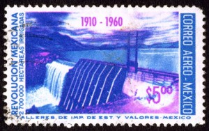
Postage stamp depicting dam and reservoir

The 50th anniversary of the Mexican Revolution: dam, reservoir and water power.

Hydroelectric power has been important since the early part of the twentieth century. Currently about 22% of the electricity  generating capacity is from hydroelectric plants. The largest hydroelectric plants are on the Grijalva River in Chiapas. Other rivers providing significant hydropower are the Balsas, Santiago, Fuerte, Papaloapan and Moctezuma.

Virtually all Mexican dams, except those in the rainiest southern areas, provide water for irrigated agriculture. This is particularly true in arid northern Mexico. Mexico ranks sixth in the world with about 63,000 cubic kilometers of irrigated agriculture. It is well behind India (558,000), China (546,000), the USA (224,000), Pakistan (182,000) and Iran (76,500). About 23% of Mexico’s cultivated area is irrigated, compared to 99.9% in Egypt, 82% in Pakistan, 47% in China and only 12% in the USA.

Dams also protect against floods, especially in the drier northern areas which are very susceptible to floods from rare but torrential downpours.

In addition, dams provide a source of water for urban populations, especially in the largest metropolitan areas.

Finally, the reservoirs behind dams throughout Mexico are an important recreational resource.

On the other hand, the construction of dams can also have negative effects, including habitat loss, the need to relocate existing residents away from the reservoir site, adverse changes in river flows downstream of the dam and sediment accumulation behind the dam which reduces the reservoir’s capacity.

Chapter 6 of Geo-Mexico: the geography and dynamics of modern Mexico is about water availability, rivers and aquifers; it includes several maps including one showing the relative sizes of the main reservoirs.

Mass evacuations and flood alerts follow Hurricane Alex

 Mexico's geography in the Press, Updates to Geo-Mexico  Comments Off on Mass evacuations and flood alerts follow Hurricane Alex
Jul 072010
 

The final death toll from Hurricane Alex last week stands at 12. It is a tribute to the effective preparations made by residents and authorities in advance of the storm, and to relief efforts, that more people did not lose their lives.

The center of Monterrey, an industrial center which is Mexico’s third largest city, was briefly turned into a raging torrent, with widespread damage to roads and infrastructure. Click here for a photo gallery showing some of the extensive damage caused by Huricane Alex.

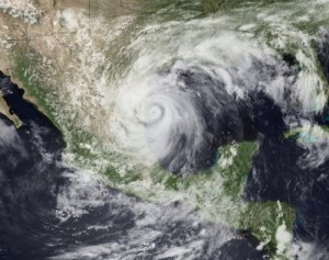
Hurricane Alex

Hurricane Alex. Photo: NOAA. Click to enlarge.

In addition to those made homeless as a direct result of the storm, a further 18,000 people have been evacuated from their homes because they are downstream of the Venustiano Carranza dam, located about 70 km (43 miles) away, which is now at bursting point.

The authorities in Ciudad Anahuac (a short distance south-west of Nuevo Laredo) have opened some of the dam’s floodgates to ease the water pressure but the situation is still reported to be critical. The opening of the floodgates released 600 cubic meters of water a second into the Río Salado, a tributary of the Río Bravo/Grande. Meanwhile, residents have been moved to shelters in nearby towns.

Santos Garza Garcia, the town’s mayor, told reporters that “It was preferable to have controlled flooding than having the whole town disappear.”

In a related development, the bi-national International Boundary and Water Commission, which adjudicates Mexico-USA border issues, ordered the release of 1,000 cubic meters a second (35,000 cubic feet per second) of floodwater from the Amistad reservoir into the Río Grande. The Amistad reservoir straddles the border upstream of the cities of Del Río (Texas) and Ciudad Acuña (Coahuila).

The heavy rains had already swollen the Río Bravo/Río Grande (which forms along the Mexico-USA border) to dangerous levels. The level of the river is being continuously monitored. Its level has risen by as much as 6 meters (20 feet) above normal. As a precaution, several border crossings, including the international bridge between Laredo (Texas) and Nuevo Laredo (Tamaulipas) have been closed.

It is the first time since 1995, that an Atlantic hurricane has struck Mexico’s Gulf coast as early as June. Everyone hopes that the main hurricane season, in July-August-September, does not bring further loss of life and property damage.

Additional note added Thursday July 8: The Mexico-USA border area may be in for a very wet week, since Tropical Storm 2 (which would become Hurricane Betty if wind speeds increase) is now approaching. Weather Underground has more details and maps showing the possible storm paths.

Earlier posts:

Mexico’s climatic hazards, including hurricanes, are analyzed in chapter 4 of Geo-Mexico: the geography and dynamics of modern Mexico. Buy your copy today, so you have a handy guide to the “back story” behind Mexico’s current affairs.