Transit of Venus will be visible from Mexico, 5 June 2012

 Other  Comments Off on Transit of Venus will be visible from Mexico, 5 June 2012
May 312012
 

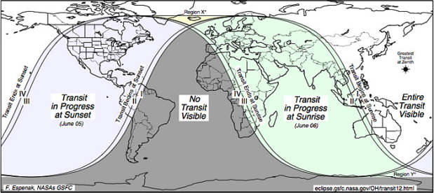
Next week, clear skies permitting, a Transit of Venus will be visible from all of Mexico (as well as the USA, most of Canada, etc). During a transit of Venus, the planet Venus passes slowly in front of the sun from the perspective of a viewer on Earth.

CAUTION: Never observe the sun directly, even during a transit of Venus, or your eyesight may be permanently damaged. Transit viewers should take similar precautions to those needed to observe an eclipse.

Such events are rare. This will likely be the last chance to see one in your lifetime since the next transit of Venus will be in more than 100 years time!

Map showing areas where transit of Venus is visible

Map showing areas where transit of Venus is visible [Credit: NASA

Back in the eighteenth century, scientists from France anxious to observe the 1769 transit of Venus were forced to seek permission from Spain to join a party of Spanish astronomers setting up a temporary observatory in a Spanish colony which was predicted to offer the best views. These astronomers congregated at a site very near the present-day settlement of San José del Cabo on the southern tip of the Baja California peninsula. A short distance away, a creole astronomer Joaquín Velázquez de León, who had traveled from Mexico City, set up camp to make his own independent observations. Scientific trips at this time were not without their perils; only days after the transit, three members of the Franco-Spanish party, including the two principal astronomers, died after contracting yellow fever.

The next transit of Venus occurred in the year 1874. Mexico has a particular connection to this transit. To observe this event, and take scientific measurements, Mexico’s first ever international scientific expedition was undertaken. A distinguished group of Mexican scientists traveled to Japan to study this event. By the time they returned, they had been all the way around the world.

Mexico has a long history of astronomy. Several indigenous groups, including the Zapotecs in Oaxaca and the Maya in the Yucatán Peninsula undertook sophisticated astronomical observations, enabling the successful prediction, not only of annual events such as the summer solstice, but also of longer-term phenomena such as eclipses. Mexico (admittedly not called that at the time!) hosted one of the earliest international astronomical conferences in the world.

According to some, the Maya predicted that the world will come to an end on 21 December next year. The claims are based on the fact that the current Maya calendar cycle “ends” on that day. The Maya have several simultaneous calendar counts. Each long cycle count, or B’ak’tun, lasts 394.3 years. The very first B’ak’tun began on 11 August 3114 BC, the date when the Maya believe they were created. The 13th B’ak’tun ends on 21 December 2012, hence the concern propagated by panic-mongers.

The Maya themselves don’t seem too worried by these alarmist claims. They worked out years ago that their 14th B’ak’tun cycle will start the next day, 22 December 2012, and run to sometime in 2406. On the other hand, is it just a simple coincidence that on 21 December 2012, at the exact moment of the winter solstice at 23:11 UST, the sun will be precisely aligned with the center of the Milky Way galaxy, as seen from Earth— the first time this has happened for 26,000 years?

Will the claims be proven true? Unlikely, but perhaps we won’t plan to write any posts about the geography of Mexico for publication after 22 December 2012 until we’re absolutely sure…

Need more evidence about the Maya prediction? As a starting-point, try:
May 282012
 

In his classic book, The Wealth of Nations, Adam Smith proposed that division of labor and economic specialization were the keys to increases in productivity and the wealth of nations. While Smith was primarily talking about the degree of specialization within nations, specialization among nations and comparative advantage were also important. Obviously, in the 21st century there is specialization within and among all nations, but some are more specialized or more complex than others. But how can economic complexity be measured?

Fortunately this question is addressed head-on by Ricardo Hausmann, Cesar Hidalgo and their co-researchers in The Atlas of Economic Complexity (Harvard HKS/CDI – MIT Media Lab, 2011). They argue that highly complex economies produce sophisticated products that require a very wide and diverse set of knowledge capabilities. Very few countries have the capabilities to produce such sophisticated products which might include the very specialized equipment and very precise measuring instruments needed to produce highly complex chemicals or pharmaceuticals. Other examples might include the range of knowledge capabilities needed to build a nuclear power plant or space station. Obviously very few nations with very complex economies have these capabilities.

At the other end, a very large number of countries with less complex economies have the range of capabilities needed to produce simple products like basic foods, mineral ores, lumber, garments, shoes, glass, kitchen utensils, candles and furniture.

In producing an atlas that covered a large number of countries, the authors were limited by the availability of data. They decided to use information on exports because the data were available and the range of exports reveal the complexity of an economy. Unfortunately, accurate data are only available on the trade of physical products; they are not available for services which are the dominant sector for modern economies. On the other hand, the sophistication of product exports does a good job of capturing the complexity of economies.

In developing their Economic Complexity Index or ECI, the authors developed a product complexity index based on the number of countries capable of making and exporting specific products as well as the diversity of products exported by specific countries. The Atlas presents ECIs for the 128 countries that had reliable data, populations over 1.2 million and trade over $1 billion.

RankCountryEconomic Complexity IndexIncome/person (2009 US$)
1Japan2.31639,738
2Germany1.98540,670
3Switzerland1.93563,629
4Sweden1.85943,654
5Austria1.80745,562
6Finland1.71544,581
7Singapore1.63936,537
8Czech Republic1.62818,139
9U.K.1.55835,165
10Slovenia1.52323,726
11France1.47341,051
12South Korea1.46917,078
13USA1.44745,989
14Hungary1.43012,868
15Slovak Republic1.37916,176
16Italy1.30835,084
17Denmark1.26755,992
18Ireland1.23151,049
19Israel1.16426,256
20MEXICO1.1458,143

The 20 countries with the highest Economic Complexity Indices are presented in the table, along with their 2009 per capita income. Japan is clearly the most complex economy followed by Germany, Switzerland, Sweden and Austria. The USA is ranked 13th and Canada is 41st. Fourteen of the top 20 countries are European; most are high income, highly industrialized countries. Countries with large natural resource exports tend to rank low in economic complexity. Norway is 33rd, Russia 46th, New Zealand 48th, Brazil 52nd, Saudi Arabia 68th, Australia 79th.

Mexico is ranked 20th which is very impressive since all others in the top 20 have significantly higher incomes. Mexico does very well compared to other large emerging economies: China is 29th; Turkey is 43rd, Russia is 46th, India is 51st, Brazil is 52nd, South Africa is 55th, Argentina is 57th and Indonesia is 61st. Mexico’s economic complexity has grown significantly in the past 50 years. It grew from 0.39 in 1964 to 1.14 in 2008; this increase ranked it 14th of 99 countries. (Countries improving faster than Mexico include: Thailand 2nd, Indonesia 5th, Brazil 7th, and Turkey 10th.) Over 60% of Mexico’s growth occurred between 1998 and 2008 when its ECI jumped from 0.80 to 1.14.

The Atlas argues that countries such as Mexico, with high levels of complexity given their income level, are expected to grow more rapidly in future years. We will explore this topic further in a future post.

Related posts:


How important is the fishing industry in Mexico?

 Excerpts from Geo-Mexico  Comments Off on How important is the fishing industry in Mexico?
May 262012
 

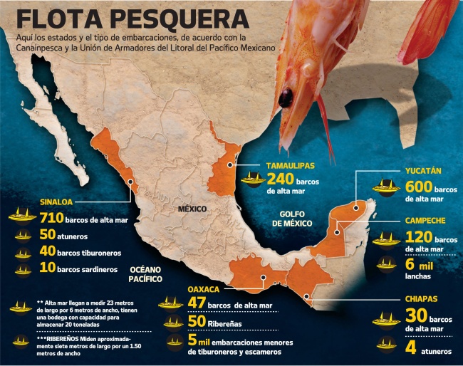
The fishing industry now accounts for only 0.24% of gross national product. The relatively shallow waters off the Pacific coast and abundance of plankton in waters cooled by the Californian current make for particularly good fishing in the north-west. Together, Sinaloa (23%) and Sonora (22%) account for about 45% of the national total. Fishing is also economically important in Veracruz (8%), Baja California Sur (6%), Campeche and Baja California (5% each) and Yucatán.

Mexico's fishing fleet

Mexico's fishing fleet

Almost three quarters (72%) of the total annual catch of 1.5 million metric tons is landed at Pacific coast ports such as Guaymas, Mazatlán and Manzanillo. Gulf coast ports like Tampico, Veracruz and Campeche, together with Caribbean coast ports such as Puerto Morelos and Progreso, account for a further 25% of the catch. The remaining 3% comes from inland lakes, rivers and fish farms.

In terms of value, the most important species are shrimp, tuna and sardines. Fresh-water fish farms are becoming more common, with many of them specializing in the production of high value species such as trout and indigenous white fish. Mexicans consume only 13 kg (29 lbs) of fish per person per year on average, considerably less than the equivalent figures for the USA (21 kg), Canada (24 kg) or Spain (44 kg).

Related posts:


How does Mexico’s electoral process compare to other countries?

 Other  Comments Off on How does Mexico’s electoral process compare to other countries?
May 232012
 

On 1 July 2012 Mexicans go to the polls to elect a new six year president, a new senate and chamber of deputies. At the same time, voters in some states–Jalisco, Nuevo León, Guanajuato, Querétaro, Sonora, San Luis Potosí, Morelos, Federal District, Campeche and Colima– will cast their ballots in elections for state and local officials.

How free and fair are Mexican elections compared to those in other countries?

Before addressing this question, it is useful to acknowledge that elections in Mexico have improved dramatically in the past two decades, largely as a result of progressive reforms including the establishment of a strong and independent National Elections Commission (Instituto Federal Electoral, IFE). Prior to the late 1990’s one party, PRI (Partido Revolucionario Insititucional, Institutional Revolutionary Party) dominated most elections at the national, state and local level. Starting in 2000, when an opposition party, PAN (PAN or Partido Acción Nacional, National Action Party), won the presidency, elections in Mexico have been quite competitive. In 2006 a third party, PRD (Partido de la Revolución Democrática, Party of the Democratic Revolution), lost the presidency to PAN by less than 0.6% (35.89% to 35.31%). Since 1994 the winner of the presidency has not garnered 50% of the votes, leading some to argue that Mexico should conduct runoffs between the two highest vote-getters.

CountryScoreCountryScoreCountryScore
Uruguay10.00Peru9.17Turkey7.92
Canada9.58MEXICO8.75Indonesia6.92
Chile9.58Argentina8.75Venezuela5.67
India9.58Israel8.75Nigeria5.67
Brazil9.58South Africa8.75Russia3.92
USA9.17Guatemala7.92China0.00
Colombia9.17

The Economist Intelligence Unit (EIU) annually develops a “democracy index” which includes a factor titled “electoral process and pluralism”. Scores on this factor are based on 12 questions concerning the conduct of free, fair and transparent elections open to all groups and all voters as well as the orderly transfer of power to those winning elections. Based on the EIU scores for 2011, countries with the perfect score of ten were Uruguay, Norway, Iceland, Denmark, Finland, Luxembourg, Australia and New Zealand. Mexico is tied with Argentina, Israel and South Africa, trails Chile, Brazil, Colombia and Peru but is much closer to the top than the bottom (see table). Mexico is a point and a quarter below a perfect ten and almost a point ahead of Guatemala, three ahead of Venezuela and almost five ahead of Russia. China is last with a score of zero along with Saudi Arabia, Ethiopia, North Korea, and other authoritarian regimes.

It will be interesting to see how the EIU scores Mexico after the 2012 elections.

 Related posts:


Mexico City in colonial times: 1530–1820

 Excerpts from Geo-Mexico  Comments Off on Mexico City in colonial times: 1530–1820
May 212012
 

The internal geography of cities is closely related to transportation technology. Pre-Columbian cities in Mexico were walking cities; the wheel had not been developed and animals were not used for transport. Human power moved people and goods, but not very quickly or efficiently. As a result, cities were relatively compact and congested; densities were high. Despite these transport restrictions, at least one urban center in pre-Columbian Mexico had a population estimated to exceed 200,000.

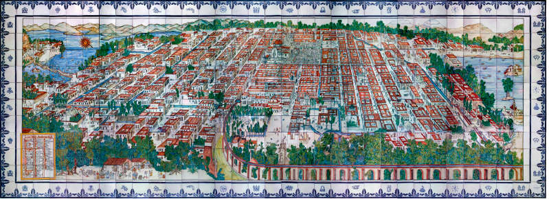
The Aztec capital Tenochtitlan was built on an island in the middle of a lake, and was a thriving city when Hernán Cortés arrived. After the conquest, the Spaniards built their colonial city directly on top of Tenochititlan’s main buildings and large central plaza or Zócalo. Spanish colonial urban centers were explicitly patterned after cities in Spain, with a grand central square or plaza at the center (large enough for displays of horsemanship). The streets were laid out following a north-south, east-west grid. In larger cities, smaller plazas might be planned every four blocks or so.

Panoramic view of Mexico City during colonial times

Panoramic view of Mexico City during colonial times. (Talavera tiles based on unattributed oil painting in the Franz Mayer Museum, Mexico City).

Colonial Mexico City conformed closely to the Latin American city model. Important government, commercial, and religious buildings, such as the Cathedral, faced onto the square. Status was largely correlated with distance from the main plaza, the hub of all activity. Wealthy and important colonial officials had large homes in a zone surrounding the main square. This zone tended to be square or rectangular given the grid pattern of streets. Less important, middle income families lived in smaller houses farther from the main plaza; lower status groups lived even farther from the main square. The lowest status mestizos and Indians lived around the outside of the city. The city was very compact and congested. The wealthiest residents in the center lived relatively close to the poorest families on the periphery. With the very high densities, there was considerable noise and congestion, as well as sanitation problems and other health issues.

As Mexico City and other major Latin American cities grew throughout the 300-year colonial period, they tended to maintain a roughly concentric pattern; however, the growth of important government and business activities as well as wealthy residential neighborhoods usually favored one side of the city.

As these high status activities expanded they slowly took over middle status areas, which in turn expanded into poorer neighborhoods. The poorest groups were pushed to the periphery or to undesirable steep hillsides or low areas prone to flooding. The rate of spatial expansion never managed to keep pace with the growth of population and economic activity. Densities and congestion increased.

From the very beginning in Mexico City, a high status sector extended west of the Zócalo. The Aztecs considered Chapultepec Hill, six kilometers (3.6 mi) west of Tenochtitlan, a royal retreat. They built a castle there, connected to their island capital by along causeway. Spanish King Charles V declared the zone a nature reserve in 1537. Early colonial Viceroys built palacial residences there. In 1592, Viceroy Luis de Velasco constructed an impressive park, the 90-hectare (216-acre) Alameda Central about a kilometer west of the Zócalo. The area between the Alameda and the Zócalo became the city’s highest status area. The development decisions made during the 16th century solidified the west as the preferred direction and set the pattern of growth for the next 400 years. Similar high status sectors evolved in virtually all Latin American colonial cities.

Related posts:

How does democracy in Mexico compare to other countries?

 Other  Comments Off on How does democracy in Mexico compare to other countries?
May 192012
 

This is a very important year for Mexico’s democracy. On 1 July 2012 Mexicans will go to the polls to elect a new president, who will hold office for six years, a new Senate and new Chamber of Deputies as well as numerous state and local officials. How does Mexico’s democracy compare with that of other countries?

“Democracy” is a slippery concept; it is not at all easy to define and is very difficult to measure. In the abstract “democracy” is a form of government in which ultimate power is vested in the people or their freely elected representatives. In common usage, democracy implies active civil participation in free and fair elections, effective and efficient governance, basic human and minority rights as well as freedom of religion, expression and organization. Obviously these concepts are not easily measured.

The most widely used measures for international comparisons are provided by Freedom House which relies on experts to rate countries on “Political Rights” and “Civil Liberties” (Freedom in the World 2012). Assessing “political rights” is based on free and fair elections, effective political pluralism and participation as well as government properly functioning in the interest of the electorate. Measuring “civil liberties” investigates freedom of speech, press, assembly and religion, a fair and just legal system, personal autonomy and individual rights, as well as active participation of nongovernmental and labor organizations. The Freedom House process results in measures from one (the highest) to seven (the lowest).

The Economist Intelligence Unit (EIU) has also developed a “Democracy Index” based on experts’ ratings and public opinion surveys on five components – electoral process and pluralism, civil liberties, the functioning of government, political participation and political culture. The EIU process gives each county a score from a high of ten to a low of one  on overall democracy as well as the five components.

CountryFreedom House
Political Rights
1 - 7
Freedom House
Civil Liberties
1 - 7
Economist Index
Democracy Index
10 - 1
Canada119.08
USA118.11
Chile117.54
South Africa227.79
Brazil227.12
Argentina226.84
India237.30
Indonesia236.53
MEXICO336.93
Colombia346.63
Guatemala345.88
Venezuela555.08
Russia653.92
China763.14

Mexican democracy is somewhere in the middle when compared to other countries. The table compares democracy in Mexico with that in selected other countries based on the measures used by Freedom House and the EIU. Mexico was designated as a “flawed democracy” [see note 1] by the EIU in 2011, along with 52 other countries including France, Chile, Brazil, Argentina, Indonesia and Ghana. Mexico’s score of 6.93 out of ten ranked it 50th of 167 countries, one ahead of Argentina and a few places behind Brazil. It has made some relative progress since 2008 when it ranked 55th of 167.

In 2012 Freedom House placed Mexico in the highest level of the “partly free” category. In 2010 Mexico was at the bottom of the “free” category; it dropped out of this category because its “political rights” score went 2 to 3, with 1 being the highest. Mexico had maintained a score of 2 from 2000 to 2010, but went to 3 in 2011. Apparently the experts must have noticed deterioration in the electoral process, political pluralism and participation or the functioning of government. The downgrading was probably related in some way to Mexico’s Drug Wars.

In 2010 Freedom House placed Mexico among 35 “Countries at the Crossroads” that are on the way to becoming consolidated democracies, but still have several challenges to overcome. Among these are the legacy of authoritarian rule, a culture which tolerates corruption and impunity, the persistence of private and public monopolies, lack of political accountability and transparency, and perhaps most importantly the growing influence and violence of drug cartels. These all skew the political playing field and undercut democratic progress, the political morale of the electorate, and openness of the media. On the positive side, active participation in recent elections has led to peaceful transitions of power. Civil society is gaining strength. New institutions such as the Federal Electoral Institute and the Federal Institute for Access to Information are making a difference. Significant improvements to the overall political situation will require concentrated efforts over an extended period of time.

It is interesting that according to Freedom House democracy in Mexico has deteriorated since 2008, while the Economist (EIU) perceived an improvement. This difference indicates how difficult and subjective assessments of democracy can be. For example in the table below “partly free” Mexico scores higher on the EIU’s democracy index than either Argentina and Indonesia which are classified as “free” by Freedom House.

Given the very important election being held in Mexico this year, a future post will investigate how Mexico’s electoral processes compare with those in other countries.

Note:

[1] “Flawed democracies”:  “These countries … have free and fair elections and even if there are problems (such as infringements on media freedom), basic civil liberties will be respected. However, there are significant weaknesses in other aspects of democracy, including problems in governance, an underdeveloped political culture and low levels of political participation.” Economist Intelligence Unit, “Democracy index 2011: Democracy under stress”, p 31. Democracy Index 2011.

 Related posts:


Hurricane names and forecast for 2012

 Mexico's geography in the Press  Comments Off on Hurricane names and forecast for 2012
May 172012
 

The 2012 hurricane season in Mexico is underway. The “official” hurricane season is from 15 May to 30 November each year for Pacific coast storms, and from 1 June to 30 November for Atlantic storms, though most hurricane activity is concentrated in the months from July to September. Hurricanes are also known as typhoons or tropical cyclones.

The table shows the World Meteorological Organization’s official list of 2012 hurricane names. Note that male and female names alternate. Names are often reused in future years, with the exception of the names of any particularly violent storms, which are officially “retired” from the list for a long time.

2012 Hurricane Names for the Atlantic, Gulf of Mexico and Caribbean
AlbertoGordonLeslieRafael
BerylHeleneMichaelSandy
ChrisIsaacNadineTony
DebbyJoyceOscarValerie
ErnestoKirkPattyWilliam
Florence

2012 Hurricane Names for the Eastern Pacific
AlettaGilmaMiriamTara
BudHectorNormanVicente
CarlottaIleanaOliviaWilla
DanielJohnPaulXavier
EmiliaKristyRosaYolanda
FabioLaneSergioZeke

This year, Philip Klotzbach and William Gray, researchers at Colorado State University,expect hurricane activity in the Atlantic to be lower than average, about half as active as last year, when 20 tropical storms, seven hurricanes and four major hurricanes were recorded. They predict that in the 2012 season 10 named storms will form in the Atlantic: 6 tropical storms, 2 moderate hurricanes (1 or 2 on the Saffir-Simpson scale), and 2 severe hurricanes (3, 4 or 5 on the Saffir-Simpson scale).

Want to know more about the way in which the prediction is made and what it is based on?

For the Pacific coast, Mexico’s National Meteorological Service (Servicio Metrológico Nacional, SMN) is expecting 13 storms: 7  tropical storms, 4 moderate hurricanes (1 or 2 on the Saffir-Simpson scale), and 2 severe hurricanes (3, 4 or 5 on the Saffir-Simpson scale). The SNM publishes regular updates on hurricane activity (in Spanish) on its webpage and via its Twitter account: @huracanconagua.

Related posts:

How serious is corruption in Mexico?

 Other  Comments Off on How serious is corruption in Mexico?
May 122012
 

Recent allegations of bribery related to Wal-Mart de México beg two questions:

  • How serious is corruption in Mexico?
  • How does corruption in Mexico compare to that of other countries?

Fortunately for us, these questions have been comprehensively investigated by Transparency International (TI), a global civil society organization dedicated to reducing corruption. TI defines corruption as “abuse of entrusted power for private gain”.

Its recent study, “Corruption Perceptions Index 2011” focuses on “perceptions” because corruption is a hidden activity that is difficult to measure. The Corruption Perceptions Index (CPI) draws on a wide array of surveys and polls of international experts, business opinion surveys and country residents. It is based on 17 data sources from 13 different institutions. The focus is on bribery, kickbacks and embezzlement involving politicians, public officials and civil servants. Anti-corruption efforts are also considered.

Given the difficulties associated with measuring and interpreting corruption, the CPI has received considerable criticism. (For example, see this Wikipedia entry on  Corruption Perceptions Index). Despite this criticism, the CPI provides a viable approach to comparing corruption in various countries.

According to this index, perceived corruption in Mexico has become considerably worse in the past few years. In terms of freedom from corruption, Mexico’s 2011 score of 3.0 ranks it below the middle, in rank #100 out of 182 countries, tied with 11 other countries including Argentina and Indonesia. It is interesting to note that some individual Asian, African, European and Latin American countries are considerably ahead of Mexico (see table), but others are considerably behind.

CountryRankCountryRankCountryRank
New Zealand1South Africa64Argentina100=
Canada10Italy69=Indonesia100=
UK16Ghana69=Egypt112
Chile22Brazil73Guatemala120
USA24China75Nigeria143=
South Korea43Colombia80Russia143=
Saudi Arabia57India95Venezuela172
Turkey61MEXICO100=Somalia182

Within Latin America, Mexico is far better than Venezuela, Haiti and Paraguay. However, it is way behind Chile, Uruguay, Costa Rica and Brazil. As a regional leader, Mexico should do much better in terms of corruption.

Back in 2008, Mexico’s score of 3.6 placed it significantly above the middle. It was then ahead of Brazil, India, China, Saudi Arabia and Turkey; now it trails these five countries. Why Mexico’s score has dropped significantly since 2008 is not exactly clear, but is probably related to the escalation of the drug wars.

Mexico has signed several multilateral anti-corruption agreements, and recently passed a stiff anti-corruption law. However, legal instruments alone will not reduce corruption in Mexico, according to Emilio Godoy in his article Tangled Web of Corruption Debilitates Mexico (IPS, 10 May 2012). What is needed is aggressive government action as well as dramatic cultural changes among public and private sector officials. This will not be easy, given the existing long-established systems based on patronage, nepotism, cronyism and organized crime.

If Mexico is going to continue attracting foreign investment and experience economic and social growth in the years ahead, it will have to do much better with respect to its level of corruption.

May 102012
 

Linked to Mother’s Day [10 May in Mexico], Save the Children just published their 13th annual report on the“State of the World’s Mothers”.

The report investigates childhood malnutrition and relates it to the well-being of mothers. The focus is on the first 1,000 days from the time of conception to the child’s second birthday. Proper nutrition and health care during these 1,000 days are critically important to brain development and the welfare of the child throughout its lifetime.

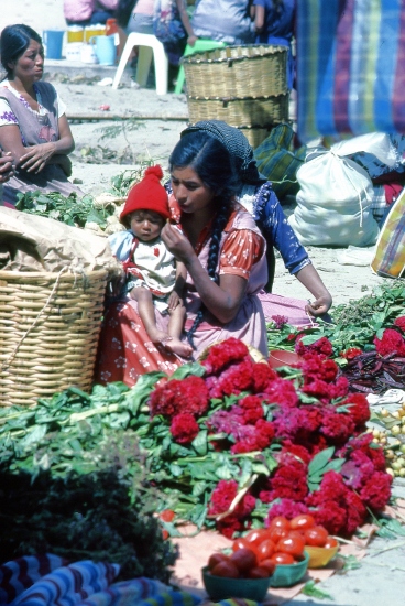
Mother and child in a Mexican market

Mother and child in a Mexican market. Photo: Tony Burton.

For decades, development experts have recognized that health, education and economic opportunity of mothers are crucially important to the quality of life of their children. Mothers’ level of education is often the most important factor.

The impacts last for numerous generations. Not only do the children of more educated mothers do better, but their grandchildren and great grandchildren also do better. On the other hand, malnourishment during the first 1,000 days is linked to low education and economic opportunity for the child. It can result in daughters getting pregnant earlier and having less healthy children. This vicious circle can continue for generations.

How does Mexico stack up with other major countries around the world? The results for Mexico are a bit mixed. From 1990 to 2010 Mexico recorded an impressive decrease in malnutrition of 3.1% per year. (The measure of malnutrition used in this comparison was children too short for their age, “stunting”). Mexico has cut malnutrition almost in half (47%) since 1990. This decrease ranks it 11th among the 165 countries analyzed. Much of this progress is associated with Mexico’s Oportunidades Program. The ten countries that did better than Mexico include China (6.3%), Brazil (5.5%), and Vietnam (4.3%). Fifteen countries suffered increases in malnutrition during the 20 year period, including Somalia (6.3%/year), Afghanistan (1.6%/year) and Yemen (1.0%/year).

On the other hand, the study points out that, given its level of Gross Domestic Product (GDP) per capita, Mexico’s level of malnutrition is higher than it should be. Other under-performers include the USA, Singapore, India, Indonesia, Guatemala, Peru, South Africa and Venezuela. These countries tend to have very inequitable distributions of income. Surprisingly, Brazil, with one of the worst levels of income inequality, was among the group of countries with lower malnutrition than expected given their GDP per capita. Other over-performers include Chile, Ukraine, China and Vietnam. Obviously, in all countries malnutrition is much worse among the poor.

The study divides the 165 countries into the three Tiers used by the United Nations. The Tiers are labeled I-“more developed”, II – “less developed” and III – “least developed”. Tier I is limited to Japan and European countries. Mexico is one of 80 countries in Tier II (“less developed” countries).

The UN has a “Women’s Health Index” for Tier II, comprised of lifetime risk of maternal death, percent of women using modern contraception, percent of births attended skilled attendant, and female life expectancy at birth. Within this group, Mexico ranks 19th in “Mother’s (Health) Index” compared to Cuba (ranked 1st), Argentina (4th), Brazil (12th), China (14th), South Africa (33rd), Turkey (47th), Iran (50th), Philippines (52nd), Indonesia (59th), Saudi Arabia (63rd), Egypt (65th), Guatemala (68th), India (76th), Pakistan 78th) and Nigeria (80th).

The differences between ranks appear to overstate the real differences. For example, the scores on the individual variables for Mexico (19th) and Argentina (4th) are relatively close. The chance of maternal birth-related death is one in 500 for Mexico versus 600 in Argentina. In Mexico 95% of births are attended by a trained worker compared to 98% in Argentina. Two thirds (67%) of Mexican women use modern contraception methods compared to 64% in Argentina. Life expectancy for women is 80 years in both countries.

The UN “Children’s Health Index” for Tier II is comprised of under age five mortality rate, percent of children under 5 moderately or severely underweight for age, gross primary enrollment ratio, gross secondary enrollment ratio and percent of population with access to safe drinking water.

Mexico ranks 18th among Tier II countries in terms of “Children’s (Health) Index” compared to Cyprus (1st), South Korea (2nd), Brazil (7th), Argentina (8th), Turkey (10th), Egypt (21st), Iran (26th), China (34th), South Africa (56th), Guatemala (63rd), Philippines (64th), Indonesia (70th), Pakistan (76th), India (77th) and Nigeria (82th). Here again, the differences between ranks appear to overstate the real differences.

While Mexico has made impressive progress concerning mother’s and baby’s health, it still lags behind Argentina and Brazil not to mention virtually all European countries. The biggest concern is rural areas of Mexico, especially southern Mexico, which seriously trail urban Mexico in terms women’s and child’s health. For example, infant mortality rates are highest in Chiapas, Oaxaca and Guerrero, followed by Veracruz, Hidalgo and Puebla. On the bright side, rural areas are making great progress thanks to programs like Oportunidades.

Happy Mother’s Day!


Update on the activity of Popocatepetl Volcano

 Mexico's geography in the Press  Comments Off on Update on the activity of Popocatepetl Volcano
May 102012
 

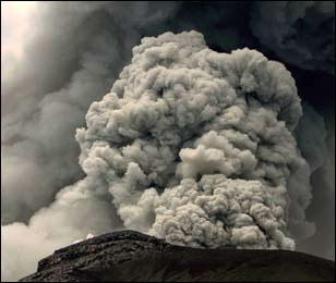
In the past few days, Popocatepetl Volcano has continued to emit gas, steam and ashes, periodically shooting ash-laden clouds high into the sky. The columns of ash have risen up to 2500 meters above the volcano before drifting downwind. Depending on the wind direction at the time, light falls of ash have been reported from Mexico City (especially the Milpa Alta and Iztapalapa districts) and the city of Puebla.

Ash cloud rises above Popocatepetl

Ash cloud rises above Popocatepetl Volcano

The National University’s Atmospheric Sciences Institute has developed atmospheric models taking account of the volcanic emissions and is releasing regular forecasts of where ash is likely to fall.

Ramón Espinasa Pereña, who heads the Geological Risks department in the National Disaster Prevention Centre (Centro Nacional de Prevención de Desastres, Cenapred) expressed concern recently that Popocatepetl Volcano could be headed towards much more significant activity in coming weeks.

In an interview with Mexico City daily Excelsior, Espinasa started by saying that that the current level of activity is less than that experienced in 2000 when the volcano’s heat caused the melting of the glacier then found on the northwest side of the mountain. However, he added, the situation today is quite different. The dome of lava inside the crater of Popocatepetl Volcano has been growing, increasing the risks of a significant and possibly explosive eruption. In 1994, prior to the 2000 eruption, the crater of the volcano was about 800 meters long, 600 meters wide and 100 meters deep. The activity in 2000 raised successive domes of lava in the crater to within 20 or 30 meters of the crater rim. So far this year, the depth of the crater has remained about the same, but only because almost all the new material being added to the existing domes is being blown into the air.

Experts are concerned that the high density of the magma beneath the volcano may lead to the existing vents being blocked. If this happens, pressure will build up underground and greatly increase the possibility of a violent eruption.

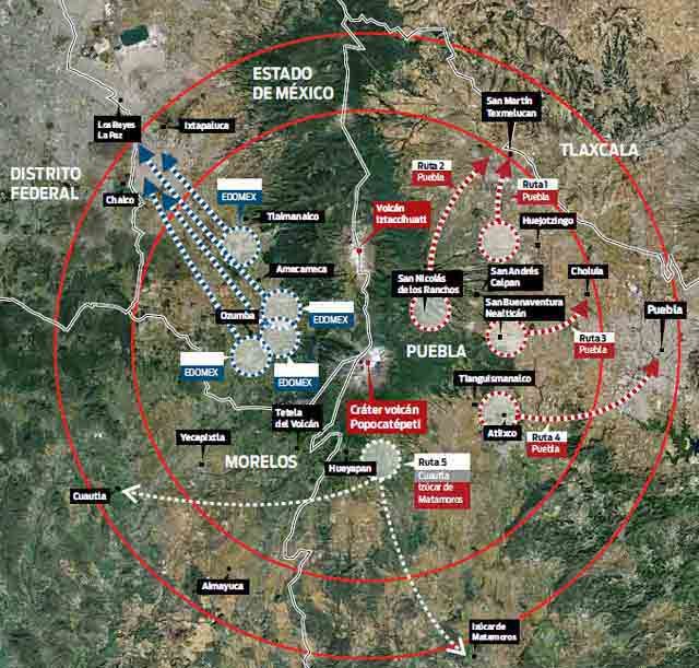
Evacuation plans have been in place since 1994, and they have been modified and updated regularly since. There are ten major evacuation routes (see map). The villages most at risk (inside the 12-kilometer radius “high risk” zone) include several in the states of Puebla (San Nicolás de los Ranchos, Santiago Xalitzintla, San Pedro Benito Juárez, San Baltazar Atlimeyaya and Tochimilco), Morelos (Ocuituco, Tetela del Volcán, Yecapixtla, Zacualpan de Amilpas and Temoac) and the State of México (Tepetlixpa, Ozumba, Atlautla, Ecatzingo and Amecameca).

Popocatepetl Volcano: the planned evacuation routes

Popocatepetl Volcano: the planned evacuation routes

Last week, the evacuation system (that will only be put into effect if the risk level rises) was tested with a large-scale practice evacuation in which the Mexican Army assisted municipal and state officials and emergency response crews. The practice has enabled authorities to improve the forecasts of precisely how long it will take to evacuate all villagers from the likely danger zone, in the event that the risk level is raised.

Evacuation will not be easy. Some local inhabitants argue that the volcano has never caused them any harm, because, on the contrary, it is their “protector and guide”. They are unlikely to move voluntarily even if an eruption is imminent. They hold a festival each year on 12 March thanking the volcano for its rich soil, abundant rainfall and “to keep the volcano calm and happy.” The ceremonies include the placing of offerings part-way up the volcano, accompanied by folk dancing.

Related posts:


The growth and expansion of Wal-Mart in Mexico

 Mexico's geography in the Press, Updates to Geo-Mexico  Comments Off on The growth and expansion of Wal-Mart in Mexico
May 052012
 

Much recent attention in the USA and Mexico has focused on the allegations of bribery related to Wal-Mart de México.  Interestingly, the company has a rather long history in Mexico. It started in 1958 when Jerónimo Arango and his brothers Placido and Manual started a company called Cifra and opened a deep discount store in Mexico City named Aurrera Bolivar. It was inspired by the E.J. Korvette discount store in New York City. The store was an immediate success, helped by sponsorship of the popular TV show, La Pregunta de los $64,000 pesos (“The $64,000 Pesos Question”).

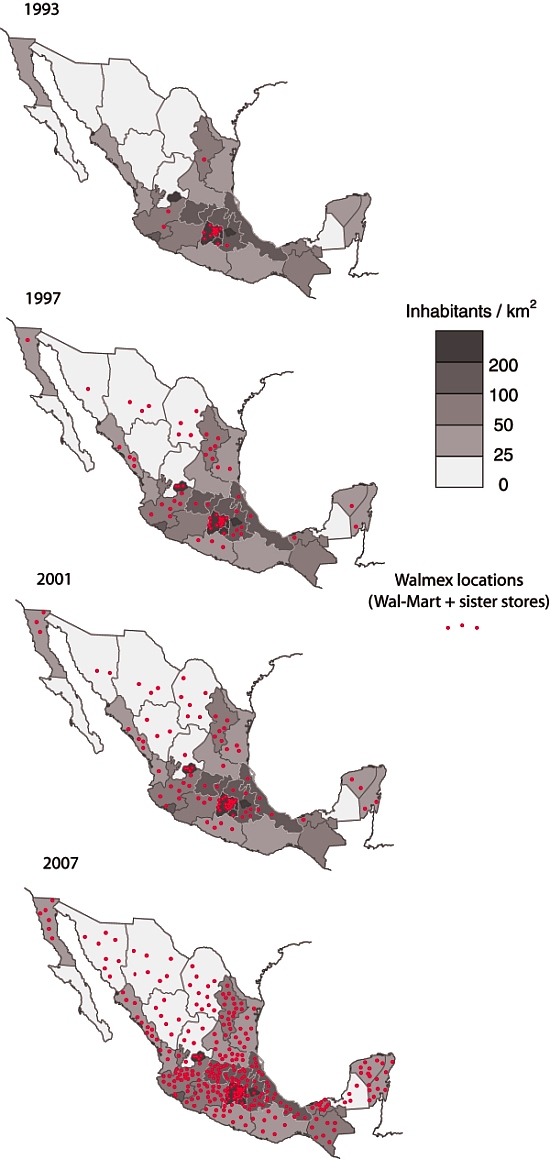
Wal-Mart's expansion across Mexico, 1993-2007

Wal-Mart's expansion across Mexico, 1993-2007. Click map to enlarge

By 1965 Cifra had eight Aurrera stores in the Mexico City area as well as a Superama grocery store and VIPS restaurant. Cifra and Jewel-Osco of Chicago formed a joint venture and by 1970 they opened the first Bodega Aurrera discount warehouse stores and Suburbia department stores. Their first hypermarket, Gran Bazar, followed in 1976. Shares in the company were sold to the public in 1977.   By serving low-income customers, the company managed to survive the financial crisis of 1982.  In fact during the 1980s it increased sales by an average 20% per year reaching US$550 million by 1989.

Rapid growth continued in the 1990s. By 1992 there were 38 Almacenes Aurrera supermarkets, 29 Bodega Aurreras, 34 Superamas, 29 Suburbias (department stores), 59 VIPS, as well as 15 El Portón restaurants. Almost all of these were located in the densely populated Mexico City and surrounding State of Mexico. Phenomenal growth continued in 1992 with 23 new units added. Cifra B shares increased forty-fold in just five years from the start of 1988 through the end of 1992. At that time, Cifra had a sophisticated, state-of-the-art data system for inventory control and monitoring customer preferences.

In 1991 Cifra formed a joint venture with the US firm Wal-Mart (founded in 1962, four years after Cifra). Unlike Cifra, whose early growth was based on an enormous urban area, Wal-Mart USA’s incredible early growth concentrated on rural areas. Initially the joint venture focused on trade and the members’ only Club Aurrera, which was soon renamed Sam’s Club. The first map shows the distribution of Wal-Mart stores in 1993. Expansion of new outlets throughout Mexico was only slightly slowed by the 1994 financial crisis.

By 1995, there were 22 Sam’s Clubs, and 11 Wal-Marts, 35 Almacenes Aurrera, 58 Bodegas Aurrera, 36 Superamas, 33 Suburbias, as well as 114 VIPS restaurants. One of the new Wal-Mart Supercenters was the largest in the world. The signing of NAFTA in 1994 strengthened the joint venture. In 1997 Wal-Mart USA acquired majority interest in Cifra creating Wal-Mart de Mexico or Walmex. The company, which previously had been heavily concentrated in Metro Mexico City, was soon aggressively opening new units in cities throughout the country (see maps).

Recent news reports allege that this aggressive growth may have been facilitated by payments of bribes to expedite construction permits. As of March 2012, Walmex was operating no fewer than 2,106 retail units throughout Mexico. They include 127 Sam’s Clubs, 213 Walmart Supercenters, 94 Suburbias, 385 Bodega Aurreras, 88 Superamas, 358 VIPS and El Portón restaurants, and over 840 Bodega Aurrera Expresses and other small outlets.

Wal-Mart de México is the country’s largest retailer, with sales of over US$24 billion, and largest private-sector employer, with 209,000 employees. These figures make Walmex the dominant player in its sector, well ahead of its Mexican supermarket rivals: Soriana ($8 billion); Comercial Mexicana (Mega, $4.5 billion) and Chedraui ($4.4 billion).

The 2007 map shows how Wal-Mart has now expanded into some areas where the population density is relatively low. The early expansion of Wal-Mart was into areas with high population density, where a single, well-placed store could easily be accessed by a lot of people, and therefore have the potential to be highly profitable. Even with the 2007 distribution, however, there is still a marked north-south divide in access to Wal-Mart, which reflects income disparities in Mexico.

In 2009/10 Walmex acquired Walmart Centroamérica and is now named Wal-Mart de México y Centroamérica, adding 622 retail outlets in Guatemala, El Salvador, Honduras, Nicaragua and Costa Rica, to bring the total number of units it operates (including Mexico) to 2, 728 retail outlets (with sales of about $29 billion) compared to Wal-Mart USA’s 4,468 outlets (with 2011 sales of $447 billion).

Source for maps:  

The maps have been redrawn, based on maps in “Supplier Responses to Wal-Mart’s Invasion of Mexico”  by Leonardo Iacovone, Beata Smarzynska Javorcik, Wolfgang Keller, James R. Tybout. Working Paper 17204  of the National Bureau of Economic Research, Cambridge, MA, USA.

Related posts


Happy “Cinco de mayo” (5 May)!

 Other  Comments Off on Happy “Cinco de mayo” (5 May)!
May 052012
 

Geo-Mexico wishes all readers a Happy “Cinco de Mayo” (5 May)! The holiday of Cinco de Mayo (5 May) commemorates the Battle of Puebla, fought on May 5, 1862. The battle marks Mexico’s only major military success since its independence from Spain in 1821. Today, in a curious example of cultural adaptation, the resulting holiday is actually celebrated more widely in the USA than in Mexico!

For an account of the history behind the Cinco de Mayo, and for an explanation of why the holiday is now celebrated more in the USA than in Mexico:

In Mexico, the Cinco de Mayo is celebrated with a parade in the City of Puebla each year, but, in another strange twist of geography,  the only re-enactment takes place in Mexico City:

May is a critical month in the 2012 wildfire season in Mexico

 Mexico's geography in the Press  Comments Off on May is a critical month in the 2012 wildfire season in Mexico
May 032012
 

This month is likely to be a critical month for wildfires. As we reported in an  earlier post – The geography of wildfires in Mexico: the disastrous wildfire season of 2011 – 2011 was Mexico’s worst year for wildfires for 30 years. The on-going drought in northern Mexico (the worst for 70 years) means that this year’s wildfire season is not likely to be any better.

May is the critical month because it marks the end of the dry season in most of Mexico, the time when the natural landscape looks parched. During the month of May, the landscape waits for the start of the rainy season, a season that is sometimes preceded by a spate of electrical storms. Electrical storms can trigger wildfires if they ignite the tinder-dry vegetation.

In the first four months of 2012, there have been some significant wildfires in several parts of Mexico, including one uncomfortably close to the Guadalajara Metropolitan Area, which has a population of almost 5 million.

Here is a brief round-up of the major wildfires in 2012 so far:

Durango

The largest single fire in the country so far in 2012 was in Potrerillos, in the municipality of Canatlán. It damaged 112 square kilometers (43 square miles). The 56 other wildfires experienced by Durango so far this year have all been small. The total area of the state damaged by wildfires this year currently stands at about 120 square miles.

Coahuila
Coahuila has experienced 30 fires so far this year, causing to more than 160 square kilometers. The latest three fires have been brought under control in the past few days. In the Sierra Salsipuedes (municipality of San Buenaventura) a wildfire destroyed 8 square kilometers of brush. Wildfires in the Sierra de la Madera (in the municipalities of Ocampo and Cuatrociénegas) damaged 37 square kilometers and 17 square kilometers respectively.

Sonora

So far in 2012, firefighters have fought 19 wildfires, affecting almost 40 square kilometers it total, mainly grassland and scrub, in the municipalities
of Yécora, Álamos, Rosario Tesopaco, Bacoachi, Quiriego, Nacori Chico and Cucurpe.

Jalisco

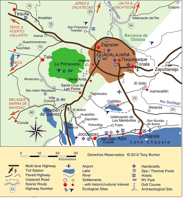
Some 1,000 firefighters battled for almost a week to bring a major wildfire in the Primavera Forest (Bosque de la Primavera) under control. The Primavera Forest is a partially-forested wilderness area with hot springs. It is set in a volcanic caldera on the western outskirts of Guadalajara, Mexico’s second largest city.

Location of Primavera Forest in relation to Guadalajara and Lake Chapala.

Location of Primavera Forest in relation to Guadalajara. Credit: Tony Burton; all rights reserved.

Initial reports say that the blaze began on 14 April when a garbage fire got out of control. By the time it was brought under control, the fire had damaged 85 square kilometers, about 35% of it forested, making it the worst fire in the area since 2005. That area damaged is about one-third of the total area of the Primavera Forest. Residents of Guadalajara were luckier than in 2005 because winds this time blew most of the smoke away from the city, so the city’s air quality was not seriously compromised. Even so, schools in some areas were closed briefly as a precaution.

The Primavera has a chequered history of protection. Most of the land is privately owned. It was declared a federally protected area in 1980, but ever since then real estate developers have nibbled away at the edges of the protected area, largely ignoring attempts by local officials to enforce zoning regulations.

Morelos
Several relatively small fires have damaged parts of this small state. The three most significant wildfires to date were in the municipalities of Tepoztlán, Tlalnepantla and Tlayacapan. They damaged 5 square kilometers of forest, but, because of the precipitous terrain, required the combined efforts over four days of more than 700 firefighters. The area, very close to Mexico City, is a popular weekend destination for city dwellers, and renowned for its ecotourism potential. Tepoztlán is one of Mexico’s Magic Towns.

Puebla
A small fire in Cerro del Palmar (in Liebres municipality) unfortunately resulted in two deaths, including that of a firefighter.

Oaxaca
More than 30 square kilometers have been damaged by wildfire this year in various parts of the state.

Related posts: