Jan 312013
 

The remote mountains and plateaus of the north-west corner of Jalisco where it shares borders with the states of Nayarit, Durango and Zacatecas (see map) is home to some 18,000 Huichol Indians, as well as their close cousins, the Cora.

The Huichol heartland (central part of the rectangle on map) is an area of about 4100 square kilometers which straddles the main ridges of the Western Sierra Madre, with elevations of between 1000 and 3000 meters above sea level. There are dozens of dispersed small Huichol rural settlements (ranchos) in the area. We will take a detailed look at their settlements and traditional way of life in a future post.

In this post we focus on the regional setting of the Huichol heartland and the links that now exist between the Huichol and other places in the same general region of Mexico.

huichol-regional-setting

The Huichol refer to all other Mexicans (whatever their ethnic origin) as “mestizo”. The nearest non-Huichol “mestizo” towns are  Mezquitic, Colotlán, Bolaños, Chimaltitán and Villa Guerrero, all in Jalisco, and all about 2-3 days’ walk from most Huichol settlements.

Migration to the tobacco fields

Many Huichol have left their home villages, where economic prospects are limited, in search of employment elsewhere. This kind of migration is often temporary or seasonal. For example, some Huichol undertake seasonal agricultural work, from November to May, on the tobacco plantations of coastal Nayarit. This may guarantee some income but the living conditions are poor, the work is hazardous and pesticide poisoning is all too common. Most of these Huichol return home each summer to plant their corn, beans and squash.

The center of tobacco cultivation is Santiago Ixcuintla, a town which has a very interesting support center for Huichol Indian culture and crafts. Tobacco cultivation, no longer as important as it once was, required as many as 15,000 local plus 27,000 temporary workers. While the businesses involved all have guidelines about how chemical sprays (including including Lannate, Diquat, Paraquat and Parathion) should be applied, these have rarely been effectively enforced. Many of the Huichol live in shanty-like accommodation in the fields, with no ready access to potable water. Some studies have shown that pesticide containers are sometimes used to carry drinking water. There have also been many cases of organophosphate (fertilizer) intoxication from working and living in the tobacco fields.

The tobacco workers often have no place to purchase basic food supplies apart from a store run by the same company they work for. The company holds their wages until the end of the week, and deducts the cost of any items they have bought. This is a virtually identical system to the “tienda de raya” system that was employed by colonial hacienda owners to economically enslave their workers.

Making the pesticide problems for the Huichol even worse is the fact that chemicals including DDT have been used to fumigate parts of Sierra Huichol in order to kill malarial mosquitoes. The Huichol refer to the DDT sprayers as “matagatos” (cat killers). The effects of most of these chemicals are cumulative over time.

Movement to the cities

In the past thirty years, about four thousand Huichols have migrated to cities, primarily Tepic (Nayarit), Guadalajara (Jalisco) and Mexico City. It has also become quite common to see Huichol Indians (usually the menfolk in their distinctive embroidered clothing) in tourist-oriented towns, such as San Blas and Puerto Vallarta. To a large extent, it is these city-wise Huichols who, in search of funds, have drawn attention to their rich culture through their artwork and handicrafts. In addition to embroidered bags and belts, the Huichol make vibrant-colored bead work, yarn crosses and (more recently) yarn paintings, often depicting ancient legends. Income from artwork is very variable, but it is an activity that can include the participation of women. However, trading may depend on middle men who siphon off potential profits, and the Huichol artists now face stiff competition from non-Huichol imitators.

Encroachment by outsiders

As we saw in an earlier post—The sacred geography of Mexico’s Huichol Indians—the Huichol consider themselves the guardians of a large part of western Mexico. Inevitably, traditional Huichol lands have been encroached upon by outsiders for agriculture and ranching. Some non-Huichol ejidos have been established on land that was formerly communal Huichol land. Unfortunatley, the Huichol have had little defence against these pressures.

Mining interests are also threatening some traditional Huichol areas. For example, there is a serious dispute between the Huichol and the First Magestic Silver company over the area the Huichol call Wirikuta (where they gather their sacred peyote on an annual 800-km round-trip pilgrimage). First Majestic Silver has obtained permission from the Mexican government for its proposed La Luz Silver Project, which will extract silver from the Sierra de Catorce, despite this area’s historic significance for the Huichol.

Want to see their artwork?

One of the museums in the city of Zacatecas houses one of the relatively few museum quality displays of Huichol Indian art anywhere in Mexico. The collection was bought by the Zacatecas state government, in order to prevent its sale to the University of Colorado. The 185 embroideries (as well as many other items) were collected by Dr. Mertens, an American doctor who lived in Bolaños and worked for the Bolaños mining company. After the company closed its mines, Mertens continued to live in Bolaños, and to offer medical services to the Huichol, asking only for the occasional embroidery in lieu of payment. Another place to see high quality Huichol art is the small museum in the Basilica de Zapopan in the Guadalajara Metropolitan Area.

Related posts:

The distinctive street pattern of Venta de Bravo, Michoacán

 Other  Comments Off on The distinctive street pattern of Venta de Bravo, Michoacán
Jan 262013
 

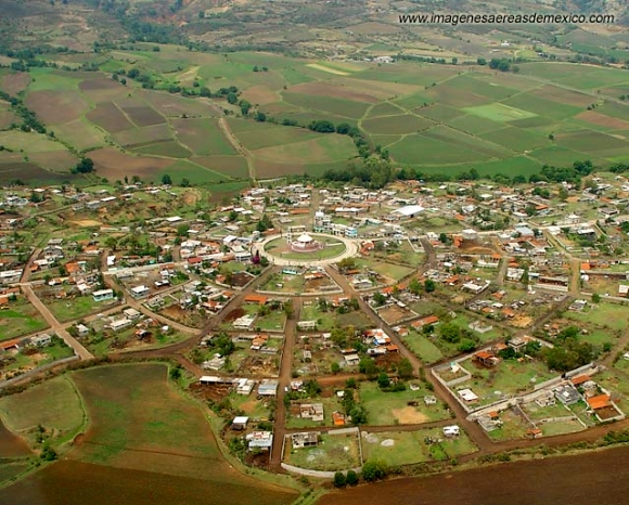
The small settlement of Venta de Bravo, in the municipality of Contepec in the state of Michoacán, has a very distinctive street pattern. As the image shows, it has a circular “center”, surrounded by a series of concentric circular streets (see image), connected via regularly-spaced radial streets. The regularity of the pattern is not quite perfect. Based on the photo, the imperfections probably result from variations of topography.

Venta de Bravo, Michoacán. Credit: imagenesaereasdemexico.com

Venta de Bravo, Michoacán. Credit: imagenesaereasdemexico.com

The village has about 1300 inhabitants and is at an elevation of 2290 meters above sea level. This is clearly a “planned settlement”, and one almost certainly quite modern in origin. I haven’t ever visited Venta de Bravo and don’t know its history, but would certainly be interested in finding out more if you have any pertinent information or can suggest likely sources.

An online search for Venta de Bravo will turn up numerous articles about the seismically active 45-km-long Venta de Bravo fault, as well as references to the small “Rayón National Park” which is only a few kilometers away in the Sierra of Tlalpujahua and extends as high as 2770 meters above sea level (Cerro del Gallo).

The sacred geography of Mexico’s Huichol Indians

 Other  Comments Off on The sacred geography of Mexico’s Huichol Indians
Jan 242013
 

The remote mountains and plateaus where the states of Jalisco, Nayarit and Zacatecas all meet is home to some 18,000 Huichol Indians, as well as their close cousins, the Cora. The Huichol (Wixárika = “the healers” in their own language) live in scattered, extended family, settlements (ranchos) and rely entirely on oral tradition. They are intensely religious, and see their time-honored responsiblity as protecting nature’s creations. Their shamen perform elaborate ceremonies to a pantheon of gods to ensure  bountiful crops, health and prosperity, as well as to preserve nature and heal the Earth.

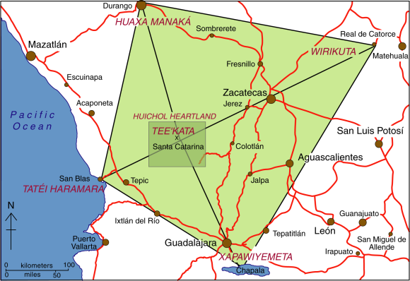
The center of the Huichol world – Tee’kata (see map) – coincides with the village of Santa Catarina in the Huichol heartland. Central to some Huichol ceremonies is peyote, an hallucinogenic cactus, obtained from an annual pilgrimage eastwards to the sacred land of Wirikuta, near Real de Catorce in San Luis Potosí. The pilgrimage is an 800 km (500 mile) round trip. Peyote (Lophophora williamsii) is called jicuri by the Huichol.

Map of the sacred geography of Mexico's Huichol Indians

The sacred geography of Mexico’s Huichol Indians. Credit: Tony Burton/Geo-Mexico; all rights reserved.

Equally important points in the Huichol cosmos lie to the north, west and south:

  • north: Huaxa Manaká =  the mountain of Cerro Gordo in Durango
  • west: Tatéi Haramara = the Isla del Rey, an island near San Blas
  • south: Xapawiyemeta =  Scorpion Island (Isla de los Alacranes) in Lake Chapala

The sacred geography of the Huichol (shown by the rhombus on the map) echoes the significance they attach to the number 5. They view the world as having five regions, corresponding to five mothers (one under the earth and the other four at cardinal points). They believe that the sun is carried through the universe by five serpents. The flowers of their sacred peyote come in five colors, as do their cobs of corn  (Blue, white, reddish purple, yellow, multicolor). The Huichol have different terms for the five colors of corn, which are closely associated with the five main points of their cosmos:

  • yuawime – blue – south
  • tuxame – white- north
  • ta+lawime  – purple – west
  • taxawime – yellow – east
  • tsayule – multicolor – center

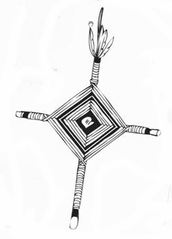
huichol-yarn-crossEvery rhombus has four corner points and a center. Their traditional yarn crosses (often mistakenly referred to as “God’s Eyes”) are made by wrapping colored yarn around two twigs to form a rhombus of color. Most yarn crosses use several different colors. Compound yarn crosses are made by adding small yarn crosses at each end of the two main supporting twigs, giving five crosses (eyes) in total. Huichol fathers will make a simple yarn cross when a child is born, adding additional crosses annually until the yarn cross is considered complete. This, of course, is assuming that the child survives, given that infant mortality among the Huichol is very high.

The colors used in Huichol artwork also carry lots of symbolism. For example, blue is taken to mean water or rain and associated with Lake Chapala to the south. Black symbolizes death and is linked to the Pacific Ocean in the west. Red, the color for mother, is usually reserved for sacred places such as Wirikuta in the east. White (clouds) is associated with the north.

Related posts:

Mexico’s Magic Town program loses its shine

 Other  Comments Off on Mexico’s Magic Town program loses its shine
Jan 212013
 

Regular readers will be well aware of our concern about the number of towns in Mexico designated Magic Towns in the past few months. As we have written previously, some of the towns chosen are far from “Magic” and offer very little indeed of interest to any regular tourist.

Not content with devaluing the program by some dubious choices, at the end of November 2012, the outgoing administration of President Felipe Calderón rushed through the designation of no fewer than 17 more towns in its last few days in office, to bring the total number of Magic Towns to 83.

Added to the list at the end of November 2012 were:

  • 67   Tacámbaro, Michoacán
  • 68    Calvillo  Aguascalientes
  • 69    Nochistlán, Zacatecas
  • 70    Jiquilpan, Michoacán
  • 71    Tlatlauquitepec, Puebla
  • 72    Tzintzuntzan, Michoacán
  • 73    Mapimí, Durango
  • 74    Papantla, Veracruz
  • 75    Tecate, Baja California
  • 76    Arteaga, Coahuila
  • 77    Viesca, Coahuila
  • 78    Jalpa de Cánovas, Guanajuato
  • 79    Salvatierra, Guanajuato
  • 80    Yuriria, Guanajuato
  • 81     Xicotepec, Puebla
  • 82     Jala, Nayarit
  • 83     El Rosario, Sinaloa

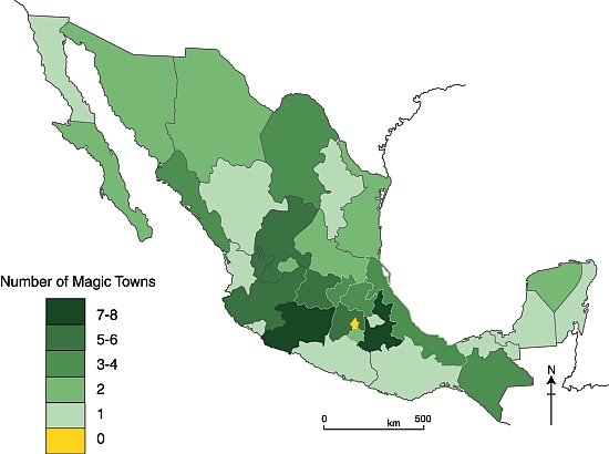
The considerable charms of Mapimí, Durango were described in a previous post. Several of the latest towns to be included are well worthy of Magic Town status, but others are not. In future posts, we will take a closer look at some of the other towns on this list, and their relative merits for inclusion as Magic Towns. For now, we content ourselves with presenting an updated map of the distribution of Mexico’s Magic Towns, as of 1 January 2013:

Mexico's Magic Towns, as of 1 December 2012. Credit: Tony Burton / Geo-Mexico

Mexico’s Magic Towns, as of 1 December 2012. Credit: Tony Burton / Geo-Mexico

The domination of central and western Mexico is clear. All states (excluding the D.F.) now have at least one Magic Town, but southern Mexico still appears to be somewhat undervalued in terms of its cultural tourism potential.

Note: Four towns in the latest list—Tacámbaro, Jiquilpan and Tzintzuntzan (all in Michoacán) and Jala (in Nayarit)—are described in the recently published 4th (Kindle/Kobo) edition of my “Western Mexico: A Traveler’s Treasury” (Sombrero Books, 2013). The book describes no fewer than 17 of Mexico’s Magic Towns as well as several more (such as Ajijic and Bolaños) that are reported to have begun their approval process.

Related posts:

Mexico City wins 2013 Sustainable Transport Award

 Mexico's geography in the Press  Comments Off on Mexico City wins 2013 Sustainable Transport Award
Jan 192013
 

The Institute for Transportation and Development Policy (ITDP), together with an international committee of transportation and development experts, has awarded Mexico City the 2013 Sustainable Transport Award.

The Institute for Transportation and Development Policy works with cities worldwide to bring about sustainable transport solutions that cut greenhouse gas emissions, reduce poverty, increase urban mobility and improve the quality of urban life.

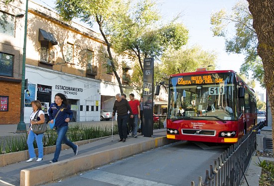
The 2013 Sustainable Transport Award recognizes Mexico City’s Bus Rapid Transit (BRT) system, cycling and walking infrastructure, parking program, and revitalization of public space. Established in 2005, the Sustainable Transport Award recognizes leadership and visionary achievements in sustainable transportation and urban livability, and is presented to a city each January for achievements in the preceding year.

Mexico City Metrobus

The Sustainable Transport Award was presented to Mexico City on January 15, 2013 at an awards ceremony during the annual meeting of the Transportation Research Board, one of six major divisions of the U.S. National Research Council. ITDP board president and former Mayor of Bogotá Enrique Peñalosa presented Mexico’s Minister of Transport, Rufino León, and Minister of Environment, Tanya Muller with the award. The former Mayor of Mexico City, Marcelo Ebrard, who oversaw much of Mexico City’s sustainable transport projects, made closing remarks at the ceremony. Janette Sadik-Khan, Commissioner of the New York City Department of Transportation, delivered the keynote address.

Mexico City has implemented many projects in 2012 that have improved livability, mobility, and quality of life for its citizens, making the Mexican Capital a best practice for Latin America.

  • The city expanded its Bus Rapid Transit system, Metrobús, with Line 4, running along a corridor from the historic center of the city to the airport.
  • The city piloted a comprehensive on-street metered parking program, EcoParq.
  • The city opened line 12 of its Metro system (Sistema de Transporte Colectivo Metro).
  • The city expanded its successful public bike system Ecobici, and added new bike routes (ciclovías).
  • The city revitalized public spaces including the Alameda Central and Plaza Tlaxcoaque.

The finalists and winner were chosen by a Committee that includes the most respected experts and organizations working internationally on sustainable transportation. The Committee includes the Institute for Transportation and Development Policy, The World Resources Institute Center for Sustainable Transport,  GIZ (Deutsche Gesellschaft für Internationale Zusammenarbeit), Clean Air Asia, Clean Air Institute, United Nations Centre for Regional Development (UNCRD), Transport Research Laboratory, EcoMobility, Local Governments for Sustainability (ICLEI) and the Transport Research Board’s Transportation in the Developing Countries Committee.

“Mexico City was like a patient sick with heart disease, its streets were some of the most congested in the world”, says Walter Hook, CEO of ITDP, “In the last year, Mexico City extended its great Metrobus BRT system straight through the narrow congested streets of its spectacular historical core, rebuilt public parks and plazas, expanded bike sharing and bike lanes, and pedestrianized streets.  With the blood flowing again, Mexico City’s urban core has been transformed from a forgotten, crime ridden neighborhood into a vital part of Mexico City’s future.”

“We congratulate the Federal District of Mexico for their leadership in advancing sustainable transport. Celebrating success is a way to highlight best practices; many cities will find inspiration in your great achievements.”

“Sustainable transport systems go hand in hand with low emissions development and livable cities. Mexico City’s success has proven that developing cities can achieve this, and we expect many Asian cities to follow suit,” says Sophie Punte, Executive Director of Clear Air Asia.

Past winners of the Sustainable Transport Award include:  Medellín, Colombia and San Francisco, United States (2012); Guangzhou, China (2011);  Ahmedabad, India (2010); New York City, USA (2009); London, UK (2008); Paris, France (2008); Guayaquil, Ecuador (2007); Seoul, South Korea (2006), and Bogotá, Colombia (2005).

[Note: This post is based on the text of a press release from the The Institute for Transportation and Development Policy (ITDP)]

Related posts:

Why Is Mexico in the OECD?

 Other  Comments Off on Why Is Mexico in the OECD?
Jan 172013
 

The Organisation for Economic Co-operation and Development (OECD) was founded in 1961 to promote economic growth. Its current 34 members include 25 European countries along with Canada, the USA, Australia, New Zealand, Japan, South Korea, Mexico, Chile and Israel. Mexico joined the group in 1994. Four new members were admitted in 2010: Chile, Slovenia, Estonia and Israel. Russia is not yet a member but is moving toward that goal. The current Secretary General of the OECD is Mexico’s  José Ángel Gurría Treviño, first appointed in 2006; his current term in this position extends to 2016.

oecd_logo

OECD member countries are among the most highly developed and wealthiest countries on the planet. Though OECD members represent only 18% of the world’s population, they account for 55% of global Gross Domestic Product (GDP), measured on a Purchasing Power Parity (PPP) basis. Among OECD members, Mexico has the lowest per capita GDP, slightly behind Chile and Turkey. In terms of the UN Human Development Index (HDI) Mexico trails all the others except Turkey. How did Mexico become a member of this very elite set of countries?

There are three main criteria for OECD membership:

  1. Democracy and respect for human rights
  2. Open market economy
  3. GDP per capita (PPP) at least as high as the poorest OECD member

When Mexico became a member in 1994, it was a democracy albeit a one party democracy. It was very clearly an open market economy and its per capita GDP was slightly higher than Turkey’s. Consequently, it met the criteria and was admitted by other OECD members. (See Elżbieta Czarny et al., The Gravity Model and the Classification of Countriesin Argumenta Oeconomica, 2 (25) 2010.)

What are the benefits of OECD membership?

As a member, Mexico fully participates in OECD discussions concerning economic, social and environmental situations, issues, experiences, policies, and best practices. OECD collects and analyzes a very wide range of data which enables Mexico to monitor its position and progress on numerous important dimensions. OECD also has numerous world class experts and committees that can assist countries on specific issues and policies.

Certainly being a member of this elite group provides Mexico with an amount of international prestige. On the other hand, most development analyses and comparative OECD reports show Mexico near the bottom on most measures and rankings.

Related posts:

Colima Volcano erupts, destroying lava dome first created in 2007

 Mexico's geography in the Press  Comments Off on Colima Volcano erupts, destroying lava dome first created in 2007
Jan 142013
 

Colima Volcano (aka the Volcán de Fuego) is one of the westernmost volcanoes in Mexico’s Volcanic Axis, which straddles the country from west to east. The Volcano’s summit is only 8 km (5 miles) from the inactive Nevado of Colima volcano, Mexico’s sixth-highest peak, which rises 4260 m (13,976 ft) above sea level. (Curiously, despite their names, the summits of both volcanoes are actually located in the state of Jalisco and not the state of Colima.)

The elevation of Colima Volcano is officially given as 3820 m (12,533 ft) above sea level. In the past 400 years, it has been the most active volcano in Mexico, having erupted at least 30 times since 1576.

It is also considered to be one of the country’s most dangerous volcanoes. Numerous villages in its shadow keep a wary eye on its level of activity, and emergency evacuations have become a regular event in the past fifty years.

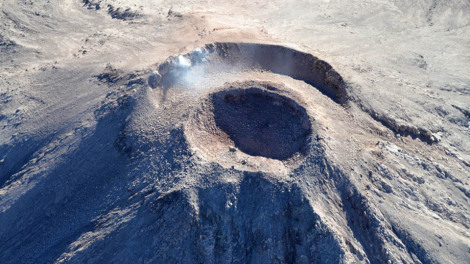
Colima Volcano, 11 Jan 2013. Photo: Protección Civil.

Colima Volcano forms new crater, 11 Jan 2013. Photo: Edo de Jalisco Protección Civil.

On a geological time-scale, the volcano first erupted about five million years ago in the Pliocene period, long after activity ceased at the nearby, and higher, Nevado de Colima. It quickly developed into a large volcano which partially blew apart or collapsed during Pleistocene times to form a caldera, five kilometers across. A new cone developed inside the caldera. This is the Volcán de Fuego we see today.

The cone is built mainly of pyroclastic materials (ashes and volcanic bombs) of andesitic composition together with some basaltic lava, making it a classic example of a composite volcanic cone.

Historically, the eruptions of the volcano have fallen into a definite cyclical pattern with periods of activity, each lasting about 50 years, interspersed with periods of dormancy. The first cycle of activity (after the Spanish arrived in Mexico) was between 1576 and 1611. Major eruptions occurred in 1680 and 1690, and further complete cycles occurred between 1749 and 1818, and from 1869 to 1913. Most geologists agree that current activity is part of the fifth cycle, which began in 1961.

A three year sequence of prior activity (2003 to 2005) is shown on this series of NASA satellite images.

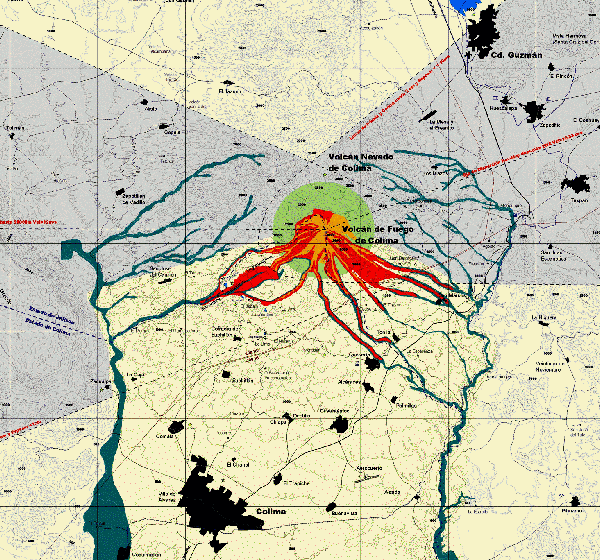
Hazard Map of Colima Volcano (2003) Credit: Universidad de Colima, Observatorio Vulcanológico

Hazard Map of Colima Volcano (2003) Credit: Universidad de Colima, Observatorio Vulcanológico. Click for full-size image (large file size)

In each major cycle, the first results of renewed activity force new lava into the existing crater, forming a dome. Once the crater has filled up, any additional lava is ejected from the crater and flows down the volcano’s flanks. If the lava is unable to escape (relieving the underground pressure), the dome is liable to explode, which is exactly what happened a few days ago:

As on several previous occasions, once the subterranean pressure that caused the activity has been relieved, activity should cease, and the volcano will enter another less dangerous dormant phase. Even during this phase, a plume of hot gas often billows out from the volcano.

The dome that was destroyed in January 2013 began to build in 2007. The explosive activity on 6 January and 10 January 2013 left behind a new crater 220 meters (720 ft) across and about 50 m (165 ft) deep. According to the Jalisco-Colima Scientific Committee (which oversees the hazard analysis posed by the volcano), the events of 6 and 10 January emitted an estimated  1.5 million cubic meters of material, which formerly formed the dome. The 10 January explosion, which occurred at 21:40 hrs local time, sent incandescent material down the west flank of the volcano. An ash column rose about 3000 meters into the air before traveling north-eastwards on the wind towards the city of Ciudad Guzmán.

Thermal imaging shortly after the 10 January explosion showed that the temperatures in the crater are below 200 degrees Centigrade, which indicates relatively little gaseous build up and limited risk of further major explosions. Even so, a prudent 7.5 km exclusion zone is being maintained around the volcano.

Update (29 Jan 2013):

Another explosion at 3:58 am on 29 January 2013 created a plume of ash and cinders that rose more than 3000 meters above the volcano. The ash fell of nearby villages, including Los Mazos, Ejido Atenquique, Tuxpan and Huescalapa.

The area around the volcanoes is described in more detail in chapter 15 of “Western Mexico, a Traveler’s Treasury” (4th edition; Sombrero Books, 2013).

Related posts:

Street patterns in Mexico City

 Books and resources  Comments Off on Street patterns in Mexico City
Jan 102013
 

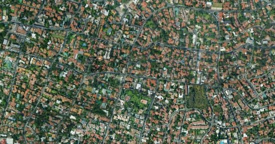
A recent post on Polis, “a collaborative blog about cities across the world”, focuses on the street patterns in Mexico City.

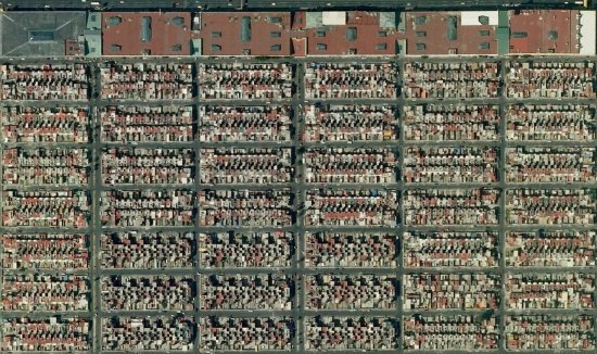
The post uses Google Earth images of different parts of the city to illustrate how street patterns vary between neighborhoods with different levels of wealth. This approach has long been used in urban geography, but the examples provided are a useful reminder of the value of “old-school” map interpretation skills, some of which are rapidly being lost in the age of online maps.

Mexico City Metropolitan Area: Fuentes de Aragón

Mexico City Metropolitan Area: Fuentes de Aragón

A simple exercise for students would be to ask them to choose two similar-sized cities, one in the USA and one in Mexico, and then use Google Maps and Google Earth images to compare their urban morphology (street patterns). It is worth comparing areas of different land uses (such as industrial, commercial, residential). The analysis should include some annotated images highlighting the key similarities and differences.

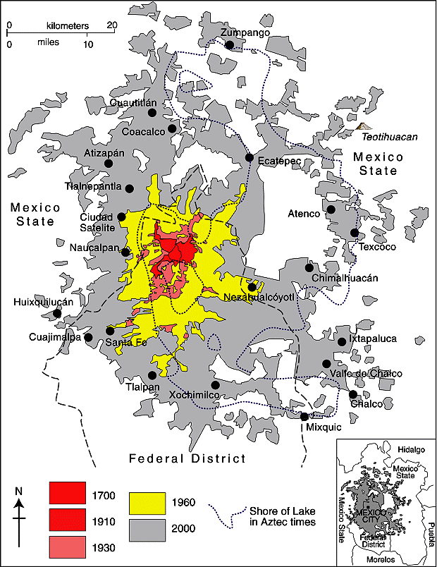
Mexico City Metropolitan Area (Geo-Mexico Fig 22.2; all rights reserved)

Spatial growth of Mexico City Metropolitan Area (Geo-Mexico Fig 22.2; all rights reserved)

The striking rectilinear lines usually found in poorer neighborhoods are in stark contrast to the curvilinear street patterns common in wealthier suburbs. In a city with a long history, like Mexico City, it is easy to locate and identify residential areas of very different age. (In general, the older residential areas are closer to the city center than newer residential areas.)

Mexico City: Pedregal San Angel

Mexico City: Pedregal San Angel

In the case of both Mexico City and Guadalajara (Mexico’s second largest city), a transect across the city from the wealthy west to the much poorer east will reveal remarkable differences in street patterns, corresponding closely to the patterns of wealth.

Related posts:


Globalization: Mexico exports almost all motor vehicles it produces, but imports new cars

 Updates to Geo-Mexico  Comments Off on Globalization: Mexico exports almost all motor vehicles it produces, but imports new cars
Jan 082013
 

Which company exports the most motor vehicles in Mexico? In term of units exported, Ford was the leader with 449,925 units. Ford exported over 97% of the vehicles it made in Mexico in 2011. Though Ford sold many new cars in Mexico, virtually all were imports, mainly from the USA or Canada. GM was a relatively close second with 443,237 vehicles exported, 81% of the total produced.

VW was next with 439,925 units exported, 84% of their total. Nissan was fourth with 411,660 vehicles exported which was a significantly lower percentage (68%) of its total production. Nissan sells about a third of its Mexican produced vehicles in Mexico, by far the highest percentage among auto manufacturers in Mexico.

Chrysler/Fiat exported 266,117 vehicles, 79% of their total production. Toyota was next with 49,549 vehicles exported for an amazing 99.9% of the total manufactured. Surprisingly only 47 of the almost 50,000 Toyotas made in Mexico in 2011 were sold in Mexico; all of the rest were exported to the USA or Canada. Virtually all of the thousands of new Toyotas sold in Mexico are imported. This is a very extreme case of globalization at work under NAFTA. Honda exported 36,429 units in 2011 for 80% of its total production.

Data are not yet available to determine which companies will lead in exports in 2012 and the percentage of total production that is exported. Overall production is expected to rise by over 20% in 2012 and perhaps even faster in future years judging by the amount auto companies are currently investing in Mexico. Obviously, production levels in 2013 and beyond will be closely tied to demand in the USA and Canada.

Related posts:

Mexico’s changing urban landscape: the rapid rise of low-income subdivisions

 Books and resources  Comments Off on Mexico’s changing urban landscape: the rapid rise of low-income subdivisions
Jan 052013
 

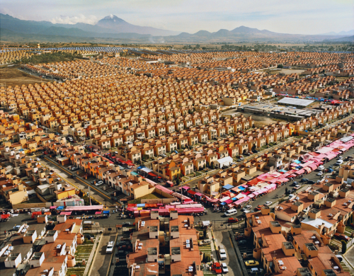
Between 2000 and 2006, more than 2.3 million new low-income INFONAVIT homes were built in Mexico, a staggering rate of 2,500 new homes each and every day. The achievement was documented by photographer Livia Corona, who divides her time between New York and Mexico City, in a four-year project entitled “Two Million Homes for Mexico”. The project focuses on the “surge of mass-scale neighborhood developments in Mexico, exploring their role in the ongoing transformation of the ecological, social and cultural landscape of the nation and its citizens.”

47,547 Homes. xtapaluca, Mexico.Credit: Livia Corona.

47,547 Homes. Ixtapaluca, Mexico.Credit: Livia Corona.

As Corona’s photos reveal, while most of the “cookie-cutter” housing developments lack public amenities (schools, clinics) and public spaces (parks), and have few commercial establishments, the people moving into these homes proved remarkably adaptable and creative.

In the photographer’s own words, “Through images, films, and interviews, I look for the space between promises and their fulfillment. In my photographs of multiple developments throughout the country, I consider the rapid redefinition of Mexican “small town” life and the sudden transformation of the Mexican ecological and social landscape. These urban developments mark a profound evolution in our way of inhabiting the world.”

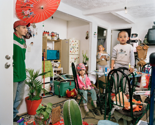
Credit: Livia Corona.

Credit: Livia Corona.

As she explained in an interview with Nina Corvallo for the  now-retired Nymphoto blog:

“In my current role as a visual artist, I am often familiarizing with new geographies, both for research and for commissioned assignments. My work is drawn by the underlying structures affecting quotidian survival, and my photographs expand on how these manifest on a broader level.”

“In my current work, Two Million Homes for Mexico, my drive comes from the riddle of what living in these neighborhoods can do to the development of a social and creative expression. What are the manifestations of this experience on the young minds growing up in these insular and remote landscapes, as they draw from a singular cultural and socio-economic backdrop?”

“Developers provided infinite rows of identical 100 to 200 square feet homes. Dwellers are now faced with the task of turning the rows into streets and developments into cities. I am inspired by the inventiveness of people in these neighborhoods, who are adapting with a very hands-on approach—despite a limited infrastructure—to procure a more appropriate living environment. Mexicans, as other Latin Americans, are notoriously gifted in appropriating the built environment. My project both celebrates these small individual triumphs as it frames the challenges and abuses made in providing housing for an ever-expanding population.”

The powerful images of Livia Corona are a worthy resource for urban geography classes.

Related posts:

Education quality: How do Mexican students compare to those in other countries?

 Other  Comments Off on Education quality: How do Mexican students compare to those in other countries?
Jan 032013
 

Mexico’s future is largely dependent on the quality of future citizens and consequently on the quality of its current education system. The Mexican economy has done quite well in recent years because it has a productive work force that is willing to work for relatively reasonable wages. While China previously had a workforce productivity advantage over Mexico, that advantage has essentially vanished. Therefore, many companies are moving their manufacturing operations from China to Mexico.

The Programme for International Student Assessment (PISA), coordinated by the OECD, evaluates national education systems every three years by testing 15-year-olds in reading, mathematics and science. The most recent assessment in 2009 investigated students in 65 countries, including the mostly high income 34 OECD countries.  (The 2012 results will be released in December 2013).

In 2009, the following countries ranked in the top ten in all three categories (reading, mathematics and science):

  • China: Shanghai (PISA divides China into several sub-national regions)
  • South Korea
  • Finland
  • Hong Kong
  • Singapore
  • Canada
  • Japan

How do Mexican 15-year-olds stack up against students from these other countries?

Within this group, the Mexican students ranked 48th in reading with a score 425. This placed Mexico behind the USA (17th, 500), Turkey (41st, 464), Russia (43rd, 459) and Chile (44th, 449); but ahead of Colombia (52nd, 413), Brazil (53rd, 412), Indonesia (57th, 402), Argentina (58th, 398) and Peru (63rd, 370). We mention the ranking and score of the USA because there has been considerable information published recently about the mediocre quality of its education system. While Mexico’s ranking and score is way behind that of the USA and closer to the bottom of this 65 country sample, it is not really so bad. It is better than that of most other Latin American countries. On the other hand it could and should be better.

The Mexican students did not do quite as well in mathematics. They ranked 50th with a score of 419. This placed them significantly behind the USA (31st, 487) and Russia (38th, 468). Mexico was also below Turkey (43rd, 445) and just behind Chile (49th, 421). As with reading they were ahead of Argentina (55th, 388), Brazil (57th, 386), Colombia (58th, 381), Indonesia (61st, 371) and Peru (64th, 360). Only one country was below Peru, namely Kyrgyzstan (65th, 331). It is important to remember that this sample includes mostly European countries, only one African country, Tunisia; no South Asian Countries, and only two Middle Eastern countries, Israel and Dubai. Mexico would look considerably better if it were compared with all countries in the world.

Mexico did about as well in science as they did in mathematics. They ranked 50th with a score 416. This placed them far behind the USA (23rd, 502) and Russia (39th, 478) and a ways below Turkey (43rd, 454) Chile (44th, 447). As with reading they were ahead of Brazil (53rdh, 405), Colombia (54th, 402), Argentina (56th, 401), Indonesia (60st, 383) and Peru (64th, 369). The data suggest that the scores for each country on reading, mathematics and science are pretty much the same within each country. In other words, the scores on any one of these disciplines tend to be a rather good measure of the overall quality of the education system.

If Mexico is going to compete in the globalized world economy, it must continue to improve its education system. Recent efforts have accomplished a great deal, raising the average amount of schooling of its citizens to 8.6 years. Future efforts should focus as much attention on improving the quality of education.

Related posts: