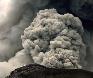
In the past few days, Popocatepetl Volcano has continued to emit gas, steam and ashes, periodically shooting ash-laden clouds high into the sky. The columns of ash have risen up to 2500 meters above the volcano before drifting downwind. Depending on the wind direction at the time, light falls of ash have been reported from Mexico City (especially the Milpa Alta and Iztapalapa districts) and the city of Puebla.
The National University’s Atmospheric Sciences Institute has developed atmospheric models taking account of the volcanic emissions and is releasing regular forecasts of where ash is likely to fall.
Ramón Espinasa Pereña, who heads the Geological Risks department in the National Disaster Prevention Centre (Centro Nacional de Prevención de Desastres, Cenapred) expressed concern recently that Popocatepetl Volcano could be headed towards much more significant activity in coming weeks.
In an interview with Mexico City daily Excelsior, Espinasa started by saying that that the current level of activity is less than that experienced in 2000 when the volcano’s heat caused the melting of the glacier then found on the northwest side of the mountain. However, he added, the situation today is quite different. The dome of lava inside the crater of Popocatepetl Volcano has been growing, increasing the risks of a significant and possibly explosive eruption. In 1994, prior to the 2000 eruption, the crater of the volcano was about 800 meters long, 600 meters wide and 100 meters deep. The activity in 2000 raised successive domes of lava in the crater to within 20 or 30 meters of the crater rim. So far this year, the depth of the crater has remained about the same, but only because almost all the new material being added to the existing domes is being blown into the air.
Experts are concerned that the high density of the magma beneath the volcano may lead to the existing vents being blocked. If this happens, pressure will build up underground and greatly increase the possibility of a violent eruption.
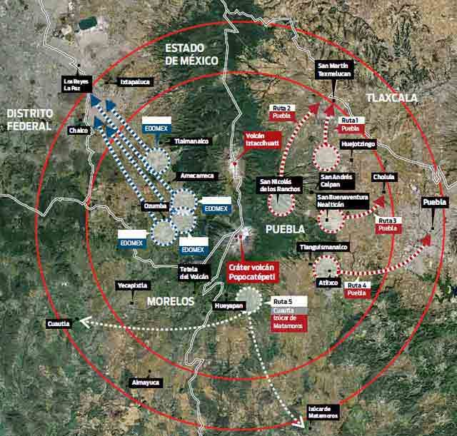
Evacuation plans have been in place since 1994, and they have been modified and updated regularly since. There are ten major evacuation routes (see map). The villages most at risk (inside the 12-kilometer radius “high risk” zone) include several in the states of Puebla (San Nicolás de los Ranchos, Santiago Xalitzintla, San Pedro Benito Juárez, San Baltazar Atlimeyaya and Tochimilco), Morelos (Ocuituco, Tetela del Volcán, Yecapixtla, Zacualpan de Amilpas and Temoac) and the State of México (Tepetlixpa, Ozumba, Atlautla, Ecatzingo and Amecameca).
Last week, the evacuation system (that will only be put into effect if the risk level rises) was tested with a large-scale practice evacuation in which the Mexican Army assisted municipal and state officials and emergency response crews. The practice has enabled authorities to improve the forecasts of precisely how long it will take to evacuate all villagers from the likely danger zone, in the event that the risk level is raised.
Evacuation will not be easy. Some local inhabitants argue that the volcano has never caused them any harm, because, on the contrary, it is their “protector and guide”. They are unlikely to move voluntarily even if an eruption is imminent. They hold a festival each year on 12 March thanking the volcano for its rich soil, abundant rainfall and “to keep the volcano calm and happy.” The ceremonies include the placing of offerings part-way up the volcano, accompanied by folk dancing.
Related posts:


Sorry, the comment form is closed at this time.