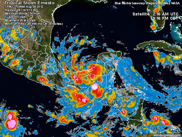
Hurricane Ernesto was the fifth Atlantic Ocean storm of this hurricane season. It struck the Quintana Roo coast on the night of August 7/8, as a Category 1 hurricane packing winds of up to 165 kph (103 mph), and then weakened to a Tropical Storm as it moved across the Yucatán Peninsula, along the Gulf coast of Campeche and Veracruz (August 8). It turned inland near Coatzacoalcos (Veracruz) with winds of 96 kph (60 mph), before continuing to weaken as it headed westwards over Oaxaca, across the Isthmus of Tehuantepec (August 9).
Ernesto brought violent winds and torrential rain to many parts of southern Mexico, impacting at least nine states: Quintana Roo, Yucatán, Campeche, Chiapas, Tabasco, Veracruz, Oaxaca, Puebla, Guerrero. Twelve deaths have been reported resulting from flooding, the collapse of trees and billboards, and lightning strikes. Federal authorities estimate that at least 19,000 homes were damaged by the storm.
In Quintana Roo, prior to the arrival of Ernesto, authorities ordered the evacuation of tourists from resorts in Mahuahal and southern Quintana Roo to the city of Chetumal. Two cruise ships due to visit the Riviera Maya delayed their arrival. The villagers of Punta Allen were taken to emergency shelters as a precaution.
On the Gulf coast, several major oil ports, including Coatzacoalcos, Cayos Arcas and Dos Bocas, were temporarily shut down.
Throughout the region affected by Ernesto, power lines, trees, utility posts and advertising billboards were downed. Many areas were flooded, especially low-lying and “irregular” settlements, those lacking formal planning and infrastructure. Dozens of landslides occurred, and road crews had to clear mud, trees and debris that had temporarily cut many highways.
The worst affected area seems to be Veracruz, which reported 9 deaths from the storm. A federal state of emergency has been declared in 58 municipalities in Veracruz, which allows authorities to access funds from the National Fund for Natural Disasters (Fonden) for the food, shelter and health needs of the population affected.
These municipalities include: Álamo Temapache, Benito Juárez, Castillo de Teayo, Cazones de Herrera, Chicontepec, Chumatlán, Coahuitlán, Coatzintla, Coxquihui, Coyutla, Espinal, Filomeno Mata, Gutiérrez Zamora, Huayacocotla, Ilamatlán, Ixhuatlán de Madero, Mecatlán, Papantla, Platón Sánchez, Poza Rica, San Rafael, Tantoyuca, Tecolutla, Tempoal, Texcatepec, Tihuatlán, Tlachichilco, Tuxpan, Zacualpan, Zontecomatlán, Zozocolco de Hidalgo.
It is likely to be some time before things get back to normal in these areas since more heavy rains are expected in the next few days.
Related posts:
- Hurricane names and forecast for 2012
- In which months are hurricanes most likely to strike Mexico?
- Mexican geophysicists develop new model for hurricane forecasting

Sorry, the comment form is closed at this time.