Ajijic | Geo-Mexico, the geography of Mexico

Cultural change in a Mexican village: the case of Ajijic on Lake Chapala

 Books and resources  Comments Off on Cultural change in a Mexican village: the case of Ajijic on Lake Chapala
Mar 152023
 

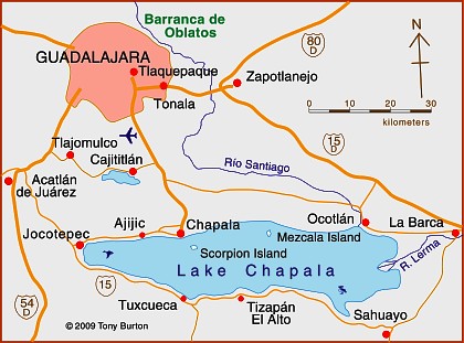
Numerous academic studies have looked at different aspects of the long-established Ajijic retirement community at Lake Chapala. The earliest studies, in the 1970s, looked almost exclusively at the characteristics of the incoming migrants.

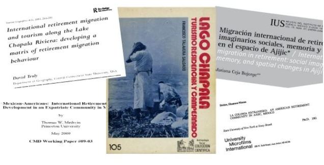
Mexican sociologist Francisco Talavera Salgado in Lago Chapala, turismo residencial y campesinado, focused exclusively on the varied impacts of foreign residents on the local Ajijic community.

academic-coversAnthropologist Eleanore Moran Stokes homed in on Ajijic and suggested that the evolution of the village after ‘Discovery’ could be divided into three distinct phases: Founder (1940s to mid 1950s), Expansionary (mid 1950s to mid 1970s) and Established Colony (mid 1970s through the 1980s). During the Founder phase, Ajijic served, in her view, largely as an artists’ colony, whereas later (Expansionary phase) arrivals tended to be members of the affluent and retired middle class; these newer arrivals began to materially change the village by infusing cash into the local economy and starting businesses. They upgraded village homes and created “a new wage labor class in the village.”

In the Established Colony phase vacant houses became increasingly scarce, agricultural land was parceled for vacation and retirement homes, and philanthropic activities became important. Stokes estimated that, by 1979, foreigners occupied about 300 of the 950 houses in the village, but comprised less than 8% of the population.

Geographer David Truly built on Stokes’ framework to develop a matrix of retirement migration behavior. Like Stokes, Truly concluded in 2002 that newer visitors (including retirees), and unlike earlier migrants, had less desire to adapt to the local culture and were more keen on ‘importing a lifestyle’ to the area.

Sociologist Stephen Banks, studied the identity narratives of retirees while he was living in Ajijic in 2002-2003. He concluded that the responses he received during dozens of in-depth interviews revealed:

a struggle to conserve cultural identities in the face of a resistant host culture that has been colonized…. The Lakeside economy is dominated by expatriate consumer demand; indigenous commerce in fishing has disappeared as new employment opportunities opened up in the services sector; local prices for real estate (routinely listed in US dollars), restaurant dining, hotel lodging and most consumer goods are higher than in comparable non-retirement areas; traditional Mexican community life centered around the family has been supplemented, and in some cases supplanted, by expatriate community life centered around public assistance and volunteer programs… and the uniform use of Spanish in public life is displaced by the use of English.”

Some more recent work has focused on the changes in the host community. For example, Marisa Raditsch investigated the impacts of international migrants “based on the perceptions of Mexican people in the receiving context.” Her 2015 study found that these perceptions tended “to be favorable in terms of generating employment and contributing to the community; and unfavorable in terms of rising costs of living and some changes in local culture.”

Even more recently, Mexican researcher Mariana Ceja Bojorge focused squarely on the relationships and interactions between local Ajijitecos and foreigners. She concluded in 2021 that the shift “endangers the acceptance of the presence of the other” and that “Although the presence of foreigners has generated economic well-being in the area, it has also been responsible for the reconfiguration of space, where locals have been forced to leave their territory.”

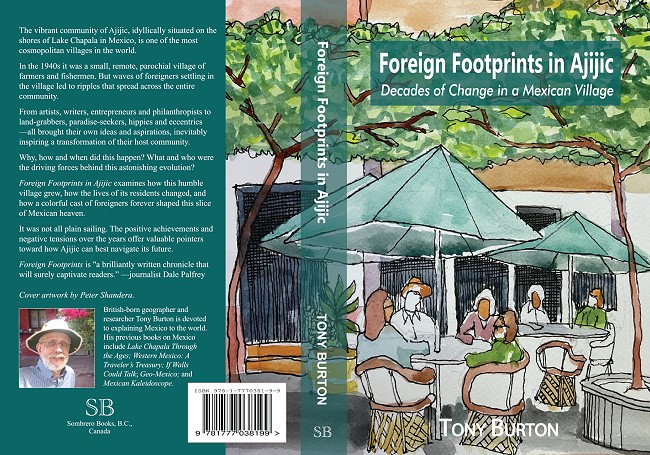
The details of the extraordinary changes that have taken place in Ajijic since the 1930s are the subject of my 2022 book, Foreign Footprints in Ajijic: Decades of Change in a Mexican Village.

This cover of the book shows a popular restaurant on Ajijic plaza, a perfect example of these changes or reconfiguration of space. The plaza was originally a Mexican space, where locals filled water containers, met friends, gossiped, socialized and bargained at the weekly market. The chapel and all the stores around the plaza were exclusively run by village residents to meet local needs. In those years, if there was a center for foreigners it was the Posada Ajijic bar, restaurant and gardens.

The use of the plaza has changed. After Cine Ajijic opened on the north side of the plaza in 1969, its weekly English-language films actively encouraged foreigners (en masse) to share the same social space as the local community. The supermarket on the south side of the plaza also became a shared space for locals and foreigners, a dual role which continued after the premises became a bank. Stores and restaurants either owned by, or designed to serve, foreigners were established around the plaza. An even stronger foreign focus is evident in the plaza coffee shops which spill over onto what was formerly public space. This has inevitably resulted in a debate about the appropriateness of a private enterprise occupying public space, and whether even paid use, via concessions, is an acceptable tradeoff for the loss of such space. Compromise is needed by all; there will never be any one-size-fits-all solution to any of the issues arising from migration and cultural change.

Full bibliographic details of all the studies mentioned above are included in the bibliography of Foreign Footprints in Ajijic: Decades of Change in a Mexican Village

Geo-Mexico is reader-supported. Purchases made via links on our site may, at no cost to you, earn us an affiliate commission. Learn more.

Retirees and “residential tourism”: a case study of Chapala-Ajijic in Jalisco

 Excerpts from Geo-Mexico  Comments Off on Retirees and “residential tourism”: a case study of Chapala-Ajijic in Jalisco
Jan 162014
 

Retirees, mainly from the USA and Canada, form a special subgroup of tourists. About 1 million US visitors to Mexico each year are over the age of 60. Their total expenditure is about $500 million a year. Three-quarters arrive by air; half of these stay 4-8 days and almost one in ten stays 30 days or longer. Half stay in hotels, and one-third in time-shares; the remainder either stay with family or friends, or own their own second home. Of the 25% arriving by land, almost one in three stays 30 days or more. For Canadians, the patterns are broadly similar except that a higher percentage arrive by air.

The number of retiree tourists is relatively easy to quantify. However, it is extremely difficult to place accurate figures on the number of non-working, non-Mexicans who have chosen to relocate full-time to Mexico. Technically, these “residential tourists” are not really tourists at all but longer-term migrants holding residency visas. They form a very distinct group in several Mexican towns and cities, with lifestyle needs and spending patterns that are very different from those of tourists. Their additional economic impact is believed to exceed $500 million a year.

Map of Lake Chapala, Jalisco, Mexico

Map of Lake Chapala, Jalisco, Mexico. Credit: Tony Burton; all rights reserved.

The largest single US retirement community outside the USA is the Guadalajara-Chapala region in Jalisco, according to state officials (see map). The metropolitan area of Guadalajara, Mexico’s second city, has a population of about 4 million. The villages of Chapala and Ajijic (combined population about 40,000) sit on the north shore of Lake Chapala some 50 km (30 mi) to the south. Historically, Chapala was the first lakeshore settlement to attract foreign settlers, as early as the start of the 20th century. Today the area is home to a mix of foreign artists, intellectuals, escapees (of various non-judicial kinds), pensioners and ex-servicemen. In the last 40 years, Ajijic has become the focal point of the sizable non-Mexican community living on the lakeshore. Depending on how they are defined, there are probably between 6000 and 10,000 foreign residents in the Chapala-Ajijic area, the higher number reflecting the peak winter season. About 60% of retirees in the area own their own homes or condos, though many still own property in the USA or Canada as well, and many make regular trips north of the border.

The main pull factors for residential tourists are an amenable climate; reasonable property prices; access to stores, restaurants and high quality medical service; an attractive natural environment; a diversity of social activities; proximity to airports; tax advantages, and relatively inexpensive living costs.

David Truly has suggested that conventional tourist typologies do not work well with Ajijic retirees. He identified migrant clusters with similar likes and dislikes. Retirees vary in education, travel experience and how they make decisions about relocation. Early migrants tended to dislike the USA and Canada and adapted to life in Mexico. They were generally content with anonymity unlike many more recent migrants. Traditional migrants appreciate all three countries, but have chosen Mexico as their place of permanent residence. Many new migrants do not especially like the USA or Canada but are not particularly interested in Mexico either. They seek familiar pastimes and social settings and are content to have relatively little interaction with Mexicans.

The large influx of residential tourists into small lakeside communities like Ajijic inevitably generates a range of reactions among the local populace. From empirical studies of regular tourism elsewhere, George Doxey developed an “irritation index” describing how the attitudes of host communities change as tourist numbers increase. His model applies equally well to residential tourists. In the initial stage the host community experiences euphoria (all visitors are welcome, no special planning occurs). As numbers increase, host attitudes change to apathy (visitors are taken for granted) and then annoyance (misgivings about tourism are expressed, carrying capacities are exceeded, additional infrastructure is planned). If numbers continue to grow, hosts may reach the stage of antagonism, where irritations are openly expressed and incomers are perceived as the cause of significant problems.

Residential tourism in the Chapala-Ajijic area has certainly wrought great changes on the landscape. Residential tourists have created a distinct cultural landscape in terms of architectural styles, street architecture and the functions of settlements. (Browse the Chapala Multiple Listing Service New Properties). Gated communities have been tacked on to the original villages. Subdivisions, two around golf courses, have sprawled up the hillsides. Swimming pools are common. Much of the signage is in English. Even the central plazas have been remodeled to reflect foreign tastes. Traditional village homes have been gentrified, some in an alien “New Mexico” style.

On the plus side, many retirees, as a substitute for the family they left behind, engage in philanthropic activities, with a particular focus on children and the elderly. Retiree expenditures also boost the local economy. Areas benefiting from retirees include medical, legal and personal services, real estate, supermarkets, restaurants, gardening and housecleaning. Employment is boosted, both directly and indirectly, which improves average local living standards.

On the minus side, decades of land speculation have had a dramatic impact on local society. Land and property prices have risen dramatically. Many local people have become landless domestic servants, gardeners and shop-keepers with a sense that the area is no longer theirs. Crime levels have risen and some local traditions have suffered. The abuse of water supplies has resulted in declining well levels. Over zealous applications of fertilizers and pesticides have contaminated local water sources.

Other locations besides Chapala-Ajijic where a similar influence of non-Mexican retirees on the landscape can be observed include San Miguel de Allende (Guanajuato), Cuernavaca (Morelos), Mazatlán (Sinaloa), Puerto Peñasco (Sonara), Rosarito (Baja California) and Todos Santos (Baja California Sur). The most preferred locations are all on the Pacific coast side of Mexico.

As more baby-boomers reach retirement age, residential tourism offers many Mexican towns and cities a way of overcoming the seasonality of conventional tourism. Lesser-developed regions have an opportunity to cash in on their cultural and natural heritage and improve their basic infrastructure.

This is a lightly edited excerpt from chapter 19 of Geo-Mexico: the geography and dynamics of modern Mexico.

References:

  • Boehm S., B. 2001 El Lago de Chapala: su Ribera Norte. Un ensayo de lectura del paisaje cultural. 2001. Relaciones 85, Invierno, 2001. Vol XXII: 58-83.
  • Burton, T. 2008 Lake Chapala Through the Ages, an Anthology of Travellers’ Tales. Canada: Sombrero Books.
  • Doxey G.V. 1975 A causation theory of visitor‑resident irritants: methodology and research inferences. Proceedings of the Travel Research Association, San Diego, California, USA: 195‑8.
  • Stokes, E.M. 1981 La Colonia Extranero: An American retirement Community in Ajijic, Mexico. PhD dissertation, University of New York, Stony Brook, cited in Truly, D. 2002.
  • Truly, D. 2002 International Retirement migration and tourism along the Lake Chapala Riviera: developing a matrix of retirement migration behavior. Tourism Geographies. Vol 4 # 3, 2002: 261-281.
  • Truly, D. 2006 The Lake Chapala Riviera: The evolution of a not so American foreign community, in Bloom, N.D. (ed) 2006 Adventures into Mexico: American Tourism beyond the Border. Rowman & Littlefield: 167-190

Related posts:

Canadian Club of Ajijic listens to Geo-Mexico co-author

 Other  Comments Off on Canadian Club of Ajijic listens to Geo-Mexico co-author
Jan 152010
 

More than 300 people packed the grounds of La Nueva Posada hotel in Ajijic, Mexico, to hear Geo-Mexico co-author Tony Burton talk about the significance of 2010 in Mexico. Burton took an historical approach, exploring both the history of geography and the geography of history while comparing many aspects of Mexico in 1810 (Independence), 1910 (Revolution) and 2010. His entertaining and informative talk, which was largely based on material in Geo-Mexico, was well received.
At the end of his talk, Burton highlighted the fact that Mexico’s population projections for 2050 suggest that the country will have moved from a predominately young to an elderly population in only one or two generations.

Tourism index page

 Index page  Comments Off on Tourism index page
May 232017
 

This Tourism index page lists the most relevant posts on Geo-Mexico related to tourism, including history of tourism in Mexico, types of tourism, major resorts, and current trends. It is updated periodically.

Importance of tourism:

History of tourism in Mexico, hotels, publicity campaigns:

Magic Towns:

Cancún and the Riviera Maya (Maya Riviera), Quintana Roo:

Huatulco and Oaxaca:

Acapulco:

Geotourism and ecotourism in Mexico:

Cruise ships:

Lake Chapala, Ajijic, Chapala and the Lerma-Chapala basin:

Megaproject proposals and conflicts over tourism:

Specialized forms of tourism (tourism niche markets):

Other (miscellaneous):

Other Geo-Mexico index pages:

Easter celebrations in Mexico

 Other  Comments Off on Easter celebrations in Mexico
Apr 102017
 

Mexicans celebrate Easter in considerable style with processions and re-enactments of religious events. The MexConnect Easter Index page has a varied collection of articles and photo galleries relating to the Easter period in Mexico.

Easter procession in San Miguel de Allende. Photo: Don Fyfe-Wilson. All rights reserved.

Easter celebrations have been held for centuries in many of Mexico’s towns and cities, though the details may have changed over the years. This MexConnect article, for example, features photos from a Good Friday procession held in San Miguel de Allende in the mid 1960s.

The festivities in dozens of villages and towns throughout the country, including Tzintzuntzan in Michoacán and San Cristóbal de las Casas in Chiapas, have a very long history.

In other villages, the present-day, large-scale Easter celebrations are not genuinely “traditional” but are a relatively new introduction to the local culture. This is true, for instance, in the case of the Easter activities in Ajijic, on the northern shore of Lake Chapala, where, “The local townspeople take honor in portraying the cast mentioned in the Bible. Mary, the mother of Jesus, Mary Magdalene and the other Mary are there, along with wonderfully costumed early Christians and complacent Roman townspeople and authority figures.”

Perhaps the single most famous location in Mexico for witnessing Easter events is Iztapalapa near Mexico City. See here for photos of the 2013 Celebration of Easter Week in Iztapalapa.

Note: This post was originally published in April 2010, updated in April 2014 and republished in 2017.

The geography of Mexico’s religions is analyzed in chapter 11 of Geo-Mexico: the geography and dynamics of modern Mexico; many other aspects of Mexico’s culture are discussed in chapter 13.

Related posts:

Novelist Charles Fleming Embree, an honorary geographer

 Other  Comments Off on Novelist Charles Fleming Embree, an honorary geographer
May 302016
 

American author Charles Fleming Embree‘s A dream of a throne, the story of a Mexican revolt, published in 1900, is, I believe, the earliest novel in any language about the Lake Chapala area. It is an historical novel, set in the area during the nineteenth century, but Embree reveals an extraordinary depth of knowledge, not only of the history of this area, but also of its geography.

Embree was only 24 years of age when he and his wife Virginia, newly-weds at the time, arrived in Chapala in 1898. Embree had dropped out of Wabash College in his native Indiana, without completing his degree, to devote himself to his writing and his first book, a collections of stories entitled For the Love of Tonita, and other tales of the Mesas (1897) had proved successful.

The Embrees lived in Chapala for eight months in 1898, before traveling to other parts of Mexico, including Guanajauto, Xalapa, Cuernavaca and Oaxaca. Embree’s publishers described A dream of a throne as, “A powerful and highly dramatic romance, dealing with a popular Mexican uprising half a century ago. It is a novel of adventure and of war, and its strongly contrasted characters glow with life and realism. The writer’s thorough knowledge of Mexican life gives him a wealth of new material; and the descriptions of scenery at Lake Chapala are vivid, full of color, and alive with mountain air”.

A Dream of a Throne by Charles F. Embree

A Dream of a Throne by Charles F. Embree

The book is indeed a remarkable achievement. Despite only living at Lake Chapala for a few months, Embree acquired and demonstrates, from a geographical perspective, an extraordinarily accurate and astute knowledge of all his lakeside locales. The spelling of all place-names, with the exception of Ajicjic and Tuxcueco, is exactly as it is today. Details of clothing, habits and customs all ring true. Embree’s knowledge of the region’s nineteenth century history is equally impressive. As one small example, the story begins in the shadow of St. Michael’s hill in Chapala in May 1833, amidst fear of an epidemic of smallpox. In real life, the nearby city of Guadalajara suffered a cholera epidemic in the summer of 1833.

From a human geography perspective, this novel offers us one of the earliest descriptions of everyday indigenous life in the region. As Dr. Wolfgang Vogt of the University of Guadalajara has pointed out, even by the 1920s (twenty years after Embree’s novel), virtually no-one was observing or writing about this area from an indigenous point of view. Embree’s novel has particular value since it examines the conflicts between Indians and Spaniards, anticipating the themes explored by D. H. Lawrence when he visited Chapala for a couple of months in 1923 and penned the first draft of The Plumed Serpent.

All the action in Embree’s novel takes place on and around Lake Chapala. The major locales are Mezcala Island, Chapala, Ajijic and Tizapan. The following extracts have been chosen to highlight his depictions of the local landscapes. Lake Chapala was significantly larger in 1898 than it is today (see The eastern end of Mexico’s largest lake, Lake Chapala, is amputated):

Lake Chapala, showing area drained at start of 20th century. Map: Tony Burton. All rights reserved.

Lake Chapala, showing area drained at start of 20th century. Map: Tony Burton. All rights reserved.

Here is Embree’s description of Ajijic:

They were riding over a rough trail with cacti and stones about, and here and there a flock of goats. To the right was a seemingly endless chain of mountains, to the left, more distant, rose St. Michael, low and round (behind whose bulk lay Chapala and the water), and the larger head, called Angostura, lying between that town and Ajicjic on the lake’s edge. Between Angostura and the opposite mountain chain the road led, rising to a hill, to whose summit the little army came. They looked down on the lake and, nearer, small irregular fields, scores of them, checkering a level stretch from mountains to water. Out of these, Ajicjic’s church thrust up a single gleaming tower of white. Three o’clock found the troop sweeping into the barren plaza of that fishing village.

To this day Ajicjic can claim no more than some two thousand souls. It has, even yet, no railroad, no stage; rarely has a vehicle been seen in that primitive place other than the awkward oxcart. Its low, unplastered adobe walls stand close together. The streets are alleys of extreme narrowness wherein there is mud when it rains, dust when it is dry, rocks and swine forever. Nigh every alley twists and turns, is for a block no more than a gutter, for another block a public stable for burros. Yet one may find some better quarters. The plaza, though it is only a bare, brown waste, is wide. The open court before the church, though it too is bare and dirty, with lonely, crumbling walls and pillars about it, yet has in its center a weather-beaten cross that speaks of service to the Lord.

The troop filled the plaza. It was halted, and the inhabitants of the town, struck with amazement, either shut themselves up or gathered in silence round about. Groups of brown children, absolutely naked, sat down in the dirt, thumbs in mouth, to wonder in comfort. Rodrigo and Bonavidas began the inquiries, prefacing them with jocularly expressed friendship to certain storekeepers and a toss of tequila here and there down a willing throat. Boats? There hadn’t come but one boat to Ajicjic the blessed day. Ajicjic was losing importance in these times. On market days everybody went to the bigger market at Chapala, where the news was dispersed. And this one boat? It had come from Tizapan with a load of wood for the lime burners.

His landscape descriptions are equally adept:

The town of Tizapan lies at a short distance from the lake. The shore in that region is no such distinctly marked line of beach and rock as it is at Chapala. It is not even always easy to tell where the shore is. Between water and land there is a stretch of marsh for several hundred yards, watery, pierced by the spears of a million reeds that rise thick and green to a height of some feet. Here flock ducks in great numbers. The marsh is flat, bewildering, and dreary. Through its middle a stream, called the Tizapan River, cuts out more than one course, having formed a delta. The main course of this river, not over twenty yards at its widest part, usually much narrower, is navigable for canoas for half a mile to a point where the land is dry and from which the town lies yet another mile distant. The stream being crooked and the curves sharp, the progress from the open lake to the inner landing is usually made by poles. The lake approach to the town could be easily blocked by blocking the river. Only the one course is navigable. Nobody could cross the marshes. This fact was recognized more than a century ago.

The town itself is like the greater part of Mexican towns, narrow and crooked streets with the low houses (joined together) shutting those streets in and making them seem even narrower, and the central plaza of considerable size left vacant. That plaza is today filled with flowers and fruit and contains a bandstand. In former times it was bare. The mountains rise only a little way behind the town, jagged and huge. Before them is a stretch of rolling green fields. The river, coming from the peaks, dashes down through this pastoral scene with a vivacity that has laid bare a rough and rocky bed whereon the water boils till it passes through the town. At the time when the two small armies were approaching Tizapan, much of the summer green was still on field and mountain. The unclouded sun poured his light over an emerald gem of the lake’s border.

After their time in Mexico, the Embrees settled in Santa Ana, California. Embree published his second novel A Heart of Flame: the Story of a Master Passion in 1901, and supplied a steady stream of short stories to major magazines, including McClure’s, the San Francisco Argonaut and Sunset Magazine. Sadly, the couple had not long celebrated the birth of their only daughter Elinor in 1905 when Embree was taken seriously ill. He died on July 3, not yet 31 years old.

It is tragic that someone who had produced work of this magnitude, should have died so terribly young. In his short time in Chapala, Charles Embree had acquired an excellent historical and geographical knowledge of the region at a time when American travelers to the lake were few and far between. Geo-Mexico believes that Charles Fleming Embree fully deserves to be declared an Honorary Geographer.

Note: The post is based on chapter 43 of Lake Chapala through the ages; an anthology of travellers’ tales (Sombrero Books, 2008) and on American novelist Charles Fleming Embree set his first novel at Lake Chapala” (MexConnect, 2009).

Related posts:


Apr 282016
 

Like most geographers, I collect maps and information wherever I travel; you never know what surprises await. Tourism publications are especially interesting since they are specifically designed (one assumes) to show the best side of the places described.

My collection of tourist brochures associated with Jalisco and the Lake Chapala area dates back more than thirty years. Many early versions had stylized maps, drawn by graphic designers, not cartographers, with sound (if uninspiring) text in Spanish. English translations were often unintelligible. In the 1980s, several bilingual members of the now-defunct Association of Travel Reporters, based in Guadalajara, offered to help the Jalisco State Tourism Department improve its translations, but the offer was politely declined.

chapala-brochure-2016

As this latest brochure relating to Lake Chapala shows, translation standards have not improved significantly since then, and remain a long way off “native speaker” level. This is particularly unfortunate, given that this area of Mexico has the largest concentration of English-speakers in the country.

Here, for example, is the English translation of the attractions of San Juan Cosalá:

One has to closely experience San Juan Cosalá in order to feel and enjoy it to the most, so come and discover a place you will never want to leave, for every happy moment can be lived here, as just by visiting you feel enveloped in an affluent of joy and vitality.

In getting to know it, just stroll across its Pier, or admire the harmonious architecture in San Juan Evangelista Church, or enjoy the exquisite aromas of seafood, bouncing from restaurants enlivened with fine music while walking over the Piedra Barrenada (Drilled Stone); or the rest;  freshness and fun offered in thermal waterparks and world level spas.

Undated tourism brochure, collected April 2016

Undated tourism brochure, collected April 2016

The cartography (above) also leaves a lot to be desired. A key (not shown in this post) is provided but the Jalisco Tourism department clearly needs to hire a geographer if they want to publish useful and meaningful maps. Details worth noting include:

  • No symbol in the key for the “gas station” signs shown on the map. The map shows only four gas stations in this area (and none in Chapala or Ajijic); there are dozens of others not shown on the map, including several in Chapala and Ajijic.
  • The map has no scale.
  • The Isla de los Alacranes, a short boat-ride from Chapala, is shown a long way south of its true position, and a lot further from Chapala than it really is.
  • The dark blue area is, according to the key, the Chapala Lakeshore. I have absolutely no idea what it really represents! Lake Chapala’s catchment area is a completely different shape to the dark blue area. The “Chapala Lakeshore” should, obviously, also include the south-east section of the lake around Las Palmas and Cojumatlán. Much of the area colored dark blue is out of view of the lake, and drains towards the Santiago River, not the lake.
  • Placing the word “CHAPALA” in the north-east section of the dark blue area is totally misleading. The area where the word is written is NOT in the lake basin, not in view of the lake, and is not even in the municipality of Chapala. Again, I have no idea why the artist responsible for this map chose to ignore geography.

It is 2016, and Jalisco State tourism officials still need to improve the quality of their brochures and maps. Come on guys! Time to up your game!

Nov 072015
 

A BBVA-Bancomer report, based on Mexico’s 2010 census data includes an interesting graph showing where “Americans older than 50” live in Mexico. The data is based on place of birth, so some of the “Americans” in the data are of Mexican heritage – they were born in the USA, to parents who were born in Mexico, and have since relocated to Mexico.

americans-in-mexico-2010-graph

As the graph highlights, almost half of all Americans living in Mexico live in one of just 20 municipalities. Tijuana, just across the border from San Diego, leads the way, with 6.4% of all the Americans over age 50 living in Mexico, followed by Chapala and San Miguel de Allende, the only two non-border municipalities in the top seven locations for older Americans.

Perhaps no surprise, then, that both these areas have weekly English-language newspapers. The Chapala area is served by The Guadalajara Reporter which covers Guadalajara, Zapopan, Chapala and (to a lesser extent) Puerto Vallarta, potentially reaching 9.7% of all Americans over the age of 50 in Mexico. For its part, San Miguel de Allende has Atención San Miguel. Both locations are popular choices for retirement.

Kudos to “Madeline”, who points out in a comment (below), that there are several other English-language papers in Mexico. They include two in Puerto Vallarta: PV Mirror and the Vallarta Tribune. In Quintana Roo, Playa del Carmen has the Playa Times. In Baja California, there is the biweekly Baja Times and no doubt there are a few others, which we will add in due course! [Based in Mexico City, The News – thenews.mx – was the closest thing to a national daily in English, with distribution points in many parts of the country, but ceased publication in early 2016.]

Related posts:

Will UNESCO give World Heritage status to Lake Chapala?

 Books and resources, Other  Comments Off on Will UNESCO give World Heritage status to Lake Chapala?
Sep 072015
 

We don’t often champion causes in these pages, but are more than willing to lend our support to a campaign hoping to persuade UNESCO to declare Lake Chapala a “World Heritage” site. The campaign appears to have stalled, and deserves more support.

The following 6-minute video (English subtitles) from 2008 sets the scene for those unfamiliar with the area:

Where is Lake Chapala?

Map of Lake Chapala

Map of Lake Chapala. Credit: Tony Burton; all rights reserved.

Why should Lake Chapala be declared a World Heritage site?

Natural history: it is Mexico’s largest natural lake and home to some unique endemic fauna.

Cultural and historic significance: it is a sacred site for the indigenous Huichol Indian people. Specifically, the southernmost “cardinal point” in their cosmology is XapaWiyemeta, which is Scorpion Island (Isla de los Alacranes) in Lake Chapala.

In the nineteenth century, as Mexico fought for its independence from Spain, Lake Chapala was the scene of a truly heroic struggle, centered on Mezcala Island, between the Royalist forces and a determined group of insurgents. It proved to be a landmark event, since after four years of fighting, an honorable truce was agreed.

At the very end of the nineteenth century, influential families from Mexico and from overseas “discovered” Lake Chapala. For several years, Mexico’s then president, Porfirio Díaz, made annual trips to vacation at the lake. As the twentieth century progressed, the area attracted increasing numbers of authors, poets and artists, many of them from abroad, including such greats as D.H. Lawrence, Tennessee Williams, Witter Bynner, Charles Pollock and Sylvia Fein. (To discover more of the literary and artistic characters associated with Lake Chapala, please see this on-going series of mini-biographies.)

Today, it is the single largest retirement community of Americans anywhere outside of the USA.

Is this enough to qualify Lake Chapala for World Heritage status? I don’t know, but it certainly seems worth a shot!

Posts related to Lake Chapala:

Tourism in the Lake Chapala (Ajijic, Chapala, Jocotepec) and the Lerma-Chapala basin:

Want to read more?

For general introduction and background to this area, see the first eight chapters of my Western Mexico: A Traveler’s Treasury (4th ed, 2013). In the words of Dale Palfrey, reviewing the book for the Guadalajara Reporter, “First published in 1993, the revised and expanded fourth edition of “Western Mexico”… opens with what qualifies as the most comprehensive guide to the Lake Chapala region available in English.“

For a more in-depth account of the history of the Lake Chapala region up to 1910, see my Lake Chapala Through the Ages, an anthology of travelers’ tales. It features informative extracts from more than fifty original sources, linked by explanatory text and comments, together with brief biographies of the writers of each extract. They include some truly fascinating characters… see for yourself!

Both books are available as regular print books, or in Kindle and Kobo editions.

Mexico hosts 2014 World Tourism Day

 Books and resources, Mexico's geography in the Press  Comments Off on Mexico hosts 2014 World Tourism Day
Sep 272014
 

Today Mexico is hosting World Tourism Day, so this seems like a good time to review the state of Mexico’s tourism sector. The official celebrations are being held in the city of Guadalajara.

The decision by The World Tourism Organization that Mexico should host the 2014 World Tourism Day recognizes Mexico’s importance in world tourism. Mexico is the 13th most popular international destination in the world. In 2013, it welcomed 23.7 million international tourists, who spent 13.8 billion dollars in the country. World Tourism Day 2014 highlights tourism’s social, cultural, political and economic benefits, and its importance in community development.

Earlier this year, Mexico’s Tourism Secretariat published a detailed analysis of the Tourism Industry in Mexico in 2013.

The text of the magazine format publication (link above) is in Spanish, but it includes lots of graphs and maps showing tourism’s trends and patterns. The 21 pages of information cover topics from the origin and spending of tourists to cruise ship ports, hotel occupancy, and number of international flights. The publication offers a wide variety of data and an ideal basis for students who want to design and produce infographics about tourism.

And how is tourism doing in 2014?

So far, all the signs are positive. The number of international visitors for the first half of the year was up 19.6% to 14.2 million, compared to the 11.9 million recorded for the first six months of 2013. Spending in the first half of the year was up 17.6% to 8.435 billion dollars.

Related posts:

How can tourism perception be assessed? A case study using the Lerma-Chapala drainage basin

 Books and resources, Teaching ideas  Comments Off on How can tourism perception be assessed? A case study using the Lerma-Chapala drainage basin
Aug 282014
 

In numerous previous posts, we have looked at the importance of tourism in Mexico, and have examined its impacts at different scales, from the national/international scale at one extreme to the single resort scale at the other:

National scale:

Sub-national regional scale:

Single resort scale

We have also considered the way in which the characteristics of tourism in a resort change over time:

Attempting to quantify the importance or impacts of tourism, beneficial or otherwise, is fraught with methodological difficulties. The number of hotel rooms in different cities is often used as a proxy measure of the relative importance of tourism in different communities, but looking only at tourist capacity “masks  the fact that hotels are rarely full. In 2007, the national occupancy rate was 54.8%. Traditional beach resorts such as Acapulco, Mazatlán and Puerto Vallarta had an occupancy rate of 52.2%, compared to 68.1% for modern, planned mega-resorts like Cancún and Los Cabos. The occupancy rate in the large cities—Guadalajara, Mexico City and Monterrey—was 55.0%, well ahead of the 47.2% for other interior cities.” (Geo-Mexico, p 134).

As in other branches of geography, it is not only the “reality” that matters, but also people’s perceptions of reality. Most decisions concerning location (such as where to live, the best place to start a new business. etc) are taken on imperfect or incomplete information; in other words, these decisions are based, at least to some extent, on perceptions.

In the case of tourism, it is the perception of visitors that matters. This is precisely why certain resorts gain a reputation as being “jet set” or the “in place” to vacation. The “in place” today is not going to be the “in place” in a few year’s time, since perceptions (and reality) change. Nowhere has this proved to be more true in Mexico than in the case of Acapulco.

But is it possible to measure tourist perceptions? It is very difficult to do so directly, but there are ways of tackling this question, and here we look at one approach, based on an analysis of tourist-oriented literature.

The approach is easiest to explain in the context of a real example, in this case an analysis of the likely perception of foreign tourists of destinations in the Lerma-Chapala drainage basin in Mexico. (This study formed part of my contribution on tourism to the Atlas de la cuenca Lerma-Chapala, construyendo una visión conjunta, Semarnat-Unam-IE, 2006 – the link is to a low-resolution pdf of the entire atlas).

The Lerma-Chapala Basin (see map) is one of Mexico’s major river systems, comprising portions of 127 municipalities in five states: México, Querétaro, Michoacán, Guanajuato and Jalisco. The basin has considerable economic importance. It occupies only 2.9% of Mexico’s total landmass, but is home to 9.3% of Mexico’s total population, and its economic activities account for 11.5% of national GDP. It also has considerable importance for tourism.

Lerma Basin Tourist Perception Index.

Lerma Basin Tourist Perception Index. Cartography: Tony Burton / Geo-Mexico; all rights reserved Click to enlarge.

The red circles superimposed on the map represent an index of tourism perception. This index is based on an analysis of seven tourist guides that purport to cover the entire country:

  • AAA Tourbook (2004)
  • Let’s Go Mexico (2004)
  • Lonely Planet (2002)
  • Footprint Guide (1999)
  • Upclose Mexico (1998)
  • Insight Guide (1994)
  • Cadogan Guide (1991)

In each case, the total number of lines of text in the guide devoted to any location within the Lerma-Chapala drainage basin was counted, as well as the number of lines devoted to each individual location. This allowed a ratio or percentage to be worked out for each place for each book. For example, if a book had 240 lines in total devoted to the drainage basin, of which 60 were devoted to San Miguel de Allende, the perception index for San Miguel for that book would be 60/240 * 100 = 25%. Similar calculations were performed for all the locations mentioned, for each book, and then the mean index was calculated for each location. These mean indices were the basis for the size of the circles on the map.

In broad terms, the map shows which places are likely to be on a foreign traveler’s radar when they are visiting the area. Those familiar with this area may be surprised to see that the ghost town of Pozos merits as many lines of text as Quiroga (and indeed more lines of text than Atotonilco). Another surprise is that Tzintzuntzan appears to be as much in the tourist eye as Chapala, Dolores Hidalgo or Toluca. The main purpose of this post is not to analyse such apparent anomalies but only to suggest a relatively easy way of analysing tourist perceptions through the use of tourist-oriented literature. Applying the same method to the entire country, on a state-by-state basis, throws up far more interesting anomalies which we plan to share at some point in the future.

Related posts:

Related posts:

Aug 162014
 

Tourism associated with rivers and lakes

So far as tourism is concerned, Lake Chapala is far more important than the other bodies of water within the basin. Only limited recreational activities are practiced in the various man-made reservoirs and in lakes Yuriria and Cuitzeo. Tourism is locally important in Zirahuén the most pristine of the basins lakes, but its small area restricts development prospects. Tourism, including ecotourism, is also locally important in Lake Pátzcuaro, with pronounced seasonal peaks corresponding to school vacations and the annual Night of the Dead. Surprisingly, there are no specialized ecotourism services at Lake Chapala.

Lerma-Chapala Basin

Lerma-Chapala Basin. Cartography: Tony Burton/Geo-Mexico; all rights reserved

The map shows areas of soil degradation in the Lerma-Chapala basin, as well as the locations where agriculture is a major source of water contamination. The environmental impacts of tourism in the basin are concentrated in the major cities such as Guanajuato, San Miguel de Allende and León, as well as in the smaller communities where tourism is of particular importance, such as Chapala and Pátzcuaro.

The lakes in the basin, especially Chapala, have always had more significance than the rivers for recreation and tourism activities. In the nineteenth century, sail canoes plied the waters of Lake Chapala. Fluctuating lake levels since the 1950s have prevented any concerted effort to establish modern water sports (yachting, water-skiing, windsurfing) on the lake, though casual users can be seen sporadically, mainly at weekends and during school holidays. Recreational fishing is virtually non-existent in the basin. Boatmen and fishermen often have conflicting demands.

Potential for ecotourism

Environmental degradation throughout the basin has reduced the number of potential ecotourism locations. The few remaining natural habitats are in urgent need of effective conservation. None of the few small areas of the basin currently protected at a federal level is associated directly with the River Lerma or Lake Chapala. Several tourism hot spots are under extreme pressure, operating at close to carrying capacity (defined as the maximum number of visitors they can handle without adverse environmental impacts). They include the Monarch butterfly reserves, Lake Camécuaro National Park, and the island of Janitzio in Lake Pátzcuaro. Well managed tourism could help finance habitat restoration and protection. Successful planning will require considerable local participation.

Lovers of flora and fauna want to see native and endemic species, rather than imported exotics. Bird-watching is one of the fastest growing recreational activities in the U.S., a huge niche tourism market in a wildlife watching industry worth 10 billion dollars in North America (Stap, 2002). In the basin, bird-watchers have the opportunity to see several endemics, as well as spectacular flocks of the White Pelican (Pelecanus erythrorhynchos), which can be better viewed on the relatively undeveloped southern shore of Lake Chapala than in its breeding grounds far to the north.

The development of horse-back riding, hiking and walking trails holds considerable potential for the future. Niche markets, such as cultural, shopping and eco-tours could all be further developed. Most tourists prefer a mix of experiences; the basin offers numerous, varied tourism possibilities.

Historically, hunting was an important activity in certain areas, particularly in the marshes at the eastern end of Lake Chapala (the ciénega). One ecological issue here, aside from any need to manage wildlife numbers, is the gradual decomposition of the lead-rich cartridges used a century ago. While this needs further study, this is gradually leaching lead into the environment, but is not the only source of the elevated levels of lead that have been reported in fish and lirio samples (Jay & Ford in Hansen & Van Afferden, 127). Careful monitoring is needed to ensure that no health risk is posed to humans.

Tourism exacerbates existing demands for limited supplies of water. This needs to be recognized in tourist-oriented cities such as San Miguel de Allende, Guanajuato and Pátzcuaro. Some recreational and tourism developments are more water demanding than others. Large expanses of grass cause high losses of water through evapo-transpiration especially during the dry season when watering is needed if grass is to be kept green. However, in the rainy season, grass promotes higher infiltration rates, enhancing groundwater recharge. Pressure from public and private gardens for water could be significantly reduced by xeriscaping.

Management is also needed to ensure that chemicals used in gardens, hotel grounds, and hotels do not cause pollution. The misuse of fertilizers and pesticides can have serious deleterious environmental effects. Overfertilization, for example, can increase nitrogen and phosphorus loads on watercourses, promoting eutrophication.

Golf can be one of the least environmentally sound of all recreational activities (Elkington & Hailes 1992). Constructing a golf course may involve habitat destruction and loss of wildlife; its maintenance may require copious quantities of water and agro-chemicals. A single course may use 330,000 cubic meters of water a year, as much as 4,500 people (Walsh, 2004) Aside from the ethical issue of whether water should be allocated to the playgrounds of the rich while the poor go without, golf courses can greatly reduce water consumption with careful design and management. Of Mexico’s 200+ golf courses, at least 23 are located in the basin. Several were built in the past twenty years. Several others are still in the planning stages. More golf courses may attract more retirees and tourists, but decision makers need to consider the possible social and environmental effects of constructing more courses.

References:

  • Hansen, Anne M. & van Afferden, Manfred (ed). The Lerma-Lake Chapala Watershed: Evaluation and Management. New York: Kluwer Academic / Plenum Publishers. 2001.
  • Elkington, John & Julia Hailes. Holidays that don’t cost the earth. The guide to greener holidays. London: Victor Gollancz Ltd. 1992.
  • Stap, Don. “Great Florida Birding Trail” in Audubon Magazine September, 2002.
  • Walsh, J. “War over water”. Golf Course News, October 2004. G.I.Media. 2004

Source:

This post is based on my contribution (on tourism) to the Atlas de la cuenca Lerma-Chapala, construyendo una visión conjunta, published by Semarnat-UNAM-IE, Mexico, in 2006. (The link is to a low-resolution pdf of the entire atlas).

Related posts:

Day trips and tourism in the Lerma-Chapala basin

 Other  Comments Off on Day trips and tourism in the Lerma-Chapala basin
Aug 072014
 

An earlier post looked at the significant impacts of the estimated 10,000 to 15,000 residential tourists (non-working, non-Mexicans) living part or full-time in the Lerma-Chapala basin. These residential tourists are concentrated in San Miguel de Allende and in the Chapala-Ajijic area on Lake Chapala:

Day trips and regular tourism are also important activities in the Lerma-Chapala basin. Both day trippers and tourists bring economic, social, cultural and environmental benefits, but may also create adverse impacts. Conflicts between tourism and other activities are increasing as demographic and environmental pressures rise.

Day trips

By definition, day trips last less than 24 hours. Most day trips are to a single destination, usually only a relatively short distance from home. Within the Lerma-Chapala basin, certain day trip flows stand out. The strong flow of day-trippers from Guadalajara to Chapala-Ajijic peaks on Saturdays, Sundays and public holidays. Day trippers account for about two-thirds of the total number of visitors to Chapala-Ajijic. Day trip flows linking San Miguel de Allende, Dolores Hidalgo and Guanajuato, and between Morelia and Pátzcuaro are also important. Elsewhere, the Monarch butterfly reserves have seasonal importance as day trip destinations; for example, El Rosario, the most visited reserve, attracts up to 5,000 visitors a day between early December and late March.

Tourism

Tourism, on the other hand, involves overnight stays. A typical tourist trip lasts between 3 and 8 days. Tourism may involve multiple destinations, further away from home. In Mexico, national tourists are more numerous, but, on average, earn less, spend less, and stay a shorter time, than international tourists.

In the Lerma-Chapala basin, tourism began to flourish at the end of the nineteenth century, alongside improvements in transportation, especially the building of railways. The shores of Lake Chapala were an early magnet for the wealthy. Developers redesigned the unplanned fishing villages, attracting visitors from all over Mexico. Even today, the Chapala landscape reflects the historical and cultural influences which have influenced it.

Other parts of the basin also became important tourist destinations. The colonial cities route, taking in San Miguel de Allende, Guanajuato, Morelia, Pátzcuaro and Querétaro, is a prime example, which has been very successfully marketed.

Quantifying tourism in the basin is difficult. Official tourism statistics are based on surveys, but these data have their limitations. The size of the circles on the map below represents the total number of tourists visiting each location in 2005, according to Tourism Secretariat figures. The yellow segment represents the percentage of tourists that are international. atlas-tourist-numbers-2The map shows that tourism is heavily concentrated at a small number of locations close to the boundary of the basin: Morelia, Toluca, Querétaro, San Miguel de Allende, Guanajuato and Chapala-Ajijic. Foreign tourists are particularly important in Toluca, San Miguel de Allende and Chapala-Ajijic. The precise numbers should be treated with caution. Many tourists visiting San Miguel and Chapala-Ajijic (but not Toluca) do not stay in hotels but in “Bed and Breakfasts” or with friends or relatives.

Tourism planning needs to consider strategies which:

  • preserve existing and potential natural attractions and historic sites.
  • increase the number and variety of locations visited by tourists.
  • reduce the pronounced seasonality of existing tourism.
  • increase the average length of stay and expenditure of tourists.

Source:

This post is based on my contribution (on tourism) to the Atlas de la cuenca Lerma-Chapala, construyendo una visión conjunta, published by Semarnat-UNAM-IE, Mexico, in 2006. (The link is to a low-resolution pdf of the entire atlas).

Related posts:

Medical tourism and the medical equipment industry in Mexico

 Other  Comments Off on Medical tourism and the medical equipment industry in Mexico
Jun 212014
 

Mexico is both a growing market for medical tourism and a world leader for the manufacture of medical equipment.

Growing market for medical tourism

The global market for medical tourism in 2013 was estimated to be worth about $2.847 billion, with some 7 million patients seeking medical treatment outside their home country each year. According to Patients without Borders, a U.S. business that specializes in the field, Mexico is currently the second most popular destination for medical tourists, after Thailand. Nationwide, Mexico has more than 71,000 doctors working in hospitals and private clinics. Almost two-thirds of all doctors in Mexico are specialists, compared to an average of 57.7% for all OECD member nations.

Mexico’s Economy Secretariat estimates that, combined, the one million medical tourists in 2013 and the numerous affiliated services such as spas, massages and non-conventional therapies, contributed $4.2 billion to the national economy. This figure is growing at about 7% a year.

Patients without Borders claims that patients from the USA and Canada pay between 36 and 80% less for operations and medical treatments in Mexico than the cost in their home country. The most important states for medical tourism are Nuevo León, Baja California, Baja California Sur, Sonora, Tamaulipas, Chihuahua, Jalisco, Quintana Roo and Yucatán.

A plan to build a new “medical city” has been announced by health officials in Quintana Roo. It would be called “Jardines de la Sabiduría” (Gardens of Wisdom) and located on a 550-hectare lot between Cancún and Puerto Morelos. The new city would have four zones: residential, hospitals, recreation and cultural/educational, and would include at least four hospitals: for children, cancer care, dental work and orthopedic surgeries respectively. It remains to be seen if sufficient foreign investment can be found to bring this project to fruition.

World leader for medical equipment

Mexico is a major manufacturer of medical devices. Sales of Mexican-made medical equipment exceed $10.6 billion a year and are predicted to reach $14.9 billion by 2020. Manufacturing costs for medical devices in Mexico average 25% below those in the USA, the world’s largest market for such products.

Major medical device manufacturing areas in Mexico

Major medical device manufacturing areas in Mexico. Credit: Economy Secretariat.

Mexico’s exports of medical equipment and supplies were worth $6.2 billion in 2011, making Mexico by far the largest exporter of medical devices in Latin America, and the 11th largest in the world. 92 % of medical devices manufactured in Mexico are exported to the USA, accounting for two-thirds of all U.S. imports of those products.

According to Pro-Mexico, Mexico is the world’s largest exporter of bore needles; the 4th largest exporter of medical, surgical, dental and veterinary furniture; the 5th largest exporter worldwide of medical,surgical, dental and veterinary instruments and apparatus; and the 7th largest exporter worldwide of ozone therapy, oxygen therapy, aerosol therapy apparatus, breathing apparatus and other respiratory therapy apparatus.

More than 2,000 separate businesses, and about 135,000 workers help invent, design and manufacture medical devices in Mexico. Medical device manufacturing is concentrated mainly in northern border states, especially Baja California, where the cluster of more than 60 specialist firms includes Smiths, Tyco Healthcare, Cardinal Health, Medtronic, Gambro, ICU Medical, CLP, Sunrise Medical and North Safety Products.

Data:

  • The Medical Device Industry, 2012 (Pro-Mexico; pdf file)

Related posts:

Dec 052013
 

After studying 22 countries with sizable retirement communities, International Living (a consultancy group) rated Mexico as the fourth most attractive country for foreigners to retire to in 2013, after Ecuador, Panama and Malaysia. The study looked at eight factors: real estate, benefits for retired people, cost of living, integration, entertainment, health, infrastructure and climate.

According to the US Census Bureau, there are 41 million people of retirement age in the USA. More than half of them have annual incomes of between 70,000 and 150,000 dollars, and they are expected, on average, to live to the age of 83; 80% are home owners. This number will swell to 72.8 million by 2030, 40% of whom may have difficulties maintaining their previous lifestyles during retirement. Given its proximity, this makes Mexico an attractive destination for many baby-boomers seeking a comfortable retirement lifestyle.

But where in Mexico will these retirees choose to live?

According to this analysis by the consultancy Aregional, there are 36 specific areas in Mexico where the real estate market is targeting US baby boomers seeking a place to retire. About half of these locations (see map) are in central and western Mexico. Locations in these regions include Guanajuato and San Miguel de Allende (both in the state of Guanajuato), Colima, Comala and Manzanillo (Colima); Chapala, Ajijic and Puerto Vallarta (Jalisco); and Nuevo Vallarta and Punta Mita (Nayarit).

Locations of retiree real estate developments. Credit: Aregional

Locations of retiree real estate developments. Credit: Aregional

Locations in northern Mexico important for retiree real estate include Rosarito, Ensenada and Los Algodones (Baja California); Los Cabos, La Paz and Loreto (Baja California Sur); Puerto Peñasco (Sonora) and Mazatlán (Sinaloa). [Kudos to RickS for noticing that Puerto Peñasco is not located very accurately!]

Retiree real estate is also prominent in several places in the south and south-east of Mexico, including  Acapulco and Punta Ixtapa (Guerrero); Huatulco (Oaxaca); Playa del Carmen and Cancún  (Quintana Roo); Puerto Progreso (Yucatán), as well as the cities of Campeche and Veracruz.

It is not known how many US retirees have already chosen to live in Mexico. While it is relatively easy to quantify the number of retiree tourists (those staying more than one night, but less than six months), it is impossible to accurately quantify the number of non-working, non-Mexicans who have chosen to relocate full-time to Mexico. Technically, these “residential tourists” are not really tourists at all but longer-term migrants holding residency visas.

Residential tourists already form a very distinct group in several Mexican towns and cities, with lifestyle needs and spending patterns that are very different from those of regular tourists. Their additional economic impact is believed to exceed $500 million a year.

A case study of residential tourism, and its pros and cons, in Chapala-Ajijic on the northern shore of Lake Chapala is an integral part of chapter 19 of Geo-Mexico: the geography and dynamics of modern Mexico.

Posts related to retirees in Mexico:

Mexico seen as the “Flavor of the Month” among Latin American Economies

 Mexico's geography in the Press  Comments Off on Mexico seen as the “Flavor of the Month” among Latin American Economies
Apr 062013
 

In a presentation entitled “Mexico’s Outlook” in Ajijic, Jalisco, Mexico, on 20 March 2013, noted Mexican political economist Leo Zuckermann explained how many economists see Mexico as the “flavor of the month” among Latin American economies.  Brazil previously was the star of Latin America as evidenced by the 14-20 November 2009 cover of  The Economist. However, Brazil’s performance slowed considerably in 2012; its GDP grew by only 1.0% and the dollar value of its stock market actually declined by 0.5% in 2012. (The Economist, 19 January 2013, p 93)

Economist covers

Mexico is the new star according to The Economist 14-page Special Report on Mexico in its 24-30 November 2012 edition. Mexico’s GDP grew by 4.0% in 2012, faster than the US, Canada and all European economies, though it did trail China (7.7%), India (5.4%), Indonesia (6.3%) and Thailand (5.8%). In dollar terms its stock market shot up an impressive 33.6% in 2012, tied with Germany and faster than all other sizable countries, except Turkey (75.8%), Thailand (45.9%) and Egypt (43.9%). (The Economist, 19 January 2013, pp 92, 93).

Mexico is expected to grow by 3.5% in 2013. However, it should be noted that after appearing on The Economist cover in November 2009, Brazil’s GDP declined steadily from over 8% to only 1%. We hope that Mexico can avoid this Economist cover jinx.

Mexico’s recent growth and positive outlook is largely dependent on continued expansion of exports, particularly the sale of automobiles and electronics to the USA. In 2013, Mexico is expected to surpass Japan as the leading exporter of light vehicles into the USA.

Though Mexican industrial export numbers are impressive, many of the components of these exports are initially imported. For example, the foreign content of Mexico’s electronic exports is 61%, compared to about 40% for China, 45% for Korea and only 11% for the USA.

Much of Mexico’s export capacity results from foreign direct investment in Mexico. However, such investment declined from nearly $30 billion a year in 2007 and 2008 to only $12.7 billion in 2012 (The Economist, 19 January 2013, pp 92, 93). This could limit export growth in future years. Furthermore Mexican direct investment abroad in 2012 was $25.5 billion almost twice the amount foreigners invested in Mexico. Prior to 2012 foreigners invested far more in Mexico than vice versa. This trend suggests that many Mexican investors see better opportunities abroad than in Mexico. Such investments are one reason for the rapid foreign expansion of some major Mexican multinational corporations such as Cemex, América Móvil, FEMSA and Bimbo. Another factor suggested by these numbers is that both foreign and Mexican investors do not see many attractive opportunities for domestic industries selling to the Mexican market. If Mexico is indeed now the “flavor of the month,” it remains to be seen if Mexico can retain its current popularity.

Related posts:

Mexico’s Magic Town program loses its shine

 Other  Comments Off on Mexico’s Magic Town program loses its shine
Jan 212013
 

Regular readers will be well aware of our concern about the number of towns in Mexico designated Magic Towns in the past few months. As we have written previously, some of the towns chosen are far from “Magic” and offer very little indeed of interest to any regular tourist.

Not content with devaluing the program by some dubious choices, at the end of November 2012, the outgoing administration of President Felipe Calderón rushed through the designation of no fewer than 17 more towns in its last few days in office, to bring the total number of Magic Towns to 83.

Added to the list at the end of November 2012 were:

  • 67   Tacámbaro, Michoacán
  • 68    Calvillo  Aguascalientes
  • 69    Nochistlán, Zacatecas
  • 70    Jiquilpan, Michoacán
  • 71    Tlatlauquitepec, Puebla
  • 72    Tzintzuntzan, Michoacán
  • 73    Mapimí, Durango
  • 74    Papantla, Veracruz
  • 75    Tecate, Baja California
  • 76    Arteaga, Coahuila
  • 77    Viesca, Coahuila
  • 78    Jalpa de Cánovas, Guanajuato
  • 79    Salvatierra, Guanajuato
  • 80    Yuriria, Guanajuato
  • 81     Xicotepec, Puebla
  • 82     Jala, Nayarit
  • 83     El Rosario, Sinaloa

The considerable charms of Mapimí, Durango were described in a previous post. Several of the latest towns to be included are well worthy of Magic Town status, but others are not. In future posts, we will take a closer look at some of the other towns on this list, and their relative merits for inclusion as Magic Towns. For now, we content ourselves with presenting an updated map of the distribution of Mexico’s Magic Towns, as of 1 January 2013:

Mexico's Magic Towns, as of 1 December 2012. Credit: Tony Burton / Geo-Mexico

Mexico’s Magic Towns, as of 1 December 2012. Credit: Tony Burton / Geo-Mexico

The domination of central and western Mexico is clear. All states (excluding the D.F.) now have at least one Magic Town, but southern Mexico still appears to be somewhat undervalued in terms of its cultural tourism potential.

Note: Four towns in the latest list—Tacámbaro, Jiquilpan and Tzintzuntzan (all in Michoacán) and Jala (in Nayarit)—are described in the recently published 4th (Kindle/Kobo) edition of my “Western Mexico: A Traveler’s Treasury” (Sombrero Books, 2013). The book describes no fewer than 17 of Mexico’s Magic Towns as well as several more (such as Ajijic and Bolaños) that are reported to have begun their approval process.

Related posts:

Jul 242010
 

According to the book One Hundred and One Beautiful Small Towns in Mexico, by Guillermo García Oropeza and Cristóbal García Sánchez (Rizzoli International Publications, 2008; 280 pp), these places all merit inclusion in the list of the 101 Beautiful Small Towns in Mexico.

Cover of 101 Beautiful Small Towns in MexicoWe will review the book more formally in a future post, since it offers some insights into Mexico’s geography, but for now take a look at the list below, and see if you agree.

Our own list of the most beautiful small towns would certainly include most of these, though we can think of some equally excellent choices which are not included.

Are there other towns that would be on your list? If so, let’s hear about them!

BAJA CALIFORNIA

  • San Felipe
  • Valle de Guadalupe

BAJA CALIFORNIA SUR

  • Loreto
  • Mulegé
  • San Ignacio
  • San Jóse del Cabo
  • Santa Rosalía
  • Todos Santos

CAMPECHE

  • Campeche
  • Edzná

CHIAPAS

  • Comitlán de Domínguez
  • Chiapa de Corzo
  • Palenque
  • San Cristóbal de las Casas
  • Yaxchilán
  • Bonampak
  • Zinacantán
  • San Juan Chamula

CHIHUAHUA

  • Batopilas
  • Creel
  • Hidalgo del Parral
  • Nuevas Casas [Nuevo Casaas Grandes]
  • Mata Ortíz
  • Cuarenta Casas

COAHUILA

  • Cuatro Ciénegas
  • Parras

COLIMA

  • Cómala

FEDERAL DISTRICT

  • Coyoacán

GUANAJUATO

  • Atotonilco
  • Dolores Hidalgo
  • Guanajuato
  • San Miguel De Allende
  • Yuriria

GUERRERO

  • Cacahuamilpa
  • Taxco

HIDALGO

  • El Chico
  • Huasca
  • Mineral del Monte [Real del Monte]
  • Tula

JALISCO

  • Chapala
  • Ajijic
  • Lagos de Moreno
  • Mazamitla
  • Puerto Vallaría
  • San Sebastián del Oeste
  • Tapalpa
  • Tequila
  • Tlaquepaque

MEXICO STATE

  • Malinalco
  • Teotihuacán
  • Acolman
  • Tepotzotlán
  • Valle De Bravo

MICHOACÁN

  • Angangueo
  • Cuitzeo
  • Paricutín
  • Angahuan
  • Santiago Nurío
  • Paracho
  • Pátzcuaro
  • Santa Clara del Cobre
  • Zirahuén
  • Tlalpujahua
  • Tzintzuntzan

MORELOS

  • Cuernavaca
  • Tepoztlán
  • Tétela del Volcán
  • Xochicalco
  • Yecapixtia

NAYARIT

  • Mexcaltitán

NUEVO LEÓN

  • Bustamante
  • Villa de García

OAXACA

  • Cuilapan
  • Arrasóla
  • Ixtlán De Juárez
  • Mitla
  • Monte Albán
  • Ocotlán
  • San Bartólo Coyotepec
  • Santa María del Tule
  • Tlacochahauya
  • Tlacolula
  • Dianzú
  • Yanhuitlán

PUEBLA

  • Cuetzalan
  • Cholula
  • Huejotzingo
  • Tonantzintia
  • San Francisco Acatepec

QUERÉTARO

  • Bernal
  • Jalpan

QUINTANA ROO

  • Bacalar
  • Cozumel
  • Holbox
  • Isla Mujeres
  • Playa del Carmen
  • Tulum

SAN LUIS POTOSÍ

  • Real de Catorce

SINALOA

  • Cósala

SONORA

  • Alamos
  • Magdalena de Kino

TLAXCALA

  • Tlaxcala

YUCATAN

  • Chichen Itza
  • Izamal
  • Uxmal
  • Valladolid

VERACRUZ

  • Coatepec
  • Los Tuxtlas
  • Papantia
  • Tlacotalpan

ZACATECAS

  • Guadalupe
  • Jerez
  • Sombrerete

Mexico’s cities and towns are analyzed in chapters 21, 22 and 23 of Geo-Mexico: the geography and dynamics of modern Mexico. Buy your copy today!!

Map of the state of Jalisco, including Guadalajara, Puerto Vallarta and Chapala

 Maps  Comments Off on Map of the state of Jalisco, including Guadalajara, Puerto Vallarta and Chapala
Apr 212010
 

The state Jalisco (see map)  has an area of  78,609 square kilometers and a population of 7,070,555 (2010 estimate). The state’s capital city is Guadalajara, Mexico’s second largest city (2009 population: 4,365,000). On the outskirts of the city is an area of industry that is known as Mexico’s “Silicon Valley” because of its various computer-related factories.

The state is entirely within Mexico’s “Volcanic Axis” with varied scenery, encompassing everything from inland plateaus to rift valleys, volcanic peaks, calderas and coastal landforms. Its diverse altitudes mean that there are significant climate differences within the state.

Map of Jalisco. Copyright 2010 Tony Burton. All rights reserved.

Jalisco’s economy is very diversified. The state is a major agricultural producer, but also has an important manufacturing output, and also has a significant tourism industry, centered on the coastal resort of Puerto Vallarta. The villages of Ajijic and Chapala on the northern shore of Lake Chapala, Mexico’s largest natural lake, are the home to several thousand US/Canadian retirees.

Previous blog posts about Jalisco include:

Mexico Bible for Armchair Explorers of Geography and More

 Reviews of Geo-Mexico  Comments Off on Mexico Bible for Armchair Explorers of Geography and More
Feb 072010
 

Review by Dale Palfrey in The Guadalajara Reporter, Friday January 22, 2010. (Reproduced by kind permission of The Guadalajara Reporter)

Collaborating long-distance via Internet over the past six years, Tony Burton and Richard Rhoda have put together the most comprehensive resource of Mexico geography ever published. “Geo-Mexico, the Geography and Dynamics of Modern Mexico” is now on the market in sync with a milestone year in the country’s history.

Mexico is home to planet earth’s largest natural crystals, its deepest water-filed sink hole, and second richest man, telecommunications magnate Carlos Slim. The country ranks first in the world for diversity of reptile species and the incidence of diabetes, while placing second only to the United States in the consumption of soft drinks. Those are just a few of the juicy factual tidbits curious readers will pick up on the pages of the timely and engaging tome compiled by Ajijic-based geographer Richard Rhoda and colleague Tony Burton, a former lakeside resident who now makes his home in Ladysmith, British Columbia.

The book goes far beyond describing the physical characteristics of the country, exploring sociological, economic, political and cultural landscapes as well to comprise the most comprehensive geographical study of the republic ever published in English.

Laymen and scholars alike will appreciate the straightforward, seamless, reader-friendly writing style and the enhancement of information with more than 150 maps, graphs, diagrams and highlighted textboxes. Presented in 31 easily digestible chapters, the text delves into tha land’s past, present and future with keen analysis that provides a clear understanding of Mexico in a global context.

The concept for the book originated from a lecture series on Mexican geography Rhoda put together for the Lake Chapala Society in 2004. From his original idea of putting his lecture notes into a printed form, the project evolved into a six year research, writing and publishing endeavor.

Burton’s involvement came about as Rhoda was looking into avenues for getting his work into print. He pulled a copy of Burton’s “Western Mexico: A Traveller’s Treasury” off his bookshelf and learned that the self-published author was a fellow geographer. He contacted Burton to seek advice on how to get the work published, but finding common ground, soon saw the project turn into a collaborative effort.

It turns out that Burton had a similar idea floating in the back of his head that came from his struggles to find a single, solid resource in the early 1980’s when he was teaching a college level course on subject in Mexico City. Frustrated by the need to assemble teaching materials from diverse sources, he yearned to fill the gap, but saw it as a gargantuan task he could only conceive of undertaking in retirement.

After an initial exchange of ideas, the two men promptly developed an easy-going working relationship, complementing one another perfectly in their divergent areas of expertise. Rhoda wrote a first draft and then Burton kicked in on editing, fleshing out the content, and putting together the graphics.

The end product is a stunning accomplishment, intentionally timed to coincide with Mexico’s Independence bicentenary and Revolution centenary milestone. It is a must-have item for any Mexicophile’s bookcase.

Change in Geo-Mexico Lecture Schedule

 Other  Comments Off on Change in Geo-Mexico Lecture Schedule
Feb 072010
 

The Friday noon February 12 and 19 Geo-Mexico lectures by Richard Rhoda at the Sala of the Lake Chapala Society (LCS) in Ajijic are being switched.  On the 12th, Dr. Rhoda will present Mexico’s Economic Specialization and Trade, (Chapters 14, 16, and 20).  On the 19th, the lecture will focus on Mexico’s Economic Production, Transportation and Communication (Chapters 15 – 18).  The lectures last 60 – 75 minutes.  Come early, seating is limited.

Geo-Mexico Lecture Series Schedule

 Other  Comments Off on Geo-Mexico Lecture Series Schedule
Jan 212010
 

Dr. Richard Rhoda’s ten lectures based on “Geo-Mexico: the Geography and Dynamics of Modern Mexico” are detailed below.   The lectures are presented at the Lake Chapala Society, in Ajijic, Mexico, at noon on Fridays.

Date       Lecture Title                                                                 Geo-Mexico Chapters

15 Jan    Mexico Matters, Landforms, Volcanoes & Earthquakes                            1, 2, 3

22 Jan    Climate, Water Issues & Ecosystems                                                    4, 5, 6, 7 

29 Jan    Population Dynamics & Internal Migration                                               8, 9, 25

 5 Feb    Culture, Indigenes, Religion & Politics                                           10, 11, 12, 13 

12 Feb    Mexico’s Economy, Transportation & Communications                 15, 16, 17, 18

19 Feb    Economic Specialization & Trade                                                              14, 20    

26 Feb    Tourism & Environmental Issues                                                         19, 23, 30

  5 Mar     Evolving Urbanization & Urban Issues                                                 21, 22, 23     

12 Mar    Rural and Quality of Life Issues                                                           24, 28, 29

19 Mar    Migration to the USA, Mexico’s Future                                                  26, 27, 31

Mexico book launch – lectures and book signing

 Other  Comments Off on Mexico book launch – lectures and book signing
Jan 012010
 

Richard Rhoda and Tony Burton’s long awaited “Geo-Mexico: the Geography and Dynamics of Modern Mexico” is scheduled for release January 9. The book’s kick-off is the focus of several events beginning with a Monday January 11, 12:30 PM presentation on “Man and Nature in Mexico” by Burton and Rhoda at the weekly ACA Eco Talks on the back patio of Lake Chapala Society (LCS) in Ajijic. Note this event is on Monday, not the usual Tuesday ACA Eco Talks time slot. On Wednesday January 13 Burton (with Rhoda) will speak at the Canadian Club meeting at La Nueva Posada in Ajijic, 3 to 6 PM. On January 15 the two authors will be at the LCS Sala to initiate Dr. Rhoda’s series of ten Friday noon lectures based on the book. Sala space is limited, so interested participants should sign up at the LCS Office. A formal book signing is scheduled for Saturday January 16 at La Nueva Posada from 4 to 6 PM.

Geo-Mexico is reader-supported. Purchases made via links on our site may, at no cost to you, earn us an affiliate commission. Learn more.

Where to buy in Mexico

 Other  Comments Off on Where to buy in Mexico
Jan 012010
 

Geo-Mexico, which lists at $39.95 in the US, will be available locally for $390 pesos at the following locations: in Ajijic – Libros y Revistas Chapala (Bugambilias Plaza Newsstand), Diane Pearl’s Collection, La Nueva Posada, Lois Cugini’s Opus Boutique and LCS patio; in Jocotepec – Papeleria O’Shea; Guadalajara – Sandi Bookstore. It should also soon be available in San Miguel de Allende at El Tecolote Bookstore, the Biblioteca gift shop, and Garrison and Garrison Books as well as in Puerto Vallarta at The Book Store.

Meet the authors

 Other  Comments Off on Meet the authors
Jan 012010
 

Richard Rhoda, PhD Geographer and Ajijic resident since 1999, has directed major development programs in Asia, Africa and Latin America as well as authored a book on development planning. In addition to teaching several university level geography courses and publishing numerous articles in professional journals, Rhoda has delivered scores of lectures on such topics as modern Mexico, development, urban systems, migration, environment and demography.

Tony Burton is a geographer, naturalist and author whose passion is Mexico, especially the Lake Chapala area. Burton, who lived full time in Mexico for 17 years, is author of countless articles on the geography, history and ecology of Mexico as well as two books, the very popular Western Mexico, A Traveller’s Treasury and Lake Chapala through the Ages, an Anthology of Travelers’ Tales, a fascinating collection of more than fifty first-hand accounts of the Chapala area spanning the period 1530 to 1910. He also designed and produced the full-color “Lake Chapala Maps,” much emulated but never surpassed!