The 10 states in Mexico receiving the most remittances in total

 Maps, Teaching ideas  Comments Off on The 10 states in Mexico receiving the most remittances in total
Jul 162010
 

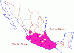
The table shows the 10 states which receive the highest total remittances.

RankStateRemittances ($ millions), 2005
1Michoacán2,595
2Guanajuato1,715
3Jalisco1,693
4State of México1,675
5Puebla1,174
6Veracruz1,155
7Federal District1,452
8Oaxaca1,002
9Guerrero957
10Hidalgo718
States receiving the most remittances (highest value)

States receiving the most remittances (highest value). Click to enlarge. All rights reserved.

The data show very clearly that all the states receiving high total amounts of remittances are in the southern half of Mexico.

(a) What factors might explain this pattern?

(b) Compare this map with a map of the states with highest per person remittances. Why are some states only shown on one of the maps, and not on the other?

(c) Find a table showing the total population of each state in Mexico. To what extent do the total population figures for each state help to explain whether or not they are in the top 10 states for receiving remittances?

“Migration to the USA” is the title of chapter 26 of Geo-Mexico: the geography and dynamics of modern Mexico. This chapter provides a good introduction to the geography, history and impacts of migration and remittances. Buy your copy today!

Jul 122010
 

The map shows the ten states which receive the highest remittances (funds sent home, primarily from the USA, by Mexican migrant workers) on a per person basis in 2005.

Map of states receiving most remittances per person

The states receiving most remittances per person, Click to enlarge. All rights reserved.

Many factors help to explain why some states receive high amounts of remittances, on a per person basis, while other states receive much less.

They include:

  • the number of migrant workers from that state working in USA
  • the poverty levels in the state
  • unemployment rates in the state
  • whether or not that state has a long history of supplying migrant workers

Perhaps surprisingly, there is no correlation between distance from the USA and the per person remittances sent back by migrant workers. On the contrary, it is clear that more remittances are received per person in several southern states. No northern border state is in the top 10 receiving states for remittances.

Why might this be? Perhaps workers from states nearer to the border return funds by non-official channels, such as with friends or relatives returning home. Perhaps life is so good in the northern states that fewer workers migrate.

(a) What other factors can you think of which might be relevant?

(b) Try to find data to help support (or refute) your ideas.

“Migration to the USA” is the title of chapter 26 of Geo-Mexico: the geography and dynamics of modern Mexico. This chapter provides a good introduction to the geography, history and impacts of migration and remittances. Buy your copy today!

The cultural geography of Mennonite enclaves in Mexico

 Excerpts from Geo-Mexico  Comments Off on The cultural geography of Mennonite enclaves in Mexico
Jun 082010
 

Among the first Mennonite settlers were a group of more than 1300 families (about 9300 individuals) of German-Russian descent who arrived from Canada in 1922. They had been guaranteed tax concessions, freedom of worship and exemption from military service by President Obregón. At the time the Mexican government wanted to encourage more settlement in northern Mexico which had unrealized agricultural potential. After the Mexican Revolution, the large landowners in northern Mexico wanted to sell part or all of their vast holdings before the federal government forced the break up of their estates.

Mennonites bought 100,000 hectares for 600,000 pesos (8.25 dollars per acre) and started a colony near Ciudad Cuauhtemoc, west of Chihuahua city.  The group’s spartan lifestyle is reflected in their conservative dress habits and the fact that their villages (campos) are numbered, rather than named.  The people are taller than the average Mexican, speak German, and have northern European physical features. Today, about 50,000 Mennonites live in the Ciudad Cuauhtemoc area. They also founded colonies at Patos, in northern Durango state, and near Saltillo in Coahuila. Today, there are also several Mennonite villages far to the south, in Campeche.

Mennonite cheese

Mennonite cheese (queso menonita)

The landscapes of Mennonite areas in northern Mexico are very distinctive. They transformed desolate areas of semi-arid scrubland into prosperous farms.

Houses built of adobe on wood frames line the main street of each campo. These elongated street villages (about sixty in number) are totally different to the compact, nucleated villages found elsewhere in Mexico.  Surrounding the villages are large relatively flat fields divided into blocks by wide roads.

The Mennonite farming areas look more like parts of the US Midwest than Mexico. The farms are neatly kept and dotted with wind pumps used to raise water for irrigation. Tractors are common though horse-drawn buggies are also used. The main crops are wheat, oats, beans, corn and in some areas apples. The Mennonites are experienced dairy farmers and their most famous contribution to Mexican cuisine is the production and marketing of Chihuahuan cheese (queso menonita). It is a common sight to see Mennonite men selling their delicious cheese at major intersections in several of Mexico’s major cities.

See also:

The geography of Mexico’s religions is discussed in chapter 11 of Geo-Mexico: the geography and dynamics of modern Mexico.

Mexico’s population will peak before 2050 but migration is harder to predict

 Updates to Geo-Mexico  Comments Off on Mexico’s population will peak before 2050 but migration is harder to predict
Jun 052010
 

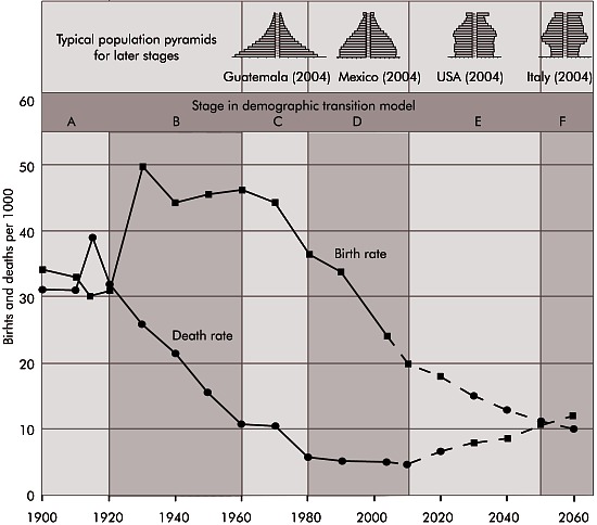
Past data and current trends indicate that Mexico is adhering to the demographic transition model (see post of 15 May 2010).

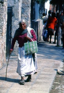
Mexico's population is aging rapidly

Death rates first dropped precipitously and now birth rates are declining rapidly. By the middle of the 21st century, these will be roughly equal and natural population growth will drop to zero. Then birth rates will drop below death rates and the population will begin to decline. This is already happening in Russia, Italy, Germany and Japan.
Mexico is expected to reach this situation before 2050 when its population will be between 120 and 130 million. This is a rather wide spread for a demographic forecast because predicting the rates of Mexican immigration to the USA is very tricky. Net immigration was over 550,000 in 2006, but dropped to about 200,000 in 2009 because the employment situation in the USA was so bad. When the recession ends and jobs are again plentiful in the USA, immigration will jump back up, but how far and for how many years?

As Mexico’s population growth rates continue to decline and become negative, the new challenge will be coping with a rapidly aging population. Fortunately, Mexico will be able to learn from Europe and Japan who are already facing this challenge.

Mexico’s population dynamics are discussed in chapters 8 and 9 of Geo-Mexico: the geography and dynamics of modern Mexico.

A summary of population trends in Mexico

 Mexico's geography in the Press  Comments Off on A summary of population trends in Mexico
May 262010
 

The Economist issue of April 24-30 had an interesting article entitled “Mexico’s population, when the niños run out. A falling birth rate and what it means.” Here are some of the figures quoted in that article:

Mexico's population is aging rapidly

Children per woman of child-bearing age.

  • 1960s: almost 7
  • today: just over 2 (about the same as the USA)

Average age

  • 1980: 17 years
  • 2010: 28 years (1 in 10 of the total population is aged 60 or older)

As the article emphasizes, in Mexico the trend towards an aging population “which took a century in Europe, has happened in three decades”. This trend has many implications for the provision of health care, social security and pensions. Such a rapid change towards an older population may also have a considerable impact on the rates of migration between Mexico and the USA.

The geography of Mexico’s population is analyzed in chapters 8 and 9 of Geo-Mexico: the geographyand dynamics of modern Mexico. Buy your copy today!

May 152010
 

Mexico’s population exploded in the mid-20th century as death rates plummeted and birth rates remained high.  From 1940 to 1980, the number of Mexicans more than quadrupled from under 20 million to over 80 million.  In the 1960s and 1970s the population growth was among the world’s fastest at 3.3% a year.  At this rate, the population doubles in less than 22 years.

Mexico's birth rates, death rates and demographic transition

Concerns about overpopulation resulted in a massive planning program which included health professionals, multimedia advertising, and messages is telenovelas (serialized TV dramas) and historietas (comic books).  As a result of this campaign and the demographic transition (the drop in fertility rates with modernization observed in all countries), the average number of children per woman dropped dramatically from 5.7 in 1976 to about 2.2 in 2010.  Mexico’s population should peak at about 120–130 million in about 2045.  This is a fairly large spread because accurately predicting future rates of immigration to the USA is very tricky.

Mexico’s natural increase now is about 1.5%, but actual increase (including immigration/emigration) was closer to 1% in 2006, 1.3% in 2008 and will probably be down to 1% again by 2011.

Mexico’s National Population Council (CONAPO) has projected a fertility rate of 2.1 for 2010, but international sources estimate it to be between 2.2 and 2.3 in 2010.

Mexico’s population dynamics are the subject of chapter 9 of Geo-Mexico: the geography and dynamics of modern Mexico; the importance of telenovelas and historietas is discussed in chapter 18.

Mexico tried to prevent Americans from migrating to Texas

 Other  Comments Off on Mexico tried to prevent Americans from migrating to Texas
Apr 092010
 

In recent years, considerable attention has focused on the US government’s efforts to stem the flow of Mexicans migrating north of the border in search of jobs. But there was a time in history when the boot was, so to speak, very much on the other foot.

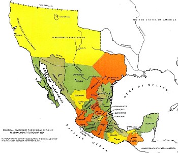
In the early 19th century, shortly after gaining her Independence from Spain (1821), Mexico’s territory extended considerably further north than it does today. It included modern-day Texas, as well as many other parts of what later became US territory.

The first British Chargé d’Affaires in Mexico was Sir Henry George Ward (1797-1860). Ward entered the diplomatic service in 1816, and first visited Mexico in 1823, as a member of a British government commission assessing the desirability of establishing trading relations following Independence. The following year, he married Emily Elizabeth Swinburne, who accompanied him on his return to Mexico in 1825 in his role as Chargé d’Affaires.

Map of Mexico, 1824

Two years later, Ward wrote a detailed description of how he saw Mexico. Mexico in 1827, which contains illustrations by his wife, was an early appraisal of the fledgling Mexican Republic, and was published on his return to the UK. Ward’s book provides numerous details of trade, mining, economic activity and topography, as well as pointing out many errors in Alexander von Humboldt’s earlier classic work Political Essay on the Kingdom of New Spain (1811).

Ward, a skilled diplomat, arrived only a few months before his American counterpart Joel Poinsett. (Poinsett, after whom the poinsettia is named, was the first US minister to Mexico). Ward was not only anti-Spanish, but also decidedly anti-American. His main goal, apparently, was to try to prevent the USA from expanding its territory at the expense of Mexico. The British diplomat believed that the incorporation of Texas into the Anglo-American states was inevitable unless the Mexican government could stem the wave of immigrants flooding southwards into the region. (How times have changed!)

The Mexican government was relatively unstable at this time, with frequent changes of leaders and some inconsistency in policies. Ward summed up the political situation that he encountered as one in which, after 13 years of civil war, the form of government had still not been determined, with great differences of opinion existing with respect to the desired degree of central authority. He found it difficult to conceive of any country less prepared than Mexico for the “transition from despotism to democracy”.

While both men were acting on behalf of their respective countries, Ward acted as a moderate balance to the interventionist politics of Poinsett. He promoted the signing of a UK-Mexico treaty of friendship, trade and migration, but the UK gradually lost influence in Mexico despite Ward’s best efforts. Meanwhile, Poinsett was trying his hardest to purchase Texas. His meddling in Mexican politics antagonized the government of Vicente Guerrero to the point where his recall was demanded in 1829.

The British Chargé d’Affaire’s greatest concern was that the USA might one day gain control over Texas ports. This would put them only three days away by boat from Tampico and Veracruz (Mexico’s main trading port) and mean that Mexico was vulnerable to invasion. Ward’s worst fears in this regard were realized later in the nineteenth century (the Mexican-American War of 1846-1848).

Original article on MexConnect.

The changing political boundaries of Mexico are described in chapter 12 of Geo-Mexico: the geography and dynamics of modern Mexico. Buy your copy today!

The Irish may be everywhere, but mainly due to a Mexican water mold

 Other  Comments Off on The Irish may be everywhere, but mainly due to a Mexican water mold
Mar 172010
 

During the Irish potato famine more than one million people died of starvation when their staple crop failed, and many of those who survived were forced to emigrate. This tide of emigration carried many Irish people to North America, particularly to the north-east of the USA.

How did the potato famine come about? The census of 1841 in Ireland recorded a population of about 8 million. This figure was a staggering 300% more than sixty years earlier. The staple Irish food at that time was the humble potato and Ireland’s rapid population growth during the early part of the nineteenth century was based on the so-called “potato economy”.  Ireland was bursting at the seams in 1841, but just a decade later, after the potato famine, the population had fallen to 6.5 million and by 1900 to around 4 million.

And where does a Mexican mold come in? The cause of famine was a water mold (Phytophthora infestans) that originated in Mexico. This fungus-like mold results in a disease called “late blight” in which entire fields of mature potato plants are destroyed within days. The name “late blight” is because the mold strikes late in the growing season, close to harvest time. Infected tubers are subject to soft-rot bacteria which render them useless as food. What is worse, the discarded rotting tubers can easily re-infect the succeeding year’s crop.

One kind of late blight mold, A1, crossed the Atlantic in the 1840s, reaching Europe in 1845 before rapidly spreading across the continent to reach Ireland. Although cultivated potatoes (Solanum tuberosum) originated in Peru, the late blight mold appears to have originated in the Toluca Valley of Mexico (adjacent to the western edge of Mexico City) where it is found in several related wild-growing Solanum tubers.

After the Irish potato famine, farmers learned to control the A1 mold through careful fungicide applications and by choosing varieties that had some resistance to late blight and planting only healthy tubers.

Since the 1980s, however, farmers are once again fighting late blight as the direct result of the escape of a second kind, A2, into the cultivated potato population. The problem stems from the fact that A1 and A2 can reproduce sexually, with the potential to have offspring that are strains with greater virulence or increased resistance to fungicides. Having two different kinds of late blight as parents greatly magnifies the genetic variability available for future generations of the mold .

The A2 mold first appeared outside Mexico in the 1970s and has already spread with serious economic consequences to the Middle East, Africa and North and South America. It seems almost certain that it will eventually also disrupt harvests in India and in China, the world’s largest potato producer. The A2 mold is considered the most important threat to potato cultivation worldwide. The current response of hitting it with higher and more lethal doses of fungicide is not in line with public demands for greener farming methods.

How did the A2 mold escape from Mexico? It was probably unintentionally carried by potatoes exported to Europe during the winter of 1976-77. Europe needed potatoes because a drought a year earlier had reduced its potato yields significantly. Unrecognized, the mold was then re-transported in seed potatoes throughout Europe and to the Middle East and Africa.

Scientists are studying wild potatoes in the Toluca Valley in an effort to try and identify precisely which gene or combination of genes provides these particular wild potatoes with some degree of defense against the worst ravages of the mold. Mexico’s main center for potato research is the Agricultural University at Chapingo, near Texcoco, on the eastern edge of Mexico City. The University is well worth a visit – if only to admire the magnificent Diego Rivera murals, including one of the world’s great nudes.

Happy St. Patrick’s Day, wherever you may be!

This is an edited version of an article originally published on MexConnect – Click here for the original article

Mexico’s innumerable links (economic, social, demographic and cultural) to the world are relevant to many chapters of Geo-Mexico: the geography and dynamics of modern Mexico.
Feb 222010
 

Mexicans have a long history of working and living in the USA. Migration is one of the most important linkages between North America’s two most populous countries. The Mexican diaspora in the USA is an integral part of both Mexican and US society. Each year roughly 250 million legal border crossings are made, about half by Mexicans. A much smaller number, perhaps a few hundred thousand, cross the border illegally despite US efforts to tighten border controls. The Mexican communities on either side of the border are very closely linked.

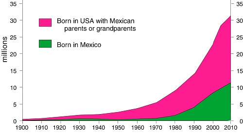
Mexicans in the USA
As of 2008 over 31 million Mexicans lived in the USA (see graph). This is more than one fifth of all Mexicans anywhere and a larger number than in any single Mexican state. Almost 19 million Mexican-Americans were born in the USA of Mexican parentage; these have always outnumbered migrants.

Roughly 10% of everyone born in Mexico now lives in the USA. This figure was only 5% as recently as 1990 and only 1.4% in 1970. Migrating Mexicans are as likely to move to the USA as within Mexico. Clearly, in recent decades, an increasing number of Mexicans have chosen to live in the USA.

[Extract from chapter 27 of Geo-Mexico: the geography and dynamics of modern Mexico]