In 2015, the USGS published a series of satellite images of environmental change [no longer online] of the area around the town of Angangueo in the eastern part of the state of Michoacán (very close to the border with the State of México) and the mountainous hillsides covered in pine-fir forest where the migrating Monarch butterflies spend their winters.
The pine-fir forests are found at an elevation of around 3000 meters (10,000 feet) above sea level. The butterflies congregate in a small number of locations, forming massive clumps on the trees. Any major disturbance, such as a windstorm or excessive snow, can cause the loss of (literally) millions of Monarchs. The overwintering Monarchs need just the right range of temperatures. On the one hand, they must not be so cold that they freeze or are not warm enough to flutter in search of food and water. On the other hand, if it is too warm, they may burn through their energy reserves or need to replenish too much moisture. The canopy of the pine-fir forest provides some protection, but even a partial thinning of this canopy will change the microclimate beneath.
In this post, we will will take a quick look at the images of Chincua reserve. This reserve includes the location where overwintering congregations of Monarch butterflies were reported for the first time in the mid-1970s. This is one of the areas where conservationists fear that the pine-fir forest (appearing vibrant red in the images) may have suffered too much clearing and thinning, which may have altered the area’s microclimate and made it unsuitable for successful overwintering.
When looking at the images, bear in mind that:
- Red signifies healthy vegetation.
- Landsat images are always taken in mid-morning, so shaded northwest slopes look darker. Shadows can vary slightly from one month to the next.
- The images show forest clearance, but do not reveal forest thinning. The consequences of forest thinning (the removal of individual trees) may be just as significant in the context of the annual Monarch butterfly migration.
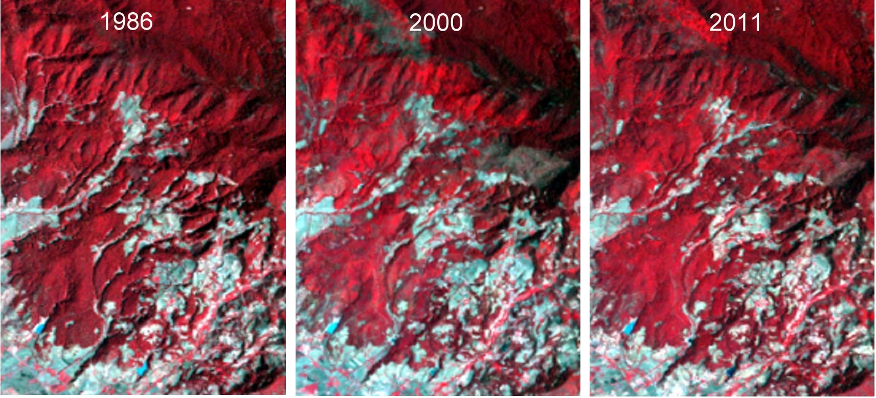
Satellite images of Chincua reserve, 1986, 2000 and 2011. Click to enlarge.
In the 2000 image, the Chincua reserve shows some rashy gray areas just above and to the right of the center of the image. These gray areas are not visible on the 1986 image. This may be evidence of a fire, or some other kind of clearing. The 2011 image seems to indicate that the vegetation in that area has recovered, at least to some extent.
A truly detailed examination of these images is beyond the scope of this short post, but high-resolution images (which can be downloaded from the USGS site) will repay a closer study. See, for example, the satellite images of Pelon.
Finally, it is worth remembering that the Monarch as a species is not endangered. There is, indeed, a year-round population of Monarchs in central and western Mexico that is non-migratory owing to the ready availability of milkweed, the only plant on which female Monarchs lay their eggs, throughout the year. It is only the butterfly migration that is considered an “endangered phenomenon”, and all three countries involved (Canada, USA and Mexico) have now instituted programs to try to ensure its long-term success.
Satellite monitoring of the areas of importance to the Monarch butterfly should help identify the key areas on which conservation efforts need to be focused.
Related posts:

Sorry, the comment form is closed at this time.