The transformation of Chapala from fishing village to international tourist destination

 Other  Comments Off on The transformation of Chapala from fishing village to international tourist destination
Sep 032020
 

The town of Chapala, on the shores of Lake Chapala—Mexico’s largest natural lake—played an important role in the history of tourism in North America and has become one of the world’s premier retirement destinations. Yet, the details of how and why this transformation occurred have never been adequately reconstructed… until now!

Geo-Mexico is reader-supported. Purchases made via links on our site may, at no cost to you, earn us an affiliate commission. Learn more.

My latest book If Walls Could Talk: Chapala’s historic buildings and their former occupants, reveals the results of more than two decades of research. The book explores the history of the town’s formative years and shares the remarkable and revealing stories of its many historic buildings and their former residents.

The front cover shows the waterfront of Chapala at the start of the twentieth century. On the right is the parish church of San Francisco, which dates back to the sixteenth century and features in D. H. Lawrence‘s novel The Plumed Serpent, set at the lake. (The house Lawrence rented in 1923 is now a boutique bed and breakfast.) The turreted tower on the left is part of the Villa Ana Victoria which was built by the Collignon family of Guadalajara in the 1890s, right at the start of the village’s explosive growth.

The illustration is a photograph by American photographer Winfield Scott that was colorized and published in about 1905 by Jakob Granat, a postcard publisher based in Mexico City.

In 1890, Chapala was a small fishing village. Within decades it became an important international tourist destination. This book explains how and why this transformation took place, and looks at the architects, entrepreneurs, adventurers and visionaries responsible. The cast of characters includes Mexican and British politicians and diplomats, as well as the eccentric Englishman Septimus Crowe, who abandoned his wife and child in Norway and carved out a new life for himself by investing in Mexican mines and importing a German-built yacht to sail the lake. Crowe was the area’s first real estate developer and pressured friends and acquaintances to join him in Chapala. One of the town’s central streets is named after him.

Chapala’s transformation into an international tourist destination was aided by its links to dictatorial President Porfirio Díaz, whose wife’s relatives lived on the outskirts of the town, and by a host of business leaders and wealthy, high society families from Mexico City and Guadalajara.

The story of Chapala is truly international. The visionary Norwegian entrepreneur Christian Schjetnan refused to take no for an answer as he worked tirelessly to organize a Chapala Development Company, start a yacht club, run steamboats on the lake, and build a branch railroad linking Chapala to the Central Mexican Railroad mainline at La Capilla, near Atequiza.

Chapala’s first major hotel, the Hotel Arzapalo which opened in 1898, was built by a Mexican businessmen and had a succession of Italian managers, some more honest than others. Many members of the extensive French and German communities in Guadalajara also played key roles in the area, both by building private family villas in Chapala and by helping finance improvements and public buildings in the town.

Organized as a walking tour of Chapala, each of the 42 chapters of If Walls Could Talk focuses on a different building and explores the fascinating stories of its former occupants—locals and foreigners. The valuable legacy left by these extraordinary individuals is still clearly visible today in the streets, villas, hotels and grand mansions of this idyllic lakeside locale.

The book includes more than 40 vintage photographs and four original maps showing how Chapala’s street plan has changed over the years. The text is supported by a bibliography, index and detailed reference notes.

The development of Huatulco, the tourist resort in southern Oaxaca

 Other  Comments Off on The development of Huatulco, the tourist resort in southern Oaxaca
Jan 302017
 

Huatulco is best known as one of Mexico’s leading tourist resorts, one of several similar large-scale, purpose-built developments partially funded by federal funds.

In 1967, responding to bullish predictions of US demand for beach vacations, Mexico’s central bank identified the five best places for completely new, purpose-built tourist resorts. Top of the list, as part of a 30-year plan, was the uninhabited barrier island now known as Cancún (see The growth of Cancún, Mexico leading tourist resort). The other choice locations were Ixtapa, Los Cabos, Loreto and Huatulco. The National Fund for Tourism Infrastructure (renamed the National Tourism Development Fund, Fonatur, in 1974) began building Cancún in 1970 and Ixtapa in 1971.

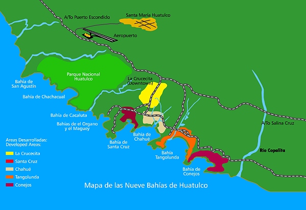
Huatulco’s site on the coast of Oaxaca had been initially identified in 1969 but the area lacked adequate transportation infrastructure until the regional highways were improved in 1982. Legal land expropriations followed; by 1984 Fonatur controlled more than 21,000 hectares (50,000 acres). In 1985 Fonatur began construction of an airport and a service town, La Crucecita, a few kilometers back from the coast. In 1986 the villagers of the coastal community of Santa Cruz were resettled in La Crucecita. Most of Huatulco’s nine bays were linked by paved road by 1987 (see map).

Sketch map of Huatulco (not to scale)

Sketch map of Huatulco (not to scale)

Fonatur took a number of steps to help the original residents adapt to the massive changes taking place around them. It built schools, held public meetings, provided medical and police services, and offered job training programs. Most people gradually adapted; some are employed in Huatulco hotels and some started their own small businesses. By 1994 Huatulco had 1905 hotel rooms and attracted 170,000 tourists, 26% of them foreign. The average length of stay was 4.22 days.

Huatulco’s growth has not been as rapid as Cancún’s. By 2006, Huatulco had 2506 rooms and played host to 312,000 tourists (15% foreign). While Cancún first attracted Mexican tourists and then foreign tourists followed (and now dominate), in Huatulco the proportion of foreign tourists has fallen as the resort has developed. The master plan for Huatulco foresees 30,000 hotel rooms and a city with an eventual population of 600,000.

As for most of its other developments, Fonatur’s construction of La Crucecita established a clear spatial and visual divide between the tourist areas on the coast and the residential areas for tourism employees, in this case on the inland side of some low hills.

So far, so good, but critics of centrally-planned, “top-down” resorts like those built by Fonatur, and of Huatulco in particular, point to the tremendous strains placed on the local inhabitants and on the local environment. We look at some of these in more detail in Villages near Huatulco, Oaxaca: a case study in the “Integrated Administration of Natural Resources”

Related posts:

Aug 152016
 

Avid Geo-Mexico readers will know that we included a few paragraphs about the Happy Planet Index in our 2010 book, which we later quoted in this 2013 post, Mexico and the Happy Planet Index.

The latest (2016) Happy Planet Index (HPI), which uses slightly modified criteria, shows that Mexico has risen to 2nd place in the world rankings, behind Costa Rica, but ahead of Colombia, Vanuatu and Vietnam and well ahead of the U.S. (#108) and Canada (#85).

The Happy Planet Index is a compound index that combines four measures:

  • life expectancy
  • well being (life satisfaction)
  • ecological footprint
  • inequality

The HPI looked at data for 140 countries. For life expectancy, Mexico ranked #39, for well being #11, for ecological footprint #77 and for inequality #60.

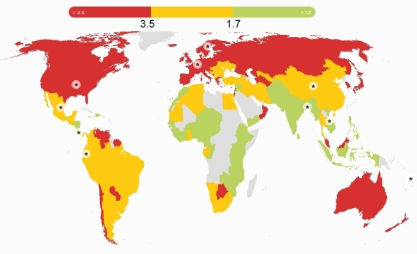
Global pattern of ecological footprint. Source: HPI report, 2016.

Global pattern of ecological footprint. Source: HPI report, 2016.

The world map for ecological footprint shows the global pattern. The colors show three categories for ecological footprints, those below 1.7, those between 1.7 and 3.5 and those that exceed 3.5, where the numbers are global hectares (gha) per person.

These two sections from the Happy Planet Index country report for Mexico are a useful snapshot of where Mexico stands right now:

What’s working well in Mexico?

In recent years, massive steps have been taken to improve the health of the population of Mexico – notably achieving universal health coverage in 2012, making essential health services available to the entire population.

In 2014, a tax was imposed on sugary drinks with the express aim of tackling of obesity – this despite strong corporate opposition. The tax had already led to a 12% decrease in the consumption of such drinks by the end of the year.

Environmental sustainability is receiving growing political attention, and was included as one of five key pillars in Mexico’s National Development Plan for 2007–12. Mexico was the second country in the world to incorporate long-term climate targets into national legislation, and is taking important steps to conserve its forests and protect its rich biodiversity.

What could be improved?

Significant challenges remain for Mexico: economic inequality is a massive problem with a considerable gap between the richest and poorest – the top 20% of the population earns more than thirteen times as much as the bottom 20% of the population.

Mexico’s poverty rates are particularly high among indigenous people. Amnesty International has  highlighted Mexico’s human rights violations, especially relating to irregular migrants. On top of these issues, the importance of the oil industry to Mexico’s economy complicates its environmental efforts.

Mexico recently reached cross-party agreement on the Pacto por Mexico, a pact of 95 initiatives aiming to tackle some of these issues – an important step for the country’s future.

The HPI attempts to quantify an alternative vision of progress where people strive for happy and healthy lives alongside ecological efficiency in how they use resources. Mexico may have a high happiness index, but (like the rest of the world) it still has an awful long way to go to ensure a sustainable future for our grandchildren.

Related posts:

Jun 232016
 

At the Mexico-China Forum for Cooperation in Mexico City in May 2016, authorities from China’s Guangdong Province met with Mexican officials and discussed plans to invest in Mexico’s recently-established Special Economic Zones.

special-economic-zones

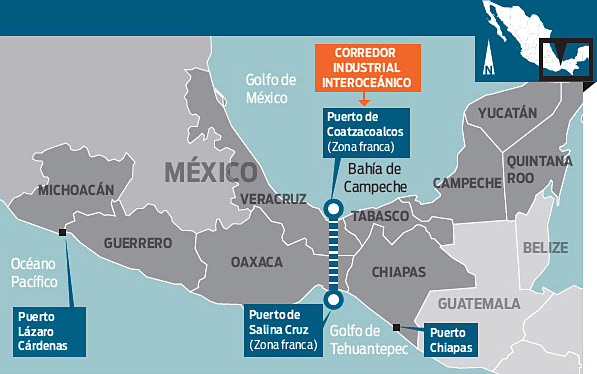
These zones offer tax benefits and support services to investors in order to generate new sources of employment in southern Mexico (Guerrero, Oaxaca, Chiapas, Michoacán, Veracruz and Tabasco).

Trade between Guangdong Province and Mexico was worth $10.4 billion last year, 25% of the two countries’ total trade. Chinese firms are considering projects related to aerospace, vehicles, electronics and energy, which could add $480 million in foreign direct investment. In support of closer ties between Mexico and China, China Southern Airlines plans direct flights between Guangdong and Mexico starting next year, which would serve business travelers and also boost tourism.

Mexico’s tourism development policies: a model for the world?

 Mexico's geography in the Press  Comments Off on Mexico’s tourism development policies: a model for the world?
Aug 272015
 

Mexico welcomed a record number of tourist last year: 29.1 million visitors, a 20.5% increase over 2013. The number of tourists is projected to grow 8% this year. Most tourists visiting Mexico come from the U.S., followed by Canada, U.K., Colombia and Brazil. During the first six months of 2015, the average expenditure/tourist was 865 dollars.

Mexico is the top international destination for U.S. tourists and according to U.S. Commerce Department data, visits to Mexico by U.S. tourists rose 24% in 2014 to a record 25.9 million, despite U.S. travel warnings relating to parts of the country. Figures from the Mexican side of the border suggest a more modest, though still substantial, increase of 11.8% in U.S. tourists entering the country. The differences in the figures reflect slight differences in definitions and methodology.

Just how did Mexico achieve its tourism success? The answer appears to be a combination of its fortuitous proximity to the USA allied with some smart policy decisions. This helps to explain why the Organisation for Economic Cooperation and Development (OECD) has chosen Mexico as the basis for developing a transferable model to demonstrate the potential of tourism in international development. The in-depth study, to be published next year, will focus on the economic and political aspects of international tourism.

Related posts:

An update on the Human Development Index in Mexico

 Updates to Geo-Mexico  Comments Off on An update on the Human Development Index in Mexico
Mar 192015
 

The latest United National Development Program (UNDP) report about the Human Development Index (HDI) in Mexico gives scores and ranks for each state. The full report, in Spanish, entitled “Índice de Desarrollo Humano para las entidades federativas, México 2015: Avance continuo, diferencias persistentes“, is readily available online, and is based on data up to and including 2012.

The HDI is a compound index based on several aspects of three major criteria: health, education and income.

HDI improved between 2008 and 2012 in all states except Baja California Sur. The greatest percentage increases in HDI were in Puebla (where HDI rose 3.7%), Chiapas (3.6%) and Campeche (3.6%). HDI in Baja California Sur fell 0.8%, mainly due to a lower score for education.

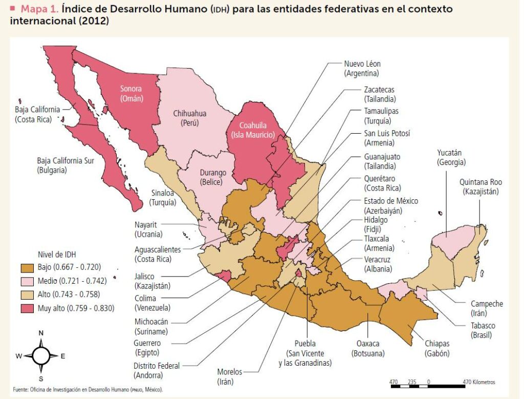
HDI in Mexico, with comparison countries for each state

HDI in Mexico, with comparison countries for each state. Click map to enlarge.

The pattern of HDI in Mexico, by state, is shown on the map. The highest HDI values in 2012 were for the Federal District with a score of 0.830, Nuevo León (0.790) and Sonora (0.779). At the other end of the spectrum, Chiapas had the lowest HDI (0.667), below Guerrero (0.679) and Oaxaca (0.681).

As noted previously on Geo-Mexico, the north-south divide in Mexico persists. In general, northern states, together with the Yucatán Peninsula states (Campeche, Yucatán and Quintana Roo) all have HDI values considered “medium” or higher, while southern Mexico (plus some other states, including Zacatecas, Guanajuato, Michoacán and Veracruz) all have “low” values.

The map includes international comparisons. For example, Oaxaca, one of most deprived states in Mexico, had a level of HDI in 2012 comparable to that of Botswana in Africa, even though that nation’s HDI is actually 38 positions below that of Mexico in the world rankings.

The report highlights the extent of disparities by calculating the number of years it will take each state, at the rates of change experienced from 2008 to 2012 to reach the HDI level of Mexico City. Interestingly, while it will apparently take Chihuahua 200 years to reach the HDI level of Mexico City, it will take Chiapas only 20 years to reach the same point.

The main conclusion that can be drawn is that the overall quality of life continues to improve in Mexico though not at equal rates throughout  the country. Disparities persist and current patterns of public spending have failed to make significant inroads into diminishing these disparities. The UN report considers it a priority to close the development gaps in Mexico, especially in the two southern states of Chiapas and Oaxaca.

Related posts:
Mar 122015
 

If you really want to learn more about Mexico’s economy and have a few hours to spare, then the free, open, online video course entitled Mexico’s Economy: Current Prospects and History by MRUniversity is the place to go. The lead instructor is Dr. Robin Grier of the University of Oklahoma. In a series of 51 short videos, she provides an outstanding analysis of Mexico’s economic history and current economic issues.

The course summary reads:

Is Mexico the most dynamic economy in Latin America?  After some tough times in the 1980s and 90s, Mexico has emerged as one of the economic leaders of the region.  Where does it stand among other emerging markets and what are its prospects for the future? In this four-week course, we will study the modern Mexican economy, some of the unique elements of development in a one-party, authoritarian regime, and some of the challenges the country faced in getting to this point.

No prior knowledge of economics (or of Mexico’s geography) is needed to follow the clear and concise min-lectures given by Dr. Grier, though many of her main lines of inquiry will be more than familiar to readers of Geo-Mexico.

There is lots of interesting material in these videos. For example, a short lecture under “Social Issues” entitled “Is There A Height Premium in Mexico?” looks at the evidence that taller people in Mexico earn more and have better economic opportunities than shorter Mexicans, before concluding that “each centimeter of height above the average is equivalent to 2% higher wages”. (Note: This video is a great follow-up to our April 2013 post, How tall is the average Mexican?)

The full list of videos in Mexico’s Economy: Current Prospects and History is

  • 1 An Overview of the Mexican Economy
    • Achievements
    • Challenges & prospects for reform
  • 2 Colonial Legacies: Obstacles to Growth after Independence
    • A reversal of fortune
    • Colonial Transportation Part I
    • Colonial Transportation Part II
    • Political Instability After Independence
    • The Economic Effects of the War of Independence
    • Transportation & Infrastructure in the 19th century
    • Slow Financial Development in Early Mexico
    • Law and Economic Development in Early Mexico
  • 3 Development Strategies
    • State-led development: an overview from 1917-1982
    • Commodity Driven Growth before the 1930s
    • Turning Inward: Industrial Policy after the Great Depression
    • Labor Unions and the PRI until democratization
    • What is a maquiladora?    An overview of Pemex
    • The problems of Pemex
    • Pemex’s poor performance
  • 4 Social Issues
    • Fertility and Demographic Change in Mexico
    • Is There A Height Premium in Mexico?
    • Conditional Cash Transfers
    • Migration and its Wage Effects in the US
    • Migration and Remittances
    • Economics of the Drug War
    • Finance, Law & Trust (Mexico)
    • Education Quality in Mexico
    • Education Inequality in Mexico
    • Why is Teaching Quality so Low?
  • 5 Land & Agriculture
    • Land Reform in an Authoritarian State
    • The Economic Life of the Tortilla
    • A Tomato Border Crossing
    • Watermelon Scale Economies
  • 6 The Debt Crisis of the 1980s
    • External Factors of the Debt Crisis
    • Domestic Factors of the Debt Crisis
    • Resolving the Debt Crisis
  • 7 The State Retreats: Reform in the 1980s & 1990s
    • External Factors Behind Reform
    • Privatization Part I: The state loosens its grip
    • Privatization Part 1a: Charges of Cronyism and Corruption
    • Privatization 2: Dealing with the Opposition
    • Privatization 3: Results
  • 8 The Peso Crisis
    • The Mexican Miracle? The Lead-Up to the Tequila Crisis
    • Tequila crisis
  • 9 NAFTA & the Mexican Economy
    • An Introduction to NAFTA
    • The effects of NAFTA on the Mexican economy
    • NAFTA and Mexican Agriculture
    • FDI & NAFTA
  • 10 Modern Mexico
    • Mexico & the Brics
    • Is Mexico the new China?
    • La Reconquista: Mexican direct investment in the US
    • Mexico as an open economy
    • Mexico and the 2008 Global Financial Crisis

The course is an outstanding resource for teachers and students of geography and economics, and worthy of wide use in a range of high-school A-level and IB courses as well as college and university programs.

Oct 202014
 

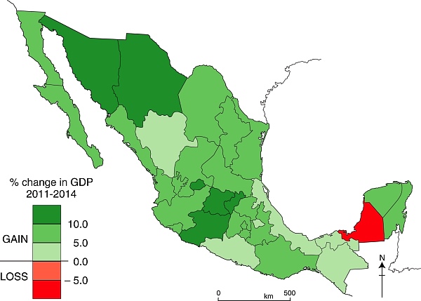
Which of Mexico’s states have the fastest growing economies? The map below, based on INEGI data, shows each state’s percentage change in GDP for the three year period from 31 March 2011 to 31 March 2014.

Change in GDP by state, 2011-2014. Data: INEGI. Credit: Geo-Mexico

Change in GDP by state, 2011-2014. Data: INEGI. Credit: Geo-Mexico

Only one state – Campeche – registered “negative growth” over the period. In Campeche, production from the oil fields that have long been a mainstay of the local economy has been gradually declining.

Besides Campeche, six states grew far slower than the average for Mexico: Durango, Veracruz, Tabasco, Chiapas and Guerrero. Not entirely coincidentally, several of these states are among the poorest in the nation, so their failure to grow as quickly as the average leaves them further behind, increasing the economic inequalities that plague Mexico’s development.

At the other end of the spectrum, the economic growth of six states – Sonora, Chihuahua, Aguascalientes, Guanajuato, Michoacán and Querétaro – easily outpaced the average for the country. Sonora, Chihuahua, Guanjuato, Querétaro, and to a lesser extent Aguascalientes, all benefited from foreign direct investments and new industries, such as those involved in  the vehicle manufacturing and aeronautical sectors.

The case of Michoacán is something of an anomaly, since that state’s economy is still heavily dependent on primary products such as avocados and iron ore. The positive growth in that state may prove to be mainly due to its negative growth in the preceding three years (2008-2011), which meant that it started the three year period shown on the map at an unusually low level. Perhaps more importantly, given the state’s recent political upheavals and gang-related violence, it is highly unlikely that Michoacán will continue to grow anywhere as quickly over the next three years.

Related posts:

Update on Mexico and the UN Millennium Development Goals (MDGs)

 Mexico's geography in the Press  Comments Off on Update on Mexico and the UN Millennium Development Goals (MDGs)
Dec 302013
 

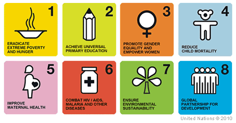
More than 190 countries signed up to the 2015 UN Millennium Development Goals (MDGs), agreed in 2000. There are 8 major goals:

  1. eradicate extreme poverty and hunger
  2. achieve universal primary education
  3. promote gender equality and empower women
  4. reduce child mortality
  5. improve maternal health
  6. combat HIV/AIDS, malaria and other diseases
  7. ensure environmental sustainability
  8. develop a global partnership for development

millenium-development-goalsMexico is well on its way to meeting most of the eight goals, according to the technical committee established to monitor the country’s progress. The technical committee includes representatives from various government departments, as well as INEGI (the National Geography and Statistics Institute) and CONAPO (the National Population Council).

The committee reports that Mexico has already met the targets for 38 (74.5%) of the 51 quantitative indicators used to assess progress towards the 8 goals, and is continuing work towards meeting the remaining targets by 2015 (the deadline for the Millennium Development Goals).

Satisfactory or good progress is being made on 5 of the remaining 13 indicators; all five are expected to be met sometime in 2015.  Progress on the other 8 indicators has been slower than needed, and it now seems highly unlikely that goal 7 (environmental sustainability) can possibly be met.

Specific targets that Mexico has not yet reached and where progress has either stagnated, or deterioration has occurred, include:

  • Decrease in mortality rate per 100,000 inhabitants due to HIV/AIDS  (part of goal 6)
  • Total carbon dioxide emissions (part of goal 7)
  • Proportion of total water resources already in use (part of goal 7)
  • Percentage of inhabitants with private dwellings using charcoal or wood for cooking (part of goal 7)

Related posts:

Are Aztec chinampas a good model for food production and agro-development?

 Other  Comments Off on Are Aztec chinampas a good model for food production and agro-development?
Oct 072013
 

There is no doubt that Mexico’s indigenous farmers developed numerous ways to ensure successful harvests. The details varied from one region to another, but among the techniques employed were:

  • the mitigation of erosion by building earth banks and check dams in gullies
  • polyculture, recognizing that this minimized the risks inherent in monoculture.
  • the terracing of steep slopes to channel water where it was most needed.

In addition, some indigenous groups, including the Aztec in central Mexico, took advantage of their expertise in water management to develop highly productive systems of farming in wetlands. The chinampas (or so-called ‘floating gardens’) in the Valley of Mexico are the prime example of this water management skill, though similar systems were also used in the coastal marshes along the Gulf coast.

On the other hand, the later introduction of large-scale commercial farming methods has often led to deleterious impacts on the countryside and the long term sustainability of such methods is questionable.

In seeking to help Mexico’s rural areas, some development experts have suggested re-adopting Aztec methods, especially their method of building chinampas to farm wetlands. The invention of chinampas as a highly productive form of intensive wetland cultivation was, historically, one of the greatest ever agricultural advances in the Americas. Among other things, it allowed settlements to thrive in areas where rain (and therefore rain-fed food production) was markedly seasonal.

Among attempts to re-introduce ancient methods, one which stands out occurred in the 1970s and 1980s, when INIREB (Instituto Nacional de Investigaciones sobre Recursos Bióticos), based in Xalapa (Veracruz) employed chinamperos from the Valley of Mexico to build experimental chinampa-like fields in Veracruz and Tabasco . These projects are briefly described in Andrew Sluyter’s fascinating book Colonialism and Landscape, Postcolonial theory and applications (Rowman and Littlefield, 2002), the main basis for this summary.

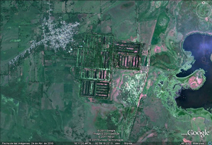
Google Earth image of camellones chontales

Google Earth image of camellones chontales

The most ambitious project was a later federally-organized one in Tabasco, where 65 massive platforms (camellones), each about 30 meters wide and from 100 to 300 meters long, were built in the swampy Chontalpa wetlands. The project, known as camellones chontales was backed by the local Chontal community though it was not directly involved in the construction phase. Because of the scale of the project, large mechanical dredgers were used to build the platforms, rather than relying on laborious and slower hand labor.

After construction, the Chontal community began farming the platforms, but initial results were very disappointing. Things improved with time, especially when the Chontal took full control of the project. From their perspective, the project meant that more members of the community now had land that could be farmed, and they shifted the emphasis away from the “vegetable market production” favored by officials towards growing corn (maize), beans and bananas for local household consumption, improving local food availability.

Recent press reports, such as this 2-minute Youtube clip (Spanish), claim that many parts of the camellones chantales have now been abandoned, owing to insufficient investment in maintenance.

Why did the project fail initially?

This is one of the key questions connected to this example. Sluyter refers to two articles written by Mac Chapin (from Cultural Survival, an organization that champions the rights of native peoples). Chapin argues that the projects, and their assumptions, were fundamentally flawed. For example, the use of dredges to construct the platforms turned the soil profile upside down, bringing infertile clay towards the top and sending nutrient-rich layers downwards, beneath the reach of plant roots. In turn, this meant that organic matter and fertilizers had to be added to the land in order for good crop yields. Because of the dredging, the canal floor between the platforms was very irregular, making it much more difficult for the Chontal to fish using drag nets. Many of the crops planted were “exotic” and production was market-oriented rather than subsistence or locally-oriented. Chapin was particularly critical of the lack of suitable transport routes for sending produce to distant markets. In addition, chemicals were needed because of the proliferation of insects in these lowland wetlands. (Insects are rarely a problem at the higher altitudes of central Mexico).

Chapin concluded that this development project was just one more in a long line of failures where an outside model was introduced into a new area without sufficient prior research or local involvement in the planning stages. Sluyter agrees with this conclusion, pointing out that there is no evidence that these Tabasco wetlands ever had any form of chinampa farming, even in pre-Columbian times, perhaps because they have “a much greater annual fluctuation in water level than those in Campeche and Veracruz”.

Want to read more?

Related posts:

Exclusive: Quintana Roo cacao megaproject collapses

 Other  Comments Off on Exclusive: Quintana Roo cacao megaproject collapses
Aug 302013
 

Following our critique of the Maya Biosana chocolate megaproject (Maya Biosana or Maya Bio-Insana? Chocolate megaproject in Quintana Roo),  a project which claimed it would plant four million cacao plants in four years, we have received additional information about developments in the Los Divorciados ejido where the project is based.

According to an insider, the project has now completely abandoned its plans for a massive cacao plantation. Jim Walsh, the former CEO of Maya Biosana, left the project in December 2012. Maya Biosana is now being managed by a Mexican firm AMSA (Agroindustrias Unidas de México, S.A. de CV) which is trying to convert the land into a profit-making venture producing corn and other grains.

Prior to the demise of the cacao megaproject, the organizers of Maya Biosana had released a short documentary detailing the project, and lauding its successful transformation of “a dwindling Mayan town” into a “now blossoming entrepreneurial city growing cacao fields and supporting their local community.” The film’s blurb claims that since the video was filmed, “the town has expanded and grown two-fold.”

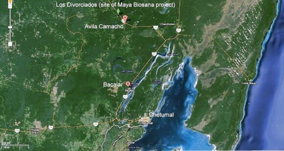
According to recent visitors to Los Divorciados (the ejido in question—see map), this could not be further from the truth. They report that in summer 2013, the Maya Biosana project, which had started out by employing around 200 people, now had 40 workers at most. One member of the group that visited Maya Biosana estimates, “based on the number of motorcyles parked there when we were there”, that the real workforce at Maya Biosana may be even smaller, perhaps 20-25.

Google Earth image of southern Quintana Roo

Google Earth image of southern Quintana Roo

The 13-minute documentary, “Maya Biosana – The Rebirth of Mexican Cacao, A short documentary,” can still be seen (as of August 2013) via http://intentionalchocolate-blog.com/2013/07/17/maya-biosana-the-rebirth-of-mexican-cacao-a-short-documentary/ on the Intentional Chocolate blog. However, note that many of the images included in the video are most definitely NOT from the Maya Biosana area, or even from Quintana Roo.

The film’s badly-written blurb claims that it, “follows Maya Biosana, as it repositions Mexico as the largest organic cocoa producer in the world and bringing the sacred plant back to it’s birth home. Improving the quality of life in Mexico with it’s vision of collaboration, co-creation and intention by providing the local and surrounding communities with a new model of business utilizing their own proprietary Well Being index as the marker of change.”

According to the Intentional Chocolate blog, “The film won the best short Award in 2012 at the Awareness Festival”, a claim it has also proved impossible to verify.

The original Maya Biosana is no more, but will the new management of this area by AMSA prove to be any better for the local ejidatarios than the original megaproject fiasco? We certainly hope so, but only time will tell.

In the interim, we received an e-mail  a few weeks ago about a new megaproject underway in Avila Camacho, the next village to Los Divorciados (see map). Apparently, this megaproject is for plantations of exotic trees, which involves deforesting the jungle, extracting the wood, and planting a total of 6000 hectares with White Teak (Gmelina arborea, Spanish common name melina), a tropical hardwood, at the rate of 1000 hectares a year. So far, about 50 hectares have already been planted.  The correspondent writes that they “stole the land of the Mayan people, cheating about the pay of rent: the rent is $45US for a hectare for a year. They are destroying the jungle  and extracting the wood.” We have been unable to get independent verification of these claims as yet, but will continue attempting to do so.

Initially, some equipment from Maya Biosana was utilized on the Avila Camacho project, and our correspondent  claims that it is the same Mexican-associated company that is responsible, though we have not yet been able to confirm this.  According to a second source, the CEO of this project is Fernando Gonzalez, a “very good friend of Jim Walsh”, the former CEO of Maya Biosana, but there is no longer any direct connection between the two projects.

There may have been recent “developments” in this part of Mexico, but they certainly do not yet constitute any form of sustainable development.

Related posts:

How does Mexico score on the Social Progress Index?

 Books and resources  Comments Off on How does Mexico score on the Social Progress Index?
May 302013
 

The Social Progress Index measures the extent to which countries provide for the social and environmental needs of their citizens. It is a compound index, based on  52 indicators in the areas of Basic Human Needs, Foundations of Wellbeing, and Opportunity that show relative performance in order to elevate the quality of discussion on national priorities and to guide social investment decisions.

Social progress is the capacity of a society to meet the basic human needs of its citizens, establish the building blocks that allow citizens and communities to enhance and sustain the quality of their lives, and create the conditions for all individuals to reach their full potential.

The model used to develop the index is based on asking three key questions that help define social progress:

  1. Does a country provide for its people’s most essential needs? (Basic Human Needs)
  2. Are the building blocks in place for individuals and communities to enhance and sustain wellbeing? (Foundations of Wellbeing)
  3. Is there opportunity for all individuals to reach their full potential? (Opportunity)

In this inaugural Social Progress Index, each of these dimensions is disaggregated into four components, each measured by between two and six specific indicators. Each indicator has been tested for internal validity and geographic availability:

Criteria used to compile Social Progress Index

Criteria used to compile Social Progress Index. Click image to enlarge.

For example the Personal Rights component of Opportunity is comprised of 5 separate variables:

  • Political Rights (Freedom House)
  • Freedom of Speech (CIRI Human Rights Data Project)
  • Freedom of Assembly/Association(CIRI Human Rights Data Project)
  • Private Property Rights (Heritage Foundation)
  • Women`s Property Rights (Economist Intelligence Unit)

How does Mexico score on the Social Progress Index?

Of issues covered by the Basic Human Needs Dimension, Mexico does best in areas including Nutrition and Basic Medical Care and has the greatest opportunity to improve human wellbeing by focusing more on Personal Safety. Of issues covered by the Foundations of Wellbeing Dimension, Mexico excels at providing building blocks for people’s lives such as Health and Wellness but would benefit from greater investment in Access to Information and Communications. Of issues covered by the Opportunity Dimension, Mexico outperforms in providing opportunities for people to improve their position in society and scores highly in Personal Rights yet falls short in Access to Higher Education.

This is how Mexico’s performance stacks up in comparison to the other 49 countries in the survey:

  • Social Progress Index: score 49.7 = rank 25th
  • Basic Human Needs: 49.3 (29th)
  • Foundations of Wellbeing: 50.8 (23rd)
  • Opportunity: 49.1 (25th)

This post is based on a press release from the Social Progress Imperative. For more information about the methodology behind the Social Progress Index, please refer to the inaugural report.

Related posts:
May 172013
 

Each year the United National Development Program (UNDP) publishes Human Development Index (HDI) scores and ranks for all countries with available data. The 2013 report, which is based on 2012 data, was just published. (Summary HDI 2013 Report: Rise of the South: Human Progress in a Diverse World)

The index takes account of three key development indicators:

  • Life expectancy at birth,
  • Literacy and school enrollment,
  • Gross National Income (GNI) per person (on a Purchasing Power Parity basis, which uses the total amount of goods and services produced in an economy, independent of exchange rates).

The HDI theoretically varies from 1.0 for the highest and 0.0 for the lowest. In the 2013 report, Norway is highest with a score of 0.955 while Congo and Niger are tied at rank 186 for lowest with scores of 0.304.

hdi-report-2013The latest report identifies Mexico along with 17 other countries that have made outstanding progress since 1990. This group of 18 includes none of the traditional industrialized countries. Those at the top of the progress list include South Korea, Chile, Mexico and Malaysia followed by such major countries as Brazil, Turkey, Thailand, China, Indonesia, India and Bangladesh. The HDI scores of all the world’s countries have improved significantly in the last 30 years; but the scores of non-western countries have increased spectacularly over this period.

While HDI scores receive considerable attention, the UNDP’s Inequality-Adjusted HDI or IHDI is a better overall measure because it is far less skewed by the extremely wealthy whose very high incomes push up the GNI per person values but do not adequately represent the development of the society as a whole. For example, the USA ranks third in HDI with a score of 0.937, due in part to the extreme wealth of its highest 1%. On the IHDI scale, the USA scores only 0.821 and ranks 16th.

Mexico’s HDI score is 0.775, but its IHDI score is of 0.593 is much lower because of the great inequality between the rich and poor in Mexico. In terms of IHDI, Mexico ranks 55th. This places Mexico well behind Chile (41st, 0.664), Argentina (43rd, 0.653) and Russia. (2012 data are not available for Russia, but 2011 data places it well ahead of Mexico.) On the other hand, Mexico’s IHDI score is ahead of Peru (62nd, 0.561), Turkey (63rd, 0.560), China (67th, 0.543), Brazil (70th, 0.531), Indonesia (79th, 0.514) and Egypt (0.503). Major countries that seriously trail this group include: India (91st, 0.392), Bangladesh (95th, 0.374), Pakistan (98th, 0.356), Kenya (102nd, 0.344), Nigeria (119th, 0.276) and Ethiopia (121st, 0.269).

The main conclusion is that the overall quality of life continues to improve rapidly in Mexico as well as in many other so-called developing countries. Current trends suggest these improvements will continue in the years ahead. The Congo, ranked 134, is last with a score of 0.172. IHDI scores are not available for many countries because they lack appropriate income distribution data.

Related posts:

Empty houses in Mexico

 Other  Comments Off on Empty houses in Mexico
Apr 082013
 

On-going rural-urban migration has led to a proliferation of metropolitan areas and the construction of millions of new homes across Mexico. Thirty years ago, there were only 15 recognized metropolitan areas in Mexico, today there are 59.

In recent decades, there has been insufficient coordination between the various government departments responsible for housing, services and land development, such that some settlements were authorized even though they lacked or had inadequate access to highways or basic services. In many instances, settlements were given the green light even though the ownership of the land was still in dispute.

A recent Mexico City news report entitled Desorden urbano dejó en el país millones de viviendas fantasmas claims that this poor planning in Mexico has resulted in as many as 4 million houses, many of them newly built, standing empty.

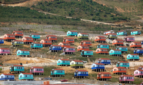
Among the settlements with a large number of uninhabited new homes is Santiago el Pinar in the heart of the southern state of Chiapas, home of the indigenous coffee–growing Tzotzil Indians who have traditionally lived in dispersed rural communities where access to central services is difficult. The previous federal administration built hundreds of homes here in its effort to “develop” the area into a “sustainable rural city” (whatever that means!). It was hoped that modern homes, located near services such a small, new hospital, would help give the Tzotzil a chance to escape poverty, though it did involve some relocation.

Santago el Pinar. Credit: glasgowchiapassolidaritygroup.wordpress.com

Santago el Pinar. Credit: glasgowchiapassolidaritygroup.wordpress.com

This BBC clip – Santiago el Pinar: One Square Mile of Mexico – describes the plan and some of the obstacles it has encountered.

The people’s traditional dwellings have dirt floors where food can be cooked over small fires. The new homes, designed by Marco Antonio Constantino, are mounted on stilts and have wooden floors, where traditional forms of indoor cooking would be hazardous. There were also some serious issues of construction quality, as well as a significant delay in supplying water to the new homes. All these factors combined have meant that almost all of the new homes have quickly been abandoned.

The lack of provision of basic services (water, electricity, drainage) is also cited as a factor why many new homes elsewhere in Mexico remain unoccupied.

In the past 20-30 years, Mexico’s largest homebuilders (companies such as Urbi, Geo and Homex) have done very well financially. They are now having to adjust to tougher times. Part of their problem, according to the Mexican financial press, is that government policy has shifted away from the construction of single-family units (such as those in Santiago de Pinar), which these big companies thrived on, towards building multi-family vertical units. The advantages of the latter are they reduce overall energy usage and the total cost associated with supplying other essential services.

This brief look at the issue of empty houses in Mexico suggests that while Mexico is certainly changing, and often for the better, change (as evidenced by Santiago de Pinar) is not necessarily synonymous with progress.

Want to read more?

Related posts:


Aug 162012
 

Six months ago, we gave an optimistic mention of Maya Biosana, a cacao megaproject in Quintana Roo, noting that it had received the support of the federal Agriculture Secretariat (Sagarpa):

We also noted that the project was not without its critics. In this post, we look at some of the claims, counterclaims and available evidence.

What is Maya Biosana?

The Maya Biosana project aims to make Mexico the leading producer of organic cacao in the Americas. In the early phases, Maya Biosana claims it will plant one million cacao trees to create 500 hectares (1200 acres) of irrigated orchards in 12 communities near Chetumal in Quintana Roo, with similar numbers of new trees to be planted annually for another three years. The trees are expected to yield 2.4 metric tons of cacao per hectare, produce 4800 metric tons of cacao a year (destined for high quality chocolates) by 2017 and provide up to 2,000 additional jobs.

A fuller description of the intended project (pdf file, in Spanish) is available on the Sagarpa website.

Pipedream or reality?

Industry insiders, such as Denver-based chocolate maker Steve DeVries, who leads specialist tours to the cacao growing regions of Mexico, Costa Rica and Ecuador, have drawn our attention to the fact that such numbers will be virtually impossible to achieve. In their view, producing and planting one million cacao plants will take far longer than a year, even in ideal circumstances. They also point out that a million trees on 500 hectares would be an average planting density of 2000 plants/hectare. According to the Food and Agriculture Organization (FAO), about half that figure, 1025 plants/hectare, would be a more normal spacing.

The Maya Biosana project apparently intends to plant only cacao Criollo. Of the three main varieties of cacao (see further reading for more details) – Forastero, Criollo and Trinitario –  Criollo produces the most flavorful chocolate, but is little used at present in the mainstream chocolate industry because it is very susceptible to disease, and takes longer to reach maturity. The most widely grown variety is Forastero, which is hardy but least flavorful, while Trinitario, a hybrid of the first two, falls somewhere in the middle.

This makes Criollo a very strange choice for such a major plantation. In fact, industry insiders say, there is no source anywhere in Mexico for the huge quantity of Criollo grafts that the Maya Biosana project would require.

Maya Biosana claims that the first phase of its megaproject is already underway on land in the Los Divorciados ejido, about 100 km from Chetumal, and recently released a promotional video. The film includes lots of “feel good” footage and memorable quotes, but some of the footage of mature cacao appears to have been shot elsewhere, presumably in Tabasco state. More importantly, what exactly does the Maya Biosana team bring to the table, besides good intentions?

Who are the main players in Maya Biosana?

The two main players in Maya BioSana, according to press reports, are Jim Walsh and Fernando Manzanilla.

Entrepreneur Jim Walsh is the self-styled “reinventor of chocolate”, CEO of Hawaiian Vintage Chocolate from 1992, and CEO of the closely-related Intentional Chocolate since 2007. Fernando Manzanilla Prieto is a well-connected Mexican politician, member of Partido Acción Nacional (PAN), and businessman who is currently the Secretary General of the government of the state of Puebla in central Mexico.

According to its website, samples of Intentional Chocolate, co-founded by Walsh and Manzanilla, were given by former president Bill Clinton as a gift to the Japanese Royal family and have the seal of approval of the Dalai Lama. The company “treats” regular chocolate using “breakthrough licensed technology” that “helps embed the focused good intentions of experienced meditators and then infuses those intentions into chocolate”. An early press release stated that such chocolate can “significantly decrease stress, increase calmness, and lessen fatigue in those who consume it”.

The major claim made for this chocolate is that it elevates the mood of consumers more than non-intentioned chocolate does. This claim is based, apparently in its entirety, on a single “double-blind, randomized, placebo-controlled experiment”, the results of which were published in an article, co-authored by Walsh, entitled Effects of Intentionally Enhanced Chocolate on Mood in EXPLORE: The Journal of Science & Healing, an Elsevier journal, in the September/October issue of 2007 (Vol 3, No 5: 485-492).

The sample size was small, 62 individuals in total. For one week, participants self-recorded their mood by means of a recognized “profile of mood states”. Some participants consumed “intentioned” chocolate, and others “non-intentioned” chocolate, twice a day, at the same times, for three consecutive days, in the middle of the week.

The most fascinating part of the article is actually the last paragraph, where the authors recommend that efforts to replicate the findings should “seriously consider sources of intentional enhancement and contamination that might influence the postulated effect.” They call for intentional imprints to be provided only by “highly experienced meditators or other practitioners”, writing that “persons holding explicitly negative expectations should not be allowed to participate for the same reason that dirty test tubes are not allowed in biology experiments.” Even more bizarrely, they claim that vigilance about the intentions of people involved in the test may even extend to “people who learn about the experiment in the future after the study is completed”.

Put another way, skeptics and disbelievers should stay home.

To the best of our knowledge, the Explore study has not been replicated, while statisticians and others have criticized the methods used and the conclusions drawn. See, for example, Debunked: Effects of Intentionally Enhanced Chocolate on Mood.

The other two authors of the Explore study besides Walsh are Dean Radin and Gail Hayssen. Radin is a prolific author of articles about parapsychology and also just happens to be a co-editor of Explore. Both Radin and Hayssen hold posts at the Institute of Noetic Sciences in Petaluma, California.

Walsh and Radin, together with Manzanilla, all have connections to the Human Energy Systems Alliance (HESA) Institute,  “an alliance of scientists, philosophers, entrepreneurs, and spiritual leaders devoted to unlocking the potential of the human energy system and to developing technologies and products that transform human health and increase human flourishing.”

According to the HESA Institute’s list of its main members (webpage no longer active) , Walsh is the institute’s founder and CEO, and Radin is a prominent member. Manzanilla’s bio claims that he was, too, founded HESA but, curiously, his name is absent from the HESA Institute list.

Between them, Walsh and Manzanilla have created an impressive web of interlinked and overlapping projects, supported by an equally dazzling range of positions on advisory boards. For example, both men are members of the three-person advisory board of the Institute for Spirituality and Wellness (ISW) at the Chicago Theological Seminary (CTS), which continues “to educate and prepare future leaders for a multitude of ministries” (Ref). The CTS is an affiliated seminary of the United Church of Christ, “a mainline Protestant Christian denomination primarily in the Reformed tradition but also historically influenced by Lutheranism” (Ref).

Several of the projects associated with Manzanilla, according to his CTS bio, have surprisingly little or no web presence. For example, he founded (in 2007 according to his Linkedin profile) and remains CEO of ImaginaMéxico, which “directs a network of organizations whose brands encompass the areas of food and beverages, agro forestry and wellness, human capital and technology, all under the common theme of helping individuals lead more meaningful and vital lives.” Yet, as of last week, the ImaginaMéxico website was “under construction”. According to the bio, Manzanilla also founded Cielo y Tierra (no web links found), Facthum-Mexico (no website found) and Kakaw Universal (no evidence from a Google search that it even exists)…. Manzanilla also co-founded Baja BioSana,  “an intentional community with a vision to become an example of sustainable living and educational center” (Ref) located in the small village of El Choro in Baja Califórnia Sur.

Financial shenanigans

It now looks as if the Maya Biosana project may be dead in the water, before it ever really gets off the ground. According to this document from the Superior Audit Office of Mexico (Auditoría Superior de la Federación), Maya BioSana received two payments in 2010 from Financiera Rural, acting on behalf of Sagarpa, as part of the latter’s  Strategic Project for Sustainable Rural Development in the South-South-East Region of Mexico (Proyecto Estratégico para el Desarrollo Rural Sustentable de la Región Sur Sureste de México). The two payments totaled 15 million pesos (about $1,140,000 dollars).  The document states that Sagarpa is already requesting the return of these funds because the Maya Biosana project has fallen behind schedule.

The Superior Audit Office document says that visits to the site did not find any cacao plantation and alleges that the Sagarpa funds had been transferred from one company account to another before a payment for 12,400 million pesos (about $946,000 dollars) was made to a foreign bank account belonging to one of the individuals who had signed on behalf of the company “Maya Biosana S.A.P.I de C.V.” Perhaps this was the cost of the recently-released video?

For the sake of the ejidatorios of Los Divorciados in Quintana Roo, who were counting on the success of the Maya BioSana cacao-growing megaproject, we hope that they have gained, and will gain, more from this experience than they lost. They deserve far better than a mere handful of chocolate-coated intentions.

This is one chocolate megaproject that appears to be melting fast. Maya BioSana looks much more like Maya Bio-Insana.

Further reading:

  • Cacao domestication I: the origin of the cacao cultivated by the Mayas
  • Cacao domestication II: progenitor germplasm of the Trinitario cacao cultivar

Related posts:

Mar 052012
 

In a previous post–The development of Huatulco, the tourist resort in southern Oaxaca–we looked at how the tourist resort of Huatulco was created by Mexico’s National Tourism Development Fund (Fonatur) on a series of small bays in the state of Oaxaca. Clearly, this development was very much “top-down” and it has been widely criticized from many distinct points of view. From a geographical perspective, the most important criticisms have arisen from researchers such as Evelinda Santiago Jiménez and David Barkin, co-authors of a short article entitled “Local Participation and Sustainability: a study of three rural communities in Oaxaca, Southern Mexico.”

Their view is that government programs, such as Huatulco, “are generally conceived for areas where there are resources that can be transformed into commodities”. In the case of Huatulco, this means that “access to public services, such as potable water, is designed to satisfy the demands of the visitors and affluent local service providers, while the majority suffer from inadequate supplies and must accept the conditions imposed on them.” Santiago Jiménez and Barkin see this as “a new form of colonization, implemented in the name of modernity to expropriate communal lands with minimal guarantees and compensation; a process of excluding local peoples; a way to subordinate the local inhabitants…; and a process than causes harm to the environment.”

The article by Santiago Jiménez and Barkin appears in a book entitled Nature’s Revenge: Reclaiming Sustainability in an Age of Corporate Globalization (University of Toronto Press/Garamond 2006). This book, which in its own words, “proposes a radical definition of sustainability, reclaiming the word from the rhetoric typically used by corporations and governments to facilitate unrelenting economic growth and the notion of ‘business as usual'”, is well worth reading.

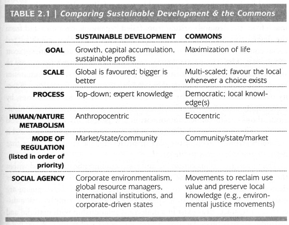
The authors argue for adopting a “commons”-based approach, where the term “commons” is understood to include not only the idea of commonly-held or shared rights and property (such as water, air, soil) but also the “social commons” comprised of community knowledge and culture. In stressing “the complex interrelations that exist at local, regional, national, continental, and global levels of human organization”, the authors critique advocates of “localism” and argue that “there can be no simple solution confined to one particular scale of action.”

A table in Chapter Two (Who cares about the Commons? by Josée Johnston) summarizes the key differences between sustainable development (as used by corporations and governments) and the commons-based approach favored by the book’s authors:

Table 2.1 of "Who cares about the Commons" by Josée Johnston.
Table 2.1 of “Who cares about the Commons” by Josée Johnston.

It is an example of this commons-based approach that Santiago Jiménez and Barkin examine in their chapter. They analyze an alternative, locally initiated project, based on the Integrated Development of Natural Resources (Administración Integral de los Recursos Naturales, AIRN), which stands in sharp contrast to Fonatur’s “top-down” development model. The AIRN approach recognizes that local communities have a symbiotic relationship with their surrounding natural environment that is “crucial for mutual survival”. It also recognizes that the community-environment links are dynamic, not static, and will change or evolve with time as the community develops.

AIRN proposals aim, essentially, to speed up this development process, helping to find new productive projects for the communities while managing ecosystems effectively and sustainably. The success of AIRN development projects relies on an active participation by the local community to identify issues, opportunities and ways to progress. It is crucial that the local people are equal partners in the decision-making process.

In the Huatulco area, the Center for Ecological Support (Centro de Suporte Ecológico, CSE), an NGO, adopted an AIRN approach to devise appropriate strategies to reverse the damage done to water resources by the construction and expansion of Huatulco tourist resort, which had destroyed forest cover, reduced infiltration and abstracted water from the aquifer that underlies the Copalita River. The CSE proposed a reforestation program to actively regenerate (not just protect) the forests throughout the basin, including parts of the Southern Sierra Madre (Sierra Madre del Sur). At the same time, the CSE helped local inhabitants to explore new (alternative) sources of employment and income based in their communities, which offered them a viable option to abandoning their land and accepting menial low-paid  jobs in the tourist resort or elsewhere.

Santiago Jiménez and Barkin looked at three small villages that had participated in the AIRN proposals made by the CSE: Santa María Xadani, Santa María Petatengo and El Achiote. Each village had participated in different ways, and with varying degrees of success. Close familial ties in Petatengo, for example, ensured more community support than in Xadani where internal divisions reduce social cohesion. El Achiote is a small “rancho” of 14 families, all of whom participated in the reforestation project. The families also combine to carve and paint the colorful Oaxacan whimsical wooden figures known as “alebrijes”. The settlement gained electricity service in 2000 and telephone service in 2001. Sadly, a combination of circumstances led to many local inhabitants migrating away from the area in search of better incomes and the CSE was forced to suspend its operations.

The authors point out that development plans have to take account of three very different concepts of time. The local communities in this region view time as somewhat flexible, preferring to make decisions by consensus, rather than in order to meet any deadline. Organizations providing funding for projects see time in terms of deadlines and financial commitments. Local and state governments view time in terms of political cycles, with a project having more chance of success if it is launched early on in an administration’s term. Santiago Jiménez and Barkin also emphasize the importance of projects having an effective mediator (as the CSE proved to be) “capable of balancing the rhythms of Western culture, of nature, and of traditional culture”.

Mexico badly needs more examples of successful mediators, particularly where large scale tourism projects are concerned.

Related posts:

Uxpanapa, an example of forced migration

 Excerpts from Geo-Mexico  Comments Off on Uxpanapa, an example of forced migration
Oct 312011
 

Almost all internal migration in Mexico in recent history has been voluntary. Tens of thousands of rural Mexicans have decided that life might be better somewhere else and have left their farms for the bright lights of the nearest large city. Their motivation is usually economic, but sometimes may be based on educational opportunities or access to health care.

However, not all internal migration has been voluntary. There have been some cases of forced migration, where the inhabitants of a village or area have been made to move away in order to make way for large-scale infrastructure projects such as reservoirs, tourism resorts and hotel complexes.

Since most good dam sites are in remote highland areas, with sparse population, forced migrations due to new dams are relatively rare in Mexico. One good example is when the building of the Cerro de Oro dam in the 1970s in northern Oaxaca, on a tributary of the River Papaloapan, flooded 360 square kilometers (140 square miles) and meant the forced relocation of more than 5000 Chinantec Indians. [Aguilera Reyes] The resettlement plan was one of the most forward-looking of its time. Villagers received compensation for their existing homes, trees and crops, and were offered a choice of possible resettlement sites.

They chose an area of rainforest-covered ridges and valleys near the headwaters of the Rivers Coatzacoalcos and Uxpanapa in the Isthmus of Tehuantepec. With government assistance they built a dozen new villages named, somewhat unimaginatively, Poblado Uno, Poblado Dos, etc. Extensive agricultural support was provided for several seasons, but the plan failed to live up to expectations, in part because its architect, the distinguished Mexican geographer Jorge Tamayo, was killed in a plane crash in 1978.

Many of the area’s young people have migrated (voluntarily) north. The remaining villagers grow ixtle, a fibrous cash crop produced from rainforest bromeliads that can be used for ropes and belts. They are also trying to introduce ecotourism to preserve what is left of their tropical jungle hideout, which has a rich biodiversity, including spider monkeys and jaguars. [Ginsberg]

References:

Aguilera Reyes, S. 2004 “Desarrollo, Población y Uso de los Recursos Naturales en el Valle de Uxpanapa.” Universidad Veracruzana Facultad de Sociología thesis. Xalapa,Veracruz. Marzo 2004.

Ginsberg, S. 2000 Report from Uxpanapa. Can bromeliads save Veracruz’s last rainforest? [6 September 2009]

Related posts:

This post is an edited excerpt from chapter 25 of Geo-Mexico: the geography and dynamics of modern Mexico. Buy your copy today!

Food speculation fuels a tortilla crisis in Mexico

 Books and resources, Teaching ideas  Comments Off on Food speculation fuels a tortilla crisis in Mexico
Oct 292011
 

The Ecologist Film Unit has produced an excellent 8-minute video on how financial speculation on corn (maize) has led to a dramatic rise in the price of corn tortillas, with potentially disastrous effects for the health and well-being of the many of Mexico’s poorest. Reporter Tom Levitt’s video, accompanied by text, presents a compelling case, one which would be an excellent starting-point for class discussions.

Two short quotes set the scene:

“For many Mexicans, particularly the estimated 40 million living on less than $5 a day (£3), tortillas account for almost half of their average daily calorie intake. As a whole, the country consumes 23 times more maize than rice.”

“In 2000 there was $6 billion invested in commodities, by 2011 it was $340 billion, of which $126 billion, according to data from Barclays Capital, is reported to be invested in food. The vast majority of this new investment has been by speculators with no interest in the agricultural sector or in actually taking delivery of the commodity.”

The result? Higher prices for corn, greater unpredictability in prices, and adverse changes to the diet of tens of thousands, as corn becomes more expensive than meager household budgets permit.

The video is a powerful indictment of the harm being done to ordinary people in many parts of the developing world by rich-world market speculators and investment banks. Watch it now, or read the full article:

Oct 222011
 

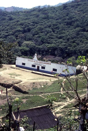
Mexico’s pioneering “telesecundaria” or “television secondary school” system began back in 1968. It now provides junior high school classes in remote areas, serving about one million students in grades 7 to 9, 17% of the total nationwide enrollment in these grades. Many of the telesecundaria lessons are now available on the Internet, and before long, about 4,500 classes will also be available on a DVD collection.

The geographical network of telesecundarias is truly amazing. In the early 1980s, I came across one high in the mountains in a distant corner of the state of Hidalgo, in a remote Huastec village, beyond even Coca Cola’s delivery routes. A visitor was such a surprise that the entire village turned out to inspect me!

Telesecundaria in Ixcatepec, Hidalgo

Telesecundaria in Ixcatepec, Hidalgo (1983) Photo: Tony Burton

It was that experience that made me realize that Mexicans take education very very seriously. The telesecundaria was perched on the hillside overlooking the village. I later discovered this was a fairly typical example, with three classrooms, rustic restrooms in an outhouse, and a small playground. Most telesecundarias also have a science laboratory and a small library.

The students in a telesecundaria do have a teacher, but this teacher teaches every subject, whereas in a regular junior high, each student will have up to twelve different subject specialists. Every telesecundaria classroom has a television set to receive lessons broadcast by the Education Ministry (SEP) in Mexico City.

Professional Programs

In the early days, lessons were very traditional, and the TV programs were little more than continuous shots of a “talking teacher”. Interestingly, almost all those early lessons were broadcast live. Nowadays, the entire process is much slicker and far more professional. The TV programs are 15 minutes long and feature all kinds of material, including animated graphics and video footage. Watching them, you are unlikely to see the “talking teacher” even for an instant! It takes about 20 days to produce each 15-minute module and costs up to 50,000 dollars. Most programs have a useful life of between five and ten years, depending on the timing of significant changes in subject content and teaching methods.

After students have seen the TV broadcast, the classroom teacher then uses the remaining 45 minutes of each hour to explain the lesson in more detail and to monitor students as they complete related tasks from their special telesecundaria textbooks.

Nationwide satellite transmission of programs began in 1994 (EDUSAT), enabling the coverage to spread far beyond those areas previously served by conventional TV stations. Programs are broadcast daily.

On-line samples

With the advent of the Internet, the telesecundarias are now being revamped as one part of SEP’s “On-line educational TV” (“Televisión educativa en línea“) project. That page has links to currently playing segments of material for various levels, including telesecundaria, and for teachers. (This is also a valuable resource for non-native speakers working to improve their Spanish and/or their knowledge of Mexico.)

Telesecundarias have proved to be an extraordinarily effective way of improving access to, and standards of, junior high education across Mexico. While the “costs of delivery” are estimated to be 16% higher in telesecundarias, on a per student basis, than in regular junior high schools, they are significantly cheaper on a per school basis. This means that some of the nation’s 13,000 or so telesecundarias can function cost-effectively even with only 10 or 12 students in each grade level.

The success of telesecundarias

Are telesecundarias successful? It certainly seems so. An estimated 79.4% of telesecundaria students complete grade 9, compared with an equivalent figure of 78.8% for regular junior highs. In addition, one study has shown that telesecundaria students may start Grade 7 significantly behind other students but generally catch up completely in math and reduce the deficit in language.

The program has been adopted by most Central American countries—Costa Rica, El Salvador, Guatemala, Honduras and Panama—and pilot projects are underway in the USA in California, Colorado, Pennsylvania, Oregon and Florida.

So next time you’re traveling in the wilds of Mexico or Central America, play “I spy” and see how many telesecundarias you can find. Bonus marks should be awarded for any that are outside the normal delivery range of Coca-Cola or Sabritas!

Update on Mexico and the UN Millennium Development Goals (MDGs)

 Mexico's geography in the Press, Updates to Geo-Mexico  Comments Off on Update on Mexico and the UN Millennium Development Goals (MDGs)
Sep 222011
 

In a previous post, we looked at Mexico and the UN Millennium Development Goals. This post is the text of a press release issued by the President’s Office in September 2011:

As part of the celebrations of the 50th Anniversary of the United Nations Development Program (UNDP), President Felipe Calderón gave the General Administrator of the Program, Helen Clark, Mexico’s report on the progress achieved in the Millennium Development Goals.

He highlighted the influence of UNDP in Mexico which, throughout its existence, has contributed to the alleviation of poverty and inequality, sustainable human development, the prevention of risks from natural disasters, the implementation of environmental policies and the promotion of democracy.

The main achievements highlighted by the president, regarding the fulfillment of the Millennium Goals, were: achieving universal coverage in primary education, eliminating the education gap between men and women, which eradicated the gender gap in education and increased female empowerment, improvements in the population’s living conditions, through the reduction of mortality and child malnutrition, the sustained increase in life expectancy and specialized care for expectant mothers, the expansion of access to the population’s health services, in which he declared that by the end of this year, universal coverage will be achieved, and the expansion of access to basic services such as safe drinking water, information technologies, communication and decent housing.

The main challenges to be met, said the president, were the alleviation of poverty, improvements in the per capita income and the reduction of the inequality gap. However, he also expressed confidence that they would be fully met in a timely fashion, since he confirmed the fact that the authorities are working continuously to achieve the universalization of pre-school and secondary education, improve the quality of education and improve the Human Development Index through successful programs such as Opportunities and the Popular Insurance Scheme.

The president ended by confirming his commitment to enabling Mexico to fully achieve the values, ideals and agenda set by UN in a timely fashion.

[This post is the text of a press release issued by the President’s Office in September 2011)

Less water available each year in Mexico as population increases

 Updates to Geo-Mexico  Comments Off on Less water available each year in Mexico as population increases
Jul 052011
 

Data from the National Statistics Institute (INEGI) show that Mexico’s available water has fallen to 4,263 cubic meters/person/year. Water availability depends on the amount of rainfall received each year and on total population. Mexico’s water availability has declined rapidly since 1950, when it was 18,053 cubic meters/person/year. Of 177 countries analyzed by the Food and Agriculture Organization (FAO), Mexico ranked 90th in terms of water availability.

According to INEGI, Mexico’s total current demand for water nationwide is 78.4 billion cubic meters/year, 11.5 billion more than natural replenishment rates. The drainage basins facing the most severe shortfalls are the Lerma basin in central Mexico, and the Río Grande in northern Mexico.

On the positive side, Mexico reached its UN Millennium Development Goal target for access to water 10 years early, by reducing the percentage of population without access to water in their homes from 25% in 1990 to less than 8% in 2010.

Mexico has also already met its target for improving access to wastewater drainage, where the proportion of the population lacking access to sewage systems has fallen from 37% in 1990 to 10% in 2010.

Mexico’s water resources and water-related issues are the subject of chapters 6 and 7 of Geo-Mexico: the geography and dynamics of modern Mexico. Ask your library to buy a copy of this handy reference guide to all aspects of Mexico’s geography today! Better yet, order your own copy…


Key geographic indicators from Mexico’s 2010 Census

 Updates to Geo-Mexico  Comments Off on Key geographic indicators from Mexico’s 2010 Census
Jun 202011
 

This post summarizes some important characteristics of Mexico’s population and households, as revealed by the definitive results of the 2010 population census.

Literacy

5.3 million Mexicans over the age of 15 are unable to read and write a simple message (i.e. they are functionally illiterate). The highest rates of illiteracy are in Chiapas (17.0%), Guerrero (16.7%) and Oaxaca (16.3%), with the lowest rates in Mexico City (2.1%), Nuevo León (2.2%) and Baja California and Coahuila (both 2.6%).

Average Age

The average age of Mexico’s population has risen from 22 years in 2000 to 26 years in 2010. In 2010, 29% of the population was under the age of 15 (compared to 34% in 2000) and 6.3% was in the 65+ age group (compared to 5.0% in 2000).

Dependency ratios

The dependency ratio of a population is worked out by comparing the number of people of working age (normally taken to be 15-64 years old) with the number of young people (under age 15) and elderly (65+ years old). The dependency ratio has shifted from 64 dependents in every 100 people (64/100) in 2000 to 55/100 in 2010. More significantly, of the 64 dependents in 2000, 56 were children and 8 were elderly, whereas of the 55 in 2010, 45 were children and 10 were elderly. This is a clear shift towards an “elderly-dependent” population.

Fertility and education

The 2010 census shows that women of child-bearing age (15-49) have had an average of 1.7 children each, compared to 2.0 children in 2000. The averages mask enormous differences in rates. For example, women with a senior high school (preparatoria) education have 1.1 children on average, compared with 2.5 children for women who only completed secondary school, 3.3 children for those who completed primary education, and 3.5 children for those without any formal education.

Household possessions

Almost all (93%) of Mexico’s 35.6 million households have at least one TV, 82.1% have refrigerators, 65% cell phones, 45% have a vehicle, 43% a fixed telephone line, 29% a computer, and 21% have Internet access.

Are Mexicans the world’s hardest-working people or the least productive?

 Books and resources  Comments Off on Are Mexicans the world’s hardest-working people or the least productive?
Jun 042011
 

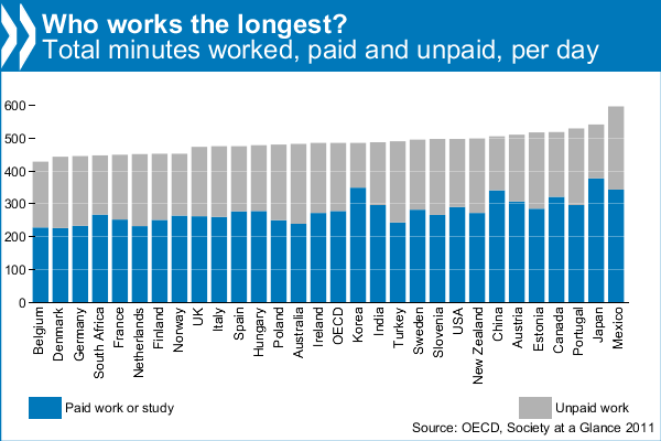
The headline — “Mexicans work longer hours than anyone else” — said it all, or did it? A recent report from the OECD (Organisation for Economic Co-operation and Development) found that Mexicans worked longer hours than people in any other OECD country, devoting 10 hours a day to paid and unpaid work (the latter includes housework and cooking). By contrast, Belgians work the least, only 7 hours. The OECD average is 8 hours a day. Is the positive spin simply because the OECD is currently headed by Mexican economist Dr. Angel Gurría?

The figures come from the latest edition of OECD’s Society at a Glance (2011), which gives an overview of social trends and policy developments in all member countries. Using indicators taken from OECD databases and other sources, it shows how societies are changing over time and how different countries compare.

Most unpaid work is housework. Mexicans do the most, more than 3 hours per day, and Koreans the least, only 79 minutes. Mexicans spend more time cooking than is customary in most other countries. The inhabitants of the USA spend the least time cooking each day, barely 30 minutes, and Turks the most, 74 minutes. Most people spend around 50 minutes a day cooking. Shopping also makes up a big part of unpaid work. The OECD average is 23 minutes a day, with the French spending the most (32 minutes) and the Koreans the least (13 minutes).

OECD: Working Hours

OECD: Working Hours

The report also attempts to estimate how much unpaid work is worth as a percentage of GDP for the 25 OECD countries for which data are available. It finds that the value of unpaid work is considerable, equivalent to about one-third of GDP in OECD countries, ranging from a low of 19% in Korea to a high of 53% in Portugal.

From a Mexican perspective, this may all paint a very rosy picture. However, as other commentators (see, for example, Burro Hall) have pointed out, it could equally well mean that Mexicans have the lowest productivity in the world, since they are working longer hours than other countries, but failing, in most sectors, to out-perform them!

Other highlights from the OECD’s Society at a Glance:

  • The 4 hours and 21 minute difference in unpaid work time between Mexican women and men is the largest in the OECD, where the average gap is 2 hours and 28 minutes
  • Mexicans have the second highest level of income inequality and the highest level of relative poverty in the OECD. One in every five Mexicans are poor, compared to just above one in ten on average across the OECD. Nearly half of Mexicans find it difficult or very difficult to get by on their current income.
  • Mexicans report the third highest positive psychological experiences (feeling rested, smiling, learning, and enjoyment) and lower than average negative experiences (pain, worry, stress, sadness, depression).

Make your own “Better Life Index”

 Books and resources, Teaching ideas  Comments Off on Make your own “Better Life Index”
May 252011
 

An interactive graph from the OECD (Organisation for Economic Co-operation and Development) now allows you to compile your own “Better Life Index” and compare “well-being” across the 34 member countries of the OECD. From an educational perspective, the graph offers hours of fun and fact-filled learning opportunities.

Better Life Index

The graph allows you to set individual weightings for each of 11 variables considered by the OECD to be important for well-being, and then see how the 34 countries rank on a graph. The graphs can be arranged either by rank or by country name. The 11 variables are:

  • housing
  • income
  • jobs
  • community
  • education
  • environment
  • governance
  • health
  • life satisfaction
  • safety
  • work-life balance

The symbols for each country are a flowers with 11 petals, one for each variable, where the length of the petal represents that country’s score and the width of the petal reflects the weighting you’ve given it.

This would be a great starting point for discussions of what “well-being” really means, and why different people (different countries?) would choose very different weightings for the 11 variables.

Related posts:

Various simple and compound development indices are discussed in chapters 29 and 30 of Geo-Mexico: the geography and dynamics of modern Mexico. Ask your local library to purchase a copy today!

Are Mexican females overtaking males in literacy?

 Updates to Geo-Mexico  Comments Off on Are Mexican females overtaking males in literacy?
May 142011
 

For at least the last century, literacy for Mexican males has been significantly higher than that for females. According to the 2010 census 93.7% of Mexican males aged 15 and over were literate compared to only 91.1% of females. Males have higher literacy levels in all 32 Mexican states except for Sinaloa (males – 94.1%, females – 94.7%) and Sonora (males – 96.2% and females – 96.3%). We introduced the spatial aspects of literacy in Mexico in an earlier post:

The greatest gaps between literacy among males and females are in states with relatively low literacy levels (Pearson correlation = 0.89). For example, in Chiapas male literacy is 86.0% while that for females is only 77.5% for a difference of 8.5%. Other states with large gaps are Oaxaca (87.3% – 79.4%, gap of 7.9%), Guerrero (85.4% – 79.8%, gap of 5.6%), and Puebla (91.7% – 86.8%, gap of 4.9%). The data suggest that as literacy levels in states increase, the gap between males and females should decline.

Will the gap between male and female literacy levels decline in the decades ahead? Date from the 2010 census indicates that both illiteracy rates and the gap between males and females are far greater for older Mexicans. For those over age 75, male literacy is 71.2% while that for females is only 62.3% resulting in a gap of 8.9%. The gap is 8.4% for those between 60 and 74 years of age (83.3% versus 74.9%) and 4.4% for the 45 – 59 age group (93.1 versus 88.7%). The gap for those between 30 and 44 years of age is only 1.1% (96.4% versus 95.3%) and for the 15 to 29 age group, males and females are equal at 98.1%.

Does this trend suggest that female literacy will surpass male literacy in the future? The answer to this question appears to be yes. Data from the 2010 census on children between ages six and 15 indicates female literacy (87.32%) is already 1.33% higher than male literacy (85.98%). These levels seem rather low because literacy levels for children below age ten, particularly males, are generally lower. For example, among children age seven, literacy for females is 3.06% higher than that for males (73.91% versus 70.85%). That nearly 30% of seven-year-olds are illiterate suggests a problem; but most of these will become literate by age 15. Among children between age 14 and 15, female literacy is 98.40% compared to 98.09% for males.

The census provides data on the literacy of children for each age between age six and 15 for all 32 Mexican states. Literacy rates for female children are higher than those for males in all 288 observations (9 age groups times 32 states), expect for five (ages 11, 12, 13 & 14 in Chiapas and age 12 in Tlaxcala).

The largest gap between females and males is 4.6% for six-year-olds in Zacatecas (females – 43.51%, males – 38.91%). Other large gaps exist for seven-year-olds in Zacatecas (4.41%), six-year-olds in Querétaro (4.37%), seven-year-olds in Tamaulipas (4.34%), and seven-year-olds in Tabasco (4.33%). These findings are consistent with other evidence indicating that females develop language skills at younger ages than males. The data clearly indicate that female literacy is surpassing male literacy. Perhaps more importantly, both males and females are now approaching universal literacy.

We assume that the literacy gap between female and male children will continue in future decades. After a decade or two, we expect adult literacy rates for females to catch and surpass those for males. On the other hand, this gap will be very small because Mexico is quickly approaching universal literacy. When data become available we will analyze the gap in total years of education between females and males. We expect the situation in Mexico to move slowly towards the pattern in the USA, where females now have more years of education and more university degrees than males.

Literacy rates are, of course, only one of the many aspects of gender inequality in Mexico.

Are the residents of Ciudad Nezahualcóyotl becoming middle class?

 Mexico's geography in the Press  Comments Off on Are the residents of Ciudad Nezahualcóyotl becoming middle class?
Feb 062011
 

In a previous post –Nezahualcoyotl, an irregular settlement which grew into a monster – we looked at the extraordinarily rapid growth of Ciudad Nezahualcóyotl (today a city of over 1.5 million inhabitants) from its start on the dried-up lake bed east of Mexico City in the 1950s.

Nezahualcoyotl, the city of dreams

Nezahualcoyotl, the city of dreams, now has its own Sears and Wal-Mart

The Economist special report on Latin America (11 September 2010) included an evocative description of Ciudad Nezahualcóyotl, well worth reading. It describes how “an impoverished settlement of dirt streets and one-storey shacks built of grey concrete blocks” [ed: see photo] has become “comfortable homes of two or three storeys” with asphalted streets and “traffic-clogged thoroughfares… lined with businesses of every type”. Next to a Wal-Mart and private hospital is a shopping center with Sears and C&A, boutiques and a multiplex cinema.

The inhabitants aspirations have changed from bicycles to private cars, and include hopes of a higher education and finding a well-paid position elsewhere. The article concludes that the rise in living standards of many of the people is (arguably) creating  a “middle class” society, before examining the concept of “middle class” in much more depth.

How did Mexico rank on the 2010 Legatum Prosperity Index?

 Other  Comments Off on How did Mexico rank on the 2010 Legatum Prosperity Index?
Jan 122011
 

Mexico scored relatively poorly in the 2010 Legatum Prosperity Index. It occupied rank 53 of the 110 countries for which sufficient data was available. The Prosperity Index compares data for dozens of criteria, grouped for convenience into seven main categories. These categories, with some examples of their respective criteria) are:

  • Economy (GDP, employment indices, optimism about the economy, ability to afford food and shelter, inflation, savings rates, rate of non-performing bank loans)
  • Entrepreneurship and Opportunity (royalty receipts from intellectual property, ICT exports, R&D expenditure, cell phone ownership, business start-up costs)
  • Governance (political system, business regulations, effectiveness of government bureaucracy, anti-poverty policies, environmental policies, confidence in legal system, fairness of elections)
  • Education (enrolment in primary, secondary and tertiary education, gender equality in education, class sizes, years of schooling)
  • Health (rates of malnourishment, immunization, infant mortality, perception of personal health, life expectancy, healthcare budget)
  • Safety and Security (refugees, internally displaced persons, incidence of state-sponsored violence, disputes over ownership or occupancy of land, control of religious or historical sites, proximity to environmental hazards, crime rates)
  • Personal Freedom (freedom of speech and belief, civil liberties, racial tolerance)
  • Social Capital (religion, perceived trustworthiness, voluntary work, charitable donations)

prosperity-index

How does Mexico compare to other countries in the Americas?

The top ten countries in the Americas on the Prosperity Index, together with their world rank, are:

  • Canada 7
  • USA 10
  • Chile 32
  • Uruguay 28
  • Costa Rica 33
  • Panama 40
  • Argentina 41
  • Trinidad and Tobago 44
  • Brazil 45
  • Mexico 53

How does the Prosperity Index summarize Mexico’s position for the different groups of critera?

  • Economy (rank 31) – Mexico has a large and relatively stable economy, but some citizens struggle to afford life’s necessities.
  • Entrepreneurship and Opportunity (rank 59) – Bureaucracy and poor technological infrastructure limit entrepreneurial and innovative activity in Mexico.
  • Governance (rank 66) – Mexico’s government may be unpopular, but it is largely democratic and well regulated.
  • Education (rank 69) – Mexico successfully promotes basic education, but does not produce enough skilled workers.
  • Heath (rank 54) – Mexicans receive good preventative healthcare and are broadly satisfied with their health.
  • Safety and Security (rank 79) – Mexico suffers serious challenges from criminal violence and emigration.
  • Personal Freedom (rank 72) – Mexicans are relatively dissatisfied with their own lives and relatively intolerant of immigrants.
  • Social Capital (rank 39) – Mexican social networks are strengthened by volunteer work and religious attendance.

Various simple and compound development indices are discussed in chapters 29 and 30 of Geo-Mexico: the geography and dynamics of modern Mexico. Ask your local library to purchase a copy today!

Dec 122010
 

The map below shows the average number of inhabitants per household (“household size”) for each of Mexico’s states.

The national average household size is 3.9 persons. The middle band on the map shows those states with household size between 3.7 and 4.0 inclusive. The darkest shade shows states with a household size of 4.1 or greater; the lightest shade shows those with a household size of 3.6 or smaller.

Average household size in Mexico, 2010

Average household size in Mexico, 2010. Cartography: Tony Burton; all rights reserved.

Discussion questions:

  • Compare this map with the maps of:
  1. potable water,
  2. GDP/person
  3. infant mortality
  • Discuss the possible reasons for any connections you note between household size, potable water, GDP/person and infant mortality.
  • What other factors might also affect household sizes?
  • What are the drawbacks to using any of these measures (household size, potable water, GDP/person, infant mortality) on their own as a development indicator?

Development indices of various kinds are discussed in chapters 29 and 30 of Geo-Mexico: the geography and dynamics of modern Mexico. Ask your local library to purchase a copy today!

Dec 102010
 

Mexico’s economy, the world’s 11th largest, is growing rapidly and predicted by many analysts to become the world’s fifth largest by 2050. It is not, therefore, surprising that, according to a recent report on key emerging markets from Spanish bank BBVA, investments in emerging markets are assuming more and more importance. However, the all-encompassing term “emerging market” covers a multitude of countries whose individual economies are incredibly diverse. It includes not only major economies such as those of China, India and Mexico, but also a host of tiny island states such as Grenada, Vanuatu and the Seychelles.

BRICs or EAGLE

BRICs or EAGLE?

Economists have suggested various sub-groupings of emerging markets. One of the most commonly used in geography is BRIC, an acronym formed from the initial letters of Brazil, Russia, India and China. The term BRIC was first coined by  Jim O’Neill in a 2001 paper entitled “The World Needs Better Economic BRICs”. The concept of BRICs has become outdated as the four countries’ economies have diverged over the past decade. Any term comprised of country names will inevitably date fairly quickly, and become much less useful.

Now, BBVA has proposed the use of the term EAGLE to cover the world’s Emerging and Growth-Leading Economies. The member states of this exclusive EAGLEs club are:

  • China
  • India
  • Brazil
  • Russia
  • South Korea
  • Indonesia
  • Mexico
  • Turkey
  • Eqypt
  • Taiwan

These ten countries are each expected to contribute more to global economic growth than the average of G7 members. Combined, the ten EAGLEs are  expected to account for 50% of all global growth in the next 10 years.

A further eleven countries—Nigeria, Poland, South Africa, Thailand, Colombia, Vietnam, Bangladesh, Malaysia, Argentina, Peru and the Philippines—are identified by BBVA as having the potential to join the EAGLEs if their economies grow more than expected.

The BRIC is dead! The EAGLEs are rising! Long live the EAGLEs!

Mexico’s economy and workforce are analyzed in chapters 14 to 20 of Geo-Mexico: the geography and dynamics of modern Mexico. Ask your library to buy a copy of this handy reference guide to all aspects of Mexico’s geography today! Better yet, order your own copy…

Where in Mexico do people still lack access to potable water?

 Maps, Teaching ideas  Comments Off on Where in Mexico do people still lack access to potable water?
Nov 162010
 

The map shows the 14 states in Mexico where less than 90% of the population has potable water in their homes.

map of potable water in Mexico

The 14 states with poorest potable water access in Mexico

How does the distribution of state with relatively poor access to potable water compare with maps of:

Development indices of various kinds are discussed in chapters 29 and 30 of Geo-Mexico: the geography and dynamics of modern Mexico. Ask your local library to purchase a copy today!