Geography, residence patterns and architecture in the mining town of Santa Rosalía, Baja California Sur

 Other  Comments Off on Geography, residence patterns and architecture in the mining town of Santa Rosalía, Baja California Sur
Mar 092017
 

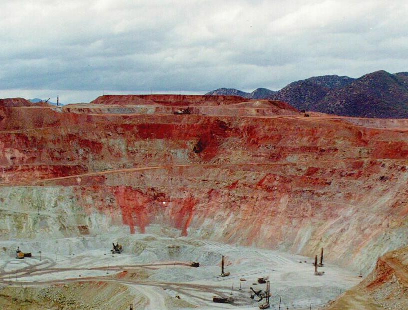
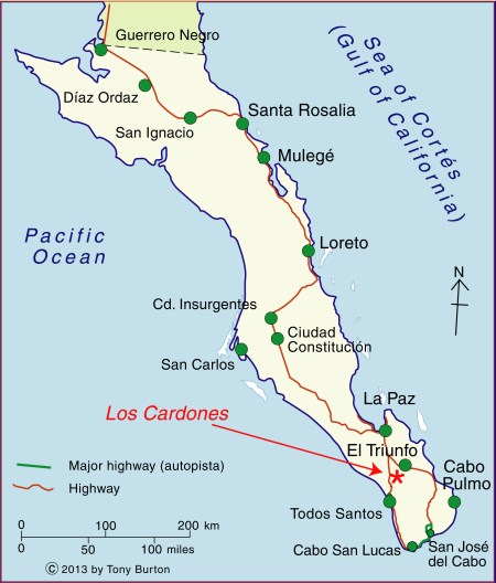
In a previous post — The re-opening of the giant El Boleo copper mine in Santa Rosalía, Baja California Sur —  we looked at the repeated boom-bust-boom history of the copper mining center of Santa Rosalía on the Baja California Peninsula. The arid peninsula did not offer much in the way of local resources for the construction of a mining settlement. When mining took off, an entire town was needed, virtually overnight. Almost all the materials necessary for the construction and exploitation of the mines and for building the houses and public buildings had to be imported, primarily from the USA.

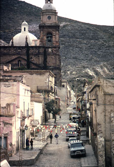
As the town grew at the end of the nineteenth century, a clear geographic (spatial) segregation developed, which is still noticeable even today:

  • Workers’ homes were built on the lowland near the foundry and port
  • Higher up the slope was the Mexican quarter where government workers and ancillary support staff lived
  • The highest section of town, overlooking everything, was the French quarter.

The contrasts of Santa Rosalía at this time were well summed by María Eugenia B. de Novelo:

“Santa Rosalía was a place of clashing contrasts and situations. It had a scarred backdrop of copper hills, a black-tinted shore, French silks, fine perfumes, crystal, Bordeaux wines and Duret cooking oil, sharing the scene with flour tortillas, giant lobsters, abalone and chimney dust.”

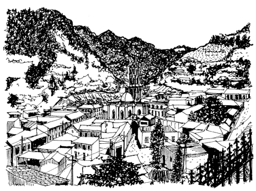
The French quarter has retained its distinctive architecture to the present day. At one end is the Hotel Francés, opened in 1886, which has an incredibly stylish period interior and still operates today.

Hotel Francés, Santa Rosalía

Hotel Francés, Santa Rosalía. Photo: Tony Burton

The gorgeous architecture of many of the homes of the French quarter is reminiscent of New Orleans. Beautiful wooden houses stand aloof on blocks with porches, balconies and verandas, competing for the best view over the town below. Wooden homes are decidedly unusual in this part of Mexico, which was never forested, and are, indeed, rare almost everywhere in the country. There are so many wooden homes here that Santa Rosalía has long had its own fire department, just in case!

At the other end of the French quarter are the former mining offices, now the Museo Boléo, an interesting museum where interior details are little changed from a century ago. Standing in the main hall, it is possible to imagine the hustle and bustle of former days, as clerks work feverishly to keep up with their superiors’ numerous demands. The mining company attracted workers from far afield. Three thousand Chinese workers arrived, settling the districts still known as La Chinita and Nuevo Pekin.

The most conspicuous landmark in the main part of town remains the former foundry, no longer open to the public. The next most conspicuous landmark is the church of Santa Bárbara. There are serious doubts as to who designed this unusual church, assembled out of pre-fabricated, stamped steel sheets or plates. Most guidebooks attribute the church to Gustave Eiffel, the famous French architect responsible for the Eiffel Town in Paris. According to this version, Eiffel’s design won a prize at the 1889 Universal Exposition of Paris, France, and was originally destined for somewhere in Africa. It was later discovered in Belgium by an official of the Boleo mining company, who purchased it and brought it back to Santa Rosalía in 1897.

The church of Santa Rosalía

The church of Santa Rosalía. Photo: Tony Burton.

The latter part of the story may be correct, but research by Angela Gardner (see Fagrell, 1995) strongly suggests that the original designer was probably not Eiffel but is far more likely to have been a Brazilian, Bibiano Duclos, who graduated from the same academy as Eiffel in Paris. Duclos took out a patent on pre-fabricated buildings, whereas there is no evidence that Eiffel ever designed a pre-fabricated building of any kind. Whoever designed it, it is certainly a unique design in the context of Mexico, and well worth seeing.

Other well-preserved buildings dating back to the heyday of the town’s success include the municipal palace or town hall (formerly a school designed by Gustave Eiffel), the Central Hotel, the DIF building, the Club Mutualista, the Post Office and the Mahatma Gandhi library, currently being restored. The library is in Parque Morelos, which is also the last resting place for a Baldwin locomotive dating back to 1886.

If walking around town looking at the architecture makes you hungry, try the French pastries (and Mexican sweet breads) from the Panadería El Boleo on the main street. With slight hyperbole, Panadería El Boleo boasts on its wall of being the World’s most famous bakery. Expect to queue, but enjoy the smells of fresh baked goods while you wait.

The distinctive history, architecture (and pastries) of Santa Rosalía, assuming they are conserved, should prove in the future to be an excellent basis for the development of cultural tourism to supplement the ecotourism and adventure tourism already in place.

Sources:

Want to read more?

Note : This post was first published 11 October 2011.

The world’s largest crystals and strange microbes grow in caves in Chihuahua, Mexico

 Excerpts from Geo-Mexico, Updates to Geo-Mexico  Comments Off on The world’s largest crystals and strange microbes grow in caves in Chihuahua, Mexico
Feb 182017
 

The Naica caves, in the northern state of Chihuahua are home to the world’s largest natural crystals. The crystals are selenite, said to enhance sex drive.

The formation of the crystals caves is described in more detail below, but in February 2017, Penelope Boston, head of Nasa’s Astrobiology Institute announced that “bizarre and ancient microbes” had been found in these caves. The discovery came after nine years of work and was first announced at the American Association for the Advancement of Science conference in Boston. The life forms in the Naica caves survive by living on minerals such as iron and manganese and could be 50,000 years old. The find is still subject to peer-review and independent confirmation:

How were the crystals discovered?

Early in 2001, news emerged of a truly extraordinary discovery in caverns deep under the earth in the state of Chihuahua. Miners tunneling through the Naica Hills, south of Chihuahua City, in search of silver and zinc, found huge mineral crystals, far larger than any natural crystals previously seen anywhere else on the planet.

Massive crystals in Naica Cave, Chihuahua

Massive crystals in Naica Cave, Chihuahua. Photo credit: Speleoresearch Archive and Films La Venta

The monster crystals, over six meters long, are made of selenite, a crystalline form of the mineral gypsum (the number one ingredient in blackboard chalk!). For its pale translucence, this form of gypsum is known as selenite, named after Selene, the Greek goddess of the moon.

The largest crystals are over 11 meters long, and weigh more than 55 tons. Scientists believe they have found DNA from ancient bacterial life trapped in air bubbles inside the crystals.

The crystals formed when the caverns were completely filled with hot water (warmer than 50 degrees C) supersaturated with calcium sulphate (gypsum) for very long periods of time. The estimated growth rate, confirmed by uranium-thorium dating, is 1.5 mm per 1000 years, which means that the longest crystals took more than 500,000 years to form.

The engineer working for the mining company Peñoles that first reported these caves believes that many more caves probably exist, but stresses that they would never have been located at all if it had not been for the mine’s massive pumps (pumping more than 16,000 gallons of water out each minute) working round the clock for years. This pumping has lowered the water table from 100 meters below the surface to about 300 meters in the area of the mines. Since the caverns have been drained, the crystals are no longer growing, and the temperatures in the cavern have fallen by about 0.5 degrees C each year.

The Naica (“shady place”) hills have been actively mined for more than a century. Even though early prospectors discovered silver here in 1794, the first formal mining claim was not made until a century later in 1896, by one Santiago Stoppelli, and large scale mining only began in 1900.

Ten years later, super-large sword-shaped crystals of selenite were found in a cavern at a depth of 120 meters. Over the years, a steady stream of geologists and mineral collectors have visited this 70-meter-diameter cave, since renamed the Cave of the Swords, which is now equipped with paths, lights and a ventilation system. Even with this system, the temperature in the cave is a stifling 40 degrees C! Several typical examples of selenite crystals from this cave, ranging in length from 1.2 to 1.6 meters (4 to 4.25 feet), are displayed in the Smithsonian’s National Museum of Natural History.

But these specimens from the Cave of the Swords are small fry in size when compared with the latest discoveries, 300 meters below the surface, in the Cave of the Crystals. In two relatively small chambers, each the size of a small apartment, miners found incredibly large selenite crystals, some over six meters long. The crystals combine to form massive fifteen-meter-long columns, “the size of pine trees”, as well as hundreds of formations shaped like sharks’ teeth, jutting about a meter up from the cave floor. The overall effect is, in the words of Richard Fisher, an Arizona-based photographer and adventurer, like walking into an enormous geode.

The Future

Mining operations at Naica have been in the hands of the Peñoles group since 1961 and the mine, one of the most productive in Chihuahua, still produces ample quantities of lead, silver and zinc.

Even if the silver ore is eventually worked out, Peñoles realizes that the caverns might have a very bright future as a major geo-tourist attraction. The company has not only taken steps to safeguard the crystals, but was already developing a tourism plan, which involved the installation of an air-conditioning system in the caverns, since the temperature in the Cave of Crystals is a mind-boggling 60 degrees Celsius. This heat, combined with the 100% humidity in the caverns, is so suffocating and disorienting that researchers can only safely spend a few minutes at a time studying this fantastic sight.

The harsh conditions have not deterred crystal looters who are already reported to be breaking through padlocked doors and trying to chisel prize specimens off the cave walls. This is a dangerous business and the effort proved fatal for one would-be collector when the gigantic crystal he was attempted to sever broke away from the ceiling and crushed him as it fell. The combined physical forces of Newton and Darwin caused this particular plunderer to meet his maker!

It was announced in October 2015 that Peñoles had been forced to close its Naica mine indefinitely, following its failure to reduce the level of water in the mine following a flood in January 2015. The company was seeking to redeploy more than 400 workers. In 2014, the Naica mine produced 19,694 tons of lead, 15,399 tons of zinc and 1.9 million ounces of silver (25% 6% and 3% respectively of the company’s total output of each metal).

Whether or not attempts will be made in the future to allow access to view the crystals is unknown. It is perfectly possible that other miners in the region might be lucky enough to find even bigger crystals nearby!

These cavers may never be suitable for sustainable tourism. To preserve these magnificent crystals for future generations, the decision may have to be taken to leave the caverns under water, protecting the crystals that already exist and allowing new ones to grow.

These amazing crystals are one of the latest additions to the incredible list of natural wonders that can be enjoyed in Mexico!

For truly amazing images of the crystals, watch the Discovery Channel documentary “Naica: Secrets of The Crystal Cave” (2008).

Note:

  • This is an update of a post originally published in 2010

Mexico’s geology, relief and landforms are analyzed in chapters 2 and 3 of Geo-Mexico: the geography and dynamics of modern Mexico. Buy your copy of this invaluable reference guide today!

Jun 202016
 

Mexico is the world’s leading producer of silver and has occupied top spot for several years. Mexico’s output of silver rose 2.0% in 2015 to 5,372 metric tons (189.5 million ounces). Mexico is responsible for 21% of global production, followed by Peru (15%), China (12%) and Australia and Russia (each 6%). About 70% of silver produced in Mexico is exported, the remainder is sold on the domestic market.

Global silver production fell slightly in 2015 due to decreased output from Canada, Australia and China. World demand for silver in 2015 reached a record 33,170 tons (1,170 million ounces), due to surges in three manufacturing sectors: jewelry, ingots and coins, and photo-voltaic solar panels.

The increased output in Mexico came from expansions in the Saucito and Saucito II mines, operated by Fresnillo, and the El Cubo mine, managed by Canadian firm, Endeavour Silver. A similar increase in production is predicted this year, given the on-going expansion of the San José mine, owned by Canada-based Fortuna Silver Mines.

Zacatecas is Mexico’s leading silver producing state (46.5% of total; see map), well ahead of Chihuahua (16.6%), Durango (11.3%) and Sonora (6.9%).

Silver production in Mexico, 2011. Data: INEGI. Credit: Tony Burton/Geo-Mexico

Silver production in Mexico, 2011. Data: INEGI. Credit: Tony Burton/Geo-Mexico

In Zacatecas, silver mining is especially important in the municipalities of Fresnillo (24% of total national silver production) and Mazapil (15%) as well as Chalchihuites and Sombrerete (3% each). The main silver mining municipality in Chihuahua is Santa Bárbara (3% of national total). In Durango, San Dimas and Guanaceví are each responsible for about 3% of national production, while the leading municipality for silver in Sonora is Nacozari de García (1%).

The legacy of silver

The importance of silver mining in colonial New Spain can not be over-emphasized. For instance, during colonial times nearly one third of all the silver mined in the world came from the Guanajuato region!

Even today, the cities and landscapes of many parts of central and northern Mexico reveal the historical significance of silver mining. The legacies of silver mining include not only the opulent colonial buildings in numerous major cities such as Zacatecas and Guanajuato, as well as innumerable smaller towns, but also the deforestation of huge swathes of countryside.

The landscape of states like San Luis Potosí, Zacatecas and Guanajuato was forever changed by the frenzied exploitation of their woodlands. Silver mines needed wooden ladders and pit props. The smelting of silver ore required vast quantities of firewood. Barren tracts of upland testify to the success of those early silver mines. Mining played a crucial role in the pattern of settlement and communications of most of northern Mexico. The need to transfer valuable silver bullion safely from mine to mint required the construction of faster and shorter routes (see, for example, El Camino Real or Royal Road, the spine of the colonial road system in New Spain), helping to focus the pattern of road and rail communications on a limited number of major cities.

Once workable ores ran out, smaller mining communities fell into obscurity and many became ghost towns. Some of these settlements, such as Real de Catorce and Angangueo, have enjoyed a new lease of life in recent years due to tourism.

The main town associated with silver and tourism is Taxco, the center of silversmiths and silver working in Mexico.

Mining towns described briefly previously on Geo-Mexico.com include:

Note: This is a 2016 update of a post first published in 2013.

Related posts:

Grupo México plans to mine copper in Monarch Butterfly reserve

 Mexico's geography in the Press  Comments Off on Grupo México plans to mine copper in Monarch Butterfly reserve
May 262016
 

Mexico’s largest mining company, Grupo México plans to mine copper from its mine in Angangueo, Michoacán, according to the town’s mayor, Leonel Martínez Maya, who says it would revitalize the local economy. Large-scale mining in the town declined after a serious accident in 1953, said to have been attributable to the company’s then-foreign management in response to a threatened strike. The miners who lost their lives in this accident are commemorated by a huge statue which overlooks the town.

Angangueo. Sketch by Mark Eager; all rights reserved.

Angangueo. Sketch by Mark Eager; all rights reserved.

The mayor is adamant that the renewal of active mining in the town would have no adverse consequences for the annual migration of Monarch butterflies (who overwinter in their tens of millions in the pine-fir forests above the town)  or on their habitat.

The town is one of Mexico’s “Magic Towns” and the area is a protected natural reserve, but apparently the mining company is taking advantage of a legal loophole and arguing that the mine predates the establishment of the Monarch reserve, and that the mine was never technically closed, even though it was inactive in recent years. The Michoacán state government is said to support the Grupo México initiative.

Despite boom times in the past, the town of Angangueo currently has only limited sources of revenue other than seasonal tourism.

The illustration and parts of the description come from chapter 30 of my Western Mexico, a Traveller’s Treasury (4th edition, 2013).

Related posts:

Feb 122015
 

The largest salt-making facility on the planet is near Guerrero Negro on the west coast of Mexico’s Baja California Peninsula. It produces about 9 million metric tons of salt each year. The salt here is not mined, but extracted from ocean water by evaporation. The salt fields cover 33,000 hectares (acres), including 28,000 ha of collection ponds and 3,000 ha of crystallization ponds.

Satellite image of part of Guerrero Negro saltworks

Satellite image of part of Guerrero Negro saltworks

The major locational advantages are:

  • the large flat area close to the coast, a former marine floor
  • the dry climate; this is a desert region with very low precipitation
  • the high solar radiation (direct solar powered evaporation!)
  • regular strong winds blowing from the Pacific Ocean
  • the net result of the climate is a high evaporation index

Disadvantage? Since the salt working got underway around the saline Ojo de Liebre coastal lagoon, the entire area has been designated part of the El Vizcaino Biosphere Reserve on account of its importance as a habitat for endangered species and breeding ground for gray whales. The salt lagoons are also located on major flight paths for migratory birds.

Brief history of salt-making in Guerrero Negro

Prior to the 1950s, salt extraction in this area was small-scale and methods were rudimentary. In the 1950s, San Francisco ceased supplying salt to the US west coast paper industry and an alternative source of salt was needed. Daniel Ludwig (who would later build the famed Acapulco Princess Hotel) set up a company at the saline Ojo de Liebre coastal lagoon near Guerrero Negro in 1954; three years later, salt was exported to the USA for the first time. Ludwig sold the company in 1973. Exportadora de Sal (Salt Exporter) is now jointly owned by the Mexican government (51%) and the Japanese Mitsubishi corporation (49%).

Plans to expand the company by building another evaporation plant for salt further south along the Baja California Sur coast were thwarted by officials after a lengthy and acrimonious campaign by environmentalists angered at the probably environmental consequences. (For discussion of some of the issues, see “Mitsubishi and Laguna San Ignacio“, “Mexico’s Friendly Whales” and “The Laguna San Ignacio Conservation Alliance conservation plan“).

What does the landscape look like?

This short, 3-minute Postandfly video shows what the landscape and salt working operations look like from the air:

The salt-making process

The salt-making process is fairly simple. Seawater is pumped into a series of collection ponds. About 700 million tons of seawater enters the system each year. As the water in the ponds evaporates, the salt concentration increases. The collection ponds are controlled by dikes and gates. At a critical level of salt concentration, the water is pumped into the next point, and so on.

Salt trucksEventually, more than a year later, the water becomes saturated with salt, and the mineral salt (almost entirely sodium chloride) begins to crystallize out. The pond is then drained and the salt collected. The harvesting of the salt is done by giant graders which scrape off only the uppermost layer, leaving a hard saltpan below as the future floor of the pond. Giant gondola trucks collect the mounds of salt and carry it to a cleaning plant. The salt is then washed with a salt water solution to purify it still further, before being shipped.

Initial shipping is from the Chaparrito Port (where the washing plant is located) near Guerrero Negro. This port can load barges carrying up to 10,500 metric tons, which take the salt to the much larger port of Morro Redondo, on the southern tip of Cedros Island, a short distance to the west and just inside the state of Baja California. The Morro Redondo facility has additional inspection, storage and packing facilities and handles ocean-going vessels.

Salt bargeIn 2014, Mexico exported slightly over 9 million tons of salt, worth 164 million dollars, making it the world’s fifth largest salt exporter, after the Netherlands, Canada, Germany and Chile.

Each year, Exportadora de Sal produces about 9 million metric tons of salt of various grades, and is reported to be expanding its operations to boost annual production to 9.5 million tons by 2020.

It sold 8.98 million tons of salt in 2014, 87.4% of the national total. 60% of the output of industrial salt (for use in pulp and paper, and chemical industries) is exported to Japan. The company also exports salt to many other countries including USA, Canada, Korea, Taiwan and New Zealand. Almost all the 100,000 metric tons of table salt produced each year is sold on the domestic Mexican market or elsewhere in Latin America.

Note: This is an updated version of a post first published here in February 2012.

Want to read more?

Where are the mining concessions in Mexico?

 Books and resources  Comments Off on Where are the mining concessions in Mexico?
Feb 022015
 

A series of graphics prepared by Mexico City daily El Universal includes a map showing the details of all the mining concessions in Mexico. According to the newspaper’s analysis, one fifth of Mexico’s total land area is subject to mining concessions belonging to one company or another.

The six companies holding the largest areas of concessions are:

  • Altos Hornos de México (364 concessions totaling 3208 hectares)
  • Fresnillo PLC (1009; 1953)
  • Industrias Peñoles (922; 953)
  • Minera Fresco (779; 889)
  • Cascabel (116; 749)
  • and Grupo México (711; 607).

The map is probably the single most interesting graphic in the series. Zooming in (top left of map) allows the details of each concession to be viewed, including the concession holder, size of concession, minerals involved and whether or not the concession is “active”. Is there a mining concession near you? You might be surprised. Even in an area of Mexico that I have known intimately for many years, there are two concessions that I have never previously heard of!

Related posts:

The Huichol (Wixárika) People’s fight against multinational mining companies

 Books and resources  Comments Off on The Huichol (Wixárika) People’s fight against multinational mining companies
Nov 162014
 

A new feature-length documentary about the Huichol (Wixárika) People, an indigenous group who live in the mountains of western Mexico, has been released. Huicholes: the last peyote guardians is a must-see movie and is already winning praise and awards. Equally importantly, it is helping to raise funds and support for the Huichol as they fight to retain full control over their ancestral territory in the face of threats from federal authorities and multinational mining companies.

The IMDb movie database describes the movie as, “The urgent story of the mystical Wixarika People, the Huicholes: one of the last pre-Hispanic alive cultures in Latin America. Their struggle against the Mexican government and multinational mining corporations to preserve Wirikuta, their most sacred territory and home of the famous peyote cactus. The mining activities of the Canadian companies that got the concessions in 2010 to prospect this protected area, rich in silver, gold and other minerals, are seen by the Wixarika and their supporters as a great menace for the delicate biodiversity of this unique ecosystem, listed by the UNESCO as World Cultural and Natural Heritage. An unequal and controversial fight from today that triggers the global debate between ancient cultural values, the exploitation of nature and the inevitable development of the peoples.”

I have to agree with my long-time editor and colleague David McLaughlin that this documentary about the Huichol portrays “Canadian commercial imperialism at its worst.”

To learn more about the film:

Related posts:

Cananea in Sonora: one of the largest open-pit copper mines in the world

 Other  Comments Off on Cananea in Sonora: one of the largest open-pit copper mines in the world
Oct 022014
 

One of the largest open-pit copper mines in the world, the Buenavista del Cobre mine in Cananea produced over 200,000 metric tons of copper in 2012. The mine, opened in 1899, is located approximately 40 kilometers south of the border between Arizona and Sonora, Mexico. The open-pit mine was estimated to contain 26.874 million metric tons of copper reserve as of December 2012.

This mine was the location of a 2014 toxic spill: Toxic spill in Sonora copper mine causes environmental disaster

mina-cananea

Source unknown. Used at http://www.labartolina.com.mx

The ore is refined at an on-site concentrator, which has a milling capacity of 77,000 metric tons/day. The concentrate output is transported to the smelter at La Caridad by rail. Also present are an on-site leaching facility and two solvent extraction and electro winning (SX/EW) plants, with an annual production capacity of 55,000 metric tons of copper cathode.

The active, 2-kilometer-diameter Colorada Pit (top right of image below) is recognizable in this astronaut photograph by the concentric steps, or benches, cut around its perimeter (see larger image). These benches allow for access into the pit for extraction of ore and waste materials.

Cananea Mine, Sonora (NASA Earth Observatory, March 2008)

Cananea Copper Mine, Sonora (NASA Earth Observatory, March 2008) Click to enlarge

Water (black) fills the bottom of the pit and several other basins in the surrounding area. The city of Cananea, marked by its street grid, is northeast of the mine workings. A leachate reservoir for removal and evaporation of water pumped from the mine workings is located to the east of the mine (image lower left). The bluish-white color of deposits near the reservoir suggests the high mineral content of the leachate.

sonora-cananea-mina_de_cobre

Source unknown. Credit: https://yoreme.wordpress.com/

Text: NASA’s Earth Observatory and The 10 biggest copper mines in the world

Related posts:

Toxic spill in Sonora copper mine causes environmental disaster

 Other  Comments Off on Toxic spill in Sonora copper mine causes environmental disaster
Sep 112014
 

A toxic spill at a copper mine in the northwestern state of Sonora is the Mexican mining sector’s worst environmental disaster in recent history.

The mine is owned by mining giant Grupo México, Mexico’s largest mining corporation and operated by its Buenavista del Cobre division. Grupo México is the third largest copper producer in the world and has a rail transport division, Ferrocarril Mexicano (Ferromex), that operates Mexico’s largest rail fleet. The Buenavista del Cobre mine, part-way through a $3.4 billion expansion plan, has some of the largest proven copper reserves in the world and is the world’s fourth largest copper mine.

The spill allowed 40,000 cubic meters of toxic copper sulfate acid to enter the Tinajas stream in the town of Cananea on 6 August 2014. Buenavista del Cobre claimed the spill was the result of an unforeseeable heavy rain storm, which triggered a rise in the level of water and copper sulfate in a holding tank being constructed at the copper mine. Grupo México has formed a team of 20 experts from the University of Arizona and Mexican universities to investigate the spill.

However, an initial report by the National Water Commission (Conagua) determined that the spill was caused by a flawed polyethylene pipe at one of the mine’s leachate tanks, together with a faulty valve at another tank. Conagua attributed the environmental disaster to negligence on the part of the company. Mexico’s federal environmental protection agency (Profepa) reported that the contaminants from the spill included copper, arsenic, aluminum, cadmium, chromium, iron, manganese and lead.

Sonora-Copper-Mine-Spill-

Credit: Jesus Ballesteros/Expreso-Cuartoscuro.com

Mexico’s Environment Secretary Juan José Guerra Abud called it the “worst natural disaster provoked by the mining industry in the modern history of Mexico,” and confirmed that the spill contaminated not only the 17.6-kilometer-long (11-mile-long) Tinajas stream, but also the River Bacanuchi (64 kilometers in length), the River Sonora (190 kilometers long) and the El Molinito reservoir which stores 15.4 million cubic meters of water.

The contamination turned the waterways orange (see image) and affected the water supply of 24,000 people in seven communities along the rivers, forcing schools to close for several weeks while environmental authorities clean up the mess. More than 300 wells were shut down. The Sonora state government has been providing millions of liters of water via trucks to residents in the affected area. It has also started a temporary employment program to reactivate the local economy. The mining company has provided 13 million liters of water and $266,000 in immediate assistance to affected communities.

Some 800 mine workers, members of Mexico’s national mining and metallurgical workers union, blockaded the mine entrances in protest at the company’s failure to prevent the spill. Workers have been fighting over contracts since a strike in 2007.

The total clean-up costs are unknown, but likely to run into tens of millions of dollars.

On 18 August, Profepa filed a criminal complaint against Buenavista del Cobre and another Grupo México unit, Minera México, for their alleged roles in the spill. Grupo México could be fined up to 3.3 million dollars if the complaint is upheld.

Sonora State Governor Guillermo Padrés Elías has announced that the seven municipalities affected by the leached copper spill are filing a civil claim for damages.

Eight years ago in the northern state of Coahuila, an explosion in a coal mine belonging to Grupo México left 65 miners trapped underground; only two bodies were ever recovered.

Related posts:

The transformation of Real de Catorce from ghost town to film set and Magic Town

 Other  Comments Off on The transformation of Real de Catorce from ghost town to film set and Magic Town
Dec 262013
 

Both the name and the coat-of-arms of the state of San Luis Potosi recall the tremendous importance of mining to Mexico’s economy.

SLP-coat-of-armsCalled Potosí in emulation of the mines of that name high in the Bolivian Andes, the city’s coat-of-arms, awarded in 1656, has its patron saint standing atop a hill in which are three mine shafts. Left of the hill are two gold ingots, and right of it, two silver ones.

Some of the early mining towns in San Luis Potosí faded into obscurity, others became centers for ranching and commerce. The best known former mining town, Real de Catorce, for long considered a ghost town, has been resuscitated by tourism.

For visitors planning to see Real de Catorce, the best place to stay the night before is Matehuala, on highway 57, which has a full range of tourist services. From Matehuala, it is short distance west to Cedral. Shortly after Cedral a 24-kilometer-long cobblestone road climbs up the mountain to Real de Catorce, which sits at an elevation of  2,743 meters (9,000 ft) in the Sierra de Catorce range.

Real de Catorce

Main street of Real de Catorce. Credit: Tony

Main street of Real de Catorce. Credit: Tony Burton

The first surprise for visitors is the single file 2,300 meter long Ogarrio tunnel – the only entrance to the town from the north – a unique introduction to the many strange things awaiting you on the other side. The second surprise  is how such a large place, which produced more than 3 million dollars worth of silver each year, could ever have become a ghost town. Between 1788 and 1806, the La Purisima mine alone yielded annually more than $200,000 pesos of silver– and that was when a peso of silver was equivalent to a dollar.

The large, stone houses, often of several stories, with tiled roofs, wooden window frames and wrought-iron work, were so well built that they have survived to tell you their tales as you wander through the steep streets, soaking up the atmosphere of one of Mexico’s most curious places.

You need time to really appreciate the former grandeur of Real de Catorce. Fortunately, there are several simple hotels and restaurants. It is well worth hiring a local guide.  An enthusiastic guide will wear your feet out long before you tire of their informative commentaries.

Seek out the beautifully restored palenque (cock-fighting pit). Pause in the church to examine the mesquite floor, imaginatively described in some guidebooks as comprised of a mosaic of coffin lids. The church is dedicated to Saint Francis of Assisi. The two week long fiesta in his honor, centered on October 4th, is a huge affair, attended by hundreds of returning Real de Catorce families.

In front of the church, across the small plaza of Carbón, is the former mint. This gorgeous building is well worth visiting and now used for cultural events such as photographic exhibitions. Look in the gallery and perhaps you’ll find an irresistible, original, handcrafted item made of locally mined silver.

The town of Real de Catorce and its surroundings are sufficiently photogenic that several movies have been filmed here, including Bandidas (featuring Salma Hayek and Penélope Cruz) and The Mexican (featuring Brad Pitt and Julia Roberts).

The town, designated a Magic Town in 2001, has several small hotels and restaurants for those wanting to spend more time here.

This area has close associations with the indigenous Huichol (Wixarika) Indians who call this area Wirikuta. Each spring, they visit Cerro del Quemado, a hill within easy hiking distance of Real de Catorce, to leave religious offerings. The Huichol collect the hallucinogenic cactus peyote, used in some of their ceremonies, from the surrounding desert during an annual spiritual pilgrimage to Wirikuta from their heartland in northern Jalisco, 400 km (250) miles away. Cerro del Quemado was declared a National Sacred Site in 2011. An upcoming full length documentary about the Huichol Indians, the “Huicholes: The Last Peyote Guardians“, includes shots of the pilgrimage, while looking at how the continuation of the pilgrimages could be threatened by proposed mining projects.

Related posts:

Dec 162013
 

In October 2013, the protection status of the Nevado de Toluca, Mexico’s fourth highest peak, was downgraded from National Park to Wildlife Reserve (Area of Protection for Flora and Fauna).

On paper, this is a significant downgrade that may now open the door to greater economic activity in the former National Park area with adverse environmental consequences. In practice, it might turn out to be a blessing in disguise and herald the start of a more pragmatic approach to environmental protection.

Is this good news or bad? This post considers some of the possible implications of the volcano’s recent change of status.

El Volcán Nevado de Toluca

El Volcán Nevado de Toluca

Background:

The Nevado de Toluca (also known as Chicnautécatl) is Mexico’s fourth highest peak, with a summit elevation of 4680 m (15,354 ft) above sea level. Located in central Mexico, southwest of the city of Toluca (the capital of the state of Mexico) and 80 km (50 miles) from Mexico City, the Nevado de Toluca is one of the most accessible volcanic peaks in the country. During the warmer months, regular vehicles can be driven very close to the volcano’s crater with its small lakes. During cooler months, when snow blankets the top portions of the mountain, the access road is popular with Mexico City families wanting to show their children what snow looks and feels like.

The area was granted National Park status in 1936, during the administration of President Lázaro Cárdenas, at a time when deforestation threatened to undermine the mountain’s ability to capture rainwater and be used as a water source for Mexico City and Toluca. (1936 was an important year in the history of environmental protection in Mexico because it was when the International Parks Commission was established which led to a series of protected areas–National Parks, Wildlife Areas and Forest Reserves–being established on either side of the Mexico-USA border).

The decree establishing the Nevado de Toluca National Park called for the expropriation of all the land around the volcano that was over 3000 m in elevation. The total area involved was about 536 sq. km. (207 square miles). While, for a variety of reasons, this expropriation was never fully implemented, deforestation of the volcano’s slopes was halted and tree-cutting banned.

In the succeeding decades, settlement expansion gradually ate away at the lower slopes with the result that the original National Park area now houses more than 5000 inhabitants in at least 16 distinct villages.

The newly designated Wildlife Reserve has a nucleus, centered on the crater, of 1.9 sq km, surrounded by a buffer zone of 51.7 sq. km.

A draft of the management plan for the Wildlife Reserve has been published by the National Commission for Protected Natural Areas (Comisión Nacional de Áreas Naturales Protegidas, CNANP) and made available for public consultation. The statuary 60-day consultation period began in mid-November.

The draft management plan [Map and plan both dated 5/11/2013] has met with considerable criticism in the popular press. The main issue is whether or not any such plan, however well intentioned, will be effectively enforced.

Several journalists have highlighted the very real danger that the new status will allow changes of land use in the former park that could lead to serious environmental degradation. The possible expansion of mineral extraction and of tourism within the Wildlife Reserve are of particular concern.

Nevado de Toluca Crater June 1986.

Nevado de Toluca Crater, June 1986. Photo: copyright Christopher Kessler (Wikimedia Commons)

Mining

In “Se tolerará la minería dentro del Nevado de Toluca“, Paris Martínez looks at the situation of several mining operations in the former park currently quarrying volcanic sand and gravel. Only one of these companies apparently had the requisite permit from the State of Mexico to quarry within the National Park area. The draft management plan allows all the quarries to continue operating for at least five years. Effectively, as Martínez points out, the change of status of the Nevado de Toluca means that mining operations that were operating illegally within the park are now “regularized”, for at least five years.

The main existing sand and gravel quarries are: El Atorón and Loma Alta in the municipality of Zinacantepec La Loba, El Capulín, Las Lágrimas (the only one with a state permit) and El Varal in Temascaltepec.

There are also reported to be many smaller illegal quarries extracting tepojal, a volcanic deposit similar to pumice, used in the construction industry. Unsupervised and unauthorized extraction is especially prevalent on the southern and eastern sides of the Wildlife Reserve.

Local residents say that quarrying, together with the construction of the access roads required to access the quarries, has resulted in serious environmental damage to the slopes of the volcano. Specifically, quarrying activities have led to:

  • deforestation
  • erosion, soil loss, degraded hydrology
  • loss of soil water absorbing capacity
  • particle emissions
  • loss of slope stability
  • visual pollution

The impacts of quarrying are not confined to the slopes of the volcano. The increased erosion of the lower slopes has led to local streams having to cope with a higher sediment load, reducing their capacity to carry the heavy rainy-season precipitation. This has led to flooding damage downstream in municipalities such as Tenango del Valle, Calimaya and Rayón.

The management plan appears to lack a clear pathway for the regulation or limitation of quarrying activities. At the same time, it calls for short-term remediation of areas that have been subject to soil degradation, but only for former mining areas that are not currently being exploited. It does nothing to reduce soil impacts in areas where quarrying is ongoing.

While the management plan does not discuss how or when the quarries might be closed, it does propose establishing workshops to develop “alternative productive activities” for the owners of small quarries, to provide them with an alternative source of income. However, the workshops are only mentioned as part of the long-term plan, ie to be introduced at some point at least 5 years down the road.

What’s more, only one alternative productive activity – public use, open-air recreation and tourism- is actually mentioned in the plan, alongside those activities that would provide products or services for tourism. Surely the final version of the plan should also suggest other viable options?

The plan calls for compensation for the owners of property where quarrying is halted, and who opt for alternative activities. However, this too is only mentioned as part of the longer term plan, so many landowners may well be tempted to start mining in the interim, in order to be able to claim compensation in a few years’ time!

Tourism

The decision to change the protection status of the Nevado de Toluca was based on a commissioned study that showed the area had potential for “intensive tourism” and “private infrastructure”. The study identified potential “tourism nuclei” or “sites for intensive tourism” where the construction of cabins was considered “feasible”. Following criticism and opposition that included almost 30,000 signatures on a change-org petition, the draft Management Plan does not use terms like “intensive tourism” and states that “tourism developments and ski runs may NOT be built in the area”, nor may subdivisions, hotels, golf courses or weekend homes.

The draft plan calls for “low-impact tourism” which is environmentally aware, defined as being suitable for activities such as hiking trails, camping and bird-watching. The plan allows for this form of tourism to be developed in most of the core area of the crater of the Nevado de Toluca as well as in a 3-square-kilometer section on the slopes of the volcano. The plan also allows existing settlements (whose area is not precisely defined) to develop tourism infrastructure; this could easily result in some short-term land-grabbing. Equally, precisely what counts as tourism infrastructure is not clearly defined.

Accepting that the National Park was never adequately patrolled or regulated, then if the new Wildlife Reserve Management Plan is tightly written and backed up by effective monitoring and the enforcement of regulations, then the volcano’s change of status may yet prove to be the best way to preserve the mountain’s unique character.

The draft plan is a valuable step forward, but Geo-Mexico hopes that the final Management Plan will address the many concerns raised in the press, to the benefit of both the volcano itself and its local residents.

Thanks to Arq. Ricardo Warman for first alerting us to the Nevado de Toluca’s change of protected status.

Related posts:

Nov 142013
 

About 160 kilometers (100 miles) north of Guadalajara as the crow flies is a wild and inhospitable arm of the Western Sierra Madre called the Sierra of Bolaños, a rugged northern extension of Jalisco most easily reached by light aircraft. The one way trip by road requires driving more than 320 kilometers (200 miles) from Guadalajara, half the distance being inside the adjacent state of Zacatecas. The Bolaños region has for centuries been an important silver mining area, and British capital and engineers left an indelible mark on the towns there.

Bolaños, the setting.

Bolaños, the setting. Credit: Tony Burton; all rights reserved

The once-grand colonial mining town of Bolaños fits snugly between the river and the rocky cliffs into which the first mine shafts were sunk. Its numerous old stone buildings, often with ornately carved doorways and windows, make it a fascinating place to wander around. With judicious restoration, Bolaños could undoubtedly find its way onto anyone’s list of Mexico’s top mining towns to visit. The town’s hanging bridge (puente colgante) links Bolaños, on the edge of mestizo territory, with the Huichol Indian villages in the mountains on the far side of the river. Huichol artwork, including colorful beadwork, is on sale in several stores in the town and it is common to see traditionally-dressed Huichol Indians in the streets.

Map of Jalisco state

Map of Jalisco. Copyright 2010 Tony Burton. All rights reserved.

Mineral riches

Relatively little is known of the pre-Columbian history of the Sierra of Bolaños but the area was probably only sparsely peopled, perhaps by Tepecano Indians. By the beginning of the seventeenth century, Spanish adventurers had founded the town of Chimaltitán which later served as their base for both subduing the natives militarily and converting them to Christianity. They later founded the towns of Bolaños, a short distance to the north, and San Martín de Bolaños to the south.

By the mid-eighteenth century, the Spanish were in complete control and the Bolaños mines were producing between 2 and 3 million pesos worth of silver per year, or about 25% of the silver production in the whole of New Spain—a very considerable amount, bearing in mind that each peso was then worth about a dollar.

By the 1760s, 16,000 people lived here. Overlooking an attractive small park in Bolaños is the rococo Guadalupe Chapel (the church of San José), a gift to the town from Antonio de Vivanco, owner of several mines. In 1789, de Vivanco became Marquis Vivanco, Viscount of Bolaños.The prosperity of these times is reflected in the sumptuous architecture of the buildings in Bolaños that date from this period. Two particularly fine examples are the Casa de la Condesa, and Antonio de Vivanco’s former home, with its unusual frescoes, both on the street which parallels the river. Bolaños even boasted a two-story Royal Mint, with a lovely facade. Built on one side of the main plaza in the 1750s, this partially restored gem has an Austrian Hapsburg two-headed eagle carved in the stone above its main door. This royal crest may have inspired the local Huichol Indians to use two and even four-headed eagles (a head for each cardinal direction) in their handicrafts.

Main plaza in Bolaños

Main plaza in Bolaños. Photo: Tony Burton; all rights reserved

But the boom times of the 1750s were not to last for ever. Following a series of floods (the most serious of which occurred in 1757 and 1781), land disputes, the ever-increasing quantities of costly mercury required for smelting, and disagreements over mining rights, Bolaños’s first boom period came to an abrupt end. By 1798 the town was virtually abandoned. Its largest church, begun in 1778, still stands half-finished; today, this is probably the only place in the world where you can play basketball under floodlights in the shell of an ancient church!

A new company and British miners

British influence in Mexico quickly gained momentum following Mexico’s Independence in 1821. On 27 September 1821, Agustín de Iturbide entered Mexico City in triumph. Most gachupines (Spanish-born residents of Mexico) had fled with whatever assets they could muster back to Spain. The rest were expelled in 1829. Iturbide desperately needed funds, to pay his 80,000-strong army and to set up an administration but, after eleven years of war and chaotic politics, the nation was fatigued and the Treasury empty.

In order to stimulate the Mexican economy, Iturbide needed to revive the mines, many of which had been abandoned during the Independence War. However, the mines had drainage problems and needed large investments of capital. Mexico’s need, coupled with the aspirations and greed of England’s capitalists, proved to be an unstoppable combination. Between 1820 and 1824, no fewer than seven different mining corporations relying on U.K. capital were formed in Mexico. One of these was the Venture Company of the Mines of Bolaños.

The Bolaños Company commissioned a full inspection of their mines. This concluded that, given “modern technology”, a fortune in silver was awaiting exploration, with a potential profit of over a million dollars. The firm’s investors were happy to pour money into bringing British machinery and the ingenuity of expert tin miners from Cornwall to back up their intentions.

In the early days, it was difficult and even dangerous to travel to the mines. No fewer than 15 of the 45 Cornish miners who accompanied the first shipment of machinery for Bolaños in 1825, died through accidents or disease before taking up their posts.

Mine owners had their own agenda. Most insisted that their miners worked completely naked in an effort to thwart any attempted pilfering of ore. Miners grew ever more ingenious in trying to circumvent the rules. They were discovered concealing silver ore in their hair, hollowed-out hammer handles, their mouths and ears, and even, on one occasion, inside the disemboweled body of an overseer killed in an accident!

Despite all the problems the British were determined to succeed. They built a reservoir above the village of Tepec and then a five kilometer long canal, much of it underground, to bring water to the town of Bolaños. On the east side of the small church in Tepec, a camposanto (cemetery) was built specifically for the English miners and their descendants since they were not Catholics and should not therefore be buried in the town’s main graveyard.

To assist in drainage, the British assembled two massive hydraulic wheels, one 12 meters, and the other 14 meters in diameter. Their most important contribution, though, was to import a 32-ton steam engine from the U.K. It took 106 days for this engine to be hauled over the mountains from Veracruz. Locals say that the reason the San José church now has only small bells is because the large ones were melted down to make wheel rims to help move the steam engine.

Bolaños grew into a town of more than 30,000 people, with seven major mines in production, employing thousands of workers. However, despite the mammoth injection of British capital and technology, the company failed to extract enough silver to obtain any return on its investment. In 1842, amidst political rumblings after several accidents and a fire which cost the lives of more than 150 miners, and with the Mexican government delaying payments for silver bars “bought” by the Mint, the company was wound up and Bolaños once again echoed to the sounds of bird-song rather than of hammer, chisel and steam engine.

The town’s population declined to fewer than 5000. It became a ghost town, another casualty of the ever-changing fortunes of mining centers around the world. Various attempts to revive the mines in the late nineteenth century by North American interests came to nothing. At the end of the last century, a U.S.-Mexico joint venture mined successfully for some years but finally went out of production in about 1998. Today, Bolaños is still a small town, a mere shadow of its former self, though one offering a few small hotels and ample opportunities for adventure, eco- and cultural tourism.

Twenty kilometers south of Bolaños, down the valley and past Chimaltitán, is San Martín de Bolaños. The El Pilón mine, near San Martín, opened in the 1980s, is the only mine currently operating in the valley. By 2007, it had produced over 30 million ounces of silver, as well as some ancillary gold.

A visit to this remote corner of Jalisco provokes deep feelings of admiration for the courage and audacity of all those who chose to settle here, including the nineteenth century British immigrants who left a Europe torn by upheaval, in search of fame and fortune in Mexico.

This is a lightly edited excerpt from chapter 23 of my Western Mexico: A Traveler’s Treasury (4th edition, 2013)

Other posts related to Bolaños:

Plan for open-pit gold mine in Baja California Sur rejected

 Books and resources, Mexico's geography in the Press  Comments Off on Plan for open-pit gold mine in Baja California Sur rejected
Oct 122013
 

In November 2012, the federal Environment and Natural Resources Secretariat (Secretaría de Medio Ambiente y Recursos Naturales, Semarnat) refused a request to allow open-pit (opencast) mining in the buffer zone of the Sierra La Laguna Biosphere Reserve in Baja California Sur.

The request came from Zapal SA de CV, whose mining project, currently named “Los Cardones”, is located about 60 km from La Paz, the state capital. The proejct is close to the small settlements of El Triunfo, San Antonio and El Rosario. This mining project was previously called “Paredones Amarillos” and “La Concordia”. The original Concordia project, proposed by US mining firm Vista Gold and Toronto-listed Argonaut, was opposed on environmental and public health grounds by several environmental groups including the Mexican Center for Environmental Law (CEMDA).

Location of Los Cardones mining project. Credit: Tony Burton/Geo-Mexico

Location of Los Cardones mining project.

The latest version, Los Cardones, was resubmitted to authorities in September 2012. The project involved 423 hectares of semi-arid scrub-land, from which Zapal hoped to extract 40 metric tons of gold in the next decade using open-cast (pit) mining. The $217-million project would have created around 2200 jobs.

According to the project’s website (no longer functional), the mining project would have relied entirely on desalinated seawater (brought to the site by a 40-km aqueduct), which would be continuously recycled, and would therefore have no impact on local aquifers. Zapal claimed that the mine would have been the first gold mine in Mexico to use a closed-system cyanidation process, designed to prevent any contamination of the local environment. Zapal is part of the Invecture group which already operates an open cast copper mine in Piedras Verdes, Sonora, claimed to have an impeccable environmental and safety record.

Semarnat rejected the proposal on the grounds that it did not meet the legal requirements for mining operations in a Biosphere Reserve buffer zone. It is likely that a revised application will be made in due course. However, officials of the Baja California state government have previously gone on record as saying that they will oppose any open-cast mining in the state, because of its potential environmental impacts.

Anti-mining protests elsewhere in Mexico

David Bacon, author of “The Right to Stay Home: How US Policy Drives Mexican Migration”, wrote an informed account for the American Program website of several cases across Mexico where opposition to Canadian mining firms has arisen.

  • Mexican Farmers Up Against Canadian Mining Goliaths

A Guardian photo essay entitled “Mexico mining: ‘When injustice is law, resistance is duty’ – in pictures” reported on a January 2013 meeting of some 500 activists from across Mexico and Central America in Capulálpam de Méndez, Oaxaca. The meeting’s slogan was,  “Si la vida! No la
minera!” (Yes to life! No to mining!). It was held to co-ordinate local resistance to the human and environmental costs of mining on the region’s communities.

Related posts:

Goldcorp’s Los Filos mine in Guerrero: mega-mine or mega-disaster?

 Mexico's geography in the Press  Comments Off on Goldcorp’s Los Filos mine in Guerrero: mega-mine or mega-disaster?
Sep 282013
 

Canadian firm Goldcorp is the largest gold miner in Mexico, with mining concessions covering more than 40,000 hectares. Since 2008, it has been actively developing the mine of Los Filos, in the municipality of Eduardo Neri, which could become Latin America’s largest gold mine.

Los Filos is in Guerrero’s “Gold Belt” that runs from Mezcala to Argelia. The open-cast mine at Los Filos is midway between Mezcala and El Carrizalillo, some 50 km from the state capital Chilpancingo. The mining project will employ 800 workers and double the population of El Carrizalillo. The rocks here contain between 0.5 and 0.8 grams of gold per ton of ore. Los Filos is expected to yield 60 million metric tons of gold ore over the next 20 years, as well as some ancillary silver, lead and zinc. The mining operation will require investments of $1 billion over the mine’s anticipated 20-30 year lifetime.

Los Filos mine, Guerrero. Credit: Goldcorp

Los Filos mine, Guerrero. Credit: Goldcorp

The Los Filos project is actively opposed by several environmental groups, including The Mexican Network of People Affected by Mining (La Red Mexicana de Afectados por la Minería, REMA), a network of communities, movements, organization, groups and individuals “affected by, and concerned about, the socio-economic impacts of mining in Mexico”.

REMA has joined the campaign to force Canadian mining firm Goldcorp to halt work at Los Filos. REMA supports the recently created  Mesoamerican Movement Against the Extractive Mining Model, which claims that the existing extractive mining model has proven to be “highly predatory”, and has “significantly increased extraction, causing destruction of territory, seriously affecting natural resources, and irreversibly damaging the health of Mexican citizens”. It is especially concerned that hundreds of tons of cyanide have already been used in Mexico to process gold ore, contaminating water reserves.

REMA cites Goldcorp’s “Los Filos” mining project in Guerrero as a point of particular concern and an example of what is happening throughout the country. REMA claims that there is inadequate regulation and environmental monitoring and that the project is “causing division of communities, disease and death from the chemicals used and environmental damage through drainage of acids and polluting dusts”.

Another Goldcorp mining proposal, at Alto Lucero in the state of Veracruz, also met with substantial opposition from local residents and environmental groups. More information about the amounts of cyanide believed to be used in mines throughout Latin America, including Goldcorp projects, was available via a Map of Cyanide in Latin America (Mapa del Cianuro en América Latina) at http://www.conflictosmineros.net/biblioteca/campana-contra-el-uso-de-cianuro/mapa-del-cianuro-en-america-latina/download [Sep 2013]

Will Los Filos turn out to be a mega-mine or a mega-disaster? Only time will tell.

Related posts:

The geography of gold mining in Mexico

 Updates to Geo-Mexico  Comments Off on The geography of gold mining in Mexico
Sep 122013
 

Production of gold has more than tripled from the 23.5 metric tons recorded in 2000 to 88.6 metric tons in 2012, 3.2% of world production, 5.3% more than the previous year, and the ninth consecutive year-on-year increase. Analysts believe that gold production will double again between now and 2020.

Mexico is the world’s 11th largest producer of gold, well behind China (13% of world total), Australia (10%)  the USA (9%) and Russia (7%). Mexico exports gold, mainly to the USA and Switzerland.

The vast majority of gold and silver production in Mexico comes from a handful of major corporations, led by Canadian mining firm Goldcorp, whose main mines are at Los Filos (Guerrero) and Peñasquito (Zacatecas).

Gold production in Mexico, 2011. Data: INEGI. Credit: Tony Burton/Geo-Mexico

Gold production in Mexico, 2011. Data: INEGI. Credit: Tony Burton/Geo-Mexico

The map shows the six main gold mining states in Mexico. Production in Sonora has grown rapidly in the past decade and that state is now responsible for 32% of national production, ahead of Zacatecas (20%), Chihuahua (15%), Guerrero (13%), Durango (9%) and San Luis Potosí (7%).

The main gold-mining municipalities in each of these six states are:

  • Sonora: Caborca, Sahuaripa, Santa Ana, Álamos, Altar and Trincheras
  • Zacatecas: Mazapil, Luis Moya, Ojocaliente, Fresnillo and Concepción del Oro
  • Chihuahua: Urique, Chinipas, Ocampo, Madera
  • Guerrero: Eduardo Neri and Coyuca de Catalán
  • Durango: Santiago Papasquiaro and San Dimas
  • San Luis Potosí: Villa de la Paz

We will explore the controversy surrounding Goldcorp’s Los Filos opencast mine in Guerrero, billed as Latin America’s largest gold mine development, and some other mining controversies in Mexico, in a future post.

Mining towns described briefly previously on Geo-Mexico.com include:

Related posts:

Fresnillo, Mexico’s leading silver mining town

 Other  Comments Off on Fresnillo, Mexico’s leading silver mining town
Aug 242013
 

The city of Fresnillo, founded in the sixteenth century, is a place that most people speed by en route to somewhere else. Yet Fresnillo, in the state of Zacatecas, holds several surprises. It was once an important city on the colonial silver route (El Camino Real or Royal Road, the spine of the colonial road system in New Spain), and still boasts many fine buildings, including a lovely old theater and several churches.

fresnillo-plcFresnillo is still an important mining center today. Fresnillo plc, incorporated in the UK, is Mexico’s largest single silver mining company and the country’s second largest gold producer. It operates mines in three major mining zones in Mexico—Fresnillo (Zacatecas), Ciénega (Durango) and Herradura (Sonora)—and is actively developing or exploring numerous other sites.

Fresnillo became a major mining center from 1568, when a garrison of soldiers, complete with a fort, was installed in the town to help protect mule-trains carrying silver from Sombrerete (and the San Martín mine) further north and Zacatecas. By the mid-nineteenth century, Fresnillo’s own mines had serious flooding problems. Mine owners sent to England for experienced Cornish tin miners to come and help. The Cornishmen knew how to assemble and operate powerful steam engines, a novelty at that time in Mexico, and a reliable way to help drain deeper mine shafts.

Location of mining districts near Fresnillo. Credit: 321gold.com

Location of mining districts near Fresnillo. Credit: 321gold.com. Click to enlarge

George Ruxton, a nineteenth century traveler and author, described Fresnillo when he visited as “paltry” but “busy and frenzied” with 2500 miners hacking away at the nearby mountains. Ruxton thought the work ethic of the Cornish was superior to other English settlers and to the local Mexicans. He was especially impressed by how the miners had planted a beautiful garden, full of fruit-bearing trees, complete with a fountain and ornamental summerhouse.

Silver bars were regularly taken from Fresnillo to Zacatecas for smelting and subsequent stamping in the Zacatecas mint. The wagon-trains carrying silver bars, called conductas while under military protection, were frequently assaulted by large groups of bandits, up to several hundred strong.

Fresnillo also has significant artistic interest. Two very famous, yet very different, Mexican artists—musician Manuel M. Ponce and painter Francisco Goitia—were born in (or at least very near) the city in the same year, 1882.

The patron saint of silversmiths

From Fresnillo, it is only seven kilometers along a wide, well-paved road to Plateros, a place of pilgrimage. The baroque Santuario de Plateros was built at the end of the eighteenth century to be a suitable residence for the Santo Niño de Atocha and the Señor de Plateros (the patron saint of silversmiths). The fame of the Santo Niño de Antocha spread rapidly following a fight between two miners. One miner was sure he had killed the other but then prayed to this saint for his recovery. Lo and behold, his companion recovered! Ex-votos (retablos) tell the stories of the numerous “miraculous” interventions performed by the Santo Niño de Antocha to resolve all manner of problems in more recent years.

Source: Most of this post is based on chapter 20 of my “Western Mexico: A Traveler’s Treasury” (link is to Amazon’s “Look Inside” feature), also available as either a Kindle edition or Kobo ebook.

Other Mexican mining towns previously described on Geo-Mexico.com include:

Durango gets its first Magic Town: Mapimí, along with the Ojuela suspension bridge

 Mexico's geography in the Press  Comments Off on Durango gets its first Magic Town: Mapimí, along with the Ojuela suspension bridge
Dec 082012
 

The state of Durango state finally has its first Magic Town. The small and historic town of Mapimí served various local mines, including San Vicente, Socavón, Sta. Rita, Sta. María, El Carmen, La Soledad, and the presumably traitorous Judas.

The indigenous Tepehuan Indians called this place “the rock on the hill” and repeatedly thwarted the attempts of Jesuit missionaries to found a town here, but the thirst for gold won in the end. It is rumored that gold was even found under the town’s streets. A small museum houses mementos and photos from the old days showing just how prosperous this mining town once was. One handbook to gem collecting in Mexico describes Mapimí as the “mineral collector’s capital of Mexico”. This is the place for the geologist in the group to find plenty of inexpensive agates, selenite crystals, calcite and other minerals.

Like seemingly every town in this region of Mexico, Mapimí boasts that both Miguel Hidalgo, the Father of Mexican Independence, and Benito Juárez, the President of Indian blood, passed by in the nineteenth century. Juárez even stayed overnight.

Ojuela Suspension Bridge

Ojuela Suspension Bridge. Photo: Tony Burton; all rights reserved

Access to one of the local mining areas, about 10 km outside the town is via the Ojuela suspension bridge, a masterpiece of engineering. Ruined stone houses on the hillsides tell of Ojuela’s former wealth. Ore was first discovered here in 1598. By 1777, seven haciendas de beneficio (enrichment plants) served thirteen different mines. In 1848, the Spanish mine owners gave up their struggle to make the mines pay and a Mexican company took over. In 1892 they decided to attack the hillside opposite Ojuela. To shortcut the approach, engineer Santiago Minguin spanned the gorge with a 315-meter-long suspension bridge, said by some to be the third longest in Latin America.

The mine’s production peaked just after the Mexican Revolution. Between 1922 and 1925, 687 kilograms of gold and 99,820 kilos of silver were extracted, alongside more than 51 million kilos of lead and a million kilos of copper. At that time, some 3000 miners celebrated every evening in the bars of Ojuela, now completely abandoned to the elements.

The bridge, restored for its centenary, is a worthy contribution to tourism in Durango state. One and a half meters wide, it sways and bounces in the breeze, probably scaring mums and dads into silent concentration faster than their excited children! But the local miners and their mineral-laden donkeys rattle across the planks as if it were a highway. Once across the bridge, old timers will take you on a one kilometer walk along mine galleries (unlit except for hand-held miners’ lamps) which completely traverse the mountain to emerge into daylight on the far side.

Not far from Mapimí is the internationally-famous “Zone of Silence”, the Mapimí Biosphere Reserve, the claimed merits of which are much discussed.

Mapimí is a very worthy addition to the Magic Towns list. In a future post, we will look at the merits of  six more towns added to the list in the last days of the previous federal administration.

Related posts:

Oct 042011
 

Santa Rosalía in Baja California Sur is one of my favorite places on the Baja California Peninsula. Geography and economics have conspired to change its fortunes more than most towns in the course of history. Originally founded in 1705, the town failed to prosper as its populace faced repeated epidemics, and its farmland was subject to a disastrous flood. The town was largely abandoned by 1828.

A chance find of copper-bearing ore in the middle of the century reversed Santa Rosalía’s fate, and in 1885, a new lease of life was provided when the El Boleo mining company, backed by French capital, was granted a 99-year concession by President Díaz to begin mining for copper in exchange for building all the necessary infrastructure: port, town, mines, railway and foundry. It was judicious timing given that the world market for copper was taking off at precisely that time due to the rising demand for the metal from the fledgling electric companies in Europe and the USA.

Boleo Mine, Santa Rosalía

El Boleo Mine, Santa Rosalía

Within a decade, the mining company had become responsible for more than 80% of Mexico’s exports of copper ingots. The local ore was rich, with up to 25% copper in some samples. Workers flocked in from far afield, including three thousand from China. Working conditions were atrocious, little better than slavery. The health conditions for the miners and foundry workers were appalling;.for example, 1400 deaths were recorded between 1901 and 1903. The company decided on an unusual solution. Rather than move the workers’ homes, it decided to move the smelter chimney. The new chimney was built a kilometer out of town, connected to the smelter by a large, ground-hugging flue. The flue can still be seen today, climbing the hillside immediately behind the Hotel Francés.

By 1900, Santa Rosalía had become a major world copper producer. The smelter relied on supplies of coking coal from Europe, principally from South Wales and Germany. The ships took from 120 to 200 days to reach Santa Rosalía from their home ports. Square-rigged vessels, flying the British or German flag, were constantly arriving in the harbor. When the First World War broke out, several German ships were unable to return to Europe and spent the next few years anchored offshore. The sailors were shocked when they heard that Germany had lost the war; their vessels were eventually distributed among the victors.

The copper deposits were eventually exhausted. The El Boleo mining company closed in 1954, but the state-run Compañía Minera Santa Rosalía continued to mine until 1985, when the smelter was finally shut down, on the eve of the town’s 100th anniversary.

The collapse of the copper mining industry may have caused Santa Rosalía to slip back temporarily into a somnolent slump, but it is now recovering. The mining boom of a hundred and twenty years ago has been replaced by a boom in nature and adventure tourism, which take advantage of the town’s proximity to Conception Bay and the islands in the Sea of Cortés. As we shall see in a future post, because Santa Rosalía has preserved much of its past, it has a massive advantage over its competitors in the region, in that its initial revival fueled by ecotourism can be amplified by cultural or heritage tourism. This beautiful old town and its inhabitants have plenty of reasons to be optimistic as they face up to the challenges of the twenty-first century.

Paddling to an ecotourist future... Photo: Tony Burton

Paddling to an ecotourist future…

And now, the town has another reason for optimism. The massive El Boleo copper cobalt zinc-manganese deposit, which fueled the town’s first boom period, is now being re-developed with new technology. Baja Mining, based in Canada, owns 70% of El Boleo; a consortium of Korean companies owns the remaining 30%. The 1.2-billion-dollar, open-cast mine will add 3,800 jobs to the local economy. During its anticipated 23-year life span, El Boleo is expected to yield more than 2,000 metric tons of cobalt, 25,000 tons of zinc sulfate and 50,000 tons of copper annually.

Sources:

Want to read more?

Aug 072010
 

The copper industry in Mexico embraces two extremes: from a major Mexican multinational, Grupo México, to hundreds of dedicated, but poorly remunerated coppersmiths living in a small town in Michoacán.

Large-scale copper mining in Mexico

Grupo México is the largest mining corporation in Mexico, and the world’s third largest copper producer. The company has faced a series of financial and labor issues over the years, which have sometimes restricted its output. It operates two major mines in Mexico, both in the northern part of the state of Sonora:

  • Cananea – this mine, which dates back to 1899, produced 163,804 tons of copper in 2006. It has some of the largest reserves in the world.
  • La Caridad – proven reserves of 600 million metric tons.

Grupo Peñoles started extracting copper from the Milpillas copper deposit, also in Sonora, in 2006. Copper miens in Sonora account for 83% of national output. Other states where copper is mined include:

  • Zacatecas (6%), where copper is one of several metals obtained from Industrial Minera México’s mine at Sombrerete
  • Chihuahua (4%), where copper is mined at Santa Bárbara and Naica.
  • San Luis Potosí (6%), where copper comes from the polymetallic mine of Charcas (also Industrial Minera México)
  • minor amounts are also obtained in Durango, Hidalgo, Michoacán, the State of México and Sinaloa.

335,000 tons of copper were mined in 2007

Mexico Exporta - CopperSanta Clara del Cobre

The artisans of Santa Clara del Cobre are justly world-famous for their coppersmithing skills.

A great time to visit the town, one of Mexico’s Magical Towns, is during the annual Copper Fair. The XLV National Copper Fair and LXV Hammered Copper Competition run from 7-17 August 2010. The competition offers 89 prizes with a total prize fund of 414,000 pesos (33,000 dollars).

How did Santa Clara, in Michoacán, come to be associated with copper working?

In pre-colonial times, local Indians mined for copper in various regions of Mexico including the state of Michoacan in Central Mexico, where the local P’urhepecha Indian group produced magnificent copper, gold and silver jewelry. They also made copper handaxes, used as currency throughout MesoAmerica.

In 1538, the Spanish missionary, Vasco de Quiroga, the first Bishop of Michoacan, helped develop local crafts. To avoid competition between villages, he encouraged each village to specialize in a particular craft. Coppersmithing was the craft allocated to Santa Clara (now Santa Clara del Cobre).

Santa Clara became the most prominent copper-producing town in colonial New Spain. During the 17th century, the town was the main source for hand-hammered copper kettles.In the 20th century, when demand for these collapsed, the townspeople, supported by government programs, started making a variety of other objects.

A National Copper Fair was started, and state-sponsored coppersmithing competitions began. Santa Clara de Cobre has a museum dedicated to copper working, where many of the prize-winning entries from previous years are displayed.

Further artistic and commercial impetus to Santa Clara copper came in the 1970s from American James Metcalf and his Mexican wife Ana Pellicer. Metcalf created the Olympic torch for the 1968 Mexico City Olympic Games.

While most copper pieces are designed to be utilitarian, the number of decorative items has increased in recent decades, with many items incorporating other metals, stone and ceramics. Many of the workshops continue to employ traditional techniques; a single hand-crafted piece may take an entire month to make.

The economy of coppersmithing

About 82% of households in Santa Clara depend on copper working for their livelihood. The town has more than 300 workshops. Between them, they transform 450 tons of copper a year. In an average year, sales of copper items reach about 4 million dollars.

Smelting the copper in colonial times required large quantities of charcoal. Charcoal production contributed greatly to the region’s deforestation.

The industry depends on recycled copper wire and cable, which in some years includes imports from the USA. One of the great ironies of this is that American tourists now visit Santa Clara to buy back (admittedly at a much higher price and in a more artistic form) the same copper they once threw away.

When electricity was first brought to Santa Clara, it is said that the electric company had a hard time keeping the lines functioning as they were often stolen to be hammered into copper posts and pans for the next market day.

Curiosity

Perhaps Santa Clara’s most famous son is J. Jesús Pérez Gaona, better known as “Pito Pérez”. Born in 1867, he began studying to be a priest, but never completed his studies. He then became a clerk, a drunkard and—mainly—a wonderful dreamer. He was immortalized in Rubén Romero’s great work, “La vida inútil de Pito Pérez” (The useless life of Pito Pérez), later turned into a movie.

Mexico’s mining sector is analyzed in chapter15 of Geo-Mexico: the geography and dynamics of modern Mexico. Buy your copy of this invaluable reference guide today!