The geography of tequila: where is tequila made?

 Other  Comments Off on The geography of tequila: where is tequila made?
Nov 142016
 

The production of (genuine) tequila is tightly regulated because tequila has denomination of origin status. This status (sometimes called appellation of origin) sets specific standards for producers in terms of how a product is grown or produced, processed and presented. Equally importantly, it defines the geographic indication, the specific places or regions where the product has to be made. Other items having denomination of origin status include champagne, asiago cheese and Melton Mowbray pork pies.

Geographic indications are “indications which identify a good as originating in the territory of a Member, or a region or locality in that territory, where a given quality, reputation or other characteristic of the good is essentially attributable to its geographic origin.” (World Trade Organization)

Mexico’s denomination of origin area for genuine tequila includes includes 180 municipalities in five states, a total area of about 11 million hectares (27 million acres).

Tequila producing areas of Jalisco and neighboring states.

Tequila producing areas of Jalisco and neighboring states. Credit: Tony Burton; all rights reserved. Click to enlarge

The main area (see map above) is the state of Jalisco (all 124 municipalities), with extensions into three neighboring states:

  • Nayarit (8 municipalities): Ahuacatlán, Amatlán de Cañas, Ixtlán del Río, Jala, Xalisco, San Pedro Lagunillas, Santa María del Oro and Tepic.
  • Guanajuato (7 municipalities): Abasolo, Cd. Manuel Doblado, Cuerámaro, Huanimaro, Pénjamo, Purísima del Rincón and Romita.
  • Michoacán (30 municipalities): Briseñas de Matamoros, Chavinda, Chilchota, Churintzio, Cotija, Ecuandureo, Jacona, Jiquilpan, Maravatío, Marcos Castellanos, Nuevo Parangaricutiro, Numarán, Pajacuarán, Peribán, La Piedad, Régules, Los Reyes, Sahuayo, Tancítaro, Tangamandapio, Tangancicuaro, Tanhuato, Tinguindín, Tocumbo, Venustiano Carranza, Villa Mar, Vista Hermosa, Yurécuaro, Zamora, and Zináparo.
Tequila growing area in Tamaulipas.

Tequila growing area in Tamaulipas. Credit: Tony Burton; all rights reserved. Click to enlarge.

About 80% of all blue agave is grown in Jalisco, and almost all tequila distilleries are located in the state.

The municipality of Maravatío in the eastern section of Michoacán is a tequila outlier, some distance away from the main producing area centered on Jalisco.

The other major outlier is a group of 11 municipalities in the northern border state of Tamaulipas (see second map) where 11 municipalities (Aldama, Altamira, Antiguo Morelos, Gómez Farías, González, Llera, Mante, Nuevo Morelos, Ocampo, Tula and Xicotencatl) are included in the denomination of origin for tequila.

The first denomination of origin for tequila was registered with the World Intellectual Property Organization in 1978. Since that time every trade agreement signed by Mexico has contained a clause to ensure that tequila’s special status is fully protected by the other signatories. Mexico has signed free trade agreements with more countries than any other country in the world.

For example, the relevant NAFTA clause states that:

“Canada and the United States shall recognize Tequila and Mezcal as distinctive products of Mexico. Accordingly, Canada and the United States shall not permit the sale of any product as Tequila or Mezcal, unless it has been manufactured in Mexico in accordance with the laws and regulations of Mexico governing the manufacture of Tequila and Mezcal.”

In 1996, Mexico succeeded in getting the World Trade Organization to recognize tequila, and also mezcal, as denomination of origin products.

The following year, Mexico signed an agreement with the European Union whereby Mexico recognized 175 European spirits, including champagne, cognac, grappa and scotch, as having denomination of origin protection, in exchange for E.U. protection for tequila and mezcal. At that time, Mexico’s Tequila Regulatory Council (CRT) estimated that some 3.5 million liters of “pseudo-tequilas” were sold annually in Europe under such names as “Blue Tarantula” in Italy and “Hot Tequila” in Finland (In search of the blue agave: Tequla’s denomination of origin).

Related posts:

Trends in Mexico’s avocado-growing industry

 Mexico's geography in the Press, Updates to Geo-Mexico  Comments Off on Trends in Mexico’s avocado-growing industry
Apr 212016
 

Mexico is by far the world’s largest producer, consumer and exporter of avocados. Production topped 1.3 million metric tons last year, well ahead of the USA (240,000 tons) and Chile (205,000 tons). Mexico’s avocado exports have risen by a staggering 414% over the past eight years to more than 600,000 metric tons in 2015, worth close to US$2 billion.

logo_brands_avocados-from-mexicoThe state of Michoacán is by far the most important single state in Mexico for avocado farms and accounts for 8 out of very 10 avocados sold in the USA, according to the Association of Avocado Producers, Packers and Exporters of Michoacán (APEAM). APEAM says that more than 50% of all the avocados consumed in the world come from Michoacán. In the town of Tancítaro, one of the main centers for avocado-growing, APEAM estimates that nine out of every 10 pesos can be traced back to avocado production. Mexico’s avocado industry employs more than 300,000 people in total, 100,000 directly and over 200,000 indirectly.

Many avocado farms are quite small. Mexico has more than 12,000 avocado producers with individual farms under five hectares in size. As noted in this previous post, the clearance of land for avocado cultivation can barely keep up with the ever-increasing demand.

Problems with drug cartel activity continue. As we noted a few years ago, narcos insist on their cut of the profitable avocado business and have made life difficult for growers, traders and truck drivers. The Wall Street Journal has reported that this makes Michoacán avocados the equivalent of African blood diamonds. Avocado producers reportedly have to pay cartels up to 1,000 pesos (US$60) a hectare to avoid problems.

Cartels aside, export success looks set to continue for a while longer, since China and South Korea have now opened their markets to receive Michoacán avocados.

Related posts

Apr 142016
 

Mexico is the world’s ninth largest coffee producer and second largest producer of organic coffee. However, coffee production in Mexico in recent years has been affected by adverse weather conditions (untimely rainfall, frosts, excess humidity) which have been ideal for the expansion of coffee rust disease (roya del café) in many production areas. The 2015/16 coffee production forecast is for 3.3 million 60/kg bags (sacks), the same as the 2014-15 total production, and much lower than historical production outputs of around 5 million bags.

About 35% of Mexico’s coffee production area is located at elevations of 900 meters or higher above sea level; another 43.5% grows between 600 and 900 meters. Coffee grown at the higher elevations is generally higher quality than that grown at lower elevations.

Mexico's exports: coffee

Coffee, one of Mexico’s most important agricultural exports

Mexico has about 500,000 coffee farmers, looking after 600,000 hectares of coffee trees in twelve states. Plantations in the states of Chiapas, Veracruz, Guerrero, Oaxaca, and Puebla account for about 93% of total production. Almost all coffee-growing areas have been affected by outbreaks of coffee rust. The most affected states are Veracruz, with about 70% of the area affected, and Chiapas with about 60% of the area affected. About 40% of the coffee planted area nationwide has been affected somewhat by coffee rust.

Coffee rust is a fungal disease that can cause plant defoliation. In moderate cases, leaf defoliation reduces plants’ ability to produce fruit (the seeds of which are the actual coffee bean). In serious cases, the trees will die. The rust has spread northward from Central America, and reached Chiapas 4-5 years ago.

coffee

The Agriculture Secretariat (SAGARPA) has responded by installing about 35 nurseries in states most affected, growing coffee plant varieties resistant to rust. But these trees will need about 4 years to come into production so government officials do not expect coffee production to rebound until 2019. Sagarpa’s objective is to renew at least 250,000 hectares before the end of this administration’s term in 2018.

The SAGARPA program, aiming to increase coffee production and productivity, includes US$83 per producer as incentive, technical assistance packages of up to $140 dollars per hectare, and 500 coffee plants to renovate coffee plantations, as 80% of plants are old and less productive and often rust-prone.

However, coffee organizations complain that resources are not reaching the affected areas fast enough and that program implementation has been too localized instead of having a nation-wide strategy.

Some state governments and international companies are offering support for various types of price-enhancing certifications such as organic, Fair Trade etc. Some indigenous communities are planting their coffee trees among other trees like lime and avocado to diversify production and provide shade that helps coffee quality and enhances eligibility for value-added certifications like Rainforest Alliance and Shade Grown.

As production techniques continue to evolve, some producers have increased plant density from 2600 plants per hectare to 5000 plants per hectare.

Shade grown coffee

Shade grown coffee

Recent figures suggest that about 96% of Mexico’s coffee is of the Arabica variety. The remaining 3-4% is the Robusta variety, used in the production of instant coffee. Mexico is importing large quantities of Robusta variety coffee beans as the large Nestle plant in the city of Toluca has been increasing its output of instant (soluble) coffee. However, Nestle has also increased the use of Arabica coffee in its products. SAGARPA is now supporting the planting of Robusta coffee to decrease coffee bean imports and to support Mexico’s goal of becoming a major producer of soluble coffee.

Mexico is also producing excellent organic coffee, a trend which is increasing among producers. However,  coffee rust has hit areas of organic coffee more than conventional plantings. According to SAGARPA, about 7 to 8% of growers are cultivating organic coffee, mainly for export.

About 40% of Mexican coffee production is marketed for local consumption, according to AMECAFE, and the remaining 60% is for export. The USA continues to be the main international market for Mexican green coffee beans.

Domestic consumption

Coffee consumption in Mexico has been increasing, with estimates of up to 2.6 million 60 kg. bags total usage this year, and consumption (of roasted and soluble coffee) at between 1.3 and 1.5 kg/person.

The importation of coffee is expected to rise in 2016, in order to meet domestic demand.

Increased consumption has been driven by government and retail advertising and by the growing number of specialty coffee shops in Mexico. (Starbucks alone has opened 500 coffee shops in Mexico). Soluble coffee still makes up about 68% of domestic consumption but ground coffee consumption is increasing among the middle class, whilst high-income consumers often want fashionable value-added imported coffee.

Related posts

Mexico’s berry exports now exceed a billion dollars a year

 Mexico's geography in the Press  Comments Off on Mexico’s berry exports now exceed a billion dollars a year
Mar 152016
 

Berry production is one of the most dynamic segments of Mexico’s buoyant agricultural sector, and exports of berries (strawberries, raspberries, blackberries and blueberries) in 2015 totaled 1.1 billion dollars, according to preliminary figures.

Last year, 99.6% of all U.S. imports of fresh strawberries came from Mexico and 27% of all imported raspberries, blackberries and blueberries. Berry-growing, concentrated in Baja California, Jalisco, Michoacán, Guanajuato and Puebla, occupies around 25,000 hectares of farmland nationwide and provides 120,000 permanent jobs.

Postage stamp, strawberry exports

Postage stamp, strawberry exports

Strawberries were introduced from the USA to Mexico in the 1850s. Major commercialization of strawberries began after the second world war, following the construction of Mexico’s first freezing plant for berries. The two major strawberry-growing states today are Guanajuato (around Irapuato, “Mexico’s strawberry capital”) and Michoacán, where the cultivation of strawberries is concentrated around the city of Zamora.

Mexico has also begun exporting berries to China, a market with massive potential for future growth.

Berry farming has significantly changed the agricultural landscape of some areas. For example, sugarcane fields around Los Reyes, Michoacán, have been converted to blackberries over the past 15 years, and now supply 96% of Mexico’s total production of that fruit.

Related posts

Geo-Mexico has many other agriculture-related posts (easily found via our tag system). They include posts about the geography of growing/producing Christmas trees, cacao, honey, sugarcane, coffee, chiles, floriculture, tomatoes, tequila, horticultural crops and oranges.

We also have an index page dedicated to agriculture:

The geography of Mexican farming, agriculture and food production: index page

 Index page  Comments Off on The geography of Mexican farming, agriculture and food production: index page
Jun 222015
 

This index page lists the major posts on Geo-Mexico related to agriculture, farming and food production. Additional agriculture-related posts can easily be found via our tag system.

Post highlighted in red are new additions to the index since the last time it was published.

Enjoy!

General posts related to agriculture and agricultural products:

Individual crops and products:

Other Geo-Mexico index pages:

Video documentation of the Lacondon Indians in Chiapas

 Books and resources  Comments Off on Video documentation of the Lacondon Indians in Chiapas
Jan 162015
 

The Lacondon Maya are one of the most isolated and culturally conservative of Mexico’s numerous indigenous peoples. Their homeland is in the remote Lacondon Jungle in eastern Chiapas, close to the Guatemalan border. The Lacondon were the only Mayan people not conquered or converted by the Spanish during the colonial era. Until the mid-20th century they had little contact with the outside world, while maintaining a sustainable agricultural system and practising ancient Mayan customs and religion.

This short two-part video by Joel Kimmel (Part One above; Part Two below) briefly traces the history of the Lacandon back to the classic Mayan civilization. The videos document their successful, slash and burn, rotating, multicrop, subsistence agricultural lifestyle, steeped in religious ritual, and sustained over centuries in small isolated groups in the almost impenetrable Lacandon jungle.


The film then looks at the more recent outside influences that resulted in the near extinction of the Lacandon by the mid 20th century. Today their population has increased again and is estimated at between 650 and 1000, living in about a dozen villages. The second video focuses on the Lacondon’s confrontation with the modern world over the past four decades. One group, the “southern” Lacandon have opted for Christianity and the trappings of modern life, whilst some in the “northern” group, centered around the village of Naja, near the Mayan ruins of Palenque, attempt to maintain the old customs and religion. The video ends with the thoughts of a former Director of Development at Na Bolom, regarding the possibility, and immense difficulty, of trying to preserve what remains of their language, cultural heritage and ecological knowledge, treasures the world can ill afford to lose.

The videos introduce speakers and photos from the internationally famous Casa Na Bolom, in San Cristóbal de la Casas, Chiapas. This scientific and cultural research institute was founded in 1951 by Danish archeologist Franz Blom and his Swiss wife, Trudy Blom, journalist, photographer and later environmental activist. They devoted their lives to documenting the cultural history of the Lacondon people and life in the Chiapas jungle and advocating for the survival of both. Following Trudy Blom’s death in 1993, the Asociación Cultural Na Bolom has continued to operate the center as a museum, research and advocacy center, and tourist hotel. It houses an archive of over 50,000 photographs, and other documentation created by scholars over the decades.

The two videos provide visual proof of the forces of modern Mexico that have threatened the existence of the Lacondon way of life – government roads opening up the jungle to loggers and other settlers, logging permits resulting in massive clearcutting of the mahogany forests , the arrival of tourism, Coca-Cola and canned foods, mainstream education and modern technology like satellite television.

Not covered in the video is the fact that a Mexican presidential order in 1971 granted 614,000 acres to the Lacandon Community, recognizing their land rights over the, by then, more numerous settlers who had been allowed to colonize the Lacandon Forest under previous governments. This, however, has brought the Lacandon into conflict with many settler-groups, creating problems which continue to the present time. (See Chiapas Conflict on Wikipedia).

Related posts

Dec 152014
 

A week ago, we highlighted the first of a series of four articles in the LA Times about the living and working conditions faced by migrant farmworkers in Mexico as they harvest crops that end up on dinner tables not only in Mexico, but also in the USA. The other three articles in the series are just as disturbing, but make for compelling reading.

la-mexico-farm-labor-map-alejandrina-2014-1212

The pilgrimage of 12-year-old Alejandrina Castillo during a single year as she accompanies her migrant farmworker parents. Credit: LA Times

The journalist and photographer responsible for this series of articles deserve high praise for their persistence and determination in exposing some of the “dirty little secrets” of Mexico’s agribusiness sector.

Links to the full series on the LA Times website:

Part 1: Hardship on Mexico’s farms, a bounty for U.S. tables – Farm exports to the U.S. from Mexico have tripled to $7.6 billion in the last decade, enriching agribusinesses, distributors and retailers. But for thousands of farm laborers south of the border, the boom is a story of exploitation and extreme hardship.

Part 2: Desperate workers on a Mexican mega-farm: ‘They treated us like slaves’ – A raid exposes brutal conditions at Bioparques, one of Mexico’s biggest tomato exporters, which was a Wal-Mart supplier. But the effort to hold the grower accountable is looking more like a tale of impunity.

Part 3: Company stores trap Mexican farmworkers in a cycle of debt – The company store is supposed to be a lifeline for migrant farm laborers. But inflated prices drive people deep into debt. Many go home penniless, obliged to work off their debts at the next harvest.

Part 4: Children harvest crops and sacrifice dreams in Mexico’s fields– About 100,000 children under 14 pick crops for pay at small- and mid-size farms across Mexico, where child labor is illegal. Some of the produce they harvest reaches American consumers, helping to power an export boom.

Related posts:

Dec 082014
 

Every so often, a news article comes along which rattles our perceptions, causes us to think, and begs us to discuss big issues. This is one of those times.

Los Angeles Times reporter Richard Marosi and photojournalist Don Bartletti traveled across nine Mexican states, observing conditions and interviewing workers at some of the mega-farms that have powered the country’s agricultural export boom.

The resulting article, the first of a four-part series, was published yesterday in the Los Angeles Times, and offers lots of potential for serious discussions in geography classes around the world about agribusiness practices, supply chains, the persistence of inequalities, and a host of other issues. The article is accompanied by some great photographs and short, informative videos.

la-times-article

In “Hardship on Mexico’s farms, a bounty for U.S. tables“, Marosi and Bartletti find that thousands of laborers at Mexico’s mega-farms endure harsh conditions and exploitation while supplying produce for American consumers.

This is a must-read series for anyone interested in the Geography of Mexico, and we can’t wait to see the next three parts of this series.

Related posts:

Mexico’s 2013 avocado harvest and exports

 Updates to Geo-Mexico  Comments Off on Mexico’s 2013 avocado harvest and exports
Oct 042014
 

Mexico is the world’s largest producer and exporter of avocados. The avocado harvest for the 2013/14 season was close to 1.5 million metric tons, a new record. More than 90% of Mexico’s avocados are grown in the state of Michoacán, where 12% of all agricultural land is currently under avocado orchards.

Avocado-growing states

Avocado-growing states

Mexico produces about 1.5 million metric tons of avocados a year, on 170,000 hectares in 27 states. The principal producing states are Michoacán 1.2 million tons, Jalisco 87,000; State of México 56,000; Nayarit 34,000; Morelos 27,000; Guerrero 14,000.

Avocado exports have risen sharply and, in the first half of 2014, totaled 353,000 metric tons, worth 800 million dollars, 29% higher than for the same period a year earlier. The most important markets for Mexican avocados are the U.S., Japan, Canada, Central America and Europe, but demand for avocados in Asia, especially China, is rising very quickly.  Exports to China rose 724% for the period to 1,260 metric tons, worth 3 million dollars.

Exports to the USA of avocados were worth 651 million dollars, 31% higher than a year ago; exports to Japan reached 62 million dollars, up 29%; and to Canada 41 million dollars, up 33%.

Related posts

The diary of a food activist’s visits to Mexico

 Books and resources  Comments Off on The diary of a food activist’s visits to Mexico
Apr 142014
 

Food activist Jill Richardson, author of Recipe for America: Why Our Food System is Broken and What We Can Do to Fix It, has a blog called Jill Over the Ground (formerly La Vida Locavore – Locavores being people interested in eating food that is locally produced, and has not traveled long distances.)

Richardson, who serves on the policy advisory board of the Organic Consumers Association, visited Mexico twice in 2010 and has published an interesting online diary of her trips. Richardson visited the two contrasting states of Jalisco and Chiapas. In the former wealthy state, she was able to spend some time in the agricultural community of Cuquio. Her purpose on this trip was “to learn about the impacts of the Green Revolution and NAFTA on corn production there.” Later in the year she visited Chiapas, a far less wealthy state, during the time of the coffee and corn harvests, “working with and learning about the Zapatistas (an indigenous insurgent group).”

Educational level of farmers in Mexico, 2007

Educational level of farmers in Mexico, 2007. Credit: LaVidaLocavore.com

Following her trips, Richardson compiled a page summarizing agricultural statistics for Chiapas, Jalisco and Cuquio, based on Mexico’s 2007 Agricultural Census. The page has numerous tables and graphs about everything from crops grown and machinery used to irrigation, access to insurance, living conditions and other sources of household income.

Agriculture in Cuquio, 2010

Agriculture in Cuquio, 2007. Credit: LaVidaLocovore.com

Richardson’s passion for produce that is organic and locally produced is admirable. The anecdotes in her diary entries are well told, and raise important issues about the overuse/abuse of pesticides and fertilizers,the exploitation of farmers, microlending and a host of other factors that caught her attention. While her diaries are certainly not a comprehensive analysis of agriculture in the areas she visited, they do shed some light on some of the important issues facing farmers there. The diary entries are worth reading for the many examples and photographs included.

Her diary entries include:

I should note that despite Richardson’s impassioned and persuasive writing, I’m not actually in agreement with her advocacy for locavorism. I find myself more in agreement with the reviewer of her book who wrote that, “The author’s rabid advocacy of locavorism is especially myopic; she brushes past the costliness and impracticality—When buying eggs I ask the farmer how many chickens they own and if these chickens are on pasture—and ignores critics who argue that locavorism is an energy-inefficient fad.” (See The energy efficiency of farming in Mexico and elsewhere.)

That said, Richardson’s online diary is a very useful resource and likely to be a valuable starting point for many classroom discussions.

Related posts

Geo-Mexico has many other agriculture-related posts (easily found via our tag system). They include posts about the geography of growing/producing cacao, honey, sugarcane, coffeeChristmas trees, chiles, floriculture, tomatoes, tequila, horticultural crops and oranges.

Apr 052014
 

How are bananas grown commercially?

Banana plants (their lack of a central woody stem means they are plants, not trees) can grow to heights of 10 meters (30 ft), with leaves up to 4 meters (12 ft) in length. Banana plants grown commercially are usually much lower in height for ease of management and to limit wind damage.

Each individual plant produces a single stem. Each stem contains six to nine clusters of bananas (“hands”), each with 10 to 20 individual bananas (“fingers”). Commercial banana stems each produce six or seven hands with 150 to 200 bananas. Each stem weights between 20 and 50 kg.

A typical banana plant grows to a size with harvestable fruit in nine to 18 months. Harvesting bananas is often done by workers in pairs, with one cutting the fruit off the stem and the other catching the bananas to prevent them striking the ground and being damaged.

After the fruit is harvested, the stalk dies or is cut down. In its place one of more “daughter” (or “ratoon”) plants will sprout from the same underground rhizome that produced the mother plant. These shoots are genetic clones of the parent plant.

Banana plants require rich soil, nine to 12 months of sunshine and frequent heavy rains (2000-4000 mm/yr), generally more than can be provided by irrigation. Bananas are either spayed with pesticides or wrapped in plastic for protection from insects. Wrapping the fruit also reduces the bruising caused by friction with leaves in windy conditions.

Bananas are easily bruised and damaged in transit, but can be picked green (unripe) and ripened quickly at destination. They are generally picked and packed on or close to the plantation.

Commercial plantations of bananas often use very large areas of land, with 2000-2400 plants/hectare. Good access to transportation routes (roads or railways) is essential in order to avoid damage after packaging. Banana cultivation is very labor intensive. Banana plants are often used as shade for crops such as cacao or coffee.

Banana packing plant. Credit: Sagarpa.

Banana packing plant. Credit: Sagarpa.

Challenges for the commercial cultivation of bananas

Weather and climatic hazards

Banana plants can easily be damaged by strong wind and entire plantations can be destroyed by tropical storms and hurricanes.

Disease

Bananas are susceptible to a wide variety of pests and diseases. For example, Panama disease (aka Black Wilt), an infection in the soil, ravaged banana plantations throughout the Caribbean and Central American in the 1950s, virtually wiping out the Gros Michel variety cultivated at that time. The more fragile Cavendish bananas proved resistant, though they required more specialist packing. A new strain of Panama disease (Tropical race 4) capable of killing Cavendish bananas has emerged in Asia, but has yet to reach Latin
America.

Fungal diseases such as black sigatoka are one of the current major issues faced by banana producers. To combat black sigatoka, plantations may be aerially sprayed with pesticides from helicopters. Black sigatoka has already reduced banana yields in some parts of the world by up to 50%. Fighting this disease apparently now accounts for about 30% of Chiquita’s costs.

Commercial bananas have limited genetic variability and limited resistance to disease. This has led some experts to argue that fungal diseases may wipe out commercial banana plantations permanently, though the Food and Agriculture Organization (FAO) disagrees. The FAO argues that export varieties of bananas make up only about 10% of the total world banana crop, and that considerable genetic diversity remains in the plants grown for local consumption by small-scale farmers in developing countries.

Pesticide applications and pollution

Numerous studies have suggested that commercial banana production is often accompanied by high levels of pollution, both of the soil and of water courses. For example, the authors of “Soil and Water Pollution in a Banana Production Region in Tropical Mexico” studied an area of 10,450 hectares in Tabasco where the “agricultural activities are primarily banana production and agro forestry plantations (Spanish cedar and bananas).”

The area had been sprayed weekly with the pesticide Mancozeb for a decade at an application rate of 2.5 kg/ha/week. The study monitored soil, surface, subsurface and groundwater pollution. It found that there was a “severe” accumulation of manganese in the soil, while surface and subsurface water was “highly polluted” with ethylene thiourea, the main metabolite of Mancozeb. The authors concluded that “The level of pollution in the region presents a worrisome risk for aquatic life and for human health.”

Banana research

In Latin America, the Honduran Foundation for Agricultural Research is a leading banana breeding center and the source of many promising hybrids, including some that can either be cooked when green (like plantains) or eaten as ripe bananas. It usually takes decades to develop and introduce a new hybrid. Scientists are also working on genetically-engineered (GE) bananas that will remain ripe longer, and are trying to develop dwarf hybrids that produce large amounts of fruit for their weight, are easy to work, and less susceptible to storm damage.

Sources for science of cultivation methods and issues:

  • Morton, Julia. 1987. Banana, chapter in Fruits of warm climates.
  • Violette Geissen, Franzisco Que Ramos, Pedro de J. Bastidas-Bastidas, Gilberto Díaz-González, Ricardo Bello-Mendoza, Esperanza Huerta-Lwanga, and Luz E. Ruiz-Suárez, 2010. “Soil and Water Pollution in a Banana Production Region in Tropical Mexico”, in Bull. Environmental Contamination and Toxicology, October 2010, 407–413.

Related posts:

Eight types of bananas are grown commercially in Mexico

 Other  Comments Off on Eight types of bananas are grown commercially in Mexico
Mar 202014
 

In an earlier post, The geography of banana production in Mexico, we provided an overview of banana production in Mexico. Eight different kinds of bananas are grown in Mexico (see graphic). The harvesting of bananas is mainly in the third quarter of each year.

Eight kinds of bananas grown in Mexico

Eight kinds of bananas grown in Mexico. Click to enlarge. Credit: SAGARPA

The eight main types of bananas grown in Mexico are:

  • Cavendish gigante – thick skin, milder taste, the most popular of the smaller varieties, 55% of national production, half of it from Tabasco
  • Macho – plantains, best eaten cooked; about 15% of national production, mainly in Chiapas (municipalities of Suchiate and Acapetahua), Tabasco (Centro and Cunduacán) and Veracruz (Otatitlán and Tlacojalpan)
  • Tabasco – high quality, medium sized fruit with excellent flavor. About 7% of national production
  • Valery – less firm fruit, consistency more like a cherry (4%)
  • Dominico – short, squat, relatively straight and sweet-tasting (3%)
  • Pera – fat, slightly curved, and up to 24 cm in length. Each finger can weigh 300 grams (2%)
  • Manzano – long rhizomes, pleasant taste and smell (1%)
  • Morado – disease resistant, stronger tasting, orange-tinted skin (0.5%)

Mexican banana and plantain recipes (from MexConnect)

Related posts:

Mar 132014
 

Having noted in previous posts that farm sizes in southern Mexico are smaller (on average) than in northern Mexico, and that farm size is affected by socio-economic factors, and that farmers of smallholdings are unable to generate a decent profit, it is interesting to consider the relationship between farm size and marginalization.

Mexico’s National Population Commission (Conapo) has formulated a compound indicator of “marginalization” and publishes its “marginalization index” at regular intervals. Data are available at both the state and the municipal level for the entire country. This discussion relies on the state level data.

Scatter graph showing average farm size and marginalization index

Scatter graph showing average farm size and marginalization index. Data: INEGI, Conapo. Credit: Geo-Mexico

Each dot on this scatter plot represents a state. For the 32 points, the statistical correlation (Spearman’s Rank Correlation Coefficient) is –0.483. This negative correlation (significant at the 95% level) means that marginalization is inversely associated with farm size  (i.e. the greater the marginalization, the smaller the likely farm size).

In short, the north-south divide that we found when looking at the pattern of farm sizes in Mexico is closely linked to the north-south economic divide that characterizes the country.

Related posts:

Geo-Mexico has many other agriculture-related posts (easily found via our tag system). They include posts about the geography of growing/producing Christmas trees, cacao, honey, sugarcane, coffee, chiles, floriculture, tomatoes, tequila, horticultural crops and oranges. Also worth reading are:

Mar 082014
 

Bananas are the world’s fourth most important dietary staple after rice, wheat and corn (maize). They are a major source of nutrition (low in fat, but rich in potassium and vitamins A, B, C and G) for people living in tropical areas. Of the 80 million tons of bananas produced globally each year, less than 20% enters international trade; the remainder is eaten locally. Bananas that are ripe and eaten raw are called desert bananas; those that are cooked are called plantains.

India is the world’s largest banana producer (31% of the world total) but is not an important exporter. Other leading producers include China (10%) and the Philippines (9%). Mexico (2%) is the world’s tenth largest producer, and the world’s 13th largest exporter. The world’s leading exporters of bananas (in dollar terms) are Ecuador, Costa Rica, Colombia and the Philippines.

How did bananas reach Mexico?

The banana plant is thought to have originated in southern Asia, possibly in the Mekong Delta area. Though the details are sketchy, banana plants were carried from there to Indonesia, Borneo, Philippines and Pacific Islands, including Hawaii. By AD650, bananas had reached Egypt and the Mediterranean coast. In the fiteenth century, Portuguese navigators and slave traders carried bananas to the Canary Islands. By the early sixteenth century, bananas had been introduced by Spanish missionaries to Santo Domingo on the island of Hispaniola in the “New World”.

Bananas reached Mexico for the first time in 1554 when Bishop Vasco de Quiroga (the first Bishop of Michoacán), returning from Europe, brought some plants back with him from his short layover in Santo Domingo.

FAO statistics for the past few years show that Mexico has about 75,000 ha planted with bananas. Total production is close to 2.2 million metric tons a year, giving an average yield of about 30 metric tons/ha. The yield is trending slowly upwards. The yield under irrigation (38.3 tons/ha) is 55% higher than that from rainfed farms. As a result, while irrigated farms account for just under 40% of the total acreage of bananas, they supply 50% of total production. Commercial banana growing provides about 100,000 direct jobs in Mexico and 150,000 indirect jobs.

Mexico's banana-growing states

Mexico’s banana-growing states [corrected]

The main banana producing states (see map) in Mexico are:

  • Chiapas (35% of national production), especially the municipality of Tapachula
  • Tabasco (25%), where average price per metric ton is lower. Mexico’s largest banana exporting company, San Carlos Tropical Exports, is based in Tabasco.
  • Veracruz (13%), especially in the municipalities of Martínez de la Torre, Atzalán, Tlapacoyán, Nautla and Papantla
  • Michoacán and Colima (6.5% each)

Bananas are also grown, on a smaller scale, in Jalisco (4.5%), Guerrero and Oaxaca (3% each) and Nayarit (2%).

Maps showing banana cultivation areas in individual states can be generated via SIAP, the Agriculture Secretariat’s online database system.

Trade in bananas

The world’s major importers are the USA (bananas are the single most widely eaten fruit in that country), Germany, Japan, Russia, UK, Italy, France, Sweden and China.

Bananas were first introduced into US diets (from Cuba) in the early 19th century. The earliest large-scale shipments of bananas to the USA were from Jamaica in the 1870s, and were organized by Lorenzo Dow Baker, who later founded the Boston Fruit Company, which later became the United Fruit Company, now Chiquita Brands International.

Banana exports from Mexico have risen rapidly in recent years and reached 307,000 metric tons in 2012 (compared to 60,000 tons in 2005), worth about 140 million dollars. The USA is the world’s largest importer of bananas and Mexico’s main foreign market, receiving 80% of all exports of Mexican bananas.

Source for history of bananas:

  • Jenkins, Virginia S. Bananas: An American History. Washington: Smithsonian Institution, 2000

Other posts related to agricultural products:

The number of small farms in Mexico is growing

 Excerpts from Geo-Mexico, Updates to Geo-Mexico  Comments Off on The number of small farms in Mexico is growing
Mar 032014
 

The uneven distribution of farmland in Mexico was one of the fundamental causes of the Mexican Revolution in 1910, but by no means the only one. Landless campesinos (peasant farmers) lacked any way to control their own supplies of food. Revolutionary leaders called for the expropriation of the large estates or haciendas, which had been the principal means of agricultural production since colonial times, and the redistribution of land among the rural poor. A law governing this radical change in the land tenure system came into force in 1917 and the process has continued, albeit sporadically, into modern times.

About half of all cultivated land in Mexico was converted from large estates into ejidos, a form of collective farming. In most ejidos, each individual ejidatario has the rights to use between 4 and 20 hectares (10-50 acres) of land, depending on soil quality and whether or not it is irrigated. In addition, members of the ejido share collective rights over the use of local pasture and woodland.

By 1970 land redistribution had been more or less completed. Even so, most farming land still remained in the hands of a very small minority of farmers (Figure 15.2). Only 1% of farms were larger than 5000 hectares (12,355 acres) but between them they shared 47% of all farm land. Meanwhile, 66% of farms were smaller than 10 hectares (25 acres) yet they shared only 2% of all farm land.

Have things improved since then?

The 2007 farm census (see graphic) revealed that two-thirds (66.4%) of all farms are under 5 hectares (12.4 acres) in area; this percentage has remained roughly the same over the past 40 years. Between them, they farm just 6.2% of Mexico’s total farmland.

The number and size of farms, 2007

The number and size of farms, 2007 (updated Figure 15.2 of Geo-Mexico). Data: INEGI. Credit: Tony Burton / Geo-Mexico

The number of small farms has increased since 1970, but so has the total number of farms. Between 1991 and 2007, there was a 55.2% increase in the number of farms under 2 hectares in area, and a 45.4% increase in the total area they worked.

There is no solid data for why the number of microfarms has increased, but it may be partially explained by larger farms being split into smaller pieces (one for each family member) following the death of their original owner.

Most tiny farms are likely to be family-run, producing crops largely for subsistence, rather than for market. Small plots of land are likely to prove uneconomic and unsustainable to farm; it is impossible to generate sufficient profit from them for a family to enjoy a decent livelihood.

In one study, Enrique de la Madrid Cordero, writing for Financiera Rural, calculated that a typical smallholding of 5 hectares, planted with corn (maize) could generate a profit for the owner of about $4000 pesos. This profit represents 6 months work. At the time of his study, someone earning minimum wage for the same six months would have received a total of almost $10,000 pesos. The precise numbers vary, depending on average yields and the crops planted, but cultivating a smallholding is obviously not an easy way to make a living.

These same farmers are unable to advance since they have no means of accessing credit, having no suitable assets to offer as collateral, even if they could ever afford to pay the interest! Similarly, they do not have the savings to invest in improved equipment, higher cost seeds or to introduce new techniques or technology. They are, essentially, trapped in a cycle of poverty.

At the other end of the scale, a very small percentage of farms in Mexico are very large indeed. Nationwide, 2.2% of farms account for 65.1% of the total area farmed in the country. Larger farms are commercial operations, sometimes multinational operations. Their size and profitability ensures they have ready access to credit, and can adopt new technologies and methods relatively quickly.

The uneven distribution of land in Mexico clearly remains an issue, one that is likely to impact social justice agricultural output and productivity for decades to come.

Related posts:

Geo-Mexico has many other agriculture-related posts (easily found via our tag system). They include posts about the geography of growing/producing Christmas trees, cacao, honey, sugarcane, coffee, chiles, floriculture, tomatoes, tequila, horticultural crops and oranges. Also worth reading are:

The pattern of farm sizes in Mexico: is there a north-south divide?

 Other  Comments Off on The pattern of farm sizes in Mexico: is there a north-south divide?
Feb 242014
 

In 2007, INEGI census recorded 2.4 million “units of production” (farms) under 2 hectares in size. This number is 43.5% of all farms, and includes farms not being actively worked. 22.9% of farms were between 2 and 5 hectares in area and a further 23.4% between 5 and 20 hectares. In sum, almost 90% of all farms had an area of 20 hectares or less. At the other end of the size spectrum, 2.2% of farms were larger than 100 hectares.

In terms of land tenure, 68.5% of all farms were in ejidos (a form of collective farming), 28.5% held privately and the remaining 3% were other (communal, public, mixed). Almost three-quarters of all farms under 20 hectares in area are ejidos, whereas about three-quarters of all farms over 100 hectares in size are private.

Map of average farm size in Mexico, by state, 2007

Map of average farm size in Mexico, by state, 2007. Data: INEGI. Credit: Tony Burton/Geo-Mexico

The choropleth map (above) shows the average size of farms (in hectares) by state. It is very clear that larger farms are concentrated in northern Mexico. All the states along the US border have average farm sizes in excess of 100 hectares. At the other extreme, a ring of states in central Mexico (centered on the Federal District) have average farm sizes that are below 5 hectares. The average farm size is slightly larger to the south of that ring of tiny farms, and significantly larger towards the east, including those states comprising the Yucatán Peninsula.

The general pattern is of a north-south division, which becomes even clearer when the average farm sizes are plotted as an isoline map. With minor exceptions, the “surface” represented by these isolines slopes steeply away form the highest values in north-western Mexico towards the south-east.

Average farm size in Mexico

Average farm size in Mexico. Data: INEGI Credit: Tony Burton / Geo-Mexico

Classroom exercise

Having recognized this pattern in farm sizes, can you think of reasons that might explain it? The short answer is that farm sizes vary in response to a multitude of factors, These include historical, demographic, and socioeconomic factors as well as relief, climate, natural vegetation and soils.

Q1. Compare the maps in this post with maps for some of the factors you think might be important. (Try our Geo-Mexico Map Index as a starting point). For example, the northern area of Mexico, the area with largest farms, is primarily semi-arid or arid. Why might farms in arid and semi-arid areas be larger than in other areas?

Q2. Have a class discussion about the relative importance of the factors that have been identified or suggested.

Q3. Discuss the relative merits of the two mapping methods used in this post (choropleth and isoline) to portray average farm sizes.

Related posts:

Geo-Mexico has many other agriculture-related posts (easily found via our tag system). They include posts about the geography of growing/producing Christmas trees, cacao, honey, sugarcane, coffee, chiles, floriculture, tomatoes, tequila, horticultural cropsand oranges. Also worth reading are:

Record avocado production and exports, 2012-2013

 Updates to Geo-Mexico  Comments Off on Record avocado production and exports, 2012-2013
Nov 112013
 

Mexico is the world’s largest producer and exporter of avocados. In the 2012/13 season, Mexico’s avocado orchards produced a record 1.3 million metric tons of avocados. More than 90% of Mexico’s avocados are grown in the state of Michoacán, where about 12% of all agricultural land is currently under avocado orchards.

Avocado-growing states in Mexico.

Avocado-growing states in Mexico

Avocado exports rose 33% to 643,000 metric tons, worth 1.2 billion dollars, also a new record. The main export market remains the USA which imported 518,000 metric tons between July 2012 and June 2013, to help satisfy a demand that has risen rapidly.

Total USA avocado imports in 2012-2013 from all countries were 40% higher than the previous year, and have risen over the past 15 years from 200,000 metric tons to 750,000 metric tons.

In 2012-2013, Mexico also exported 125,000 metric tons of avocados to Canada, Japan, Central America and Europe, a 32% increase over the year before.

The Federal Farming Secretariat has introduced a new national certification system for growers to help ensure consistent quality and reduce spoilage during transport. Many avocado growers are working towards increasing the number of orchards certified by Global Gap, a worldwide certification organization.

avocado-marketingRelated posts:

Geo-Mexico has many other agriculture-related posts (easily found via our tag system). They include posts about the geography of growing/producing Christmas trees, cacao, honey, sugarcane, coffee, chiles, floriculture, tomatoes, tequila, horticultural crops and oranges. Enjoy!

Are Aztec chinampas a good model for food production and agro-development?

 Other  Comments Off on Are Aztec chinampas a good model for food production and agro-development?
Oct 072013
 

There is no doubt that Mexico’s indigenous farmers developed numerous ways to ensure successful harvests. The details varied from one region to another, but among the techniques employed were:

  • the mitigation of erosion by building earth banks and check dams in gullies
  • polyculture, recognizing that this minimized the risks inherent in monoculture.
  • the terracing of steep slopes to channel water where it was most needed.

In addition, some indigenous groups, including the Aztec in central Mexico, took advantage of their expertise in water management to develop highly productive systems of farming in wetlands. The chinampas (or so-called ‘floating gardens’) in the Valley of Mexico are the prime example of this water management skill, though similar systems were also used in the coastal marshes along the Gulf coast.

On the other hand, the later introduction of large-scale commercial farming methods has often led to deleterious impacts on the countryside and the long term sustainability of such methods is questionable.

In seeking to help Mexico’s rural areas, some development experts have suggested re-adopting Aztec methods, especially their method of building chinampas to farm wetlands. The invention of chinampas as a highly productive form of intensive wetland cultivation was, historically, one of the greatest ever agricultural advances in the Americas. Among other things, it allowed settlements to thrive in areas where rain (and therefore rain-fed food production) was markedly seasonal.

Among attempts to re-introduce ancient methods, one which stands out occurred in the 1970s and 1980s, when INIREB (Instituto Nacional de Investigaciones sobre Recursos Bióticos), based in Xalapa (Veracruz) employed chinamperos from the Valley of Mexico to build experimental chinampa-like fields in Veracruz and Tabasco . These projects are briefly described in Andrew Sluyter’s fascinating book Colonialism and Landscape, Postcolonial theory and applications (Rowman and Littlefield, 2002), the main basis for this summary.

Google Earth image of camellones chontales

Google Earth image of camellones chontales

The most ambitious project was a later federally-organized one in Tabasco, where 65 massive platforms (camellones), each about 30 meters wide and from 100 to 300 meters long, were built in the swampy Chontalpa wetlands. The project, known as camellones chontales was backed by the local Chontal community though it was not directly involved in the construction phase. Because of the scale of the project, large mechanical dredgers were used to build the platforms, rather than relying on laborious and slower hand labor.

After construction, the Chontal community began farming the platforms, but initial results were very disappointing. Things improved with time, especially when the Chontal took full control of the project. From their perspective, the project meant that more members of the community now had land that could be farmed, and they shifted the emphasis away from the “vegetable market production” favored by officials towards growing corn (maize), beans and bananas for local household consumption, improving local food availability.

Recent press reports, such as this 2-minute Youtube clip (Spanish), claim that many parts of the camellones chantales have now been abandoned, owing to insufficient investment in maintenance.

Why did the project fail initially?

This is one of the key questions connected to this example. Sluyter refers to two articles written by Mac Chapin (from Cultural Survival, an organization that champions the rights of native peoples). Chapin argues that the projects, and their assumptions, were fundamentally flawed. For example, the use of dredges to construct the platforms turned the soil profile upside down, bringing infertile clay towards the top and sending nutrient-rich layers downwards, beneath the reach of plant roots. In turn, this meant that organic matter and fertilizers had to be added to the land in order for good crop yields. Because of the dredging, the canal floor between the platforms was very irregular, making it much more difficult for the Chontal to fish using drag nets. Many of the crops planted were “exotic” and production was market-oriented rather than subsistence or locally-oriented. Chapin was particularly critical of the lack of suitable transport routes for sending produce to distant markets. In addition, chemicals were needed because of the proliferation of insects in these lowland wetlands. (Insects are rarely a problem at the higher altitudes of central Mexico).

Chapin concluded that this development project was just one more in a long line of failures where an outside model was introduced into a new area without sufficient prior research or local involvement in the planning stages. Sluyter agrees with this conclusion, pointing out that there is no evidence that these Tabasco wetlands ever had any form of chinampa farming, even in pre-Columbian times, perhaps because they have “a much greater annual fluctuation in water level than those in Campeche and Veracruz”.

Want to read more?

Related posts:

Resources about the geography of chinampas, an ancient form of sustainable agriculture

 Books and resources  Comments Off on Resources about the geography of chinampas, an ancient form of sustainable agriculture
Sep 302013
 

This post describes some of the many online resources about chinampas, one of Mexico’s ancient and most important indigenous forms of sustainable agriculture.

For photos, the best starting point is Dr. Jason Turner’s site about chinampas which includes an extensive bibliography about chinampas as well as several “Virtual Field Trips” (photo sequences). Even though these photo sequences often lack any accompanying descriptions or captions, they cover a wide range of ideas, and are organized in self-explanatory groups such as:

For an article describing a recent tour of a working chinampa in Xochimilco’s Ecological Reserve. illustrated with great photos, try Touring Xochimilco’s farms with De la Chinampa written by Lesley Téllez (self-described food writer with a “deep love for Mexican food and culture”) on her blog “The  Mija Chronicles”.

Youtube also has a variety of chinampa-related resources. In English, the best introduction is Discovery Atlas – Mexico: Xochimilco which provides a good background to the history and covers the basics.

Two Spanish-language Youtube resources provide valuable additional information. Each video lasts about 5 minutes, but neither video has English language subtitles.

The first is Divina Ciudad: De la chinampa a la mesa which looks at one specific project designed to help raise public awareness and aid the conservation of the remaining chinampas in Xochimilco, on the south-eastern outskirts of Mexico City. This project supplies consumers with fresh produce grown on the chinampas in Xochimilco or sourced from within 150 km. See the project’s website – De La Chinampa – for more information.

The second Spanish language video is Profeco TV Reporte Especial: Productos de la Chinampa, un ejemplo de consumo sustentable, This video, made by the federal consumer protection agency Profeco, explains how the produce grown on the chinampas is pesticide-free and relies on sustainable production methods. It calls on viewers to “learn more about the method and help ensure that chinampas do not disappear.”

Book (Spanish)

  • Rojas R., Teresa (Coord) 1995. Presente, pasado y futuro de las chinampas. Mexico DF: Ciesas/Patronato del Parque Ecológico de Xochimilco A.C. This is a collection of 25 papers presented at a 1990 international conference in Mexico City.

Related posts

Sep 092013
 

Prior to European contact in 1519, what did the Aztec people eat?

The basis of Aztec diet was corn (maize). They cultivated numerous varieties of corn, as well as many other crops including beans, amaranth and squash. Some dishes were seasoned with salt and chili peppers. This mix of items provided a balanced diet that had no significant vitamin or mineral deficiency.

In addition, the Aztec diet included tomatoes, limes, cashews, potatoes, sweet potatoes, peanuts, cacao (chocolate), wild fruits, cactus, mushrooms, fungi, honey, turkey, eggs, dog, duck, fish, the occasional deer, iguana, alongside insects such as grasshoppers. From the lake water, they scooped high protein algae (tecuitlatl), which was also used as a fertilizer.

How did they obtain their food?

The Mexica (who later became the Aztecs) faced a particular dilemma, largely of their own making. Mexica (Aztec) legend tells that they left their home Aztlán (location unproven) on a lengthy pilgrimage lasting hundreds of years. They were seeking a specific sign telling them where to found their new capital and ceremonial center. The sign was an eagle, perched on a cactus. Today, this unlikely combination, with the eagle now devouring a serpent, is a national symbol and appears on the national flag.

Artist's view of the Aztec capital Tenochititlan in the Valley of Mexico

Artist’s view of the Aztec capital Tenochititlan in the Valley of Mexico

The dilemma arose because they first saw this sign, and founded their new capital Tenochtitlan, on an island in the middle of a lake in central Mexico. An island linked by causeways to several places on the “mainland” might have had some advantages in terms of defense, but supplying the growing settlement with food and fresh water was more of a challenge.

Much of their food came from hunting and gathering, and some food was brought by long-distance trade, but space for farming, especially on the island, was at a premium.

The Aztecs solved their dilemma of how to supply food to their island capital by developing a sophisticated wetland farming system involving raised beds (chinampas) built in the lake (see image below). Originally these chinampas were free-floating but over time they became rooted to the lake floor. The chinampas were separated by narrow canals, barely wide enough for small boats or canoes.

Artist's representation of chinampa farming

Artist’s representation of chinampa farming

From an ecological perspective, these chinampas represented an extraordinary achievement, a food production system which proved to be one of the most environmentally sustainable and high-yielding farming systems anywhere on the planet!

Constructing and maintaining chinampas required a significant input of labor, but the yields per unit area could be very high indeed, especially since four harvests a year were possible for some crops. The system enabled fresh produce to be supplied to the city even during the region’s long dry season, whereas food availability from rain-fed agriculture was highly seasonal.

Artist's interpretation of chinampa construction (from Rojas 1995)

Artist’s interpretation of chinampa construction (from Rojas 1995)

The planting platforms or chinampas were built by hand, with alternate layers of mud, silt and vegetation piled onto a mesh of reeds or branches. Platforms, often but not necessarily rectangular, were about 10 meters wide and could be 100 meters or more in length. Willow trees were often planted on the edges of platforms to help stabilize them and provide shade for other plants and for the canals that separated the platforms. Interplanting crops was common, and polyculture was the norm. For many crops, multicropping (several crops in a single year) was possible.

Because the planting platforms were close to water, extremes of temperature were dampened, and the likelihood of frost damage to crops reduced. The root systems of crops had reliable access to fresh water (sub-irrigation). The canals provided a variety of habitats for fish. The mud from the bottom of canals was periodically dredged by hand and added to the platforms, supplying nutrients and preserving canal depth. Together with the regular addition of waste organic material (compost), this replenished the platforms and meant that their fertility was maintained over very long periods of time.

The system could even cope with polluted water, since the combination of constant filtration on the platforms, and aquatic weeds in the canals, partially removed most impurities from the water.

Where can chinampas be seen today?

Archaeologists have found vestiges of chinampas in several regions of Mexico, some dating back almost 3000 years.

Mexico’s best known chinampas today are those in Xochimilco on the south-eastern outskirts of Mexico City. Xochimilco is a Unesco World Heritage site, but faces heavy pressure from urban encroachment and highway construction. Xochimilco’s canals (with chinampas separating them) are some of the last surviving remnants of the large lake that occupied this valley when the Mexica founded Tenochititlan.

Xochimilco (Wikipedia; creative commons)

Xochimilco (Wikipedia; creative commons)

Visiting Xochimilco’s canals and market is a popular weekend excursion for Mexico City residents and tourists alike. However, the modern-day chinampas of Xochimilco are not the same as they would have been centuries ago. First, the total area of chinampas in Xochimilco is only a fraction of what once existed. Secondly, some of the chinampas have been abandoned, while on others chemical fertilizers and pesticides are often used. Thirdly, the area now has many exotic species, including introduced species of fish (such as African tilapia and Asian carp) that threaten native species. Numbers of the axolotl (a local salamander), a prized delicacy on Aztec dinner tables, are in sharp decline. Fourthly, the water table in this area fell dramatically during the last century as Mexico City sucked water from the underground aquifers causing local springs that helped supply Xochimilco to dry up completely. Rubble from the 1985 Mexico City earthquake was also dumped in Xochimilco’s canals.

Lakes in some other parts of Mexico were also used for chinampa farming. For example, in Jalisco, just west of Guadalajara, Magdalena Lake “was a prime source of food for the 60,000 or so people living close to the Guachimontones ceremonial site (settled before 350 BC) in Teuchitlán. They learned to construct chinampas, fixed mud beds in the lake, each measuring about 20 meters by 15 meters, which they planted with a variety of crops… The remains of hundreds of these highly productive islets are still visible today.” (Western Mexico: A Traveler’s Treasury, p 69)

Chinampa farming was one of the great agricultural developments in the Americas. It was, and still can be, an environmentally-sensitive and sustainable method of intensive wetland agriculture.

If you enjoyed this…

You might well enjoy my latest book: Mexican Kaleidoscope: myths, mysteries and mystique

Want to read more?

Related posts

The Tikul Plantation cacao project near Mérida

 Other  Comments Off on The Tikul Plantation cacao project near Mérida
Sep 072013
 

By way of contrast to the much-criticized, and now collapsed, Maya Biosana chocolate project, the Tikul Plantation, near Merida (Yucatán), is a well thought out cacao-growing project, with an educational component, being carried out by people who have decades of real experience with cacao. (Follow the link for a series of photos which gives a good idea of what is involved). Among the principles adapted by the Tikul project is biodynamic farming, which in this case means that “grafting is carried out when the moon is waxing and we harvest the pods when the moon is waning”.

Tikul-logoThat cacao plantation, begun in 2008 by Belgian firm Belcolade, already has 10 hectares of land planted with 10,000 cacao trees (planting density of 1000 cacao trees/hectare). In addition, “20 more hectares have been cleared and cedar and mahogany trees, amongst others, have been planted”. The developers of that project already have the 20,000 cacao trees to be grafted to complete the planting of this area. The shade plants that have been planted include 2000 yucca (cassava), 4000 banana plants,  10,000 cedar trees and 5000 mahogany trees. This means an average planting distance of “a cacao tree every 3 meters, a cedar tree every 6 meters and a mahogany tree every 12 meters”.

Belcolade produces high quality Belgian chocolate for distribution to over 100 countries. “Belcolade, the Real Belgian Chocolate, is produced solely in Belgium following a long tradition of craftsmanship, quality and refinement. It is made from carefully selected cocoa beans using production processes that have been perfected over time, thus assuring that Belcolade’s exquisite taste is in line with consumers’ expectations.”

Visitors to the Tikul Plantation are introduced to the importance of cacao to the Mayan culture in the “Cacao EcoMuseum” near the Plantation’s entrance.

The Cacao Ecomuseum is not without its critics. According to an article in the Yucatán Times, Becolade never received the appropriate permits from the National Institute for Anthropology and History (INAH) to build a structure in a protected zone. The article alleges that construction was only possible because certain INAH officials acted corruptly.

Meanwhile another enterprise Choco-Story, with local partners, (and which has no connection to Belcolade as we incorrectly claimed in an earlier version of this post) has come under heavy fire in the press in recent months because it also started to build Chocolate Museums on the archaeological zones of Chichen Itza and Uxmal. Construction of both has now been halted, with INAH officials ordering that the partially-completed structures be demolished. The latest reports are that the conflict at Uxmal has been resolved and that the Choco-Story museum at that site will open sometime next year.

Related posts:

Exclusive: Quintana Roo cacao megaproject collapses

 Other  Comments Off on Exclusive: Quintana Roo cacao megaproject collapses
Aug 302013
 

Following our critique of the Maya Biosana chocolate megaproject (Maya Biosana or Maya Bio-Insana? Chocolate megaproject in Quintana Roo),  a project which claimed it would plant four million cacao plants in four years, we have received additional information about developments in the Los Divorciados ejido where the project is based.

According to an insider, the project has now completely abandoned its plans for a massive cacao plantation. Jim Walsh, the former CEO of Maya Biosana, left the project in December 2012. Maya Biosana is now being managed by a Mexican firm AMSA (Agroindustrias Unidas de México, S.A. de CV) which is trying to convert the land into a profit-making venture producing corn and other grains.

Prior to the demise of the cacao megaproject, the organizers of Maya Biosana had released a short documentary detailing the project, and lauding its successful transformation of “a dwindling Mayan town” into a “now blossoming entrepreneurial city growing cacao fields and supporting their local community.” The film’s blurb claims that since the video was filmed, “the town has expanded and grown two-fold.”

According to recent visitors to Los Divorciados (the ejido in question—see map), this could not be further from the truth. They report that in summer 2013, the Maya Biosana project, which had started out by employing around 200 people, now had 40 workers at most. One member of the group that visited Maya Biosana estimates, “based on the number of motorcyles parked there when we were there”, that the real workforce at Maya Biosana may be even smaller, perhaps 20-25.

Google Earth image of southern Quintana Roo

Google Earth image of southern Quintana Roo

The 13-minute documentary, “Maya Biosana – The Rebirth of Mexican Cacao, A short documentary,” can still be seen (as of August 2013) via http://intentionalchocolate-blog.com/2013/07/17/maya-biosana-the-rebirth-of-mexican-cacao-a-short-documentary/ on the Intentional Chocolate blog. However, note that many of the images included in the video are most definitely NOT from the Maya Biosana area, or even from Quintana Roo.

The film’s badly-written blurb claims that it, “follows Maya Biosana, as it repositions Mexico as the largest organic cocoa producer in the world and bringing the sacred plant back to it’s birth home. Improving the quality of life in Mexico with it’s vision of collaboration, co-creation and intention by providing the local and surrounding communities with a new model of business utilizing their own proprietary Well Being index as the marker of change.”

According to the Intentional Chocolate blog, “The film won the best short Award in 2012 at the Awareness Festival”, a claim it has also proved impossible to verify.

The original Maya Biosana is no more, but will the new management of this area by AMSA prove to be any better for the local ejidatarios than the original megaproject fiasco? We certainly hope so, but only time will tell.

In the interim, we received an e-mail  a few weeks ago about a new megaproject underway in Avila Camacho, the next village to Los Divorciados (see map). Apparently, this megaproject is for plantations of exotic trees, which involves deforesting the jungle, extracting the wood, and planting a total of 6000 hectares with White Teak (Gmelina arborea, Spanish common name melina), a tropical hardwood, at the rate of 1000 hectares a year. So far, about 50 hectares have already been planted.  The correspondent writes that they “stole the land of the Mayan people, cheating about the pay of rent: the rent is $45US for a hectare for a year. They are destroying the jungle  and extracting the wood.” We have been unable to get independent verification of these claims as yet, but will continue attempting to do so.

Initially, some equipment from Maya Biosana was utilized on the Avila Camacho project, and our correspondent  claims that it is the same Mexican-associated company that is responsible, though we have not yet been able to confirm this.  According to a second source, the CEO of this project is Fernando Gonzalez, a “very good friend of Jim Walsh”, the former CEO of Maya Biosana, but there is no longer any direct connection between the two projects.

There may have been recent “developments” in this part of Mexico, but they certainly do not yet constitute any form of sustainable development.

Related posts:

Jan 312013
 

The remote mountains and plateaus of the north-west corner of Jalisco where it shares borders with the states of Nayarit, Durango and Zacatecas (see map) is home to some 18,000 Huichol Indians, as well as their close cousins, the Cora.

The Huichol heartland (central part of the rectangle on map) is an area of about 4100 square kilometers which straddles the main ridges of the Western Sierra Madre, with elevations of between 1000 and 3000 meters above sea level. There are dozens of dispersed small Huichol rural settlements (ranchos) in the area. We will take a detailed look at their settlements and traditional way of life in a future post.

In this post we focus on the regional setting of the Huichol heartland and the links that now exist between the Huichol and other places in the same general region of Mexico.

huichol-regional-setting

The Huichol refer to all other Mexicans (whatever their ethnic origin) as “mestizo”. The nearest non-Huichol “mestizo” towns are  Mezquitic, Colotlán, Bolaños, Chimaltitán and Villa Guerrero, all in Jalisco, and all about 2-3 days’ walk from most Huichol settlements.

Migration to the tobacco fields

Many Huichol have left their home villages, where economic prospects are limited, in search of employment elsewhere. This kind of migration is often temporary or seasonal. For example, some Huichol undertake seasonal agricultural work, from November to May, on the tobacco plantations of coastal Nayarit. This may guarantee some income but the living conditions are poor, the work is hazardous and pesticide poisoning is all too common. Most of these Huichol return home each summer to plant their corn, beans and squash.

The center of tobacco cultivation is Santiago Ixcuintla, a town which has a very interesting support center for Huichol Indian culture and crafts. Tobacco cultivation, no longer as important as it once was, required as many as 15,000 local plus 27,000 temporary workers. While the businesses involved all have guidelines about how chemical sprays (including including Lannate, Diquat, Paraquat and Parathion) should be applied, these have rarely been effectively enforced. Many of the Huichol live in shanty-like accommodation in the fields, with no ready access to potable water. Some studies have shown that pesticide containers are sometimes used to carry drinking water. There have also been many cases of organophosphate (fertilizer) intoxication from working and living in the tobacco fields.

The tobacco workers often have no place to purchase basic food supplies apart from a store run by the same company they work for. The company holds their wages until the end of the week, and deducts the cost of any items they have bought. This is a virtually identical system to the “tienda de raya” system that was employed by colonial hacienda owners to economically enslave their workers.

Making the pesticide problems for the Huichol even worse is the fact that chemicals including DDT have been used to fumigate parts of Sierra Huichol in order to kill malarial mosquitoes. The Huichol refer to the DDT sprayers as “matagatos” (cat killers). The effects of most of these chemicals are cumulative over time.

Movement to the cities

In the past thirty years, about four thousand Huichols have migrated to cities, primarily Tepic (Nayarit), Guadalajara (Jalisco) and Mexico City. It has also become quite common to see Huichol Indians (usually the menfolk in their distinctive embroidered clothing) in tourist-oriented towns, such as San Blas and Puerto Vallarta. To a large extent, it is these city-wise Huichols who, in search of funds, have drawn attention to their rich culture through their artwork and handicrafts. In addition to embroidered bags and belts, the Huichol make vibrant-colored bead work, yarn crosses and (more recently) yarn paintings, often depicting ancient legends. Income from artwork is very variable, but it is an activity that can include the participation of women. However, trading may depend on middle men who siphon off potential profits, and the Huichol artists now face stiff competition from non-Huichol imitators.

Encroachment by outsiders

As we saw in an earlier post—The sacred geography of Mexico’s Huichol Indians—the Huichol consider themselves the guardians of a large part of western Mexico. Inevitably, traditional Huichol lands have been encroached upon by outsiders for agriculture and ranching. Some non-Huichol ejidos have been established on land that was formerly communal Huichol land. Unfortunatley, the Huichol have had little defence against these pressures.

Mining interests are also threatening some traditional Huichol areas. For example, there is a serious dispute between the Huichol and the First Magestic Silver company over the area the Huichol call Wirikuta (where they gather their sacred peyote on an annual 800-km round-trip pilgrimage). First Majestic Silver has obtained permission from the Mexican government for its proposed La Luz Silver Project, which will extract silver from the Sierra de Catorce, despite this area’s historic significance for the Huichol.

Want to see their artwork?

One of the museums in the city of Zacatecas houses one of the relatively few museum quality displays of Huichol Indian art anywhere in Mexico. The collection was bought by the Zacatecas state government, in order to prevent its sale to the University of Colorado. The 185 embroideries (as well as many other items) were collected by Dr. Mertens, an American doctor who lived in Bolaños and worked for the Bolaños mining company. After the company closed its mines, Mertens continued to live in Bolaños, and to offer medical services to the Huichol, asking only for the occasional embroidery in lieu of payment. Another place to see high quality Huichol art is the small museum in the Basilica de Zapopan in the Guadalajara Metropolitan Area.

Related posts:

Case study of a Tarahumara garden

 Books and resources  Comments Off on Case study of a Tarahumara garden
Sep 032012
 

A cave dwelling known as  “Cueva del Chino” is located a short distance from the Posada Barrancas railway halt, very close to the present-day location of the Posada Barrancas Mirador hotel. When I first visited this cave, in the mid-1980s, I was struck by the obvious dangers of living so close to a precipitous drop. The cave is on a very narrow ledge, some 20 meters or so below the canyon rim. There is a local spring which acts as a water supply, though it is perhaps not always a reliable year-round supply. Outside the cave is a tangle of vegetation, much greener and more varied than elsewhere along the canyon wall. It was only on my second or third visit to this cave that I realized that this unruly vegetation was not only due to the nearby natural water source, but also due to the assiduous work of the cave’s residents. The tangled vegetation was actually a very productive garden, offering a variety of vegetables, fruit and herbs.

Accustomed, as most of us are, to the idea of crops and plants in neat orderly rows, the mini-jungle in the cave’s small garden-farm may come as a surprise. But there are sound ecological (and economic) advantages to maintaining, and even encouraging, this apparent disorder. Among the major advantages of mixed cropping (sowing several different crops more or less at random in an area) are the following:

  • (a) some plants are perennial, others annual; hence a ground-cover is maintained all year and the likelihood of soil erosion is diminished
  • (b) taller plants provide shade for shorter plants, offering distinct microclimates within the garden
  • (c) some plants (legumes) help fix nitrogen in the soil; other plants need the nitrogen
  • (d) a variety of plants means a much more varied diet
  • (e) since different crops use different nutrients, the total yield off a small plot is greater with a mix of crops than with a single crop
  • (f) if disease or insects strike one plant, they may not be able to spread to the next plant of that kind
  • (g) if one crop fails for any reason, another may succeed; this may be enough to ward off starvation for another year
  • (h) in terms of energy efficiency, this is a very efficient system, since it involves relatively little labor; the output of energy will exceed the input (see The energy efficiency of farming in Mexico and elsewhere for more details)

Put simply, who really wants to work harder than necessary?

Cueva del Chino, 1989.Copyright Geo-Mexico; all rights reserved.

Cueva del Chino, with “garden” on the left, 1989.Copyright Geo-Mexico; all rights reserved.

Cueva del Chino, 2003.Copyright Geo-Mexico; all rights reserved.

Cueva del Chino, 2003 [from the opposite angle]. Copyright Geo-Mexico; all rights reserved.

The photos show the truly astonishing changes that took place in this cave dwelling and garden between 1989 and 2003. The major change in the area between those years was the construction of the Posada Barrancas Mirador, only a few steps away from the path leading down to the cave. This has led to a steady trickle of visitors who buy the locally-made pine needle basketwork (top photo) or leave behind a few pesos.

Are these changes really for the better? There are arguments on both sides, and I’m honestly not entirely sure. I haven’t been back for several years, but would welcome an update (and photo) from any Geo-Mexico reader who happens to visit.

Related posts:


Sep 012012
 

Tequila is made by distilling the juice of certain species of agave plants. Agaves are commonly called “century plants” in the USA, a name derived from the length of time they supposedly grow before producing a flowering stalk – actually, from eight to twenty years depending on the species, rather than the hundred suggested by their common name! Some species flower only once and die shortly afterwards, others can flower almost every year. Agaves are no relation botanically to cacti, even though they are often mistakenly associated with them. The ideal agave for tequila is the Agave tequilana Weber azul which has bluish-colored leaves.

Agave field in Jalisco

Agave field in Jalisco. Photo: Tony Burton

The tequila agaves are started from seed or from onion-size cuttings. When the plants are mature (about 10 years later), their branches are cut off, using a long-handled knife called a coa, leaving the cabeza (or “pineapple”), which is the part used for juice extraction. Cabezas (which weigh from 10 to 120 kilos) are cut in half, and then baked in stone furnaces or stainless steel autoclaves for one to three days to convert their starches into sugars.

From the ovens, the now golden-brown cabezas are shredded and placed in mills which extract the juices or mosto. The mixture is allowed to ferment for several days, then two distillations are performed to extract the almost colorless white or silver tequila. The spirit’s taste depends principally on the length of fermentation. Amber (reposado) tequila results from storage in ex-brandy or wine casks made of white oak for at least two months, while golden, aged (añejo) tequila is stored in casks for at least a year, and extra-aged (extra añejo) for at least three years.

Distillation: the Filipino Connection

Mexico’s indigenous Indians knew how to produce several different drinks from agave plants, but their techniques did not include distillation, and hence, strictly speaking, they did not produce tequila. Fermented agave juice or pulque may be the oldest alcoholic drink on the continent; it is referred to in an archival Olmec text which claims that it serves as a “delight for the gods and priests”. Pulque was fermented, but not distilled.

If the indigenous peoples didn’t have distilled agave drinks, then how, when and where did distillation of agave first occur? In 1897, Carl Lumholtz, the famous Norwegian ethnologist, who spent several years living with remote Indian tribes in Mexico, found that the Huichol Indians in eastern Nayarit distilled agave juice using simple stills, but with pots which seemed to be quite unlike anything Spanish or pre-Columbian in origin.

By 1944, Henry Bruman, a University of California geographer, had documented how Filipino seamen on the Manila Galleon had brought similar stills to western Mexico, for making coconut brandy, during the late sixteenth century.

Dr. Nyle Walton, of the University of Florida, expanded on Bruman’s work, showing how the Spanish authorities had sought to suppress Mexican liquor production because it threatened to compete with Spanish brandy. This suppression led to the establishment of illicit distilling in many remote areas including parts of Colima and Jalisco. Even today, the word “tuba”, which means “coconut wine” in the Filipino Tagalog language, is used in Jalisco for mezcal wine before it is distilled for tequila. This is probably because the first stills used for mezcal distillation were Filipino in origin.

“Appelacion Controlée”

Though colonial authorities tried to suppress illegal liquors, the industry of illicit distilling clearly thrived. One eighteenth century source lists more than 81 different mixtures, including some truly fearsome-sounding concoctions such as “cock’s eye”, “rabbit’s blood”, “bone-breaker” and “excommunication”! By the 1670s, the authorities saw the wisdom of taxing, rather than prohibiting, liquor production.

For centuries, distilled agave juice was known as mezcal or vino de mezcal “mezcal wine”). It is believed that the first foreigner to sample it was a Spanish medic, Gerónimo Hernández, in the year 1651. The original method for producing mezcal used clay ovens and pots.

By the end of the nineteenth century, as the railroads expanded, the reputation of Tequila spread further afield; this is when the vino de mezcal produced in Tequila became so popular that people began calling it simply “tequila”. When the Mexican Revolution began in 1910, it swept away a preference for everything European and brought nationally-made tequila to the fore. Tequila quickly became Mexico’s national drink. It gained prominence north of the border during the second world war, when the USA could no longer enjoy a guaranteed supply of European liquors.

To qualify as genuine tequila, the drink has to be made in the state of Jalisco or in certain specific areas of the states of Nayarit, Guanajuato, Michoacán and Tamaulipas. (We will take a closer look at this distribution in a future post).

The ideal growing conditions are found in semiarid areas where temperatures average about 20 degrees Centigrade, with little variation, and where rainfall averages 1000 mm/yr. In Jalisco, this means that areas at an elevation of about 1,500 meters above sea level are favored. Agaves prefer well-drained soils such as the permeable loams derived from the iron-rich volcanic rocks in Mexico’s Volcanic Axis.

Production of tequila has tripled within the last 15 years to about 250 million liters a year (2010). About 65% of this quantity is exported. Almost 80% of exports are to the USA, with most of the remainder destined for Canada and Europe.

Connoisseurs argue long and loud as to which is the better product, but all agree that the best of the best is made from 100% Agave tequilana Weber azul. I’m no connoisseur, but my personal favorite is Tequila Herradura, manufactured in Amatitán, a town between Tequila and Guadalajara. Anyone interested in the history of tequila will enjoy a visit to Herradura’s old hacienda “San José del Refugio” in Amatitán, where tequila has been made for well over a century. The factory is a working museum with mule-operated mills, and primitive distillation ovens, fueled by the bagasse of the maguey. The Great House is classic in style, with a wide entrance stairway and a first floor balustrade the full width of the building.

Visitors to the town of Tequila, with its National Tequila Museum, can  enter any one of several tequila factories to watch the processing and taste a sample. They can also admire one of the few public monuments to liquor anywhere in the world – a fountain which has water emerging from a stone bottle supported in an agave plant. “Tequila tourism” is growing in popularity. Special trains, such as “The Tequila Express” run on weekends from the nearby city of Guadalajara to Amatitán, and regular bus tours visit the growing areas and tequila distilleries. The town of Tequila holds an annual Tequila Fair during the first half of December to celebrate its famous beverage. Another good time to visit is on 24 July, National Tequila Day in the USA.

In 2006, UNESCO awarded World Heritage status to the agave landscape and old tequila-making facilities in Amatitán, Arenal and Tequila (Jalisco).

Related posts:

Tarahumara agriculture in the Copper Canyon region

 Other  Comments Off on Tarahumara agriculture in the Copper Canyon region
Aug 202012
 

At the time of the Spanish conquest, the Tarahumara were hunter‑gatherer‑cultivators, collecting what they could from local trees and plants, and using a version of shifting agriculture to produce crops of corn (maize), beans and squash. Their methods of farming were probably well‑ adjusted to the then-prevailing environmental conditions in the Copper Canyon region and caused little soil degradation.

With the arrival of the Spanish, the Tarahumara were forced to occupy progressively more marginal land where their traditional methods were unable to supply enough food for their numbers. However, the Spanish introduced them to new crops, new animals (goats, cows, sheep) and new techniques, principally the plow. Adopting these innovations enabled them to survive despite being deprived of their best land.

A reduction in the arable area available prevented them from continuing to grow crops by shifting cultivation. On the other hand, their newly acquired animals afforded them the possibility of adding manure to their farming plots on a regular basis, keeping them under cultivation more continuously than was previously possible.

For manuring purposes, herds of 15‑50 goats are penned into square enclosures (6 m x 6 m in size) each night for four nights. The pen is then moved. The method is slow but effective. Plots of land fertilized by this method give good yields for between 4 and 6 years. Cattle (5‑15 at a time) are also used to supply fertilizer but have to be kept on the same area for 15 nights, for an effect which lasts about three years.

In wintertime, stock is usually confined to caves or covered enclosures. The manure deposited is collected and transported in sacks to the farming plots in spring. A simple rotation system is used with about 25% of available land left uncultivated in any one year. Animals may be loaned out to other families for the purposes of land fertilization, or pooled together to ensure effective results.

The Tarahumara tilled their plots using a simple digging‑stick, which could be used with minimal risk on tiny plots of land, even on steep slopes. Following the adoption of the plow, it was much easier to cultivate larger fields on lower angle slopes, rather than smaller, steeper plots, principally because the plow disturbed the soil far more “efficiently” and to greater depth than the digging‑stick. On the other hand, the vegetation of the steep hillsides was subsequently left undisturbed.

Given the terrain, pasture is hard to find. Near the smaller settlements (ranchos), natural pasture exists only for a very short time during the rainy season. At other times the herds have to be taken ever greater distances in search of richer pickings. This has traditionally been done by the children, leaving the adults free for other tasks. Trips to find suitable pasture may last two or three days at a time.

Despite the difficulties of providing livestock with sufficient food, the animals provide a hedge against starvation, and are a measure of Tarahumara wealth. The balance between crops and livestock is critical to the Indians’ well‑being. This was not the case before the mestizos moved in and pushed the Tarahumara onto more marginal land, but it is today.

The yearly farming cycle

The Tarahumara agricultural calendar lasts about seven months, beginning with planting, at the end of April or in early May, and ending with harvesting, during late October, early November.

The planting date is determined by the phase of the moon, rumors of rain, offers of help, and by personal tradition. For a good maize crop, the plants should be about 30 cm high when the first heavy rains fall. The timing and duration of the rainy season is crucial to the success of the crop. Climatic uncertainty is compounded by the effects of pests and diseases. Many plants are damaged by a kind of worm but the Tarahumara believe they should be left alone since otherwise the entire crop will be lost. Immediately before the rains, many families are down to their last reserves of food, and many animals have to be slaughtered both for survival and to placate the Gods.

The young plants need a lot of vigilance to prevent animals from destroying them. This responsibility is shared among family members since the individual plots of land belonging to one family are so widely scattered. The adults will occupy themselves with mending and craft‑making while keeping an eye on the crops.

Towards the end of July, the young corn is weeded in a communal work effort, amidst general merriment, a sign of relief that next year’s food supply is well on its way. Beans are planted in early August. Harvesting takes place in late October, early November. When about half of the maize has been harvested, corn beer (tesgüino) is prepared, the rest of the harvest becoming a communal or cooperative effort.

Some Tarahumara practice transhumance, moving down to the canyon floors in winter for better shelter and access to pasture. However, many Tarahumara, especially the more Mexicanized, stay in one place all year, lighting fires and wearing warmer clothes as their protection against the cold. The winter time is when men make musical instruments (guitars, violins and mouth harps), and the family collects firewood, tends the goats and make baskets and other items, some of which will be sold to tourists.

See also:

Sources /  Bibliography:

  1. Bennett, W. and Zingg, R. (1935) The Tarahumara. Univ. of Chicago Press. Reprinted by Rio Grande Press, 1976.
  2. Kennedy, J.G. (1978) Tarahumara of the Sierra Madre; Beer, Ecology and Social Organization, AHM Publishing Corp, Arlington Heights, Illinois. Republished, as The Tarahumara of the Sierra Madre: Survivors on the Canyon’s Edge in 1996.
  3. Pennington, C. (1963) The Tarahumar of Mexico, their environment and material culture. Univ. of Utah Press. Reprint by Editorial Agata, Guadalajara, 1996.

Related posts:

Aug 162012
 

Six months ago, we gave an optimistic mention of Maya Biosana, a cacao megaproject in Quintana Roo, noting that it had received the support of the federal Agriculture Secretariat (Sagarpa):

We also noted that the project was not without its critics. In this post, we look at some of the claims, counterclaims and available evidence.

What is Maya Biosana?

The Maya Biosana project aims to make Mexico the leading producer of organic cacao in the Americas. In the early phases, Maya Biosana claims it will plant one million cacao trees to create 500 hectares (1200 acres) of irrigated orchards in 12 communities near Chetumal in Quintana Roo, with similar numbers of new trees to be planted annually for another three years. The trees are expected to yield 2.4 metric tons of cacao per hectare, produce 4800 metric tons of cacao a year (destined for high quality chocolates) by 2017 and provide up to 2,000 additional jobs.

A fuller description of the intended project (pdf file, in Spanish) is available on the Sagarpa website.

Pipedream or reality?

Industry insiders, such as Denver-based chocolate maker Steve DeVries, who leads specialist tours to the cacao growing regions of Mexico, Costa Rica and Ecuador, have drawn our attention to the fact that such numbers will be virtually impossible to achieve. In their view, producing and planting one million cacao plants will take far longer than a year, even in ideal circumstances. They also point out that a million trees on 500 hectares would be an average planting density of 2000 plants/hectare. According to the Food and Agriculture Organization (FAO), about half that figure, 1025 plants/hectare, would be a more normal spacing.

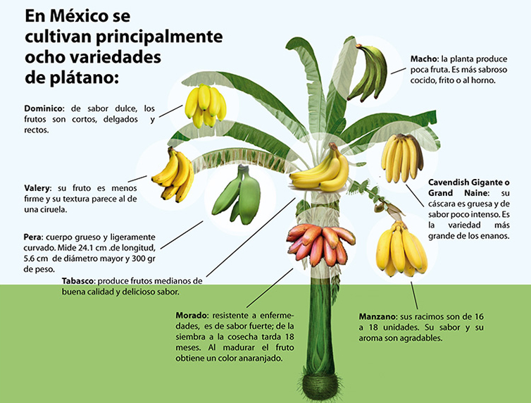
The Maya Biosana project apparently intends to plant only cacao Criollo. Of the three main varieties of cacao (see further reading for more details) – Forastero, Criollo and Trinitario –  Criollo produces the most flavorful chocolate, but is little used at present in the mainstream chocolate industry because it is very susceptible to disease, and takes longer to reach maturity. The most widely grown variety is Forastero, which is hardy but least flavorful, while Trinitario, a hybrid of the first two, falls somewhere in the middle.

This makes Criollo a very strange choice for such a major plantation. In fact, industry insiders say, there is no source anywhere in Mexico for the huge quantity of Criollo grafts that the Maya Biosana project would require.

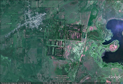
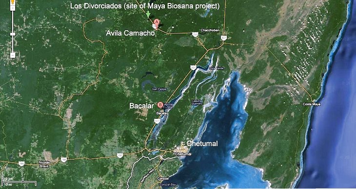
Maya Biosana claims that the first phase of its megaproject is already underway on land in the Los Divorciados ejido, about 100 km from Chetumal, and recently released a promotional video. The film includes lots of “feel good” footage and memorable quotes, but some of the footage of mature cacao appears to have been shot elsewhere, presumably in Tabasco state. More importantly, what exactly does the Maya Biosana team bring to the table, besides good intentions?

Who are the main players in Maya Biosana?

The two main players in Maya BioSana, according to press reports, are Jim Walsh and Fernando Manzanilla.

Entrepreneur Jim Walsh is the self-styled “reinventor of chocolate”, CEO of Hawaiian Vintage Chocolate from 1992, and CEO of the closely-related Intentional Chocolate since 2007. Fernando Manzanilla Prieto is a well-connected Mexican politician, member of Partido Acción Nacional (PAN), and businessman who is currently the Secretary General of the government of the state of Puebla in central Mexico.

According to its website, samples of Intentional Chocolate, co-founded by Walsh and Manzanilla, were given by former president Bill Clinton as a gift to the Japanese Royal family and have the seal of approval of the Dalai Lama. The company “treats” regular chocolate using “breakthrough licensed technology” that “helps embed the focused good intentions of experienced meditators and then infuses those intentions into chocolate”. An early press release stated that such chocolate can “significantly decrease stress, increase calmness, and lessen fatigue in those who consume it”.

The major claim made for this chocolate is that it elevates the mood of consumers more than non-intentioned chocolate does. This claim is based, apparently in its entirety, on a single “double-blind, randomized, placebo-controlled experiment”, the results of which were published in an article, co-authored by Walsh, entitled Effects of Intentionally Enhanced Chocolate on Mood in EXPLORE: The Journal of Science & Healing, an Elsevier journal, in the September/October issue of 2007 (Vol 3, No 5: 485-492).

The sample size was small, 62 individuals in total. For one week, participants self-recorded their mood by means of a recognized “profile of mood states”. Some participants consumed “intentioned” chocolate, and others “non-intentioned” chocolate, twice a day, at the same times, for three consecutive days, in the middle of the week.

The most fascinating part of the article is actually the last paragraph, where the authors recommend that efforts to replicate the findings should “seriously consider sources of intentional enhancement and contamination that might influence the postulated effect.” They call for intentional imprints to be provided only by “highly experienced meditators or other practitioners”, writing that “persons holding explicitly negative expectations should not be allowed to participate for the same reason that dirty test tubes are not allowed in biology experiments.” Even more bizarrely, they claim that vigilance about the intentions of people involved in the test may even extend to “people who learn about the experiment in the future after the study is completed”.

Put another way, skeptics and disbelievers should stay home.

To the best of our knowledge, the Explore study has not been replicated, while statisticians and others have criticized the methods used and the conclusions drawn. See, for example, Debunked: Effects of Intentionally Enhanced Chocolate on Mood.

The other two authors of the Explore study besides Walsh are Dean Radin and Gail Hayssen. Radin is a prolific author of articles about parapsychology and also just happens to be a co-editor of Explore. Both Radin and Hayssen hold posts at the Institute of Noetic Sciences in Petaluma, California.

Walsh and Radin, together with Manzanilla, all have connections to the Human Energy Systems Alliance (HESA) Institute,  “an alliance of scientists, philosophers, entrepreneurs, and spiritual leaders devoted to unlocking the potential of the human energy system and to developing technologies and products that transform human health and increase human flourishing.”

According to the HESA Institute’s list of its main members (webpage no longer active) , Walsh is the institute’s founder and CEO, and Radin is a prominent member. Manzanilla’s bio claims that he was, too, founded HESA but, curiously, his name is absent from the HESA Institute list.

Between them, Walsh and Manzanilla have created an impressive web of interlinked and overlapping projects, supported by an equally dazzling range of positions on advisory boards. For example, both men are members of the three-person advisory board of the Institute for Spirituality and Wellness (ISW) at the Chicago Theological Seminary (CTS), which continues “to educate and prepare future leaders for a multitude of ministries” (Ref). The CTS is an affiliated seminary of the United Church of Christ, “a mainline Protestant Christian denomination primarily in the Reformed tradition but also historically influenced by Lutheranism” (Ref).

Several of the projects associated with Manzanilla, according to his CTS bio, have surprisingly little or no web presence. For example, he founded (in 2007 according to his Linkedin profile) and remains CEO of ImaginaMéxico, which “directs a network of organizations whose brands encompass the areas of food and beverages, agro forestry and wellness, human capital and technology, all under the common theme of helping individuals lead more meaningful and vital lives.” Yet, as of last week, the ImaginaMéxico website was “under construction”. According to the bio, Manzanilla also founded Cielo y Tierra (no web links found), Facthum-Mexico (no website found) and Kakaw Universal (no evidence from a Google search that it even exists)…. Manzanilla also co-founded Baja BioSana,  “an intentional community with a vision to become an example of sustainable living and educational center” (Ref) located in the small village of El Choro in Baja Califórnia Sur.

Financial shenanigans

It now looks as if the Maya Biosana project may be dead in the water, before it ever really gets off the ground. According to this document from the Superior Audit Office of Mexico (Auditoría Superior de la Federación), Maya BioSana received two payments in 2010 from Financiera Rural, acting on behalf of Sagarpa, as part of the latter’s  Strategic Project for Sustainable Rural Development in the South-South-East Region of Mexico (Proyecto Estratégico para el Desarrollo Rural Sustentable de la Región Sur Sureste de México). The two payments totaled 15 million pesos (about $1,140,000 dollars).  The document states that Sagarpa is already requesting the return of these funds because the Maya Biosana project has fallen behind schedule.

The Superior Audit Office document says that visits to the site did not find any cacao plantation and alleges that the Sagarpa funds had been transferred from one company account to another before a payment for 12,400 million pesos (about $946,000 dollars) was made to a foreign bank account belonging to one of the individuals who had signed on behalf of the company “Maya Biosana S.A.P.I de C.V.” Perhaps this was the cost of the recently-released video?

For the sake of the ejidatorios of Los Divorciados in Quintana Roo, who were counting on the success of the Maya BioSana cacao-growing megaproject, we hope that they have gained, and will gain, more from this experience than they lost. They deserve far better than a mere handful of chocolate-coated intentions.

This is one chocolate megaproject that appears to be melting fast. Maya BioSana looks much more like Maya Bio-Insana.

Further reading:

  • Cacao domestication I: the origin of the cacao cultivated by the Mayas
  • Cacao domestication II: progenitor germplasm of the Trinitario cacao cultivar

Related posts:

Apr 162012
 

In just 20 years, Mexico has gone from a nation that needed to import less than 400,000 metric tons of corn (maize) a year in order to satisfy its domestic market to one where, in the 2011-12 season, it will need to import almost 10,000,000 tons.

One producers’ organization, Mexico’s National Confederation of Maize Growers (CNPAMM), argues that this reliance on imports has relegated the work done by its members to a relatively minor role in providing the nation with food. The growers claim that the price they receive for corn (post-NAFTA) has declined in the face of cheaper imports, jeopardizing their livelihoods. (For one view of the changes post-NAFTA, see NAFTA Truth and Consequences: Corn).

On the other hand, in the past few years, the costs of imported corn have risen sharply, meaning that consumers have to pay more for their tortillas. In order to preserve some stability, the Mexican government has bought corn futures which guarantee corn prices for a period of time.

How is it possible that the country that gave the world corn is now so dependent on imports of corn, almost all of which come from the USA? According to the CNPAMM, it is the result of speculation, market distortion and failures in Mexico’s economic policy. Héctor Carlos Salazar, the president of CNPAMM, called on maize growers to demand better prices, a reduction in imports, and some guarantees from the politicians fighting this year’s federal elections that they will take steps to ensure Mexico’s self-sufficiency in foodstuffs.

Salazar has been quoted in the press as offering some interesting statistics for the impacts of every additional ton of corn that Mexico imports from abroad. He claims that each ton imported reduces agricultural employment by 4.54 man-hours. It also reduces other inputs: diesel by 6 liters, fertilizers by about 100 kg, insecticides by 1 liter, pesticides by 3 liters and improved seeds by about 4 kg.

The bottom line is that it is not just the food security, particularly of Mexico’s poorest, that is threatened by rising corn imports, it is also Mexico’s economy.

Related posts:

Can Mexico’s decline in cacao production be reversed?

 Other  Comments Off on Can Mexico’s decline in cacao production be reversed?
Feb 162012
 

In a previous post, we looked at The geography of cacao production in Mexico. and saw how the area under cultivation and production have both fallen sharply since 2003. This post examines two recent projects that aim to reverse this recent trend of a steep decline in Mexico’s cacao production.

Major organic cacao project

The Agriculture Secretariat (Sagarpa) has several projects designed to rejuvenate Mexico’s cacao-growing sector. These include the production of young plants of high-yielding varieties, primarily in Tabasco for use in several southern states. Propagation method is either via grafting or via cuttings. (Tabasco is a leading centre for the development of tropical crops such as cacao, coconut palm and oil palm.)

In addition, Sagarpa is introducing improved methods of cultivation, harvesting and processing. The Secretariat is supporting a multi-phase plan to turn Mexico into the leading producer of organic cacao in the Americas. In the early phases, Maya Biosana will plant one million cacao trees to create 500 hectares (1200 acres) of irrigated orchards in 12 communities near Chetumal in Quintana Roo. The plan is to follow-up with similar numbers of new trees on additional land annually for another three years. The trees are expected to yield 2.4 metric tons of cacao per hectare (destined for high quality chocolates) and provide up to 2,000 additional jobs. [Note that the project is not without its critics, and we intend to write more about this in a future post].

NGO support for cacao producer cooperatives in Tabasco

One specific example of a project helping cacao farmers is the Chontalpa Cacao Presidium, a project initiated by the Slow Food Foundation. Tabasco’s most productive region for cacao is Chontalpa, which has ideal conditions for cacao cultivation and is the area where the criolla variety of cacao is thought to have originated.

Traditionally, farmers in the Chontalpa area have sold their cacao to intermediaries, who then market it. However, in recent years, groups (co-operatives) of farmers have been formed, enabling farmers to cut out the intermediaries and get higher prices for their harvest. The cooperatives allow joint purchasing and other economies of scale.

Serious flooding of cacao-growing regions in 2007 made it difficult for farmers to harvest and trade the cacao they had grown, and also helped spread the fungus Monilia roreri in their plantations. Many farmers gave up, sold their land and left for a new life elsewhere.

The Chontalpa Cacao Presidium was launched in September 2008 to help farmers rebuild the sector and introduce organic certification and other modern developments. Organic certification was obtained, which led to higher prices on the local market. The quality of beans was improved by using better post-harvest fermentation and drying methods.

This Chontalpa project currently benefits 18 producers, members of cooperatives in the Cárdenas and Centro municipalities. It helps farmers market the cacao directly in Mexico (and more recently in Italy) without the need for any intermediaries. The long-term objective is to establish a facility to produce semi-processed cocoa products.


How sustainable is organic agriculture on the Baja California Peninsula in Mexico?

 Mexico's geography in the Press, Updates to Geo-Mexico  Comments Off on How sustainable is organic agriculture on the Baja California Peninsula in Mexico?
Jan 192012
 

In recent years, a farming boom has completely changed the landscape in parts of Mexico’s Baja California Peninsula. The new landscape is comprised of organic farms, specializing in growing fresh produce, especially out-of-season, certified organic, fruits and vegetables, which carry premium prices.

“Organic” has come to mean very different things in different countries, but the essential common element is that it uses no synthetic fertilizers, hormones or pesticides. In the USA, the term “organic produce” also requires that farmers protect water resources, though this is hard to define and at least as hard to enforce.

The Baja California Peninsula receives very little rainfall, so irrigation water for its organic farms comes from underground aquifers. The profitability of these new farms relies on the availability of irrigation water and on the proximity of the region to the lucrative US market for organic produce.

The new farms may be “organic”, but the bigger question, examined by Elisabeth Rosenthal in Organic Agriculture May Be Outgrowing Its Ideals, in the New York Times is, “Are these organic farms sustainable?” Rosenthal looks in some detail at whether or not organic farms protect the local environment and the livelihood of local farmers. The article discusses the extreme stress being placed on the area’s ground water reserves. Some farmers are already in trouble because their wells have dried up. More than one-third of aquifers in the southern part of the peninsula are officially classified as “over-exploited”.

Growers blame the area’s tourism industry for the water shortages, arguing that hotels and golf courses gobble up far more than their fair share of the precious resource. Despite the aridity of the southern section of Baja California Peninsula, the southern coast, centered on Los Cabos, has far more golf courses per unit area than anywhere else in the country.

The “organic” label also takes no account of the emissions involved in production and transport of fruits and vegetables to the marketplace; export-oriented horticulture in the Baja Peninsula is an energy-intensive enterprise. Adding to the unsustainable side of the argument, some of the organic farms practice “monoculture”, growing a single crop year after year on the same land, a system known to lead to soil depletion and increase the risk of pest-related problems.

On the other hand, the new farms also provide an alternative source of jobs to tourism. Del Cabo, which has a cooperative packing plant in San José del Cabo and trucks or flies more than 7 metric tons of produce to the USA every day, is able to help its members by supplying high-quality seed, and employing specialists in plant raising and plant diseases who act as consultants to individual farmers as required. Del Cabo criticized the New York Times story for its numerous inaccuracies regarding water usage and sustainability.

Conscious of the water issues, many of these modern organic farms employ sophisticated, water-conserving irrigation systems, such as computerized drip irrigation. They also grow many crops under shade. Such systems are expensive to install and maintain, so most of the bigger producers are US-owned companies.

In Organic Tomatoes in January: Sucking Mexico Dry, in Mother Jones, Tom Philpott compares the situation in Baja California with that in “another region famous for winter tomatoes and dirt-cheap labor costs: Immokalee, Florida, source of a huge percentage of non-organic winter tomatoes consumed in the United States.” Philpott concludes that “What’s going on in Baja seems more about generating a premium-priced product while systematically degrading a landscape. Want organic tomatoes in the cold months? Buy them in a can.”

Food for thought!

Related posts: