The transformation of Chapala from fishing village to international tourist destination

 Other  Comments Off on The transformation of Chapala from fishing village to international tourist destination
Sep 032020
 

The town of Chapala, on the shores of Lake Chapala—Mexico’s largest natural lake—played an important role in the history of tourism in North America and has become one of the world’s premier retirement destinations. Yet, the details of how and why this transformation occurred have never been adequately reconstructed… until now!

Geo-Mexico is reader-supported. Purchases made via links on our site may, at no cost to you, earn us an affiliate commission. Learn more.

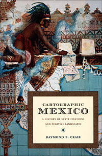
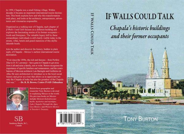
My latest book If Walls Could Talk: Chapala’s historic buildings and their former occupants, reveals the results of more than two decades of research. The book explores the history of the town’s formative years and shares the remarkable and revealing stories of its many historic buildings and their former residents.

The front cover shows the waterfront of Chapala at the start of the twentieth century. On the right is the parish church of San Francisco, which dates back to the sixteenth century and features in D. H. Lawrence‘s novel The Plumed Serpent, set at the lake. (The house Lawrence rented in 1923 is now a boutique bed and breakfast.) The turreted tower on the left is part of the Villa Ana Victoria which was built by the Collignon family of Guadalajara in the 1890s, right at the start of the village’s explosive growth.

The illustration is a photograph by American photographer Winfield Scott that was colorized and published in about 1905 by Jakob Granat, a postcard publisher based in Mexico City.

In 1890, Chapala was a small fishing village. Within decades it became an important international tourist destination. This book explains how and why this transformation took place, and looks at the architects, entrepreneurs, adventurers and visionaries responsible. The cast of characters includes Mexican and British politicians and diplomats, as well as the eccentric Englishman Septimus Crowe, who abandoned his wife and child in Norway and carved out a new life for himself by investing in Mexican mines and importing a German-built yacht to sail the lake. Crowe was the area’s first real estate developer and pressured friends and acquaintances to join him in Chapala. One of the town’s central streets is named after him.

Chapala’s transformation into an international tourist destination was aided by its links to dictatorial President Porfirio Díaz, whose wife’s relatives lived on the outskirts of the town, and by a host of business leaders and wealthy, high society families from Mexico City and Guadalajara.

The story of Chapala is truly international. The visionary Norwegian entrepreneur Christian Schjetnan refused to take no for an answer as he worked tirelessly to organize a Chapala Development Company, start a yacht club, run steamboats on the lake, and build a branch railroad linking Chapala to the Central Mexican Railroad mainline at La Capilla, near Atequiza.

Chapala’s first major hotel, the Hotel Arzapalo which opened in 1898, was built by a Mexican businessmen and had a succession of Italian managers, some more honest than others. Many members of the extensive French and German communities in Guadalajara also played key roles in the area, both by building private family villas in Chapala and by helping finance improvements and public buildings in the town.

Organized as a walking tour of Chapala, each of the 42 chapters of If Walls Could Talk focuses on a different building and explores the fascinating stories of its former occupants—locals and foreigners. The valuable legacy left by these extraordinary individuals is still clearly visible today in the streets, villas, hotels and grand mansions of this idyllic lakeside locale.

The book includes more than 40 vintage photographs and four original maps showing how Chapala’s street plan has changed over the years. The text is supported by a bibliography, index and detailed reference notes.
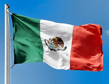
Mexico celebrates 208 years of independence

 Other  Comments Off on Mexico celebrates 208 years of independence
Sep 142018
 

Happy birthday, Mexico! On 16 September 2018, Mexico celebrates the 208th anniversary of its independence from Spain.

Mexican flag

Geo-Mexico is reader-supported. Purchases made via links on our site may, at no cost to you, earn us an affiliate commission. Learn more.

When was Mexico’s War of Independence?

The long struggle for independence began on 16 September 1810; independence was finally “granted” by Spain in 1821.

Want some map-related geographic trivia associated with the War of Independence?

Events in the War of Independence called for an accurate map of Lake Chapala, Mexico’s largest natural lake. The cartographer for this map was José María Narváez, whose major contributions to Mexican cartography in succeeding decades have largely been forgotten.

The first truly national map, compiled in 1857-1858 from a meticulous reconciling of the work of numerous local cartographers, was drawn by Antonio García Cubas. García Cubas did not graduate from university until a few years after completing this map!

Nationalism and the start of Mexico-USA migration, but not in the direction you might think…

Following independence, the rush was on to draw an accurate map of all of Mexico’s territory. Mexico’s boundaries following independence were very different to today. Flows of migrants linking the USA to Mexico at that time were from the USA to Mexico, the reverse of the direction of more recent flows, which have seen millions of Mexicans migrate north looking for work:

Some national symbols are not quite what you might think, either!

The story of the national emblem (used on coins, documents and the flag) of an eagle devouring a serpent, while perched on a prickly-pear cactus, is well known. Or is it?

Why is “El Grito” held on the night of 15 September each year?

In 1910, then president Porfirio Díaz decided that the centenary of Mexican independence should be celebrated in style. One of the reasons why the “traditional” Grito (“shout”) is made on 15 September each year, rather than on the morning of 16 September (when Father Miguel Hidalgo apparently gathered his parishioners in revolt) is because 15 September 1910 happened to be Díaz’s 80th birthday. Why not have one big bash and celebrate both president and country at the same time? Even though the Mexican Revolution broke out later that year (and Díaz was later exiled to Paris), Mexico continues to start its annual independence-day celebrations on the evening of 15 September.

Not to be confused with Cinco de Mayo (5 May)

Many people incorrectly assume that Cinco de Mayo (5 May) is Mexico’s independence day. The Cinco de Mayo has nothing to do with Independence, but everything to do with a famous victory over the French. It commemorates the Battle of Puebla, fought on May 5, 1862. The battle marks Mexico’s only major military success since independence:

Independent country, independent book:

Mexico has come a long way in 200 years, but amazingly, to the best of our knowledge, Geo-Mexico: the geography and dynamics of modern Mexico, is the first-ever book in English focused exclusively on the nation’s varied and fascinating geography.

¡Viva Mexico!

Mexican flag

Geo-Mexico wishes you a Happy Cinco de Mayo (5 May)!

 Other  Comments Off on Geo-Mexico wishes you a Happy Cinco de Mayo (5 May)!
May 032018
 

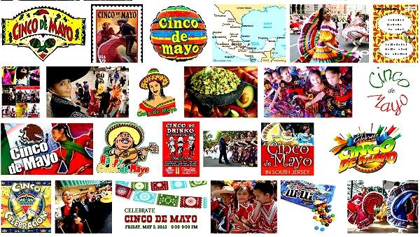
The holiday of Cinco de Mayo (5 May) commemorates the Battle of Puebla, fought on May 5, 1862. The battle (against the French) marks Mexico’s only major military success since its independence from Spain in 1821. Today, in a curious example of cultural adaptation, the resulting holiday is actually celebrated more widely in the USA than in Mexico!

Cinco de Mayo: Google image search results

Cinco de Mayo: Google image search results

For an account of the history behind the Cinco de Mayo, and for an explanation of why the holiday is now celebrated more in the USA than in Mexico:

In Mexico, Cinco de Mayo is celebrated with a parade in the City of Puebla each year, but, in another strange twist of geography,  the longest-running annual re-enactment takes place in Mexico City:

Want to read more?

MexConnect has several informative articles relating to Cinco de Mayo, including:

Mexico and Ireland: a lasting relationship forged by potatoes. Happy St. Patrick’s Day!

 Other  Comments Off on Mexico and Ireland: a lasting relationship forged by potatoes. Happy St. Patrick’s Day!
Mar 152017
 

In honor of St. Patrick’s Day, we offer this short list of references highlighting some of the more significant connections between Ireland and Mexico.

Séamus Ó Fógartaigh in his “Ireland and Mexico“, published in Irish Migration Studies in Latin America by the Society for Irish Latin American Studies (based, curiously, in Switzerland) looks at the early links between Ireland and Mexico, including suggestions that the travels of St. Brendan the Navigator may have inspired Christopher Columbus and that the famous “Plumed Serpent” of Mexican mythology may have originated from the deification of an Irish monk.

Much better known are the later links. During colonial times, several of the Spanish administrators sent to New Spain (now Mexico) were direct descents of Irish exiles to Spain. They include the 63rd and last Spanish Viceroy of New Spain Juan O’Donojú (formerly O’Donoghue) who arrived in the New World shortly before Mexico became Independent in 1821.

A generation later, Irish soldiers who chose to leave (deserted) the US army formed the backbone of Mexico’s St. Patrick’s Battalion (Batallón San Patricio) which fought the invading Americans in 1846-48. They are especially remembered for their bravery in the Battle of Churubusco (in Mexico City) in 1847. Their story is well remembered by Mexicans today, their exploits commemorated every year at a ceremony in Mexico City, and the basis of several books and the movie One Man’s Hero. The single, best account is that by Michael Hogan in The Irish Soldiers of Mexico. For a summary account, try “The St. Patricio Battalion, The Irish Soldiers of Mexico” by Jaime Fogarty, published in UNAM’s Voices of Mexico magazine, April-June, 2000.

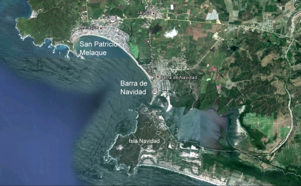
San Patricio Melaque (Google Earth)

San Patricio Melaque (Google Earth)

On the Jalisco coast, the small town of San Patricio Melaque (around the bay from Barra de Navidad and the Isla de Navidad tourist development) holds an annual fiesta that celebrates both the town’s patron saint and the achievements of the Irish soldiers. Nine days of activity (church services, fireworks, parades, bullfights, fairground games) come to a climax on 17 March. (It is sometimes claimed that San Patricio Melaque is the only settlement named San Patricio in Mexico, but that is not quite true, since there are at least three others: two tiny hamlets called San Patricio, relatively close to Cd. Victoria in Tamaulipas, and one named San Patricio de la Mesa in the mountains east of Hermosillo in Sonora.)

In the twentieth century, Álvaro Obregón (family name O’Brien) was President of Mexico from 1920 to 1924. (We will take a critical look at his relationship with the indigenous Yaqui Indians of Sonora in a later post). The city of Ciudad Obregón in Sonora is named in his honor. Artists of Irish descent also impacted Mexico’s national life. They included architect, painter and muralist Juan O’Gorman (1905-1982), responsible for the monumental mosaic that adorns the walls of the National University (UNAM) Library in Mexico City, and a striking, colorful mural in Pátzcuaro that depicts an erupting volcano; this mural was completed just one year before the unexpected eruption nearby of Paricutín Volcano.

Today, according to Wikipedia, there are between 300,000 and 600,000 people of Irish descent living in Mexico, mostly in either northern Mexico or Mexico City.

Dr. Michael Hogan has done far more than most to publicize the links between Ireland and Mexico.

Most of the links we’ve described might never have happened if Mexico had not sent an unwanted export to Ireland in the middle of the nineteenth century. The census of 1841 in Ireland recorded a population of about 8 million. The staple Irish food at that time was the humble potato and Ireland’s rapid population growth during the early part of the nineteenth century was based on the so-called “potato economy”.  Ireland was bursting at the seams in 1841, but just a decade later, after the potato famine, the population had fallen to 6.5 million. The cause of the Irish potato famine was a water mold (Phytophthora infestans) that originated in Mexico and crossed the Atlantic in the 1840s, reaching Europe in 1845 before rapidly spreading across the continent to reach Ireland.

If a Mexican water mold had not provoked the Irish potato famine, maybe there would have been no settlements named San Patricio in Mexico today, and no cause to celebrate St. Patrick’s Day in Mexico! Wherever you may be, have a very Happy St. Patrick’s Day!

Related links:

Geography, residence patterns and architecture in the mining town of Santa Rosalía, Baja California Sur

 Other  Comments Off on Geography, residence patterns and architecture in the mining town of Santa Rosalía, Baja California Sur
Mar 092017
 

In a previous post — The re-opening of the giant El Boleo copper mine in Santa Rosalía, Baja California Sur —  we looked at the repeated boom-bust-boom history of the copper mining center of Santa Rosalía on the Baja California Peninsula. The arid peninsula did not offer much in the way of local resources for the construction of a mining settlement. When mining took off, an entire town was needed, virtually overnight. Almost all the materials necessary for the construction and exploitation of the mines and for building the houses and public buildings had to be imported, primarily from the USA.

As the town grew at the end of the nineteenth century, a clear geographic (spatial) segregation developed, which is still noticeable even today:

  • Workers’ homes were built on the lowland near the foundry and port
  • Higher up the slope was the Mexican quarter where government workers and ancillary support staff lived
  • The highest section of town, overlooking everything, was the French quarter.

The contrasts of Santa Rosalía at this time were well summed by María Eugenia B. de Novelo:

“Santa Rosalía was a place of clashing contrasts and situations. It had a scarred backdrop of copper hills, a black-tinted shore, French silks, fine perfumes, crystal, Bordeaux wines and Duret cooking oil, sharing the scene with flour tortillas, giant lobsters, abalone and chimney dust.”

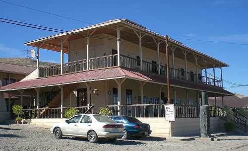
The French quarter has retained its distinctive architecture to the present day. At one end is the Hotel Francés, opened in 1886, which has an incredibly stylish period interior and still operates today.

Hotel Francés, Santa Rosalía

Hotel Francés, Santa Rosalía. Photo: Tony Burton

The gorgeous architecture of many of the homes of the French quarter is reminiscent of New Orleans. Beautiful wooden houses stand aloof on blocks with porches, balconies and verandas, competing for the best view over the town below. Wooden homes are decidedly unusual in this part of Mexico, which was never forested, and are, indeed, rare almost everywhere in the country. There are so many wooden homes here that Santa Rosalía has long had its own fire department, just in case!

At the other end of the French quarter are the former mining offices, now the Museo Boléo, an interesting museum where interior details are little changed from a century ago. Standing in the main hall, it is possible to imagine the hustle and bustle of former days, as clerks work feverishly to keep up with their superiors’ numerous demands. The mining company attracted workers from far afield. Three thousand Chinese workers arrived, settling the districts still known as La Chinita and Nuevo Pekin.

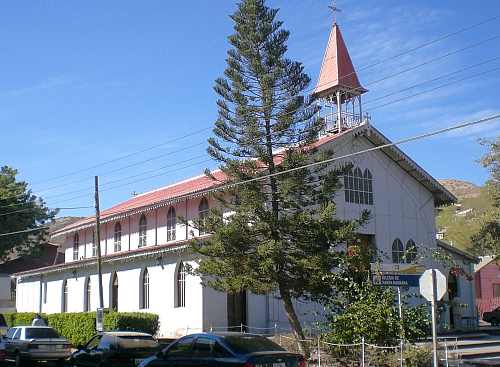
The most conspicuous landmark in the main part of town remains the former foundry, no longer open to the public. The next most conspicuous landmark is the church of Santa Bárbara. There are serious doubts as to who designed this unusual church, assembled out of pre-fabricated, stamped steel sheets or plates. Most guidebooks attribute the church to Gustave Eiffel, the famous French architect responsible for the Eiffel Town in Paris. According to this version, Eiffel’s design won a prize at the 1889 Universal Exposition of Paris, France, and was originally destined for somewhere in Africa. It was later discovered in Belgium by an official of the Boleo mining company, who purchased it and brought it back to Santa Rosalía in 1897.
The church of Santa Rosalía

The church of Santa Rosalía. Photo: Tony Burton.

The latter part of the story may be correct, but research by Angela Gardner (see Fagrell, 1995) strongly suggests that the original designer was probably not Eiffel but is far more likely to have been a Brazilian, Bibiano Duclos, who graduated from the same academy as Eiffel in Paris. Duclos took out a patent on pre-fabricated buildings, whereas there is no evidence that Eiffel ever designed a pre-fabricated building of any kind. Whoever designed it, it is certainly a unique design in the context of Mexico, and well worth seeing.

Other well-preserved buildings dating back to the heyday of the town’s success include the municipal palace or town hall (formerly a school designed by Gustave Eiffel), the Central Hotel, the DIF building, the Club Mutualista, the Post Office and the Mahatma Gandhi library, currently being restored. The library is in Parque Morelos, which is also the last resting place for a Baldwin locomotive dating back to 1886.

If walking around town looking at the architecture makes you hungry, try the French pastries (and Mexican sweet breads) from the Panadería El Boleo on the main street. With slight hyperbole, Panadería El Boleo boasts on its wall of being the World’s most famous bakery. Expect to queue, but enjoy the smells of fresh baked goods while you wait.

The distinctive history, architecture (and pastries) of Santa Rosalía, assuming they are conserved, should prove in the future to be an excellent basis for the development of cultural tourism to supplement the ecotourism and adventure tourism already in place.

Sources:

Want to read more?

Note : This post was first published 11 October 2011.

No wall necessary: the USA-Mexico border at Nogales in 1915

 Other  Comments Off on No wall necessary: the USA-Mexico border at Nogales in 1915
Feb 232017
 

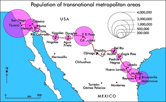
There are almost fifty places where people can legally cross the Mexico–United States border, but only one where the cities on either side of the border have the same name: Nogales.
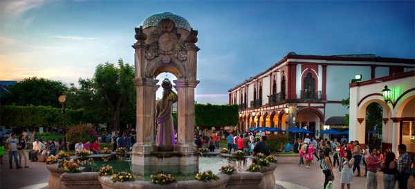
transnational-metropolitan-areas

The fascinating history of the two Nogales (Ambos Nogales), twin cities on either side of the border, is related in this detailed 2010 blog post by Robert Lucas: Ambos Nogales Face Across the Border.

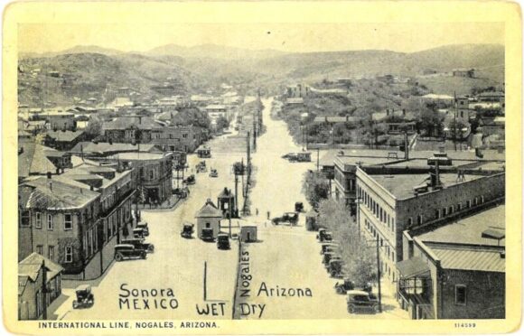
The geographic curiosities of the border between Nogales (Sonora) and Nogales (Arizona) included, historically, a street that ran east-west along the border, with one half of the street in Mexico and the other half in the USA:

Postcard of Ambos Nogales, ca 1915

Postcard of Ambos Nogales, ca 1915

This postcard from about one hundred years ago shows International Avenue, Nogales. The boundary line on the postcard was added by the publisher to indicate that the border ran down the middle of the street. Even in the absence of any boundary fence, residents were apparently still required to cross at one of two entry points: either the Morley Avenue crossing (shown in the postcard) or the Grand Avenue crossing further to the west.
Prior to the building of the International Avenue, which created a clear separation between Mexico and the USA, there had been some interesting consequences of having a bi-national city straddling the international border. For example, after Arizona introduced prohibition, outlawing the production and sale of alcohol in that state, some publicans took advantage of the unusual geography of Nogales to build saloons that straddled the border. Patrons tired of sipping their tea who wanted to enjoy duty-free mescal could simply move to the south end of the bar…

In 1897, the U.S. Congress ordered that a 60-foot strip along the border in downtown Nogales be cleared of all structures as a measure to suppress customs fraud. Mexico soon followed suit, creating the International Avenue. The International Avenue did not look like the view in the postcard for for very long. By 1916, a temporary fence had been erected down the middle.

Two years later, on 27 August 1918, this area was the scene of the Battle of Ambos Nogales (La batalla del 27 de agosto), which led to a permanent fence being built, forever separating Ambos Nogales into two distinct cities.

Related posts:

Alexander von Humboldt’s visit to Mexico, 1803-1804

 Other  Comments Off on Alexander von Humboldt’s visit to Mexico, 1803-1804
Sep 292016
 

Alexander von Humboldt‘s visit to Mexico began in Acapulco on March 22, 1803, and lasted for almost a year. (He left Mexico via Veracruz for the USA on March 7, 1804.) In his year in Mexico, Humboldt had been incredibly busy. He had measured, recorded, observed and written about anything and everything, with remarkable industry and accuracy. He had climbed mountains, burned his boots on active volcanoes, descended into mines, recorded geographical coordinates, and collected numerous specimens and antiquities. Humboldt’s Political Essay on the Kingdom of New Spain was the first systematic scientific description of the New World. It appeared in 1811, and marked the birth of modern geography in Mexico. His figures and ideas were used and quoted by writers for many many years.

Humboldt had also drawn a large number of maps, drawings and sketches and it can rightly be claimed that the modern era of Mexican map-making began with Alexander von Humboldt, and was then developed further later in the 19th century by cartographers such as Antonio García Cubas.

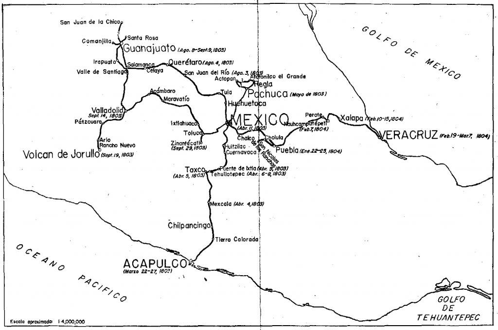
Humboldt's route in Mexico

Humboldt’s route in Mexico. Click to enlarge

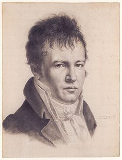
Alexander von Humboldt (Self-portrait c1814)

Alexander von Humboldt (Self-portrait c1814)

The map above shows the route followed by Humboldt during his time in Mexico. The map comes from the book La obra de Alexander von Humboldt en México by Rayfred Lionel Stevens-Middleton  (Mexico D.F.: Instituto Panamericano de Geografía e Historía, 1956). This hard-to-find work is a comprehensive account of Humboldt’s time in Mexico and of his significance for the development of what the author refers to as “modern geography”.

The map of Humboldt’s route in Mexico includes his various side trips such as those to Jorullo Volcano and Santa María Regla.

Humboldt was keen to see Jorullo Volcano, since it was a rare example of a brand new volcano, one of only a handful of volcanoes that have emerged on land anywhere in the world in historic times. Jorullo first erupted on 29 September 1759 and activity continued for 15 years until 1774. Two centuries later, and about 80 km (50 miles) away, Paricutín Volcano burst into action for the first time, in a farmer’s field in 1943.

Santa María Regla, in the state of Hidalgo, about an hour’s drive north of Mexico City, is the best known location in Mexico for basalt columns. The columns, up to 40 meters tall,  are attractively located on the side of a canyon, with a waterfall tumbling over some of them:

Despite only seeing a relatively small part of the country (New Spain as it then was), Humboldt was able to make some generalizations about geography in general, and Mexican geography in particular, that have stood the test of time remarkably well. For example, he was the first to describe the vertical differentiation of climatic and vegetation zones in Mexico. Writing in 1811, he proposed the terms tierra caliente, tierra templada, and tierra fría, terms still widely used by non-specialists today:

Related posts:

Note: this post was first published on May 7, 2012.

Sep 192016
 

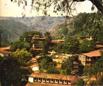
In its day, the San José Purua spa-hotel in Michoacán was world-famous. Opened in the early 1940s, it was the epitome of luxury living. European chefs cooked for the guests. Cabaret and touring acts from all over the world performed in its small night club. An on-site bowling alley provided some entertainment for the younger set. The hotel’s popularity led to the access road, complete with its “La Curva de la Gringa“, being paved for the first time in the mid 1940s. One writer mentions that he saw cars with license plates from no fewer than eight different countries in the hotel’s car park—all at the same time!

San José Purua spa hotel (from an early brochure)

Guidebooks of the time all extolled its virtues, and its peculiarities. For example, this is how Sydney Clark, in “Mexico Magnetic Southland” (1944), described the hotel:

“The hotel, designed in a curious arc with a high bridge leading to the comedor (dining room) is located on a narrow shelf of land on the side of the extremely deep gorge of the Tuxpan River. To beautify the setting, and also for utilitarian reasons, the management has planted no less than fifteen thousand orange trees on the gorge-side, and along with these some coffee trees. There are two large swimming pools with warm radioactive water gushing into them all the time directly from the cliff. It oxidizes in the open air within a few minutes and turns to an odd café au lait color so that the pool is always brown. However, it is no whit less clean than any spring fresh from the earth, and the curative properties are said to be extremely potent.”

Sadly, the San José Purua hotel ran into ownership and management problems and is now but a poor shadow of its former self, though the grounds and pools can still be admired. Several attempts have been made to relaunch the hotel as a luxury resort, but so far none has succeeded.

If you want to overnight or vacation in this magnificent part of Mexico, the best place by far is slightly further down the valley, at the Agua Blanca Canyon Resort, a charming, small hotel with just 20 rooms set in stunning scenery, with its lawns overlooking the deeply carved valley of the River Tuxpan.

This is a geographer’s delight! Waterfalls, rock formations, the meanders of the Tuxpan River, steep canyon slopes… what more could one want? This was one of the first locations in Mexico where high school students were actively engaged in geography fieldwork investigations thirty years ago.

In February 2010, a short distance upstream, the Tuxpan River burst its banks flooding the town of Tuxpan and other nearby settlements in Michoacán.

This is also the region where director John Huston filmed parts of “The Treasure of the Sierra Madre“, starring Humphrey Bogart, in 1947 (he used the San José Purua hotel as his base), but that’s a whole other story.

Sep 142016
 

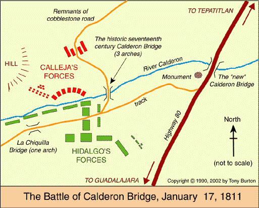
The battle in question is the Battle of Calderón Bridge (Batalla del Puente de Calderón), fought just outside Guadalajara in January 1811 as part of Mexico’s fight for Independence. The decisive battle was waged on the morning of Thursday, January 17.

On one side was Ignacio Allende with some 80,000 ill-equipped and untrained supporters of Father Miguel Hidalgo, the priest who launched Mexico on the road to Independence. On the other side was the numerically much smaller, but professional, Royalist army led by General Félix María Calleja, fighting for the King of Spain .

After six hours of fighting, a stray grenade from the Royalist side landed smack in the middle of the insurgents’ ammunition supplies, resulting in a fearful explosion and fire which brought the battle to a speedy end. Hidalgo and his men fled northwards; the crown troops followed, hot on their heels. The loss of this battle effectively dashed hopes of any quick independence from Spain. Mexico’s  Independence was delayed another ten years, until 1821.

The area where this important battle took place is between Guadalajara and Tepatitla, in the state of Jalisco. A few kilometers beyond Zapotlanejo, the site is clearly marked by a large monument to Father Hidalgo, prompting one to reflect on how often the losers of a battle are commemorated, rather than the winners. The statue overlooks the battlefield: the shallow valley of the Calderón river. In Hidalgo’s time, only a single bridge spanned the river. It was made a national monument in 1932.

Today, three different bridges exist in the general vicinity of the battle and a fourth, not far away, is used by the toll highway to Lagos de Moreno. It’s easy to tell which of the four bridges is the correct one, since it has a plaque commemorating the event!

Curiously, the historically-accepted plan of the battle, reproduced in dozens of scholarly works and hung on display in many museums around the country (still including, to the best of my knowledge, the Regional Museum in Guadalajara) is in fact, upside down! The true orientation of the map was proven (way beyond any reasonable doubt) by Mexican geographer Alma Rosa Bárcenas. In a brilliant and clearly written article, which appeared in the first isue of “Geografía”, published by INEGI in Mexico City in 1986, she clears up the confusion surrounding the exact site of the battle.

She proves, using both field-work and aerial photographs to supplement contemporary battle descriptions which give clues to terrain, slopes and visibility, that the map was drawn “south-upwards”. The map’s “north arrow” actually points due south!

Here is the battle plan the right way round. At last, the battle descriptions make sense! Now, anyone visiting the battle site has a chance to work out for themselves the true dispositions of the troops on both sides, and relive, if only in their imagination, the course of this key battle in Mexico’s War of Independence…

This is an edited version of an article originally published on MexConnect. Click here for the original article

Geo-Mexico: the geography and dynamics of modern Mexico takes an in-depth look at the implications of Mexico’s 1810-1821 War of Independence for the development of transportation and communications systems, as well as migration patterns, settlements and many other aspects of Mexico’s geography and development.

As an added bonus, it has no maps that are upside-down!

Novelist Charles Fleming Embree, an honorary geographer

 Other  Comments Off on Novelist Charles Fleming Embree, an honorary geographer
May 302016
 

American author Charles Fleming Embree‘s A dream of a throne, the story of a Mexican revolt, published in 1900, is, I believe, the earliest novel in any language about the Lake Chapala area. It is an historical novel, set in the area during the nineteenth century, but Embree reveals an extraordinary depth of knowledge, not only of the history of this area, but also of its geography.

Embree was only 24 years of age when he and his wife Virginia, newly-weds at the time, arrived in Chapala in 1898. Embree had dropped out of Wabash College in his native Indiana, without completing his degree, to devote himself to his writing and his first book, a collections of stories entitled For the Love of Tonita, and other tales of the Mesas (1897) had proved successful.

The Embrees lived in Chapala for eight months in 1898, before traveling to other parts of Mexico, including Guanajauto, Xalapa, Cuernavaca and Oaxaca. Embree’s publishers described A dream of a throne as, “A powerful and highly dramatic romance, dealing with a popular Mexican uprising half a century ago. It is a novel of adventure and of war, and its strongly contrasted characters glow with life and realism. The writer’s thorough knowledge of Mexican life gives him a wealth of new material; and the descriptions of scenery at Lake Chapala are vivid, full of color, and alive with mountain air”.

A Dream of a Throne by Charles F. Embree

A Dream of a Throne by Charles F. Embree

The book is indeed a remarkable achievement. Despite only living at Lake Chapala for a few months, Embree acquired and demonstrates, from a geographical perspective, an extraordinarily accurate and astute knowledge of all his lakeside locales. The spelling of all place-names, with the exception of Ajicjic and Tuxcueco, is exactly as it is today. Details of clothing, habits and customs all ring true. Embree’s knowledge of the region’s nineteenth century history is equally impressive. As one small example, the story begins in the shadow of St. Michael’s hill in Chapala in May 1833, amidst fear of an epidemic of smallpox. In real life, the nearby city of Guadalajara suffered a cholera epidemic in the summer of 1833.

From a human geography perspective, this novel offers us one of the earliest descriptions of everyday indigenous life in the region. As Dr. Wolfgang Vogt of the University of Guadalajara has pointed out, even by the 1920s (twenty years after Embree’s novel), virtually no-one was observing or writing about this area from an indigenous point of view. Embree’s novel has particular value since it examines the conflicts between Indians and Spaniards, anticipating the themes explored by D. H. Lawrence when he visited Chapala for a couple of months in 1923 and penned the first draft of The Plumed Serpent.

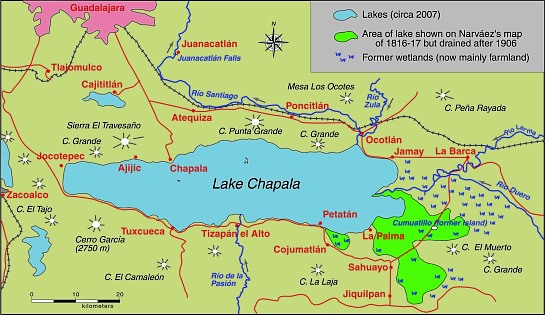
All the action in Embree’s novel takes place on and around Lake Chapala. The major locales are Mezcala Island, Chapala, Ajijic and Tizapan. The following extracts have been chosen to highlight his depictions of the local landscapes. Lake Chapala was significantly larger in 1898 than it is today (see The eastern end of Mexico’s largest lake, Lake Chapala, is amputated):

Lake Chapala, showing area drained at start of 20th century. Map: Tony Burton. All rights reserved.

Lake Chapala, showing area drained at start of 20th century. Map: Tony Burton. All rights reserved.

Here is Embree’s description of Ajijic:

They were riding over a rough trail with cacti and stones about, and here and there a flock of goats. To the right was a seemingly endless chain of mountains, to the left, more distant, rose St. Michael, low and round (behind whose bulk lay Chapala and the water), and the larger head, called Angostura, lying between that town and Ajicjic on the lake’s edge. Between Angostura and the opposite mountain chain the road led, rising to a hill, to whose summit the little army came. They looked down on the lake and, nearer, small irregular fields, scores of them, checkering a level stretch from mountains to water. Out of these, Ajicjic’s church thrust up a single gleaming tower of white. Three o’clock found the troop sweeping into the barren plaza of that fishing village.

To this day Ajicjic can claim no more than some two thousand souls. It has, even yet, no railroad, no stage; rarely has a vehicle been seen in that primitive place other than the awkward oxcart. Its low, unplastered adobe walls stand close together. The streets are alleys of extreme narrowness wherein there is mud when it rains, dust when it is dry, rocks and swine forever. Nigh every alley twists and turns, is for a block no more than a gutter, for another block a public stable for burros. Yet one may find some better quarters. The plaza, though it is only a bare, brown waste, is wide. The open court before the church, though it too is bare and dirty, with lonely, crumbling walls and pillars about it, yet has in its center a weather-beaten cross that speaks of service to the Lord.

The troop filled the plaza. It was halted, and the inhabitants of the town, struck with amazement, either shut themselves up or gathered in silence round about. Groups of brown children, absolutely naked, sat down in the dirt, thumbs in mouth, to wonder in comfort. Rodrigo and Bonavidas began the inquiries, prefacing them with jocularly expressed friendship to certain storekeepers and a toss of tequila here and there down a willing throat. Boats? There hadn’t come but one boat to Ajicjic the blessed day. Ajicjic was losing importance in these times. On market days everybody went to the bigger market at Chapala, where the news was dispersed. And this one boat? It had come from Tizapan with a load of wood for the lime burners.

His landscape descriptions are equally adept:

The town of Tizapan lies at a short distance from the lake. The shore in that region is no such distinctly marked line of beach and rock as it is at Chapala. It is not even always easy to tell where the shore is. Between water and land there is a stretch of marsh for several hundred yards, watery, pierced by the spears of a million reeds that rise thick and green to a height of some feet. Here flock ducks in great numbers. The marsh is flat, bewildering, and dreary. Through its middle a stream, called the Tizapan River, cuts out more than one course, having formed a delta. The main course of this river, not over twenty yards at its widest part, usually much narrower, is navigable for canoas for half a mile to a point where the land is dry and from which the town lies yet another mile distant. The stream being crooked and the curves sharp, the progress from the open lake to the inner landing is usually made by poles. The lake approach to the town could be easily blocked by blocking the river. Only the one course is navigable. Nobody could cross the marshes. This fact was recognized more than a century ago.

The town itself is like the greater part of Mexican towns, narrow and crooked streets with the low houses (joined together) shutting those streets in and making them seem even narrower, and the central plaza of considerable size left vacant. That plaza is today filled with flowers and fruit and contains a bandstand. In former times it was bare. The mountains rise only a little way behind the town, jagged and huge. Before them is a stretch of rolling green fields. The river, coming from the peaks, dashes down through this pastoral scene with a vivacity that has laid bare a rough and rocky bed whereon the water boils till it passes through the town. At the time when the two small armies were approaching Tizapan, much of the summer green was still on field and mountain. The unclouded sun poured his light over an emerald gem of the lake’s border.

After their time in Mexico, the Embrees settled in Santa Ana, California. Embree published his second novel A Heart of Flame: the Story of a Master Passion in 1901, and supplied a steady stream of short stories to major magazines, including McClure’s, the San Francisco Argonaut and Sunset Magazine. Sadly, the couple had not long celebrated the birth of their only daughter Elinor in 1905 when Embree was taken seriously ill. He died on July 3, not yet 31 years old.

It is tragic that someone who had produced work of this magnitude, should have died so terribly young. In his short time in Chapala, Charles Embree had acquired an excellent historical and geographical knowledge of the region at a time when American travelers to the lake were few and far between. Geo-Mexico believes that Charles Fleming Embree fully deserves to be declared an Honorary Geographer.

Note: The post is based on chapter 43 of Lake Chapala through the ages; an anthology of travellers’ tales (Sombrero Books, 2008) and on American novelist Charles Fleming Embree set his first novel at Lake Chapala” (MexConnect, 2009).

Related posts:


Mar 112016
 

Spanish seaman José María Narváez (1768-1840) was an explorer and cartographer, whose major contributions to Mexican cartography in the first half of the eighteenth century have been largely forgotten.

Narváez did not even give his name to what ranks as probably his greatest “discovery” – the stretch of water on the west coast of Canada now known as the Georgia Strait, on the eastern shore of which is the major city of Vancouver. While Captain George Vancouver is usually given the credit for exploring the Georgia Strait and discovering the site of the city that now bears his name, it was actually José María Narváez y Gervete who was the first European to sail and chart those waters, in 1791, a full year before Capt. Vancouver.

Why has history largely overlooked the contributions of Narváez? The likely cause, in the words of historian Jim McDowell who has written a wonderful biography of Narváez, is because he probed northwards “as an uncelebrated 23-year-old pilot in command of a small sloop, the Santa Saturnina, and longboat.”

Born in 1768, probably in Cadiz, Narváez entered the Spanish Naval Academy in April 1782 at the tender age of 14, and soon saw his first combat at sea. In 1784, he sailed west, visiting various places in the Caribbean, as well as New Spain.

In February 1788, he arrived to take up an assignment at the naval station in the busy Pacific coast port of San Blas. For the next seven years, he explored the coast to the north, including the Strait of Georgia, which today separates Vancouver Island from the city of Vancouver. He also sailed to Manila, in the Philippines, Macao and Japan.

In the summer of 1791 Narváez, on the orders of Captain Alejandro Malaspina, sailed his sloop, which was less than forty feet long, into the strait of Georgia (then more grandly known as El Grand Canal de Nuestra Señora del Rosario la Marinera!), and continued past the mudflats at the mouth of the River Fraser as far north as Texada and Ballenas islands, before turning back to reprovision his vessel. Like any good cartographer, he charted his route meticulously as he went.

His motivation, as Roger Boshier points out, was because, “The place now labeled British Columbia was thought to contain the throat of the fabled Straits of Anian which led from the Pacific back to the Atlantic. Whoever pushed through this strait would secure considerable power, authority and prestige for their king.”

The following year, Captain George Vancouver was understandably distressed when he was shown the Narváez chart and realized that the Spaniards had gained a clear lead in the race to map the coastline, and might beat the English in finding the Anian Straits. In the event, neither side won, since the Straits proved to be a figment of the imagination of earlier sailors.

Narváez returned to his base in San Blas, Mexico. On October 23, 1796, he married María Leonarda Aleja Maldonado in her hometown of Tepic. The couple raised six sons and a daughter. One of his direct descendants, a great-great-great grandson, José López de Portillo, was President of Mexico from 1976 to 1782.

Santa Saturnina and San Carlos

Santa Saturnina and San Carlos

After 1797, Narváez busied himself mapping different parts of Mexico’s west coast. In 1808, he surveyed the route for a new road between San Blas and Tepic. In November, 1810, at the start of the War of Independence, Narváez found himself unable to prevent San Blas from falling to the insurgents. His superiors tried to court-martial him for failure to defend the port, but Narváez successfully argued that the real cause had been a lack of firepower, since his men had only 110 rifles and shotguns at their disposal.

Over the winter of 1813-1814, Narváez was ordered to sail across the Pacific once more to take Spain’s new constitution to Manila. (For more about Mexico-Philippines links, see Mexico’s long connection with the Philippines – exploration, seafaring and geopolitics and Cultural exchanges between Mexico and the Philippines)

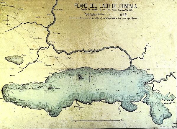
On his return, Narváez was summoned to Lake Chapala, where a group of determined insurgents had installed themselves on the island of Mezcala and were refusing to surrender. General de la Cruz requested help from the Spanish Navy, and Narváez duly obliged. The Royalist troops and the rebels agreed an honorable truce in November 1816, by which time Narváez had begun his map of the lake. He completed the map the following year, and several years later had produced a truly fine map of the entire province of Jalisco, a scaled down version of which, with updated boundaries, became the first official map of the state in 1842.

Copy of Narvaez' map of Lake Chapala

Copy of Narvaez’ map of Lake Chapala

Narváez’s map of Lake Chapala was the earliest scientific map of the lake, and was adapted, with only minor modifications, by many later publications. The map shows the lake to have a maximum depth of 13.86 meters (45 feet) just south of Mezcala Island. Most of the central part of the lake is shown as having a depth of about 12 meters (39 feet). These depths are rainy season values; the dry season depths would probably be about one and a half meters (five feet) shallower.

Following Mexico’s Independence in 1821, Narváez decided to remain in Guadalajara with his family, though his official discharge from the Spanish navy was not granted until May 25, 1825. By that time, he had been appointed Commandant of the Department of San Blas, and had been searching for an alternative location for a major port, since San Blas “has the great defect of not being more than an estuary, incapable of receiving boats that draw more than twelve feet”.

Narváez, the long-overlooked sailor and cartographer, went on to draw many more maps, before he died in Guadalajara, at the age of 72, on August 4, 1840.

His numerous contributions to the accurate mapping of both Mexico and Canada have received surprisingly little recognition, except for a small island named after him off the west coast of British Columbia, and the name Narváez Bay for a gorgeous little bay on Saturna Island (a contraction of Saturnina, the name of his vessel), in the Gulf Islands National Park.

Sources:

  • Boshier, Roger. (1999) Mapping the New World. Education and Technology Research. Part 1: “Neutral” Technology. Vancouver: University of B.C. September 1999. Accessed on line, July 13, 2008
  • McDowell, Jim. (1998) José Narváez. The Forgotten Explorer. Including his Narrative of a Voyage on the Northwest Coast in 1788. Spokane Washington: The Arthur H. Clark Company.
  • Narváez, José María (1816-17) Plano del lago de Chapala. Guadalajara de la Nueva Galicia.
  • Narváez, José María (1840) Plano del Estado de Jalisco. Guadalajara.

Notes:

A 1902 travel account, and unexpected link between Mexico and a Swiss castle

 Books and resources  Comments Off on A 1902 travel account, and unexpected link between Mexico and a Swiss castle
Feb 252016
 

Dr Carl Wilhelm Schiess (1869-1929) is the unexpected link between Mexico and a Swiss castle. Schiess wrote a travel account, first published in 1902, of a two-month trip in Mexico in the winter of 1899-1900. The account, only ever published in German, is Quer durch Mexiko vom Atlantischen zum Stillen Ocean (“Across Mexico from the Atlantic to the Pacific Ocean”), published in Berlin by Dietrich Reimer.

Early travel accounts of Mexico are a valuable source of information for historical geographers, as well as for armchair travelers. Schiess’s account is no exception.

Who was Carl Wilhelm Schiess?

Carl Wilhelm Schiess of Basel and Herisau was born on 12 July 1869. His father was Prof. Dr. Heinrich Schiess, a well-known ophthalmologist in Basel, and his mother Rosalie Gemuseus. After completing his medical studies, the young doctor traveled abroad. These travels included  a trip with his brother to Mexico over the winter of 1899-1900.

Where did they travel in Mexico?

They entered Mexico (and returned) via New Orleans. The brothers traveled by rail to Torreón, and then to Durango, before crossing the Western Sierra Madre to Mazatlán. From Mazatlán, they took a steamer to San Blas, and then proceeded to cross the country from west to east, via Tepic, Tequila, Guadalajara, Chapala, Zamora, Uruapan, Pátzcuaro, Morelia, Mexico City, Amecameca, to Veracruz, before returning north via Orizaba, Cordoba, Guanajuato, Aguascalientes and Zacatecas. Quite the itinerary to complete in just two months!

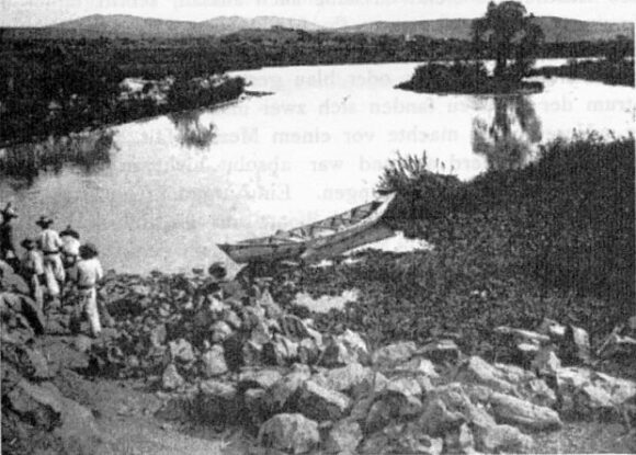
They were very impressed by the grandeur of the Juanacatlan Falls and the book includes several photographs of that area, including the falls themselves, women washing clothes below the falls, and this photo of an unpolluted River Santiago (aka Rio Grande) immediately before the falls.

Wilhelm Schiess: Rio Grande, Juanacatlan (December 1899)

Wilhelm Schiess: Rio Grande, Juanacatlan (December 1899)

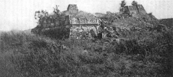
Schiess and his brother had plenty of adventures along the way. Like most other early travelers in Mexico, they made a point of climbing Popocatepetl Volcano, but the brothers went one better than most and photographed the interior of its crater. The two men made several trips to places, such as mines, that were well off the beaten track. In central Mexico, they took the time to explore the ruins of Xochicalco, an archaeological site that even today is often ignored by passing tourists. The main pyramid at that time (photo) had not been restored.

Wilhelm Schiess: Xochicalco (December 1899)

Wilhelm Schiess: Xochicalco (December 1899)

Schiess’ account of their travels in Mexico is essentially a factual, straightforward account of their impressions and what they did, with few digressions, more of a journal than a modern-day travel book. It was well received at the time as an accurate, first-hand account of several little-known parts of Mexico.

A review in the Bulletin of the American Geographical Society claimed that, “His route from Durango across the Sierra Madre to Mazatlan has perhaps never been described before, and the interesting regions he crossed between San Blas and Lake Chapala are not well-known.” It probably is unlikely that the Durango-Mazatlan route had been described in detail prior to Schiess, though (by coincidence) Carl Lumholtz’s Unknown Mexico, which covers some of the same ground, and was based on travels between 1890 and 1900, was also first published, like Schiess’s book, in 1902.

However, the reviewer’s claim that the “regions” between San Blas and Lake Chapala were not well known is a clear exaggeration, since there had been several earlier, detailed, first-hand descriptions of the route from San Blas via Tepic to Guadalajara (and Lake Chapala) on account of this being a major trading and smuggling route during the nineteenth century.

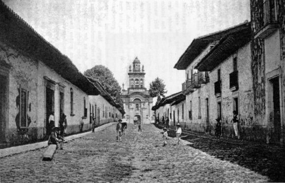
Wilhelm Schiess: Street in Patzcuaro (December 1899)

Wilhelm Schiess: Street in Pátzcuaro (December 1899)

While one reviewer of Schiess’ book lamented the lack of reference to any earlier writers, all agreed that the inclusion of 71 photographs, many of high quality, made the book a valuable addition to the existing literature about Mexico.

Sadly, and presumably because the book was never translated into any other language, Schiess’s work has never received very wide attention. [If any German-speaking reader has time on their hands, and wants to undertake a worthwhile project,… then get in touch!]

Schiess’s account of Mexico is interesting in its own right, but his personal story after the trip to Mexico is just as interesting.

Scheiss’s connection to a Swiss castle

In 1900, shortly after his return to Switzerland, Schiess’s aunt, Mrs. Rosina Magdalena Gemuseus, bought Spiez Castle, on Lake Thun in the Swiss canton of Bern. Parts of the castle date back to the tenth century.

On 28 July 1900, Schiess opened his medical practice – in the castle. Announcing in a local newspaper that his practice was now open at Spiez Castle, with office hours daily in the morning to 11 clock, and with a clinic for eye diseases on Tuesday and Friday mornings, Schiess practiced and lived in the castle for many years, though it is not known which living spaces were used by either his aunt, or the doctor and his wife.

The village of Spiez grew rapidly after 1900. Roads were improved and villagers added a new stone church and many new homes. In about 1906, Dr. Schiess commissioned a firm of Basel architects to build him a large home in the village, to house both his family and his medical office. In other respects, Schiess lived quite modestly, continuing to make his rounds to visit patients by bicycle. Contemporaries described Schiess as a friendly, helpful and keen doctor, who, during the terrible 1918 flu epidemic, worked tirelessly, with no breaks, for several months.

In 1907, Schiess’s aunt sold him some of the outlying castle properties, including the old church, rectory, manager’s house, cherry orchard, vineyards and an area of forest. After his aunt’s death on 3 February 1919, the castle itself passed to Schiess. However, the upkeep was costly, and Schiess soon found himself having to sell valuable objects from the castle to pay for its ongoing maintenance.

By 1922, Schiess was actively looking for potential purchasers. A group of villagers established a foundation with the idea of preserving the castle for future generations. On 1 August 1929, the Spiez Castle Foundation and Schiess agreed terms for the sale of the castle. Barely two weeks later, on 14 August 1929, Schiess died unexpectedly of heart failure.

The castle and gardens first opened to the public in June 1930. The castle rooms are now used for conferences, concerts, exhibitions and other events.

Source:

  • Alfred Stettler. 2004. “75 Jahre Stiftung Schloss Spiez: Die Anfänge” (“75 years of the Spiez Castle Foundation: The beginnings”) in Jahrbuch: vom Thuner und Brienzersee, 2004 (“Yearbook of the lakes Thun and Brienz, 2004). Uferschutzverband Thuner- und Brienzersee.

The evolution of Mexico as a nation

 Books and resources  Comments Off on The evolution of Mexico as a nation
Feb 182016
 

What better way to describe Mexico’s territorial evolution as a nation than via an animated graphic? Fortunately, we didn’t have to do the work ourselves, but found one, showing all of North America, at giphy.com. Sadly, it is no longer active.

The graphic covered the period 1750-2000. Mexico appeared in 1821, when it became formally independent from Spain. The Mexico of 1821 was much larger than today’s Mexico. Its northern border in the 1820s and 1830s reached deep into the modern-day U.S. states of Texas, New Mexico, Arizona, California, Utah and Colorado. These areas remained part of Mexico until after the disastrous 1846-48 Mexico-U.S. war.

At the end of the Mexican-American War (1846-1848) the 1848 Treaty of Guadalupe Hidalgo ceded over half of Mexico’s territory to the USA. A few years later, under the 1853 Gadsden Purchase (Treaty of La Mesilla), northern portions of Sonora and Chihuahua were transferred to the USA. With minor exceptions since, to take account of changes in the meanders of the Río Bravo/Río Grande, this established the current border between the two countries.

Related posts:

The Aqueduct of Padre Tembleque is Mexico’s 33rd UNESCO World Heritage Site

 Mexico's geography in the Press  Comments Off on The Aqueduct of Padre Tembleque is Mexico’s 33rd UNESCO World Heritage Site
Nov 102015
 

Earlier this year, UNESCO added a 16th century aqueduct in Mexico to its list of world heritage sites, bringing the total number of such sites in Mexico to 33.

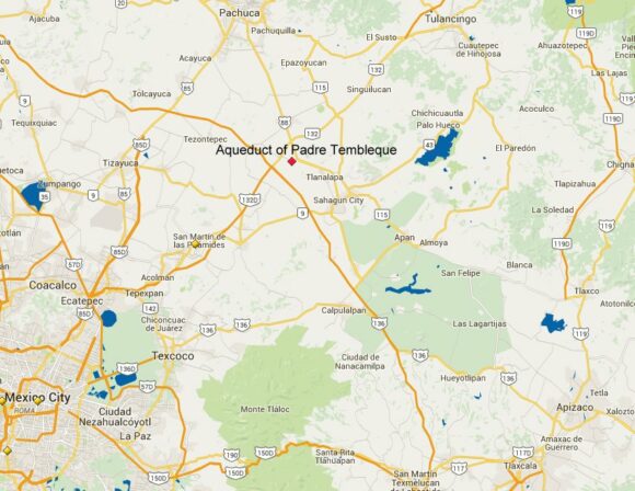
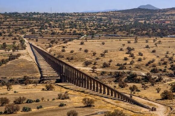
The Aqueduct of Padre Tembleque was constructed between 1554 and 1571. It is named for the Franciscan friar, Francisco de Tembleque, who began the 48-kilometer-long aqueduct, which was built to transport water from what is now Zempoala, Hidalgo, to Otumba in the State of México. The aqueduct connects to an engineered water catchment area, springs, canals and distribution tanks.

Location of Aqueduct of Padre Tembleque

Location of Aqueduct of Padre Tembleque (Source: Google Maps)

The aqueduct was built with support from the local indigenous communities: “This hydraulic system is an example of the exchange of influences between the European tradition of Roman hydraulics and traditional Mesoamerican construction techniques, including the use of adobe.” (UNESCO)

Aqueduct of Padre Tembleque

Aqueduct of Padre Tembleque (Credit: Xinhua/INAH/NOTIMEX)

While much of the aqueduct is at ground level or underground, it crosses over the Papalote River near Santiago Tepeyahualco supported by a graceful series of high arches called the Main Arcade, 67 arches in total, and at one point 39 meters above the river (the highest single-level arcade ever built in an aqueduct “from Roman times until the middle of the 16th century.”)

The Aqueduct of Padre Tembleque is the largest single hydraulic engineering project completed in the Americas during Spanish colonial times and is a worthy addition to the World Heritage list.

For more information:

Related posts


Sep 142015
 

Happy birthday, Mexico! On 16 September 2015, Mexico celebrates the 205th anniversary of its independence from Spain.

Mexican flag

When was Mexico’s War of Independence?

The long struggle for independence began on 16 September 1810; independence was finally “granted” by Spain in 1821.

Want some map-related geographic trivia associated with the War of Independence?

Events in the War of Independence called for an accurate map of Lake Chapala, Mexico’s largest natural lake. The cartographer for this map was José María Narváez, whose major contributions to Mexican cartography in succeeding decades have largely been forgotten.

The first truly national map, compiled in 1857-1858 from a meticulous reconciling of the work of numerous local cartographers, was drawn by Antonio García Cubas. García Cubas did not graduate from university until a few years after completing this map!

Nationalism and the start of Mexico-USA migration, but not in the direction you might think…

Following independence, the rush was on to draw an accurate map of all of Mexico’s territory. Mexico’s boundaries following independence were very different to today. Flows of migrants linking the USA to Mexico at that time were from the USA to Mexico, the reverse of the direction of more recent flows, which have seen millions of Mexicans migrate north looking for work:

Some national symbols are not quite what you might think, either!

The story of the national emblem (used on coins, documents and the flag) of an eagle devouring a serpent, while perched on a prickly-pear cactus, is well known. Or is it?

Why is “El Grito” held on the night of 15 September each year?

In 1910, then president Porfirio Díaz decided that the centenary of Mexican independence should be celebrated in style. One of the reasons why the “traditional” Grito (“shout”) is made on 15 September each year, rather than on the morning of 16 September (when Father Miguel Hidalgo apparently gathered his parishioners in revolt) is because 15 September 1910 happened to be Díaz’s 80th birthday. Why not have one big bash and celebrate both president and country at the same time? Even though the Mexican Revolution broke out later that year (and Díaz was later exiled to Paris), Mexico continues to start its annual independence-day celebrations on the evening of 15 September.

Not to be confused with Cinco de Mayo (5 May)

Many people incorrectly assume that Cinco de Mayo (5 May) is Mexico’s independence day. The Cinco de Mayo has nothing to do with Independence, but everything to do with a famous victory over the French. It commemorates the Battle of Puebla, fought on May 5, 1862. The battle marks Mexico’s only major military success since independence:

Independent country, independent book:

Mexico has come a long way in 200 years, but amazingly, to the best of our knowledge, Geo-Mexico: the geography and dynamics of modern Mexico, is the first-ever book in English focused exclusively on the nation’s varied and fascinating geography.

¡Viva Mexico!

Mexican flag

Sep 102015
 

We have seen numerous examples in previous posts of Mexico’s astonishingly diverse attractions for international tourism. Having succeeded in attracting mass tourism (e.g. Cancún, Ixtapa, Huatulco), Mexico has sought to diversify its tourism appeal by developing niche markets for visitors with special interests, such as cuisine, adventure tourism, historic sites and health-related holidays.

Mexico’s tourism development agency, FONATUR, recently announced it is seeking help from Spain’s leading cultural tourism firm, Paradores de Turismo, to establish a network of Paradores (luxury hotels in historic buildings) in Mexico. Frequent travelers to Spain will be more than familiar with the Paradores system there which offers visitors the chance to stay in some unique historical buildings without sacrificing too many creature comforts.

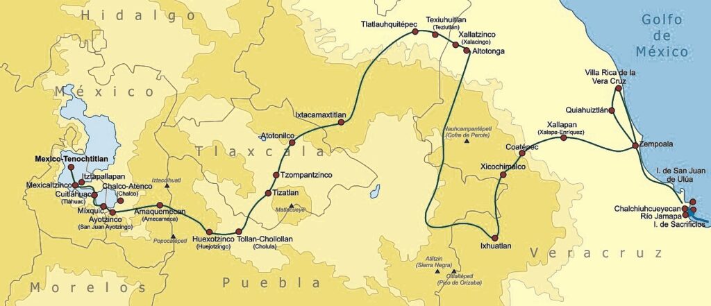
Route followed by Cortés, 1519-1521. Credit: Wikimedia Commons.

Route followed by Cortés, 1519-1521. Credit: Wikimedia Commons. Click to enlarge.

In Mexico, a “History Tourism Plan” is being developed by FONATUR and the Federación de Haciendas, Estancias y Hoteles Históricos de México. In the first stage, an inventory will be compiled of the best existing haciendas, monasteries and other historic buildings that already are, or could be converted to, hotels. At the same time, experts will be discussing which “routes” offer the best combinations and provide most interest to tourists. Routes will be developed to highlight specific themes.

The first route to be proposed is The Route of Cortés, linking properties in five states: Veracruz, Puebla, Tlaxcala, State of Mexico and the Federal District (see map). This is a timely idea given that the 500th Anniversary of the arrival of Cortés and his journey to central Mexico comes in 2019.

Related posts:

Will UNESCO give World Heritage status to Lake Chapala?

 Books and resources, Other  Comments Off on Will UNESCO give World Heritage status to Lake Chapala?
Sep 072015
 

We don’t often champion causes in these pages, but are more than willing to lend our support to a campaign hoping to persuade UNESCO to declare Lake Chapala a “World Heritage” site. The campaign appears to have stalled, and deserves more support.

The following 6-minute video (English subtitles) from 2008 sets the scene for those unfamiliar with the area:

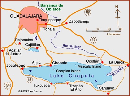
Where is Lake Chapala?

Map of Lake Chapala

Map of Lake Chapala. Credit: Tony Burton; all rights reserved.

Why should Lake Chapala be declared a World Heritage site?

Natural history: it is Mexico’s largest natural lake and home to some unique endemic fauna.

Cultural and historic significance: it is a sacred site for the indigenous Huichol Indian people. Specifically, the southernmost “cardinal point” in their cosmology is XapaWiyemeta, which is Scorpion Island (Isla de los Alacranes) in Lake Chapala.

In the nineteenth century, as Mexico fought for its independence from Spain, Lake Chapala was the scene of a truly heroic struggle, centered on Mezcala Island, between the Royalist forces and a determined group of insurgents. It proved to be a landmark event, since after four years of fighting, an honorable truce was agreed.

At the very end of the nineteenth century, influential families from Mexico and from overseas “discovered” Lake Chapala. For several years, Mexico’s then president, Porfirio Díaz, made annual trips to vacation at the lake. As the twentieth century progressed, the area attracted increasing numbers of authors, poets and artists, many of them from abroad, including such greats as D.H. Lawrence, Tennessee Williams, Witter Bynner, Charles Pollock and Sylvia Fein. (To discover more of the literary and artistic characters associated with Lake Chapala, please see this on-going series of mini-biographies.)

Today, it is the single largest retirement community of Americans anywhere outside of the USA.

Is this enough to qualify Lake Chapala for World Heritage status? I don’t know, but it certainly seems worth a shot!

Posts related to Lake Chapala:

Tourism in the Lake Chapala (Ajijic, Chapala, Jocotepec) and the Lerma-Chapala basin:

Want to read more?

For general introduction and background to this area, see the first eight chapters of my Western Mexico: A Traveler’s Treasury (4th ed, 2013). In the words of Dale Palfrey, reviewing the book for the Guadalajara Reporter, “First published in 1993, the revised and expanded fourth edition of “Western Mexico”… opens with what qualifies as the most comprehensive guide to the Lake Chapala region available in English.“

For a more in-depth account of the history of the Lake Chapala region up to 1910, see my Lake Chapala Through the Ages, an anthology of travelers’ tales. It features informative extracts from more than fifty original sources, linked by explanatory text and comments, together with brief biographies of the writers of each extract. They include some truly fascinating characters… see for yourself!

Both books are available as regular print books, or in Kindle and Kobo editions.

Mar 122015
 

If you really want to learn more about Mexico’s economy and have a few hours to spare, then the free, open, online video course entitled Mexico’s Economy: Current Prospects and History by MRUniversity is the place to go. The lead instructor is Dr. Robin Grier of the University of Oklahoma. In a series of 51 short videos, she provides an outstanding analysis of Mexico’s economic history and current economic issues.

The course summary reads:

Is Mexico the most dynamic economy in Latin America?  After some tough times in the 1980s and 90s, Mexico has emerged as one of the economic leaders of the region.  Where does it stand among other emerging markets and what are its prospects for the future? In this four-week course, we will study the modern Mexican economy, some of the unique elements of development in a one-party, authoritarian regime, and some of the challenges the country faced in getting to this point.

No prior knowledge of economics (or of Mexico’s geography) is needed to follow the clear and concise min-lectures given by Dr. Grier, though many of her main lines of inquiry will be more than familiar to readers of Geo-Mexico.

There is lots of interesting material in these videos. For example, a short lecture under “Social Issues” entitled “Is There A Height Premium in Mexico?” looks at the evidence that taller people in Mexico earn more and have better economic opportunities than shorter Mexicans, before concluding that “each centimeter of height above the average is equivalent to 2% higher wages”. (Note: This video is a great follow-up to our April 2013 post, How tall is the average Mexican?)

The full list of videos in Mexico’s Economy: Current Prospects and History is

  • 1 An Overview of the Mexican Economy
    • Achievements
    • Challenges & prospects for reform
  • 2 Colonial Legacies: Obstacles to Growth after Independence
    • A reversal of fortune
    • Colonial Transportation Part I
    • Colonial Transportation Part II
    • Political Instability After Independence
    • The Economic Effects of the War of Independence
    • Transportation & Infrastructure in the 19th century
    • Slow Financial Development in Early Mexico
    • Law and Economic Development in Early Mexico
  • 3 Development Strategies
    • State-led development: an overview from 1917-1982
    • Commodity Driven Growth before the 1930s
    • Turning Inward: Industrial Policy after the Great Depression
    • Labor Unions and the PRI until democratization
    • What is a maquiladora?    An overview of Pemex
    • The problems of Pemex
    • Pemex’s poor performance
  • 4 Social Issues
    • Fertility and Demographic Change in Mexico
    • Is There A Height Premium in Mexico?
    • Conditional Cash Transfers
    • Migration and its Wage Effects in the US
    • Migration and Remittances
    • Economics of the Drug War
    • Finance, Law & Trust (Mexico)
    • Education Quality in Mexico
    • Education Inequality in Mexico
    • Why is Teaching Quality so Low?
  • 5 Land & Agriculture
    • Land Reform in an Authoritarian State
    • The Economic Life of the Tortilla
    • A Tomato Border Crossing
    • Watermelon Scale Economies
  • 6 The Debt Crisis of the 1980s
    • External Factors of the Debt Crisis
    • Domestic Factors of the Debt Crisis
    • Resolving the Debt Crisis
  • 7 The State Retreats: Reform in the 1980s & 1990s
    • External Factors Behind Reform
    • Privatization Part I: The state loosens its grip
    • Privatization Part 1a: Charges of Cronyism and Corruption
    • Privatization 2: Dealing with the Opposition
    • Privatization 3: Results
  • 8 The Peso Crisis
    • The Mexican Miracle? The Lead-Up to the Tequila Crisis
    • Tequila crisis
  • 9 NAFTA & the Mexican Economy
    • An Introduction to NAFTA
    • The effects of NAFTA on the Mexican economy
    • NAFTA and Mexican Agriculture
    • FDI & NAFTA
  • 10 Modern Mexico
    • Mexico & the Brics
    • Is Mexico the new China?
    • La Reconquista: Mexican direct investment in the US
    • Mexico as an open economy
    • Mexico and the 2008 Global Financial Crisis

The course is an outstanding resource for teachers and students of geography and economics, and worthy of wide use in a range of high-school A-level and IB courses as well as college and university programs.

The Codex Mendoza, a key resource about Aztec times, can now be viewed online

 Books and resources  Comments Off on The Codex Mendoza, a key resource about Aztec times, can now be viewed online
Jan 192015
 

The Codex Mendoza, which we have referred to in several previous posts, can now be viewed via an amazing online interactive resource organized by INAH, Mexico’s National Institute of Anthropology and History, in association with Oxford’s Bodleian Library and King’s College, London.

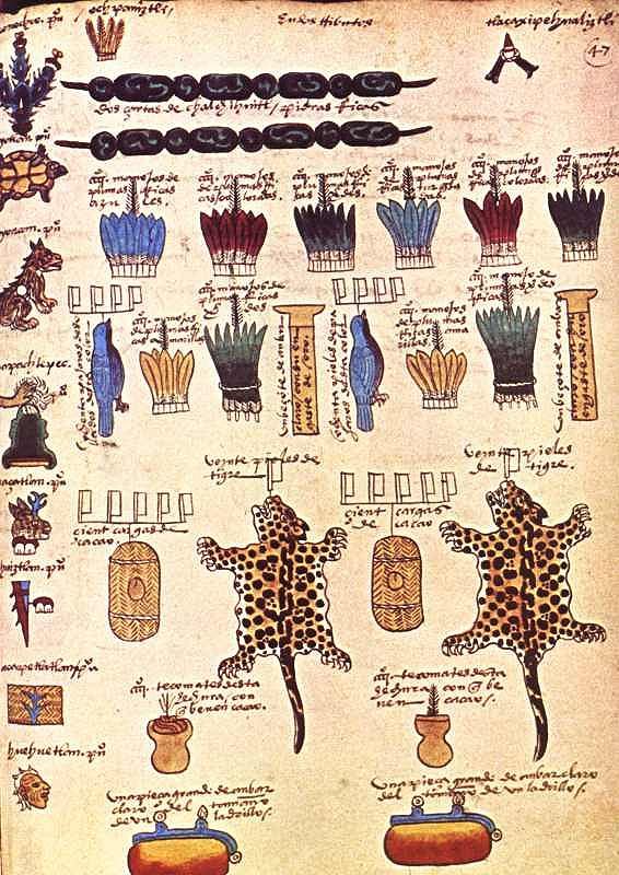
Compiled in 1542, and richly illustrated, the Codex Mendoza is one of the key primary sources from Aztec times. It was completed at the instigation of Spanish viceroy Antonio de Mendoza and provides exquisite details about Aztec history, the expansion of their “empire” and the territorial tributes that they received from every quarter of their dominions. The Codex also chronicles daily life and social dynamics.

Tribute page from the Codex Mendoza

Tribute page from the Codex Mendoza

The interactive online version has images of the entire document and allows viewers to mouse-over the original text for translations into English or modern Spanish. Clicking on individual images offers more detailed explanations and information.

The digital codex can be viewed online, or downloaded through Apple’s App Store as a 1.02-gigabyte app.

The original Codex Mendoza resides in the library of Oxford University.  (The ship carrying it from New Spain (Mexico) back to Spain in colonial times was attacked by French buccaneers. The booty was subsequently divided up, with the Codex eventually reaching the university library.)

The online Codex Mendoza is  a truly amazing resource. Hopefully, some of the other Mexican codices that currently reside in Europe, too also be “virtually repatriated” in the near future, making it much easier for Mexican scholars to consult them.

Related posts:

Mexico’s golden age of railways

 Excerpts from Geo-Mexico  Comments Off on Mexico’s golden age of railways
Nov 302014
 

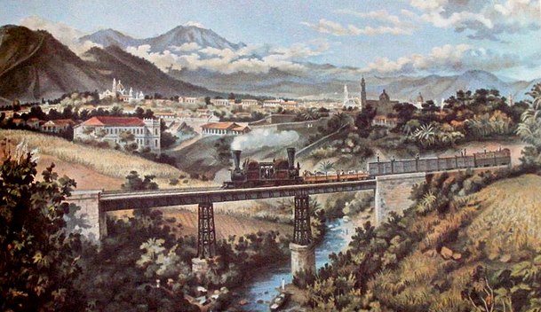
Early concessions (the first was in 1837) came to nothing. By 1860 Mexico had less than 250 km of short disconnected railroad lines and was falling way behind its northern neighbor, the USA, which already had almost 50,000 km. Political, administrative and financial issues, coupled with Mexico’s rugged topography, also prevented Mexico from keeping up with other Latin American nations. Mexico City was finally linked by rail to Puebla in 1866 and Veracruz in 1873.

In deciding the best route for the Veracruz-Mexico City line, Arthur Wellington, an American engineer, developed the concepts which later became known as positive and negative deviation. At first glance, it might be assumed that the optimum route for a railway is the shortest distance between points, provided that the maximum possible grade is never exceeded. Negative deviations lengthen this minimum distance in order to avoid obstacles such as the volcanic mountains east of Mexico City: the Veracruz line skirts the twin volcanic peaks of Popocatepetl and Ixtaccihuatl before entering Mexico City from the north-east. Positive deviations lengthen the minimum distance in order to gain more traffic.

Detail of lithograph by Casimiro Castro of Railway near Orizaba, Veracruz

Detail of lithograph by Casimiro Castro of Railway near Orizaba, Veracruz

At the end of the nineteenth century, during the successive presidencies of Porfirio Díaz, railway building leapt forward. Díaz aggressively encouraged rail development through generous concessions and government subsidies to foreign investors. By 1884 Mexico had 12,000 km of track, including a US-financed link from Mexico City to the USA through Torreón, Chihuahua and Ciudad Juárez. A British company had completed lines from Mexico City to Guadalajara, and from Mexico City via Monterrey to Nuevo Laredo.

Different gauge tracks typified a system based on numerous concessions but no overall national plan. By the turn of the century, additional tracks connected Guadalajara, San Luis Potosí and Monterrey to the Gulf coast port of Tampico. A line connecting the Pacific and Gulf coasts was also completed. Durango was now connected to Eagle Pass on the US border. A second line to Veracruz was constructed, with a spur to Oaxaca. Laws passed in 1898 sought to bring order to the rapid and chaotic expansion of Mexico’s rail system. Foreign concessions were restricted. Subsidies were only made available for the completion of missing links such as lines to Manzanillo and the Guatemala border. Efforts were made to standardize track gauges.

However, the country’s 24,000 km railroad network still had serious deficiencies. There were only three effective connections from the central plateau to the coasts. There were no links from central Mexico to either the Yucatán Peninsula or to the northwestern states of Nayarit, Sinaloa, Sonora and Baja California. The only efficient way to move inland freight from Chihuahua, Torreón, Durango or Ciudad Juárez to the Pacific was either north through the USA or all the way south and through Guadalajara to Manzanillo. The Sonora railroad linked Guaymas and Hermosillo to the USA, but not to the rest of Mexico.

Despite their weaknesses, railroads revolutionized Mexico. The railroads had average speeds of about 40 kph (25 mph) and ran through the night. They were five to ten times faster than pre-railroad transport. They lowered freight costs by roughly 80%. They shrank the size of Mexico in terms of travel time by a factor of between five and ten. They were also much cheaper and far more comfortable than stagecoaches. The estimated savings from railroad services in 1910 amounted to over 10% of the country’s gross national product. Between 1890 and 1910, the construction and use of railroads accounted for an estimated half of the growth in Mexico’s income per person. In addition, the railroads carried mail, greatly reducing the time needed for this form of communication. Clearly, the benefits of railroads far outweighed their costs.

Foreign companies gained mightily from their investments building railroads, which were almost entirely dependent on imported locomotives, rolling stock, technical expertise, and even fuel. But Mexicans also benefited enormously; in the early 1900s over half of the rail cargo supplied local markets and industries. The railroads thrust much of Mexico into the 20th century.

Cities with favorable rail connections grew significantly during the railroad era while those poorly served were at a severe disadvantage. The speed and economies of scale of shipping by rail encouraged mass production for national markets. For example, cotton growing expanded rapidly on irrigated farms near Torreón because the crop could be shipped easily and cheaply to large textile factories in Guadalajara, Puebla and Orizaba. Manufactured textiles were then distributed cheaply by rail to national markets. Elsewhere, the railroads enabled large iron and steel, chemical, cement, paper, shoe, beer and cigarette factories to supply the national market.

On the other hand, most Mexicans still lived far from railroad lines and relied on foot or mule transport while practicing subsistence agriculture. In addition, the cost of rail tickets was prohibitively expensive for many Mexicans; paying for a 70 km (43 mi) trip required a week’s pay for those on the minimum wage. The railroads greatly expanded the gap between the ‘have’ and the ‘have not’ areas of the country. Almost all the Pacific coast and most of southern Mexico did not benefit from the railroads. Such growing inequalities contributed to the Mexican Revolution.

After the Revolution, network improvements were hindered by poor administration, corruption, labor unions and a shift of government priority to roads. The west coast railroad from Sonora to Guadalajara was completed in 1927. The Yucatán Peninsula was joined to the national network in the 1950s and the famous Chihuahua to Los Mochis line through the Copper Canyon was completed in 1961, finally linking Texas and Mexico’s northern plateau to the Pacific Ocean.

In the second half of the 20th century, the rapidly improving road network and competition from private autos, buses and, later, airplanes caused railroad traffic to decline significantly. Freight traffic on the nationalized railroad maintained a competitive advantage for some heavy shipments that were not time sensitive, but for other shipments trucks became the preferred mode of transport. The current system, with its roughly 21,000 km of track, is far less important to Mexico’s economy than it was a century ago.

Related posts:

Nov 232014
 

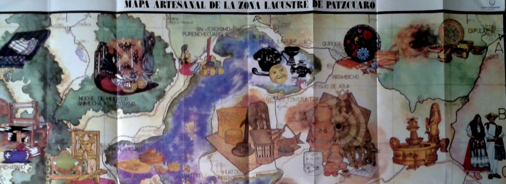
Many of the arts and crafts found in Michoacán date back to pre-Columbian times, but now incorporate techniques and materials that were brought from Europe and elsewhere. Many of the introductions occurred during the time of Vasco de Quiroga (ca 1470-1565), after whom the town of Quiroga, at the eastern extremity of Lake Pátzcuaro, is named.

Visitors to Michoacán area often amazed to discover that towns even only a few kilometers apart have developed completely different handicrafts, and that all the handicraft workshops in any one town seem to focus on making precisely the same items. If one workshop in a town specializes in wooden items, all the neighboring workshops appear to do the same. Just how did these very distinctive spatial patterns come about?

Craft market in Tzintzuntzan, Michoacan

Craft market in Tzintzuntzan, Michoacan

The answer to the oft-asked question, “Why does each town in Michoacán have its own handicrafts?”lies in the history of this area and, in particular, of the efforts almost five hundred years ago of one Spanish priest.

Who was Vasco de Quiroga?

Vasco de Quiroga trained originally as a lawyer. He later took holy orders and arrived in the New World in 1531, already in his sixties. He gained rapid promotion and six years later was appointed Bishop of Michoacán, with the express purpose of trying to clear up the mess left by Nuño Beltrán de Guzmán’s rampage through western Mexico, and to placate the bad feelings of the indigenous Purépecha populace.

Vasco de Quiroga based his approach on the Utopian principles espoused by Thomas More. He established a series of communities in the vicinity of Lake Pátzcuaro, the heart of Purépecha country, improved security, and set up hospitals and schools serving the local people.

Agricultural improvements

Recognizing the importance of agriculture, Vasco de Quiroga introduced European implements and methods as well as new crops, including wheat and other cereals, fruits and vegetables. Perhaps his most noteworthy introduction was the banana. The first bananas to be grown anywhere in Mexico were brought by Vasco de Quiroga from Santo Domingo in the Caribbean and planted in Tzintzuntzan.

Handicrafts

Alongside religious instruction, Vasco de Quiroga organized training in arts and crafts. His efforts quickly won over many of the local people who came to acknowledge that the hostility they had experienced from their first contacts with Europeans was not typical of all the newcomers. The kindly Bishop came to be sufficiently respected by them to be awarded the honorific title of “Tata” (“Father”) Vasco.

The local indigenous Indians had already developed the skills needed for varied ceramics, wood and leather products, copper items, and woven cotton and agave fiber textiles. They also used the local lake bulrushes (tule). Vasco de Quiroga introduced new techniques which allowed the artisans to multiply their production.

To encourage specialization, and limit direct competition between villages, “Tata” Vasco allocated specific crafts to specific places, a pattern that continues to the present. The particular handicraft developed in each village also reflects the availability of local raw materials such as bulrushes needed for mats, or clay for pottery. On account of the fine quality of local clays, the making of ceramics was encouraged in the villages of Tzintzuntzan, Patamban, Santa Fe de la Laguna, Capula and Pinícuaro. Ironworking and locksmithing were introduced in San Felipe de los Hereros; quilting and embroidery in San Juan de las Colcahas, and so on.

Section of tourist map showing some of handicraft towns near Lake Patzcuaro

Section of tourist map showing some of handicraft towns near Lake Patzcuaro

The arts and crafts skills in the villages around Lake Pátzcuaro and elsewhere in Michoacán have been passed down to this day, becoming more finely honed with each successive generation, producing craftsmen who are among the finest in the country. They are responsible for a truly amazing variety of handicrafts, fine art and furniture items.

Among the better known places to seek out particular handicrafts are:

  • Angangueo: woolen items
  • Cuanajo: wooden chests and furniture
  • Erongarícuaro: wooden furniture, earthenware
  • Ihuatzio: petate mats
  • Jarácuaro: palm hats (woven)
  • Paracho: guitars and stringed instruments
  • Pátzcuaro: wool, lacquer work, silver jewelry, toys, etc
  • Quiroga: painted trays and bowls, leather goods, wooden toys
  • Santa Fe de la Laguna: pottery
  • Santa Clara del Cobre: copper items (housewares, miniatures)
  • Tzintzuntzan: wood, pottery, straw decorations and toys
  • Uruapan: lacquer work
  • Zirahuén: wood and cloth dolls

Given this partial listing, is it any wonder that Michoacán is one of the best states in Mexico for finding interesting handicrafts? Happy shopping!

Mexcaltitán, a magical island town in Nayarit

 Other  Comments Off on Mexcaltitán, a magical island town in Nayarit
Nov 102014
 

A short distance north of San Blas, in Nayarit, is a small island called Mexcaltitán. With barely four thousand inhabitants, it would scarcely be expected to have any real link to Mexico City, the world’s greatest metropolis of some twenty million people. But it does, and the link is to be found in the amazing story of the founding in 1325 of the Aztec capital Tenochtitlan, the city which was later conquered and sacked by the Spanish and rebuilt as Mexico City.

The island and village of Mexcaltián, Nayarit

The island and village of Mexcaltián, Nayarit

Historians have long wondered about the origins of the Mexica people, or Aztecs as they later became known. There is virtually no evidence of them before they founded the highly organized city of Tenochtitlan in 1325. Clearly such a civilization cannot just have sprung up overnight. So, where did they come from? Mexica (Aztec) legend tells of a long pilgrimage, lasting hundreds of years, from Aztlán, the cradle of their civilization, a pilgrimage during which they looked for a sign to tell them where to found their new capital and ceremonial center. The sign they were looking for was an eagle, perched on a cactus. Today, this unlikely combination, with the eagle now devouring a serpent, is a national symbol and appears on the national flag.

Map showing location of Marismas Nacionales

Map showing location of Marismas Nacionales

In recent years more and more evidence suggests that Aztlán may be far from mythical and that Mexcaltitán, the island in Nayarit, could be its original site. Ancient codices (pre-Columbian hand-painted manuscripts) prove that the Aztecs’ search for a new place to live was ordained by Huitzilopochtli, their chief god. It began in about AD1111 when they departed from an island in the middle of a lake. Their two hundred year journey took them through present-day Nayarit, Durango, Zacatecas, Jalisco, Michoacán, Guanajuato and Querétaro, and they may well have rested awhile on encountering familiar-looking islands in the middle of lakes such as Chapala and Pátzcuaro.

One of Huitzilopochtli’s alternative names was Mexitli and the current spelling of Mexcaltitán could be interpreted as “Home of Mexitli”, or thus, “Home of Huitzilopochtli”. In fairness, it should be pointed out that if the original spelling was Metzcaltitán (and “tz” often became transliterated to “x” down the centuries), then the meaning would become “Place next to the home of the Moon”.

Whatever the etymology of the name, early codices such as the Boturini Codex show the early Aztecs setting out from an Aztlán surrounded by water, in small canoes. The Mendoza Codex, depicting life in Tenochtitlan, has illustrations of similar canoes and, in both codices, the canoes and method of propulsion by punting show remarkable similarity to the present-day canoes of Mexcaltitán. Visitors to the island still have to undertake a canoe or panga ride to reach the village and it is an intriguing thought that the Mexica/Aztecs were doing exactly the same over eight hundred and fifty years ago.

Further evidence comes from an old map of New Spain. Drawn by Ortelius in 1579, it shows Aztlán to be exactly where Mexcaltitán is to be found today, though perhaps at the time this was largely conjecture.

The street plan of Mexcaltitán, best appreciated from the air, is equally fascinating. Two parallel streets cross the oval-shaped island from north to south, and two from east to west, with the modern plaza in the middle, where they intersect. The only other street runs around the island in a circle, parallel to and not far from the water’s edge. This street may have been the coastline of the island years ago and may even have been fortified against the invading waters of the rising lake each rainy season. Today, as then, for several months in summer the streets become canals, bounded by the high sidewalks each side and Mexcaltitán becomes Mexico’s mini-Venice as all travel has to be by canoe.

This street pattern has cosmic significance. It divides the village into four quarters or sectors each representing a cardinal point, reflecting the Mexica conception of the world. The center can be identified with the Sun, the giver of all life. The Spanish, as was their custom, built their church there, and today the central plaza with its bandstand is the obvious focal point of the community. Small shops, a billiards hall, a modern, well-laid out museum, and an administrative office complete the central area of the village.


Mexcaltitán pen and ink drawing by Michael Eager

Mexcaltitán (pen and ink drawing by Michael Eager from chapter 26 of Western Mexico, A Traveler’s Treasury). All rights reserved.

Low houses, of adobe, brick and cement, line the dirt streets and extend right down to the water’s edge, in some cases even over the water’s edge into the surrounding lake, on stilts. Land on the island is at a premium and, with an ever-growing population, saturation point is very near.

A century ago, the locals turned on some foreigners who came to hunt female egrets, valued for their plumes back in the days when feathers adorned fashionable ladies’ hats. Today, provided only photos are taken, all visitors are welcomed! The villagers celebrate one of the most unusual and distinctive fiestas in all of Latin America. On 29 June each year they organize a regatta which consists of a single race between just two canoes, though naturally hundreds of other pangas are filled with spectators. One of the competing canoes carries the statue of Saint Peter from the local church, the other carries Saint Paul.

Elaborate preparations precede the race. The village streets are festooned with paper streamers and the two canoes are lavishly decorated by rival families carrying on an age-old tradition. The Ortíz family is responsible for St. Peter’s canoe, the Galindo family for St. Paul’s. The statues of the two saints are taken from the church and carried in procession to the boats. A pair of punters has previously been chosen from among the young men of the village for each boat. The punters have been suitably fortified for the contest with local delicacies such as steamed fish, shrimp empanadas, and the local specialty, tlaxtihuile, a kind of shrimp broth. Each boat, in addition to the punters and the statue of the saint, carries a priest to ensure fair play. The race starts from the middle of the eight kilometer long lake after a short religious service in which the priests bless the lake and pray for abundant shrimp and fish during the coming year. Then surrounding spectator canoes, some with musical bands, and others shooting off fireworks, move aside and the race begins.

Nowadays, St. Peter and St. Paul take it in turns to win, most considerate in view of the violence which years ago marred the post-race celebrations when the race was fought competitively. The ceremonial regatta safely over, land based festivities continue well into the night.

A canoe ride around the island takes about 30 minutes and provides numerous photo opportunities as well as many surprises including a close-up view of the island’s only soccer pitch—in the middle of the lake, under half a meter of water. The local children are, perhaps not surprisingly, expert “water soccer” players, a fun sport to watch.

Even if you’re not interested in the island’s past and are unable to see it on fiesta day, your trip to Mexcaltitán will be memorable. This extraordinary island and its village have to be seen to be believed.

The island is reached from the Tepic-Mazatlán highway, Highway 15. There are two alternatives. The northern route is signposted 73 kilometers north of Tepic; it starts with 26 kilometers of paved road crossing swampy paddy fields, followed by 16 kilometers of well-graded dirt road to Ticha, the landing-stage for boats to the island. The drive is through a naturalist’s paradise, teeming with wildlife. The equally scenic southern route begins 57 kilometers from Tepic and is via Santiago Ixcuintla (basic hotels only; don’t miss visiting the center for Huichol Indian culture and crafts) and Sentispac. It leads to the La Batanga landing-stage, and is fully paved.

Note:

This post is based on chapter 26 of my “Western Mexico: A Traveler’s Treasury” (link is to Amazon’s “Look Inside” feature), also available as a Kindle edition or Kobo ebook.

Related posts:

The Magic Town of Tzintzuntzan in Michoacán

 Other  Comments Off on The Magic Town of Tzintzuntzan in Michoacán
Jul 262014
 

Tzintzuntzan, designated a Magic Town in 2012, has two sixteenth century churches, equally ancient olive trees, a craft market specializing in straw goods and ornaments, plus an archaeological site which was the capital of the not inconsiderable Tarascan Empire.

The Tarascan Empire

The Tarascan Empire, contemporaneous with that of the Aztecs, stretched westwards as far as the shores of Lake Chapala, with sporadic contacts into the Sayula lake area, and to the east as far as present-day Zitácuaro. The Tarascans spoke Purépecha, and today the local indigenous people prefer to be called Purépecha. The term “Tarascan” is more properly reserved for their ancestors and their pre-Columbian empire.

“Tzintzuntzan” is an onomatopoeic Purépecha rendering of the sound made by a hummingbird. The ceremonial center was still fully active when the Spanish arrived. Tarascan buildings were constructed mainly of wood. Only the basements were normally built of stone and today, therefore, it is only these basements or yácatas that remain. Some of the cut stones which cover the rubble-filled interiors of the yácatas are ornamented with rock carvings.

The scale of earth-moving involved in constructing the temples is remarkable. The entire 425-meter-long platform is man-made. On it were built five yácatas, on the tops of which would have been wooden and thatch structures serving as shrines. The semi-circular shape of these yácatas suggests that they were built to honor the god of the wind, Ik. The Tarascan ceremonial centre commands a magnificent view over the lake, whose waters would have been lapping at the platform’s base during some rainy seasons. The area behind the yácatas, next to the village soccer pitch blazes with color during the wildflower seasons of late spring and early autumn. The archaeological site has a small, modern museum.

The Tarascans had a mixed economy, collecting fruits and forest products, fishing and undertaking agriculture, complete with terracing and irrigation. Some archaeologists have argued that many of the pre-Columbian peoples, dependent on the natural world for their immediate survival, were very ecologically-conscious. However, in this area, evidence from rates of lake sedimentation now suggests that maybe they weren’t quite so environmentally-aware after all. It seems that erosion rates were already on the rise by the time the Spanish arrived, suggesting that native agriculture was almost certainly not sustainable. Following the introduction of European diseases, the decline in population (and agricultural workforce) prompted a further increase in erosion rates as soil conservation methods could not be maintained. Erosion and sedimentation were exacerbated by the nineteenth and twentieth century deforestation of surrounding hills.

Spanish churches

Tzintzuntzan monastery and church. Artist: Mark Eager. All rights reserved.

Tzintzuntzan monastery and church. Artist: Mark Eager. All rights reserved.

The Spanish destroyed the Tarascan temples, carting off many of the stones to build Catholic churches in their new village. Observant visitors to the beautifully-proportioned patio of the former monastery beside the main church will spot petroglyphs on some of the walls there which betray the stones’ earlier placement in the yácatas. This building, decorated with fine old colored frescoes depicting Franciscan lore, and with parts of its original wooden roof still intact, houses the office of the parish notary and is not always open to the public.

There are other peculiarities here, too, which say much for the realities of sixteenth century Spanish monastic life. When the monastery of Tzintzuntzan was built, two churches were constructed, one for the monks’ private use and the other for the lay Third Order. These two churches, only a few steps apart, are about as different as can be, given that they are of similar age. The monks’ church, beautifully restored following an arson attack, is light and airy; the Third Order church is dark, gloomy and oppressing. Both, in their own way, are awe-inspiring. To one side of the Third Order church is a complete-immersion font, shaded by two tall trees.

Ancient olive trees

In the large atrium in front of the monastery are a sixteenth century cross and the bent and twisted tree trunks of some of the oldest olive trees in Mexico, brought by special request from Spain for the express purpose of providing the monks with one of their accustomed foods. They are thought to be more than four hundred and fifty years old.

Handicraft market

Tzintzuntzan’s handicraft market is a cornucopia of straw work in every conceivable color, design and size, which make ideal Christmas decorations or gifts. Also on sale are elaborately carved wooden beams, and examples of the many different local pottery styles including the Ocumicho devil-figures and strange green pineapples as well as finely detailed, hand-embroidered scenes of village life.

How to get there:

Tzintzuntzan is about twenty minutes drive from Pátzcuaro.

Source:

This post is based on chapter 32 of my “Western Mexico: A Traveler’s Treasury” (link is to Amazon’s “Look Inside” feature), also available as either a Kindle edition or Kobo ebook.

Raymond Craib’s “Cartographic Mexico, a history of state fixations and fugitive landscapes”

 Books and resources  Comments Off on Raymond Craib’s “Cartographic Mexico, a history of state fixations and fugitive landscapes”
Jul 192014
 

This book by Raymond Craib (Duke University Press, 2004) is one-of-a-kind. Craib combines archival analysis of mainly 19th century documents with perceptive comments on the relationships between history and geography in Mexico from the mid-19th century until about 1930.

craib-coverIn “Cartographic Mexico, a history of state fixations and fugitive landscapes”, Craib emphasizes the significance of map-making in post-Independence Mexico as a means towards furthering nationalism and as a development tool. He traces the changing motives of map-makers, focusing especially on the key area of Veracruz-Puebla which served as Mexico’s main gateway to Europe for centuries.

Craib considers why certain place names acquired more prominence than others, and examines a case study of a mining area where the granting of water rights hinged on precisely where a particular river flowed, and which tributary had which name, a case where cartographic ‘proof’ proved to be impossible and where a pragmatic solution was required.

This is an important study, with meticulous footnotes and bibliography.

“Cartographic Mexico, a history of state fixations and fugitive landscapes” is available via amazon.com

(Note: This short review was first posted on sombrerobooks.com)

Other books reviewed on Geo-Mexico.com:

The Magic Town of Tacámbaro in Michoácan

 Other  Comments Off on The Magic Town of Tacámbaro in Michoácan
Jul 052014
 

The interesting, but unpretentious, town of Tacámbaro in Michoacán was awarded Magic Town status in 2012. The town has a population of around 26,000 and is located at an elevation of 1650 meters above mean sea level on the edge of Mexico’s tierra caliente. Its full formal name is Tacámbaro de Codallos, so-named to honor a Venezuelan who defended federalism in the early years of Mexico’s Independence.

tacambaro

Among the tourist highlights of this Magic Town, set in the midst of stunning mountain scenery, are:

  • The town center. Despite a serious town center fire a few years ago, there is plenty to see here, including an old chapel around the corner from the main church.
  • The Hotel-Restaurant El Molino (The Mill) located near the entrance to the town. The main restaurant building is a converted, museum-piece nineteenth century flour mill, complete with grinding wheels. Simply and artistically decorated and furnished, this hotel-restaurant has an excellent fixed-price mid-day meal (comida) with subtle sauces and a varied menu.

Though not normally open to the public, a few minutes outside Tacámbaro, is the private hacienda-studio of master printer Juan Pascoe. Pascoe produces superb quality, limited collectible editions, using one of the oldest printing presses still in operation anywhere in the world: an R. Hoe Washington handpress dating back to 1838.

Historical links to Belgium

One of the more curious incidents in local Tacámbaro history is the so-called “Pardon of the Belgians” in 1865.

Belgian forces on the side of Maximilian, under Major Tydgat, were under siege in Tacámbaro on April 11, 1865. They chose to take several Republican families hostage, including the wife and three children of Nicolás de Régules, the Liberal general who was in charge of the Juarist (Republican) forces attacking the city. When Republican lieutenants realized that the hostages included the family of their general, they first requested orders for their troops to change course and avoid attacking the city, but the general answered, “Men, to your posts! Everyone has to do his duty. The Fatherland comes first!”

Later in the ensuing fighting, in a last ditch effort to prevent defeat, the Belgians produced the family of de Régules and placed them directly in the line of fire. Even that did not stop de Régules who ordered his troops to keep fighting and to take as many prisoners alive as possible. After the battle was over, de Régules had taken more than 300 prisoners, but had not taken revenge for the killing of his family. What a noble act!

The events in Tacámbaro are commemorated by monuments in two Belgian cities: Beverlo and Audenarde.

How to get there:

Tacámbaro is about an hour’s drive from the city of Morelia, the capital of Michoacán state. Follow the Morelia-Pátzcuaro highway westwards, exiting at Tiripetío (“place of gold”), where a former Augustinian college of higher studies, one of the earliest in the Americas, founded in 1537, has been restored and now houses an invaluable historical archive. From Tiripetío, follow signs for Villa Madero, and then Tacámbaro.

New York Public LIbrary online historical maps of Mexico

 Books and resources, Maps, Mexico's geography in the Press  Comments Off on New York Public LIbrary online historical maps of Mexico
Jul 022014
 

A few months back, the New York Public Library (NYPL) announced that it was placing high resolution scans of more than 20,000 cartographic works online. The NYPL also asserted that it believed that “these maps have no known US copyright restrictions” and that it “is distributing these images under a Creative Commons CC0 1.0 Universal Public Domain Dedication.”

The maps can be viewed and downloaded via the New York Public Library’s Digital Collections page, and the NYPL Map Warper.

Naturally, this piqued Geo-Mexico’s interest, and we spent several enjoyable hours browsing the various maps included in this online treasure-trove that have some relation to Mexico. A search for “Mexico” yielded 36 maps, though this number included many that depict New Mexico.

seller

This 1679 map “Mexico, or, New Spain” (above) comes from “Atlas minimus, or, A book of geography : shewing all the empires, monarchies, kingdomes, regions, dominions, principalities and countries, in the whole world”, by John Seller.

Far more detailed, and a more recognizable shape emerged by 1713, with the publication of Mexico, or, New Spain : divided into the audiance of Guadalayara, Mexico, and Guatimala, Florida, from “System of geography with new maps”.

Carey's 1814 map.

Carey’s 1814 map.

This 1814 map “Mexico of New Spain” (above) is part of “Carey’s general atlas, improved and enlarged : being a collection of maps of the world and quarters, their principal empires, kingdoms, &c.”

From the mid-nineteenth century, the maps become very much like modern-day atlas maps. For example, this 1876 map, “Mexico; Mexico to Vera-Cruz; The Isthmus of Tehuantepecfrom the “New illustrated atlas of Dutchess County, New York. / Compiled & drawn from personal examinations, surveys etc. under the personal supervision of O.W. Gray & Son and F.A. Davis, and published under the superintendence of H. L. Kochersperger”.

Related posts:

Jun 022014
 

This engaging book analyses the historical geography of the port of San Blas, on Mexico’s west coast, and its hinterland which includes the small city of Tepic, the state capital of Nayarit. This area held immense importance during colonial times, was one of the main gateways for trade and influence peddling during the nineteenth century, before lapsing into relative obscurity at the end of the that century, and into the twentieth century. The tourism industry has sparked a mini-revival but none of the many grandiose plans for this coast have even been brought fully to fruition.

richter-coverThe Camino Real in Richter’s title is actually a branch from the Camino Real de Tierra Adentro (The Inland Royal Road, the spine of the colonial road system in New Spain). During colonial times, this linked the inland city of Guadalajara to Tepic and thence San Blas, though the modern highways uniting these places no longer follow the same route.

Robert Richter has known this area personally for decades, and his intimate knowledge of the local geography shines through. The book combines his own personal experiences with intensive historical research, both in the library and on the ground. Richter’s objective is to pin down the precise route of the Camino Real, and then find every remaining vestige of it that he can on the ground.

In reading the story of San Blas and the Camino Real, readers are treated to a dazzling array of insights into what made this area tick for so long before subsiding into something of a backwater. This branch of the Camino Real, from Guadalajara to San Blas, played a key role in the history of Western Mexico, and saw everything from pirates and adventurers to soldiers, priests and smugglers.

As Richter points out, “The Matanchen Bay-San Blas region grew in geographic and strategic importance to become the most important Pacific seaport between Guayaquil, Ecuador, and San Francisco, California, in the 1830s, a major international way station for both legal and contraband trade between an ungovernable Mexico and the rest of the world.”

This growth continued and, “In the 1850s, the cultural, economic, and political events roiling all along the Camino Real from San Blas to Guadalajara, especially in the mild sierra valley surrounding the city of Tepic, spawned a new regional identity, and eventually, a new political entity—the Mexican state of Nayarit.”

Richter tells his story with passion and it is impossible not to be drawn into the narrative and share his excitement as he sets out to find “missing” sections of the Camino Real, accompanied by a motley crew of secondary characters. To what extend does he succeed? Sorry, no spoilers here!

Inevitably, the past merges with the present and the future. What began as a seemingly straightforward historical geography becomes at turns a travelogue, journal of fieldwork and short essay about the sustainability of economic development along this coast. Richter is clearly not against change, but argues strongly that local tourist development in the future must take account and respect the region’s ecology, its history and its culture.

As the back cover blurb aptly states, “To explore Nayarit’s wild and gorgeous geography, trying to site the ancient Camino Real, is to stumble over another road running toward the state’s future economic development as part of the Mexican Riviera.”

This book should be of interest to geographers everywhere. It serves to prove that historical geography need not be dull and stuffy but can be made relevant, exciting and even entertaining, at the same time as it offers us valuable insights into possible futures.

One minor plea: please add an index when the second edition of this book is prepared!

Search for the Camino Real, a history of San Bad and the road to get there” is one of several books by Richter centered on the fading coastal village culture of Nayarit and the Mexican Riviera. His adventure novel, “Something like a Dream” (Oak Tree Press, 2014) is an especially entertaining read, with a lively plot and well-described settings ranging from the tourist resort of Puerto Vallarta to Nayarit fishing villages and tiny Huichol Indian settlements high in the Western Sierra Madre.

Map of the beaches of Colima, Jalisco and Nayarit, Mexico shows the location of all the key places mentioned in Richter’s books.

Related posts:

The Magic Town of Jiquilpan in Michoacán

 Other  Comments Off on The Magic Town of Jiquilpan in Michoacán
Apr 102014
 

For a small Mexican town of somewhat nondescript architecture, Jiquilpan de Juárez, in Michoacán, has considerable claim to fame, well deserving of its Magic Town status. Jiquilpan is the birthplace of two Mexican Presidents, who played pivotal roles in national affairs, and several distinguished artists. Its unprepossessing exterior appearance offers no hint of the important works of art—including sculptures and a singular mural—which are to be discovered in the town.

The first former President associated with the town is Anastacio Bustamante, who had the distinction of being President three times 1830-32, 1837-39, 1839-41). In the interim between his first two governments, Mexico was forced to cede a large part of its territory, including Texas, to the USA. Bustamante, considered one of the more honest nineteenth century politicians, seized power for the first time in 1830, overthrowing Vicente Guerrero. He was in turn overthrown by Santa Anna in 1832, and fled to England. On resuming office in 1837, after the rather unsavory incidents which robbed Mexico of Texas, Bustamante immediately faced the “Pastry War” crisis.

The Pastry War began when Mexico refused to pay compensation for damages to a pastry shop, owned by a Frenchman in Mexico City. The shop had allegedly been looted during riots in 1828. Ten years later, the French government used this pretext, and other losses which had occurred at the same time to other French property, to demand 600,000 dollars in damages from the Mexican government of Bustamante. The French also sought a preferential trading agreement with Mexico. Bustamante considered the claim for looted pastries to be preposterous and refused either to pay, or to consider the trade agreement. Outraged, the French brought up a fleet from the Caribbean island of Martinique and blockaded Veracruz. Seven months later, the French added a further 200,000 dollars to their demand to cover the costs of the blockade. Bustamante finally gave in and paid in full, whereupon the French fleet sailed off.

The second former President associated with  Jiquilpan is Lázaro Cárdenas, born in the town on the 21st May, 1895. As national President (1934–40), he presided over a massive agrarian reform program and in 1938 nationalized the railways and the oil industry. He was the last President to be held in sufficient esteem to occupy important ministerial posts including Defense Secretary after the end of his term as President.

jiquilpan-sm2On Jiquilpan’s main street, appropriately named Avenida Lázaro Cárdenas, are the library and the town museum. During Lázaro Cárdenas’ presidency, a nineteenth century church in Jiquilpan was converted to a library and embellished with two impressive works of art. The new door of the library, in which are sculpted the heads of 22 of the most outstanding figures of the early twentieth century, was designed by Guillermo Ruiz. It is a beautiful tribute to the greatest thinkers and scientists of the time (Edison, Marti, etc.).

The murals decorating the interior of the library were painted by an even more prominent figure in the history of Mexican art: José Clemente Orozco, one of the famous “Big Three” of Mexican Muralism, alongside Diego Rivera and David Alfaro Siqueiros. Orozco painted, literally singlehandedly (having lost his left hand in a childhood accident) a series of sketchy black-and-white murals depicting political parties and revolutionary Mexico on either side of the former nave and an unusual and striking full-color, nationalistic mural known as “A Mexican Allegory”.

The modern Jiquilpan museum, east of the town center beyond the very friendly Hotel Palmira, includes a collection of archaeological pieces unearthed from a nearby shaft tomb. In addition to the archaeological pieces, the museum houses the Centre for Studies of the Mexican Revolution. Even non-Spanish speakers can gain insights into the turbulent and complex times that comprise the Mexican Revolution by looking at the extensive photographic exhibition on the museum’s first floor. The exhibition details the life and works not only of Lázaro Cárdenas but also of other key figures in twentieth century Mexican politics including General Francisco Múgica, who was in the group which proposed for inclusion in the Constitution of 1917 (still current today) Article 27, which encompassed agrarian reform and land redistribution, and Article 123 which dealt with the rights of workers, including an eight-hour day and guaranteed minimum wages. The museum in Jiquilpan is a fitting tribute to these much revered politicians.

Moving away from politics and towards the arts, Jiquilpan was the birthplace of artist Feliciano Béjar, who passed away in 2007, and received national acclaim for his inspiring sculptures, painting and weaving. Rafael Méndez, arguably the world’s greatest ever trumpet virtuoso, was born into a musical family in Jiquilpan and later moved to the USA. His legendary technique and tone have never been equaled. Jiquilpan hosted an international trumpet festival named for him in 2011.

Elsewhere in Jiquilpan are a statue of Christ on the Cross, said to date from the times of Emperor Charles V (now in San Francisco church), and a fountain sculpted by Francisco Eduardo Tresguerras, Mexico’s most famous nineteenth century sculptor and architect. This fountain was originally on the El Cabezón hacienda, owned by the Cañedo family, in Jalisco, but the family later gave it to Lázaro Cárdenas to beautify his native town. Known as “The Fisherman’s Fountain” (Pila de los Pescadores), it is a few blocks from the main plaza. Another, newer fountain on the plaza, “La Aguadora” (The Water Carrier), commemorates the first anniversary of the nationalization of the oil industry.

The ancient hieroglyph for Jiquilpan, from pre-Columbian times, is a horizontal line of earth with two indigo plants above it, linking the town to the color blue. One of Jiquilpan’s most famous poets, Ramón Martínez Ocaranza, also linked his birthplace to the color blue, christening it, “the city of jacarandas”, a tag that quickly caught on and is still used today. Anyone who drives through the town during jacaranda season (February–March) will certainly agree that the tall trees  with their lavender-blue blossoms bordering the main avenues are a magnificent sight.

Note: This is a lightly edited excerpt from chapter 6 of my Western Mexico: A Traveler’s Treasury (Sombrero Books, 2013)

Related posts:

Jan 162014
 

“Holiday in Mexico” is a collection of essays relating to the history of tourism in Mexico. The dozen authors involved are primarily academic historians, but also include a journalist. While the writing style is somewhat varied, this in no way detracts from the overall high quality of the contributions.

As Dina Berger and Andrew Grant Wood, the book’s editors, point out in their introduction, Mexico’s dilemma as regards tourism has always been to “reconcile market demand with a desire for national sovereignty” (p. 1). Tourism may stimulate the economy but can also have adverse environmental, social, and cultural consequences. Tourism promoters have always sought to “package” Mexico in a way that will attract tourists. The tourism sector’s portrayals of Mexico are inevitably subjective and seek to influence the perceptions of potential visitors.

The book’s 14 chapters (including the introduction) span 3 time periods:

  • 1840s-1911
  • 1920-50
  • 1960-present

and examine three main themes:

  • how Mexicans promoted and imagined their country and culture
  • the political lenses through which Mexicans and tourists have interacted with each other
  • the advantages and disadvantages of tourism

1840s to 1911

Two chapters look at the early history of tourism in Mexico. Andrea Boardman links the early days of American tourism in Mexico to the US soldiers who entered Mexico during the Mexican-American War. Among other achievements, American soldiers climbed Mexico’s highest peak, El Pico de Orizaba, though they were certainly not the first foreign nationals to do so. The accounts written by soldiers helped the American public appreciate that Mexico was worth exploring. Visiting Mexico became easier once the major railway lines had been completed at the end of the nineteenth century.

Christina Bueno offers a detailed look at the contested reconstruction of Teotihuacan, the earliest major archaeological site to be opened for tourism, its “restoration” timed to coincide with the celebrations for Mexico’s centenary of independence. Cultural and historical tourism have remained important aspects of tourism in Mexico ever since. Such tourism simultaneously stresses the significance of indigenous culture while portraying the nation as “modern” and “forward looking”.

1920-60

Five chapters of “Holiday in Mexico” look at the formative period of tourism development in Mexico that began shortly after the start of the Mexican Revolution in 1910.

cover of holiday in mexicoAndrew Grant Wood shows how business leaders in the port of Veracruz were able to reposition the city, changing its image from an insalubrious and unsafe city into a haven for cultural activities, music and dance, centered on annual Carnival celebrations.

Dina Berger looks at tourism, diplomacy and Mexico-USA relations. Mexico’s active promotion of its national progress (such as modern highways), democracy and friendliness coincided with a period when the USA pursued its Good Neighbor policy and Panamericanism (such as the construction of the Pan American Highway).

Eric Schantz’s essay focuses on postwar tourism in Baja California’s border zone, and considers the impacts of gaming, racing, prostitution and the growing tourism entertainment industry. Many of those crossing the border to partake in these activities were, strictly speaking, “visitors” rather than “tourists”, since they remained less than 24 hours, but they had a massive influence on the economy of some border cities.

In the next chapter, “Fun in Acapulco? The Politics of Development on the Mexican Rivera,” Andrew Sackett weaves a carefully-crafted narrative that encompasses Acapulco cliff divers, Hollywood movie stars, state intervention, poor ejido farmers being dispossessed of their land, and the capriciousness of resort developers. This is possibly the strongest chapter in the book from a geographical perspective, though Sackett overstates the significance of a 1946 map of the city, since all maps are perceptual statements and necessarily simplify the landscape and select the most appropriate points of reference for their intended audience.

Lisa Pinley Covert then looks at how San Miguel de Allende’s tourist industry developed from a combination of local, national and international factors and players. In this case (unlike Acapulco) local efforts were preeminent in establishing the city’s reputation as a center for cultural tourism. Interestingly, no distinction is drawn in this chapter between the impacts of “tourists” and the impacts of the longer-term, non-tourist foreign residents that now comprise a distinctive segment of the city’s population.

1960-present

The final five chapters have greater contemporary relevance. Jeffrey Pilcher gives an engrossing account of how culinary tourism emerged, of how restauranteurs created “authentic” Mexican cuisine, a kind of “gentrification” of Mexican food. This account supports the view that cultural imperialism has not led to the food homogenization of North America, but, on the contrary, has led to varied, glocalized responses including innovatory regional and local cuisine.

M. Bianet Castellanos looks at the lesser-known face of mass tourism in the centrally-planned FONATUR resort of Cancún: the many service workers who migrated from nearby indigenous communities, and their perceptions of the resort and its tourist industry.

Adopting a national viewpoint, Mary K. Coffey examines how federal government policies in the past decade or so have sought to promote Mexico’s artistic and folk art culture as a powerful magnet for tourism. To remain competitive on the world stage, and counteract the impacts of events elsewhere (such as 9/11), Mexico’s tourism sector needs to continually reinvent itself. This is an excellent example of how changing policies and rhetoric can help keep Mexico in the world tourist spotlight.

In looking at Los Cabos, another centrally-planned resort, Alex M. Saragoza emphasizes how it was designed specifically to appeal to wealthy US tourists, hence its emphasis on golf courses, and its grandiose plans (now scaled-back) for the “Escalera Náutica”, a network of marina resorts.

The final essay, by travel writer Barbara Kastelein, looks at some of the forces behind the development of tourism in three contrasting locales: Acapulco, Oaxaca and Amecameca, considering some of the broader aspects including race, gender, and class dynamics.

The geographical coverage of “Holiday in Mexico” is quite broad but certainly not comprehensive. The use of case studies allows the authors to explore the many subtexts in depth, but it may be that some of the insights arrived at fail to hold up when a regional or national scale is considered.

The book certainly provides plenty of ideas worth further discussion, along with thoughtful analysis of different stakeholders, different types of tourism and their relative merits. The authors do not shy away from looking at the impacts of the massive socioeconomic gaps between tourists and their Mexican hosts, or of the corruption that has unfortunately accompanied many tourism developments in Mexico.

If I have one minor reservation about this book, it is that it is overly US-centric. The history of tourism in Mexico deserves a more nuanced approach, one in which the role of European and Latin American tourists is also closely examined. This clearly opens up many possibilities for future research.

Dina Berger and Andrew Grant Wood (eds). 2010 “Holiday in Mexico: Critical reflections on tourism and tourist encounters.” Duke University Press.

Related posts:

Example of a sixteenth century map

 Other  Comments Off on Example of a sixteenth century map
Dec 072013
 

In the mid-sixteenth century, the Spanish Court was determined to acquire accurate information about everything being encountered in New Spain. This led to a series of censuses and accounts, including the Relaciones geográficas (Geographic Accounts).

The basis for the Geographic Accounts was a 50-question survey, sent to New Spain in 1577. The authorities in each administrative center were instructed to call a meeting of the “Spaniards and other natives in the district”, to find out everything they could about the area’s geography, people and history.

Of the 191 known responses to the 1577 questionnaire, 167 have survived in archives to the present day. Most of the original responses are housed in Spain, in either the Archivo General de las Indias in Seville or the Real Academia de la Historia in Madrid, while a further 43 responses form part of the Benson Latin American Collection in the University of Texas library in Austin. (The library’s webpage about the Relaciones geográficas has several links to images of sample pages and maps).

Map of Zempoala area from the Relaciones Geográficas

Map of Zempoala area from the Relaciones Geográficas (1577)

The accounts contain a wealth of information about population, relief, flora, fauna, economic activities and lifestyles. Some also include maps of the areas being described. However these early maps do not follow modern conventions in terms of having a uniform scale across the area being shown, or an orientation that is consistent in terms of compass directions. They are pictorial maps, where the scale varies across the map, and where areas are delimited, or places are linked, without apparent regard for direction.

One such map (see image above) depicts the area around Zempoala (Hidalgo). This is analyzed by Barbara E. Mundy, Associate Professor of Art History at Fordham University, in an online article, Mapping Babel: A Sixteenth-Century Indigenous Map from Mexico, published in The Appendix, a “journal of narrative and experimental history”. In the article, Mundy provides a detailed, step-by-step account of the map, with lots of additional related images and information.

Detail of map, showing Tepemayalco

Detail of map, showing Tepemaxalco

Mundy’s analysis reveals several “acts of translation” that have been made by the indigenous artist(s) presumed to be responsible for drawing the map.

For example, the artist(s) made the Spanish paper provided for the map more closely resemble its indigenous counterpart (bark paper), by joining sheets together to create the size they wanted for the map. In addition, unlike modern maps where the viewer is essentially static, with the map details arranged around them, indigenous maps demand changes of perspective, mobile viewers, who have to reorientate themselves depending where they are on the map in order to see things clearly.

Many of the images are a translation, perhaps of similar European images. For instance, like most towns on the map, Tepemaxalco is shown with “a conventional sign for a Christian chapel: a small building drawn in perspective with one side marked by a shadowing grey wash, topped with belfry and cross.”

The map also links the pictograph for each place name to its name written in alphabetic script. “The pictograph for Tepemaxalco (see image) registers some of its Nahuatl components: tepetl, ‘hill,’ maitl, ‘hand,’ xalli, ‘sand’ and co, ‘place of.’ Below, the name is written in alphabetic script, probably introduced by the Franciscans who evangelized this region.”

The dominant pictogram on this map is that for Zempoala (written “Cenpoballa” on the map). Mundy offers an interesting interpretation of this pictograph, which we hope to examine further in a future post.

Further reading

Barbara E Mundy. 2001. The Mapping of New Spain: Indigenous Cartography and the Maps of the Relaciones Geográficas.

Related posts: