Apr 252016
 

Cuatro Ciénegas (“Four Marshes”) is a city and municipality in the northern border state of Coahuila. Founded in 1800, it has some historical significance, since it was the birthplace of Venustiano Carranza, Mexico’s president from 1915 to 1920.

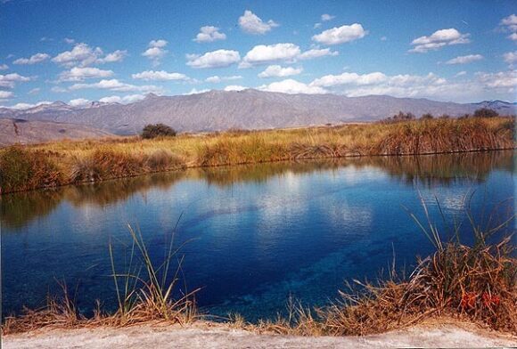
The natural nearby “marshes” are highly unusual. Situated in an arid region (part of the Chihuahuan desert), they include several natural springs that feed more than 200 small ponds and wetlands. Some of the water supporting these unique wetlands, which cover an area of 84,400 hectares, is believed to be more than 200 million years old. The wetlands are an integral part of the UNESCO-designated Cuatro Ciénegas biosphere reserve. The reserve is home to several endemic organisms, including microorganisms such as cyanobacteria that historically helped produce oxygen for the Earth’s atmosphere. The area is considered “a living laboratory of evolution and the origin of life”.

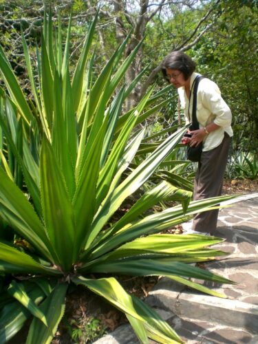
Cuatro Ciénegas. Credit: Nancy T. Wilson (MexConnect)

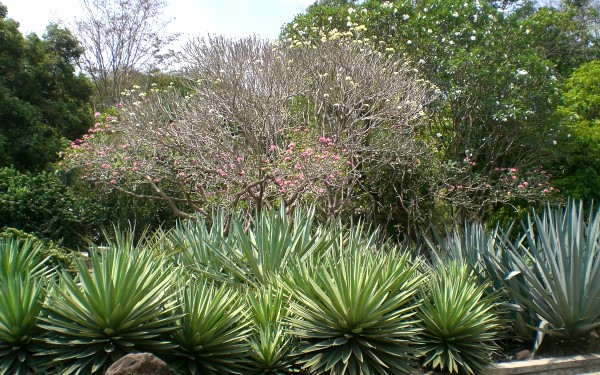
Cuatro Ciénegas. Credit: Nancy T. Wilson (MexConnect.com)

Human activities in the surrounding area have led to severe water stress on the Cuatro Ciénegas marshes. The basin’s average natural recharge rate (replenishment rate) is about  25 million cubic meters a year, but the average yearly extraction rate, almost all for agricultural use, is close to 49 million cubic meters.

Water stress may be exacerbated in coming years by climate change, which may reduce rainfall while simultaneously increasing evapotranspiration.

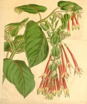
Scientists have also identified five particular exotic (introduced) species that pose a significant risk to the long-term quality of the Cuatro Ciénegas wetlands. Whether naturally or deliberately introduced, these five species – African jewelfish, blue tilapia, giant cane (giant reed), Guatemalan fir and tamarisk (salt cedar) – threaten to displace endemic species and change natural nutrient flows and food chains. Guatemalan fir and tamarisk soak up water as they grow, further drying out the marshes (though, eventually, when little water is left, they will die off). The blue tilapia carries parasites that can jump to local species that have no resistance to them. The African jewelfish occupies the same ecological niche as the endemic mojarra and gradually replaces it.

Mexico’s Comision Nacional de Áreas Naturales Protegidas (CONAMP), is now working with the Mexican Fund for Nature Conservation (FNCN) and the Canadian government agency Parks Canada to develop and implement a control and eradication program to tackle these five invasive species. The long-term survival of this highly unusual ecosystem may well depend on this program’s success.

Related posts:

Ecocide in Cancún: mangroves destroyed overnight

 Other  Comments Off on Ecocide in Cancún: mangroves destroyed overnight
Jan 202016
 

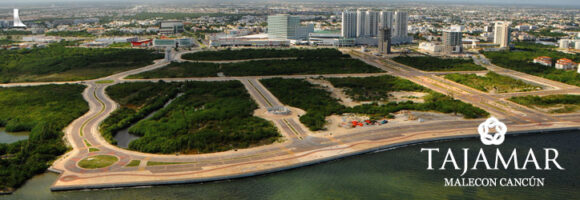
Environmentalists are denouncing the recent overnight destruction of mangroves in the Malecón Tajamar area of Cancún. Malecón Tajamar is a tourist complex with infrastructure financed by Mexico’s federal tourism development agency Fonatur, which has form when it comes to environmental destruction. (See, for example, Conflict at Cabo Pulmo: mass tourism meets ecotourism.)

Development or Environment?

Development or Environment?

Mexico is one of the world’s wealthiest countries in terms of mangroves, with between 600,000 and 900,000 hectares of them in total. (For details about why this range of values is so large, see How fast are mangroves disappearing in Mexico?) To prevent further destruction Mexico enacted federal legislation in 2007 designed to protect existing mangroves.

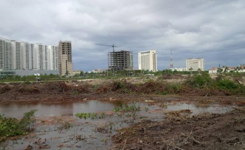
Credit: Adriana Varillas, El Universal

Credit: Adriana Varillas, El Universal

Despite this, news reports indicate that heavy equipment, protected by armed police, moved in to Malecón Tajamar on 16 January 2016 and proceeded to destroyed 57 hectares (140 acres) of mangroves overnight. This mangrove swamp had been under threat for some time, but the activist movement “Salvemos Manglar Tajamar” had gained considerable public support and managed to bring a temporary halt to further development work in the area.

Greenpeace México alleges that Fonatur falsified environmental assessments, and even denied that any mangroves existed at Malecón Tajamar. According to Greenpeace, municipal, state and federal authorities colluded to ensure that the mangroves would be destroyed and that construction of the tourist complex could continue.

Activists claim that the distinctive and ecologically-important mangrove habitat was home to crocodiles, iguanas, birds and snakes, and that the ecosystem services (fishing, coastal protection, habitat for other species, carbon sequestration, etc) provided by a healthy mangrove swamp outweighed all other options. (For more details, see How valuable are Mexico’s mangrove swamps?)

Greenpeace México not only condemned the destruction of mangroves but called for an immediate halt to work in the area pending a full and open discussion with all stakeholders. They believe that the mangroves could possibly reestablish themselves in time if the area is left untouched.

Work to infill the area cleared of mangroves has now been suspended while animal experts try to rescue, and relocate, as many of the animals who survived the initial disturbance as possible. In theory, Fonatur and the federal Environmental Secreatariat were obligated to ensure that developers had an adequate plan in place, prior to clearance, to relocate all animals, in line with the initial environmental impact report approved in 2005.

Another NGO, Defensores del Manglar, has announced it will submit a formal complaint about recent events at Malecón Tajamar to the headquarters of the Ramsar Convention in Switzerland. The Ramsar Convention, to which Mexico is a signatory, is an international accord for the conservation and sustainable use of wetlands. Defensores del Manglar claims that Malecón Tajamar is protected under the Convention, even though the area does not appear to be specifically included on this list of Mexico’s 140+ Ramsar sites.

Geo-Mexico joins with Greenpeace Mexico and Defensores del Manglar in deploring the destruction of Mexico’s remaining mangroves and will continue to publicize cases where developer greed results in irreversible environmental damage.

Related posts:

The El Triunfo Biosphere Reserve in Chiapas

 Other  Comments Off on The El Triunfo Biosphere Reserve in Chiapas
Jan 182016
 

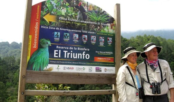
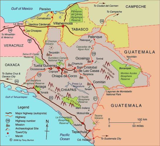
The El Triunfo Biosphere Reserve covers 119,177 hectares in the southern state of Chiapas, in the municipalities of Acacoyagua, Angel Albino Corzo, La Concordia, Mapastepec, Villa Corzo, Pijijiapan and Siltepec. The reserve ranges in elevation from 450 meters above sea level to 2550 meters (8370 ft).

El Triunfo is part of the mountain range known as Sierra Madre de Chiapas in the southern part of the state. It straddles the continental drainage divide. Short rivers on one side flow to the Pacific Ocean. The rivers on the other side of the divide are the start of one branch of the mighty Grijalva-Usumacinta River (Mexico’s largest river in terms of discharge) which flows into the Gulf of Mexico.

el-triunfo

The El Triunfo reserve was first established in 1990. In 1993, it was officially designated a World Biosphere Reserve by the MAB-UNESCO program.

El Triunfo has numerous plants and animals. Its vegetation, representative of several distinct ecosystems, includes evergreen tropical humid forest; mountain rainforest; tropical deciduous rainforest; pine-oak forest; and evergreen cloud forest. On Cerro Ovando alone, about 800 different species of plants have been recorded.

mapchiapas

Map of Chiapas. Click here for interactive map of Chiapas on Mexconnect.com; all rights reserved

Threatened mammalian species found in the reserve include Geoffroy’s spider monkey, margay, the tapir (Tapirus bairdii), jaguar (Panthera onca) and puma. Unfortunately, this means that this is a favored area for wildlife hunters, poachers and traffickers.

The bird fauna is especially distinctive. The reserve is one of the relatively few places in Mexico where ornithologists have the chance to find the horned guan (Oreophasis derbianus), resplendent quetzal (Pharomachrus mocinno), cabanis’ tanager (Tangara cabanisi), azure-ramped tanager and great curassau. The resplendent quetzal is considered one of the most beautiful birds in the Americas, and its feathers were highly prized in pre-Columbian times.

This BBC video is an outstanding visual introduction to the Reserve:

As is the case for other Biosphere Reserves, local people are allowed to live and work in the El Triunfo Reserve. The core area (25,719 hectares) is restricted to conservation and research only, but the buffer/transition areas (93,458 ha) are home to about 12,000 people. El Triunfo is also on the migration route of Guatemalan Indians entering Chiapas either to work (seasonally) on coffee plantations or as the first stage of their journey further north. This floating population is trickier to quantify.

The area was important historically for the production and trade of items such as cacao, quetzal feathers, jade and copal resin. In the 17th century, the population grew rapidly in this region with the establishment of plantations, and later cattle ranches. Coffee was introduced at the end of the 19th century and quickly became the dominant cash crop for most small landowners. Environmental damage, mainly from clearance and cattle ranching, became a major problem, but it was not until the 1970s and pioneering work of Dr. Miguel Alvarez del Toro that any restrictions were placed on land use.

Today, the main economic activities within the buffer areas of the reserve are agriculture (coffee, corn), the collection of Chamaedorea palms, trade, construction and cattle raising.

Several NGOs are working with farmers in the buffer zone to improve their livelihoods and ensure that farming can be carried out sustainably and still support the existing population. For a lively introduction to this topic, try (Co-operative) Value Added on the blog Small Farmers. Big Change. As they say, “a green and more just food system starts with small farmers”.

Related posts:

Latest additions to Mexico’s Protected Natural Areas

 Mexico's geography in the Press, Updates to Geo-Mexico  Comments Off on Latest additions to Mexico’s Protected Natural Areas
Jul 202015
 

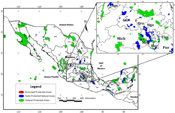
Alejandro del Mazo Maza, head of Mexico’s Commission for Protected Natural Areas (Áreas Naturales Protegidas), says that the formal decrees for seven additional PNAs (Protected Natural Areas) will be published shortly. In some cases, the decrees apply to areas whose status as protected areas was first announced months or even years ago.

The seven new additions are in the north and northwest regions of the country:

  • the Marismas Nacionales biosphere reserve in Sonora
  • Monte Mojino (protected area of flora and fauna), Sonora
  • the Sierra de Tamaulipas biosphere reserve
  • the Playa Boca de Apiza sanctuary in Colima
  • the Islas del Pacífico of Baja California reserve
  • the Semiarid Desert reserve of Zacatecas
  • the Sierras la Giganta y Guadalupe reserve in Baja California Sur

Mexico currently has 177 PNAs (in various categories), and the new additions bring that total to 184.

In addition, preparatory studies are underway to establish two additional biosphere reserves, for the Mexican Caribbean and the Gulf of California (Sea of Cortés).

Mexico's Protected Areas (Gallina, 2012)

Mexico’s Protected Areas (Gallina, 2012)

The Commission of PNAs is working hard to complete formal management plans for every PNA – environmental, social and economic issues. At present, only 97 of the 177 PNAs have such plans in place, with the latest plans published only weeks ago for:

For example, the management program for the whale shark reserve authorizes a maximum of 160 whale-watching boats in an effort to ensure sustainability.

Source of Map:

Sonia Gallina, 2012. “Is Sustainablity Possible in Protected Areas in Mexico? Deer as an Example of a Renewable Resource.” Sustainability 2012, 4 (10), 2366-2376

Related posts:

Jun 152015
 

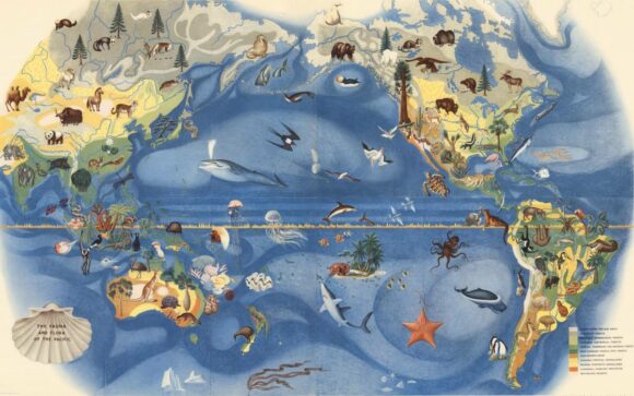
Visitors to the De Young Museum in San Francisco can admire a wonderful mural showing the fauna and flora of the Pacific, painted by Mexican artist José Miguel Covarrubias (1904-1957) for the city’s 1939-1940 Golden Gate International Exposition on Treasure Island in San Francisco Bay.

Covarrubias Mural of the Pacific

Covarrubias Mural of the Pacific (Click image to enlarge)

Following conservation work performed by experts in Mexico, the mural is currently on loan to the De Young Museum from its owners, San Francisco’s Treasure Island Development Authority.

While the De Young Museum website continues to describe this mural as “one of a six-part series of fanciful, larger-than-life-size maps created by noted Mexican artist Miguel Covarrubias”, we sincerely doubt that these murals were ever really “larger-than-life-size”!

The mural is one of the five remaining murals painted by José Miguel Covarrubias for the exposition. The whereabouts of a sixth mural, which completed the series known as “Pageant of the Pacific”, are unknown.

The details are exquisitely painted, and the mural is as beautiful as it is educational.

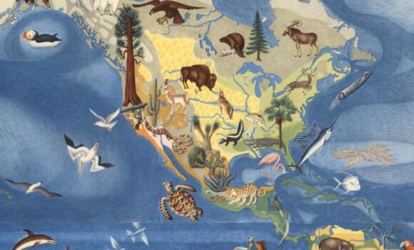
covarrubias-flora-fauna-north-america-sm

Covarrubias: Mural of the Pacific (detail)

As ever-erudite Jon Haeber writes in his blog post about this mural, painted “at a critical juncture in America’s history”, its artist “was a confidante of Mexican greats Diego Rivera and Frida Kahlo. As a caricaturist for Vanity Fair and The New Yorker, it could easily be assumed that Covarrubias is largely ignored by fine art historians, but he was an anthropologist and geographer as much as he was an artist, which gave him a unique respect among art aficionados… Not only are they an informative lesson in Geography, but they are also a great piece of history – to say nothing about their creator.” [http://www.terrastories.com/bearings/covarrubias-art-forms-pacific viewed June 2015]

Covarrubias was indeed a geographer and ethnologist. Among other works, he authored Island of Bali (1937); Mexico South (1946); The Eagle, the Jaguar, and the Serpent – Indian Art of the Americas; North America: Alaska, Canada, the United States (1954); and Indian Art of Mexico and Central America (1957).

The temporary structures on Treasure Island were subsequently demolished and Covarrubias’ six murals sent to the American Museum of Natural History in New York. When they were brought back to California in the late 1950s, the series was missing the mural entitled “Art Forms of the Pacific Area”. The titles of the five surviving murals are The Fauna and Flora of the Pacific, Peoples, Economy, Native Dwellings, and Native Means of Transportation.

Mexican-themed garden wins gold at UK’s Chelsea flower show

 Mexico's geography in the Press  Comments Off on Mexican-themed garden wins gold at UK’s Chelsea flower show
Jun 012015
 

The U.K. has declared 2015 as the “Year of Mexico” and is hosting numerous cultural and trade events this year related to Mexico. Not to be outdone, a Mexican-themed Pavilion exhibit has won gold at the prestigious Chelsea Flower Show, held in London in May. The show is organized each year by the Royal Horticulture Society and was first held more than a century ago.

The gold-medal winning garden design in 2015 was based on a very unusual garden created in Mexico by the eccentric Englishman Edward James at “Las Pozas” (the Pools), the home he built near Xilitla in the state of San Luis Potosí. James (1907-1984) was a sponsor of the surrealist art movement, as well as a surrealist artist in his own right. His entire estate in Mexico became his canvass for a marvelously-creative collection of sculptures and follies set in luxuriant, semi-tropical jungle.

The winning garden at Chelsea, entitled “Surreal Pillars of Mexico,” was designed by Jon Wheatley and sponsored by HSBC and the U.K.’s National Dahlia Collection. The dahlia is Mexico’s national flower:

Chelsea Garden Show

Surreal Pillars of Mexico (partial view)

“Surreal Pillars of Mexico” had a circular structure and pillars that emulated Edward James’s garden in Mexico. It included 50 different types of dahlias, surrounded by over 100 plants and vegetables such as lettuce, cactus and the exotic agave plant.

New varieties of dahlias, first described in Mexico in 1529, had been developed via selective breeding and propagation programs even in pre-Columbian botanical gardens. The dahlia arrived in the U.K. in the early nineteenth century, via Spain and only after several unsuccessful attempts at introducing it. The National Dahlia Collection in the U.K. cultivates and promotes the flower; all the varieties existing in the U.K. originated from just three types of dahlias.

The Year of Mexico to the United Kingdom includes more than 100 separate exhibitions, concerts, festivals, academic workshops and artistic residencies; as well as trade missions, research projects, grants and scholarships. These shows will highlight the creativity of Mexican writers and artists, while also showcasing the country’s history and its modern-day industrial strength.Events are being held at a number of cities, including London, Cardiff, Edinburgh, Belfast, Manchester, Oxford, Liverpool and Birmingham.

Related posts:

A little bit of Mexico in Indonesia (Mexican botanic garden in Indonesia)

 Other  Comments Off on A little bit of Mexico in Indonesia (Mexican botanic garden in Indonesia)
Apr 302015
 

Like many geographers, I have long held a more than passing interest in botanical gardens. From a geographic standpoint, botanical gardens offer the chance to closely examine plants that can be very difficult, virtually impossible, to find in the wild. Many botanical gardens display the typical plant assemblages that are common in the local region, while also giving a plant-based snapshot of different environments elsewhere.

Mexico has an extraordinary variety of flowering plants, estimated (even twenty years ago) to include more than 20,000 different species.  Many garden plants commonly planted in Europe, the USA and elsewhere originated in Mexico.

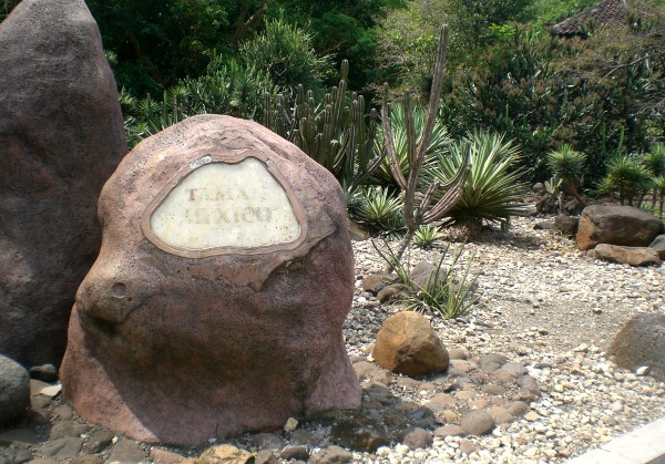
Over the years I’ve looked at Mexican cacti and succulents in numerous botanical gardens around the world, but was pleasantly surprised when visiting Indonesia in 2013 to discover that the Purwodadi Botanic Garden in Pasuruan, East Java, actually has an entire section devoted to the Mexican flora characteristic of semi-arid conditions (see photos).

Entrance to the”Taman Mexico” (Mexico Park):

indonesia-0

The 85-hectare Botanic Garden was first established in 1941, and has plants collected from a wide range of areas in Indonesia, as well as smaller sections devoted to plants from elsewhere. I’m not sure how old the Mexican section is, but the plants are clearly thriving, despite showing some signs of neglect. This is mainly because the climate in the Botanic Garden (located at 8 degrees south of the equator and longitude 113 degrees east) is fairly similar to some parts of Mexico. The Garden has an elevation of 300 meters and an annual rainfall of 2366 mm.

indonesia-3

indonesia-4

indonesia-2

indonesia-5

indonesia-6

Assuming that the Mexican Embassy in Jakarta had some part in establishing this fine display of Mexican flora, perhaps it is time that embassy officials revisit their gift and see whether they can’t enhance the Mexican garden by sponsoring some information signs, so that visitors can truly appreciate these venerable plants, not only for their beauty, but also for their ecological and economic significance.

indonesia-1

There are lots of additional botanical goodies to be seen here in addition to the Mexican Park, including stately jacaranda trees and an amazing collection of banana plants. The Purwodadi Botanic Gardens are well worth a visit if you ever happen to be anywhere in the vicinity. They are located about 70 kilometers south of the city of Surabaya towards Malang. Allow at least 90 minutes for the drive.

Photos by Tony Burton; all rights reserved.

Details:

Purwodadi Botanic Garden, Jl. Surabaya-Malang Km.65 Purwodadi Pasuruan, Pasuruan, East Java 67163, Indonesia. Tel: +62341426046 www.krpurwodadi.lipi.go.id email: redaksiwebkrp@gmail.com

Embassy of Mexico in Jakarta: embmexic@rad.net.id / embmexico@gmail.com

Oct 062014
 

According to press reports such as Buscan dar “nueva cara” a Puerto Arista (in El Economista), there are plans afoot to develop nearby mangrove swamps as part of an ecotourism project. Local architects in the coastal town of Puerto Arista in Chiapas are backing the project to build what might best be called Mangrove Riviera.

The state government has released this 4-min video that summarizes the plan, with models and images of the area:

The initial investment required to get Riviera Manglar “Pakal Ahau” under way is around $120 million. The major advantage, from the state’s point of view, is that it would open up a new region of the state for tourism, cashing in on the area’s natural wealth, especially its mangroves. Proponents argue that the town could easily become a major center for ecotourism and that provided that the project incorporates a high degree of sustainability, and prioritizes the cultural identity of each location, it could be a model for similar projects elsewhere.

The six main places involved in Riviera Manglar “Pakal Ahau” are

  • Puerto Chiapas
  • Zacapulco
  • La Encrucijada
  • Costa Azul
  • Chocahuital
  • El Gancho

The project would extend to a subregion including Bahía Paredón, Boca del Cielo, Playa del Sol, Bahía Marías, El Madresal, Mojarras, Laguna La Joya, Cabeza de Toro, Cerro Bernal, Manglares and Villa Tortuguero.

In time, Puerto Arista could become another “tourist gem” in Chiapas and offer an interesting continuation of the long-standing Ruta Maya.

Related posts:

How fast are mangroves disappearing in Mexico?

 Updates to Geo-Mexico  Comments Off on How fast are mangroves disappearing in Mexico?
Sep 012014
 

It is surprisingly difficult to give a single, definitive response to this seemingly simple question, so in 2008, Arturo Ruiz-Luna and a group of researchers set out to answer the question once and for all, by taking a close look at the available data and its reliability.

The first challenge is to define precisely what counts as “an area of mangroves”. Since the edges of any one type of vegetation tend to merge gradually into the next, the boundaries between types are often not clear or discrete. The second challenge is to find comparable maps or records of the extent of mangroves in former times. In many cases, earlier maps were based on simple aerial photography as opposed to the more sophisticated satellite imagery available today. Equally, studies relying on different technology may produce quite different results.

Ruiz-Luna and his colleagues concluded that there was a high degree of uncertainty over the true extent of mangrove cover in Mexico and over the rates of mangrove depletion.  The unreliability stemmed from the very different estimates of mangrove cover given in earlier studies.

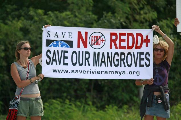
Opposition to mangrove destructon

Opposition to the destruction of mangroves, Cancún climate summit, 2010

They found that the earliest estimate of the extent of mangroves in Mexico, made in 1973, was 700,000 ha (1.7 million acres). From 1980-1991, a figure of 660,000 ha was widely quoted. This is thought to have been derived from the previous figure using a linear regression to include estimated deforestation rates.

On the other hand, a study in 1992, based on 1:3,800,000 scale maps, arrived at an areal extent of 932,800 ha. A 1993 government estimate, based on satellite imagery and supporting ground survey, came up with a figure of 721,554 ha. A 1994 estimate, also using satellite data, arrived at a similar figure.

Since 2000, estimates vary from a low of 440,000 ha (based on deforestation rates and linear regression) to a high of 955,866 (almost all of it mangrove, with a small area of secondary mangrove succession).

According to Ruiz-Luna and his co-authors, it is therefore likely that the true value of the extent of mangroves lies somewhere between 600,000 and 900,000 ha, with the authors plumping for 800,000 ha as a reasonable estimate.

Why are mangroves lost?

Mangrove habitats are lost due to damage (deforestation) from logging and land use changes. Examples of land use changes adversely affecting the extent of mangroves are:

  • the conversion of mangroves to harbors, as in Manzanillo (Colima)
  • mangroves being converted for hotels and tourist use (Cancún)
  • mangrove swamps being reassigned for aquaculture (San Blas)

The loss of mangroves can also result from changes to hydrological systems on the landward side of the mangroves. For example, when an artificial channel was opened in the 1970s in Cuautla (Nayarit) to connect the Marismas Nacionales with the sea, the channel was originally about 50m wide. It is now about 600m wide in the middle, and more than 1000m wide at its mouth, due to damage caused by the river flow, and from the greater exposure of mangroves to higher salinity water, as well as increased mangrove mortality from storms and hurricanes.

While there are some small-scale projects to replant mangroves in some tourist area, this is unlikely to be a good substitute for the original mature mangrove ecosystem. This is why Geo-Mexico is happy to help publicize public protests against mangrove destruction, such as the one pictured above which took place at the Cancún climate summit in 2010.

Reference:

Arturo Ruiz-Luna, Joanna Acosta-Velázquez, César A. Berlanga-Robles. 2008. “On the reliability of the data of the extent of mangroves: A case study in Mexico.” Ocean and Coastal Management 51 (2008) 342-351.

Related posts:


Where are Mexico’s mangrove swamps?

 Updates to Geo-Mexico  Comments Off on Where are Mexico’s mangrove swamps?
Aug 142014
 

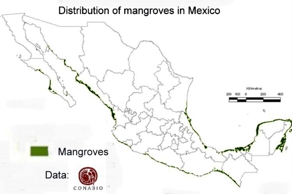
The National Commission for the Knowledge and Use of Biodiversity (Comisión Nacional para el Conocimiento y Uso de la Biodiversidad, CONABIO), has identified 81 distinct areas in Mexico that have mangroves with “biological significance and in need of varying degrees of ecological rehabilitation” (see summary map). These regions are distributed as follows:

  • 10 on the northern Pacific Coast
  • 6 on the central Pacific Coast
  • 13 on the southern Pacific Coast
  • 27 on the Gulf of Mexico and
  • 25 on the Yucatán Peninsula.

A national inventory has now been compiled by CONABIO. All areas have been surveyed and preliminary descriptions published including details of their location, size, physical characteristics, socioeconomic conditions, local uses of mangrove, biological details, including vegetation structure, and an assessment of local impacts and risks, management and existing conservation measures.

Map of distribution of mangroves in MexicoThe areas of mangroves have been mapped at a scale of 1:50,000 and satellite photos from 2005-2006 have been used in conjunction with fieldwork to calculate the areas of mangroves. The final map is believed to be more than 90% accurate, a reasonable baseline for future comparisons. CONABIO is planning to resurvey the mangrove areas every 5 years following the same methodology.

According to preliminary comparisons with previous attempts to quantify the extent of mangroves in Mexico (the subject of a future post), the loss of mangroves was greatest in the period 1970-1980, and in 2000-2005, but then diminished in the period 2005-2010.

Between 2005 and 2010, the states where mangrove loss remained high (as a percentage of the total area of mangroves in the state) included Chiapas, Baja Californa Sur and Sonora. However, the states losing the largest areas of mangroves in absolute terms were Quintana Roo, Campeche and Nayarit. Jalisco has the unfortunate distinction of being the state where coastal mangrove loss was highest (in terms of the proportion of its total coastline length bordered by mangroves).

Related posts:

How similar are Mexico’s two major deserts, the Sonoran Desert and the Chihuahuan Desert?

 Other  Comments Off on How similar are Mexico’s two major deserts, the Sonoran Desert and the Chihuahuan Desert?
May 292014
 

There are four desert areas in North America. Two of these areas (Great Basin and Mojave) are in the USA. The other two (the Sonoran Desert and the Chihuahuan Desert) are almost entirely in Mexico, but extend northwards across the border. The Sonoran Desert includes most of the Baja California Peninsula, together with the western part of the state of Sonora. The Chihuahuan desert is the northern section of the Central Plateau, including the northern parts of the states of Chihuahua.

The Chihuahuan Desert has been intensively studied by scientists interested in the possibility of life on Mars – see this New York Times article: Learning About Life on Mars, via a Detour to Mexico.

In a previous post – Why is northern Mexico a desert region? , we saw how the combination of the descending air of the Hadley Cell, which results in surface high pressure, and the effects of rain shadows resulting from neighboring mountain ranges contribute to the low annual rainfall total characteristic of both Mexico’s desert areas.
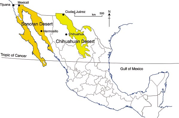
deserts-colorWhile these two deserts both experience an arid climate, they also have many differences.

Area

The Sonoran Desert has an area of about 311,000 square kilometers (120,000 sq mi). The Chihuahuan Desert has an area of about 362,000 square kilometers (139,769 sq mi).

Elevation

The Sonoran Desert is lower in elevation that the Chihuahuan Desert, with some parts (in the USA) lying below sea level. The Chihuahuan Desert varies in elevation from 600–1675 m (1969–5495 ft).

Summer temperatures

The Sonoran Desert tends to have higher summer temperatures than the Chihuahuan Desert, though even in the Chihuahuan Desert, daytime temperatures in summer are usually between 35 and 40̊C (95-104̊F).

Seasonal rainfall patterns

The ratio of winter to summer rainfall decreases from west to east. Most of the Sonoran Desert (to the west) has a bimodal rainfall regime with spring and summer peaks. On the other hand, most of the limited rain that falls in the Chihuahuan Desert comes in late summer.

The Chihuahuan Desert has a mean annual precipitation of 235 mm (9.3 in), though annual totals vary from 150 to 400 mm (6–16 in).

Vegetation, fauna and biodiversity

These seasonal rainfall differences result in significant differences in the vegetation of the two areas.

The bimodal precipitation in the Sonoran Desert provides two flowering seasons each year. Some plants bloom in spring, following winter rains, while others flower in late summer, following summer rains. Typical plants in the Sonoran Desert include columnar cacti (Cereus spp.) such as sahuaro, organ pipe, and cardon, as well as many other types of cacti, including barrels (Echinocereus), chollas (Opuntia spp.) and prickly pear (Opuntia spp.). Other succulent plants are also common.

More than 60 mammal species, 350 bird species, 20 amphibian species, 100 reptile species, 30 native fish species, 1000 native bee species, and 2000 native plant species have been recorded in the Sonoran Desert. The Sonoran Desert includes the Colorado River Delta, which was once an ecological hotspot within the desert, fueled by the fresh water brought by the river, though this flow has become negligible in recent years. See, for example, Will the mighty Colorado River ever reach its delta?

The vegetation of the Chihuahuan Desert is dominated by grasslands and shrubs, both evergreen and deciduous. Common species include tarbush (Flourensia ternua), whitethorn acacia (Acacia constrictor) and creosote bush (Larrea tridentata). The Chihuahuan desert has small cacti; succulent agaves (Agave spp.) and yuccas. Plants bloom in late summer, following the summer rains.

The Chihuahuan Desert is home to about 350 of the world’s 1500 known species of cactus, and includes the fascinating area of Cuatro Ciénegas, which has an unusually high number of endemic plant species and is one of the world’s richest hotspots for locally endemic cacti.

The Chihuahuan Desert is considered to be one of the three most biologically rich and diverse desert ecoregions in the world, rivaled only by the Great Sandy Tanmi Desert of Australia and the Namib-Karoo of southern Africa. However, settlements and grazing have heavily degraded the natural vegetation of some parts of the Chihuahuan Desert.

he Chihuahuan Desert has about 3500 plant species, including up to 1000 species (29%) that are endemic. The high rate of endemism (true for cacti, butterflies, spiders, scorpions, ants, lizards and snakes) is due to a combination of the isolating effects of the basin and range topography, climate changes over the past 10,000 years, and the colonization of seemingly inhospitable habitats by adaptive species. See here for more details of the flora and fauna of the Chihuahua Desert.

Landforms

This basin and range landscape of the Sonoran Desert trends north-northwest to south-south-east. Parallel faulted blocks are separated by alluvial bajadas (broad, debris-covered slopes), pediments and plains, which become wider approaching the coast. Despite being a desert area, this region exhibits many features that have resulted from water action, including wadis, salt flats, stream terraces and alluvial fans.

For a fuller description of the landforms of the Sonoran Desert, see this extract from A Natural History of the Sonoran Desert (edited by Steven J. Phillips and Patricia Wentworth Comus) published by the Arizona-Sonora Desert Museum.

The Sonoran Desert includes the subregion of the Sierra of Pinacate (part of El Pinacate and Gran Desierto de Altar Biosphere Reserve) with its distinctive volcanic cones, craters and lava flows. For more details, see The landforms of the El Pinacate and Gran Desierto de Altar Biosphere Reserve.

The landforms of the Chihuahuan Desert have been molded by tectonic uplift and erosion. Steep-sided but low hills are separated by wide bajadas from former lake beds and alluvial plains, occupying inland basins known as bolsons. Many parts form closed, interior basins with no external drainage. South of Ciudad Juárez, at Samalayuca, is one of Mexico’s most extensive areas of sand dunes. This is one of the most arid parts of the country, with high levels of salinization.

Related posts:
Cosmic botanical garden in Toluca

 Other  Comments Off on Cosmic botanical garden in Toluca
Mar 152014
 

The city of Toluca (population 1.8 million), the capital of the State of México, was in the news recently as the site for the tri-national meeting between the heads of state of Mexico, the USA and Canada to mark the 20th anniversary of NAFTA.

Nestled away inside the city, away from its burgeoning factories, is the former city market. The market closed in 1975. Plans to demolish it were forestalled when renowned Mexican artist Leopoldo Flores stepped up with a plan to restore the market building, which dated back to 1909, into an artistic gem housing a botanical garden.

Cosmovitral, Toluca

Used under Creative Commons Attribution-Share Alike attribution

The market’s original windows were replaced with large glass murals, comprised of half a million pieces of glass and covering a total area of more than 3,000 square meters. The revamped building, now known as the Cosmovitral, was reopened in 1980. In 2007, the Cosmovitral narrowly missed being named one of the 13 man-made wonders of Mexico.

The centerpiece of the Cosmovitral murals is the stunning image entitled Sun Man (Hombre Sol).

Possibly the world’s best decorated glasshouse, the Cosmovitral houses over 500 different plants from around the world and has become one of the city’s single most popular tourist attractions, though rarely visited by foreign tourists.

Where? The Cosmovitral is located in downtown Toluca at the intersection of Juárez and Lerdo de Tejada streets. Guided tours are available.

When? It is normally open Tuesday to Saturday, 10 a.m. to 6 p.m.; Sundays 10 a.m. to 3 p.m.

Admission? Tickets are 10 pesos (less than a dollar) for adults, 5 pesos for children. Guided tours, mostly to explain the Cosmovitral’s stained glass, are available. Art exhibitions are hosted regularly.

Related posts:

May is a critical month in the 2012 wildfire season in Mexico

 Mexico's geography in the Press  Comments Off on May is a critical month in the 2012 wildfire season in Mexico
May 032012
 

This month is likely to be a critical month for wildfires. As we reported in an  earlier post – The geography of wildfires in Mexico: the disastrous wildfire season of 2011 – 2011 was Mexico’s worst year for wildfires for 30 years. The on-going drought in northern Mexico (the worst for 70 years) means that this year’s wildfire season is not likely to be any better.

May is the critical month because it marks the end of the dry season in most of Mexico, the time when the natural landscape looks parched. During the month of May, the landscape waits for the start of the rainy season, a season that is sometimes preceded by a spate of electrical storms. Electrical storms can trigger wildfires if they ignite the tinder-dry vegetation.

In the first four months of 2012, there have been some significant wildfires in several parts of Mexico, including one uncomfortably close to the Guadalajara Metropolitan Area, which has a population of almost 5 million.

Here is a brief round-up of the major wildfires in 2012 so far:

Durango

The largest single fire in the country so far in 2012 was in Potrerillos, in the municipality of Canatlán. It damaged 112 square kilometers (43 square miles). The 56 other wildfires experienced by Durango so far this year have all been small. The total area of the state damaged by wildfires this year currently stands at about 120 square miles.

Coahuila
Coahuila has experienced 30 fires so far this year, causing to more than 160 square kilometers. The latest three fires have been brought under control in the past few days. In the Sierra Salsipuedes (municipality of San Buenaventura) a wildfire destroyed 8 square kilometers of brush. Wildfires in the Sierra de la Madera (in the municipalities of Ocampo and Cuatrociénegas) damaged 37 square kilometers and 17 square kilometers respectively.

Sonora

So far in 2012, firefighters have fought 19 wildfires, affecting almost 40 square kilometers it total, mainly grassland and scrub, in the municipalities
of Yécora, Álamos, Rosario Tesopaco, Bacoachi, Quiriego, Nacori Chico and Cucurpe.

Jalisco

Some 1,000 firefighters battled for almost a week to bring a major wildfire in the Primavera Forest (Bosque de la Primavera) under control. The Primavera Forest is a partially-forested wilderness area with hot springs. It is set in a volcanic caldera on the western outskirts of Guadalajara, Mexico’s second largest city.

Location of Primavera Forest in relation to Guadalajara and Lake Chapala.

Location of Primavera Forest in relation to Guadalajara. Credit: Tony Burton; all rights reserved.

Initial reports say that the blaze began on 14 April when a garbage fire got out of control. By the time it was brought under control, the fire had damaged 85 square kilometers, about 35% of it forested, making it the worst fire in the area since 2005. That area damaged is about one-third of the total area of the Primavera Forest. Residents of Guadalajara were luckier than in 2005 because winds this time blew most of the smoke away from the city, so the city’s air quality was not seriously compromised. Even so, schools in some areas were closed briefly as a precaution.

The Primavera has a chequered history of protection. Most of the land is privately owned. It was declared a federally protected area in 1980, but ever since then real estate developers have nibbled away at the edges of the protected area, largely ignoring attempts by local officials to enforce zoning regulations.

Morelos
Several relatively small fires have damaged parts of this small state. The three most significant wildfires to date were in the municipalities of Tepoztlán, Tlalnepantla and Tlayacapan. They damaged 5 square kilometers of forest, but, because of the precipitous terrain, required the combined efforts over four days of more than 700 firefighters. The area, very close to Mexico City, is a popular weekend destination for city dwellers, and renowned for its ecotourism potential. Tepoztlán is one of Mexico’s Magic Towns.

Puebla
A small fire in Cerro del Palmar (in Liebres municipality) unfortunately resulted in two deaths, including that of a firefighter.

Oaxaca
More than 30 square kilometers have been damaged by wildfire this year in various parts of the state.

Related posts:


Why is biomass density in Mexico relevant to climate change?

 Maps, Other  Comments Off on Why is biomass density in Mexico relevant to climate change?
Apr 282012
 

How can we measure the health of forests and other forms of natural vegetation? It has become commonplace to read about biodiversity and many conservation programs rightly stress its importance in the global scheme of things. In a previous post, we examined the biodiversity of Mexico and saw how it is one of the most biodiverse countries in the world.

Biodiversity may be a useful indicator of likely ecological resilience in the face of changing circumstances such as global climate change, but it does not tell the whole picture. In simple biodiversity measures, each species is counted and treated as being equally important. Species close to extinction are singled out for conservation efforts in an attempt to preserve a viable wild population of that species. If all else fails, specimens are transferred to botanical gardens or seeds are collected and stored in the hope that the species can be reintroduced and reestablished in a suitable location at some point in the future.

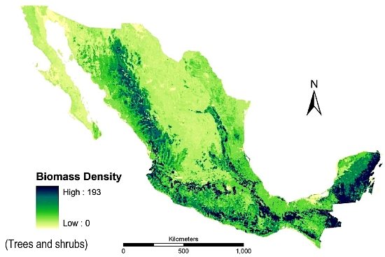
Biomass production in Mexico (Trees and bushes)

Biomass density in Mexico (trees and shrubs); from deJong et al, 2006.

But are all plant species equal? Should a giant redwood count the same as a dandelion? Certainly in terms of their ability to store carbon, larger plants are more valuable than smaller plants, though the total number of each species also matters. Storing carbon is important. When trees are cut down and burned (to clear the way for agriculture or settlement, for example) this stored carbon is released into the air and contributes to the processes causing global warming.

The term biomass is used to describe the total mass of living organic matter in a plant or in an area. The total biomass of a plant includes its bark, leaves and twigs. In a tropical forest, biomass includes every tree, shrub, sapling, vine, epiphyte and flower. About 50% of the biomass in most forests is carbon. The amount of biomass varies seasonally and is not necessarily stable over time, since plants increase their biomass as they grow. In a forest, the balance that matters in terms of sustainable forestry is the balance between the forest’s production of “new” biomass (through photosynthesis) and the consumption of some of its biomass by chopping, burning and natural decay. Clearly, human activity can directly impact this balance, but so too can natural events such as forest fires.

Bio-geographers have a great interest in assessing biomass since it provides a starting point for numerous models that attempt to estimate the effects of releasing some, or all, of this stored carbon on future global climates. Increasingly, their estimates from the use of remote sensing and satellite images are proving to be quite reliable when tested by comparing them to the biomass of the same area calculated from on-the-ground fieldwork.

The measure of biomass shown on the map is biomass density. Biomass density is the total amount of above ground living organic matter expressed as oven-dry metric tons per hectare. This map immediately reveals why conserving Mexico’s southern rainforests is so important. They are not only the most biodiverse areas of Mexico, their high biomass density values show that they also have far more than their fair share of Mexico’s total biomass. Conserving and managing these forests therefore needs to be a priority strategy in Mexico’s efforts to limit and mitigate climate change.

Sources:

The map comes from “Advances of Mexico in preparing for REDD” by Bernardus H.J. de Jong, Leonel Iglesias Gutiérrez and José Armando Alanís de la Rosa. Presentation given at the UNFCCC Workshop on Methodological Issues relating to Reducing Emissions from Deforestation and Forest Degradation in Developing Countries. Tokyo, Japan, 25 to 27 June 2008.

To read more about estimating biomass, see Estimating Biomass and Biomass Change of Tropical Forests: a Primer. (FAO Forestry Paper – 134) by Sandra Brown. FAO Forestry Paper 134. 1997.

Related posts:
The geography of wildfires in Mexico: the disastrous wildfire season of 2011

 Other  Comments Off on The geography of wildfires in Mexico: the disastrous wildfire season of 2011
Jan 212012
 

In the past 20 years, wildfires have destroyed 47,000 square kilometers (18,000 sq. mi) in Mexico, equivalent to five times the area of all sections of Mexico City’s Chapultepec Park, the largest urban park in Latin America. The average fire in Mexico affects 32 hectares (80 acres); this figure has not changed significantly in recent years, even though the incidence of fires has increased somewhat due to a combination of climate change and an increase in the number of people living on the margins of forested areas. The National Forestry Commission (Conafor) says that 99% of Mexico’s forest fires are caused by human error, and only 1% are due to natural causes such as lightning strikes.

It generally takes about 30 years to rehabilitate forest areas ravaged by fire, with reforestation costing up to $2400/ha.

Wildfires are not entirely bad. For example, they help regenerate grassland areas, especially, with fresh young plants. On the other hand, in addition to protecting the existing vegetation, stopping wildfires when they occur helps to preserve soil structure and prevents additional emissions of CO2 from the burning of more plant material. At a national level, it is estimated that fires result in the erosion of 86 million metric tons of soil a year.

In a 2009 study, Conafor used 17 variables to identify the areas of the county with the highest risk of wildfires. Three broad areas accounted for the 900,000 square kilometers identified as having either a “medium” or “high risk” for wildfires:

  • i. Yucatán Peninsula, Chiapas, Oaxaca and Guerrero
  • ii. Central Mexico – Veracruz, Tlaxcala, Puebla, México, Michoacán, Jalisco and the Federal District. This area has more fires than any other because local populations often use fire to clear fields before planting.
  • iii. Baja California. This is the only area where the main fire season is in summer, from March to November. This is the rainy season in the remainder of Mexico, where the fire season corresponds with the winter dry season.

The first half of 2011 was an especially bad period for wildfires in Mexico, the worst for at least 30 years.

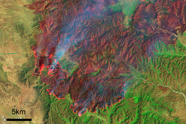
Coahuila wildfire, April 9, 2011 (Earth Observatory, Landsat-5)

Coahuila wildfire, April 9, 2011 (Earth Observatory, Landsat-5)

During the first half of 2011, serious wildfires devastated several areas of northern Mexico, with the states of Coahuila and Nuevo León being hardest hit. Other states badly affected included Durango, Chihuahua, Quintana Roo, Oaxaca, Puebla and Guerrero. More than 7,800 fires occurred, severely damaging a total area of 4100 square kilometers. 30 of Mexico’s 32 states were affected; only Tabasco and Baja California Sur escaped unscathed.

Conafor’s annual fire-fighting budget for the entire country is only 650 million pesos ($50 million dollars); the average annual area damaged by wildfires is only 2600 square kilometers, of which 500 square kilometers are forest. At the height of the 2011 fire season, more than 60 new fires were being reported each day, according to Conafor.

Coahuila

In the state of Coahuila, fires damaged 250 square kilometers in four weeks. It is believed that 50% of these fires were due to farmers losing control of deliberate burns. Farmers are supposed to have an adequate fire-suppression plan in place before setting a deliberate burn, but in practice this requirement is not enforced.

The main locations were La Sabina and El Bonito. Authorities were very slow to respond. Diana Doan-Crider, a wildlife biologist at Texas A&M University, has spent the past 25 years studying the Mexican black bear in the Serranía del Burro in Coahuila, an ecological corridor that runs parallel to the Eastern Sierra Madre. The area includes a large population of Mexican black bears. Doan-Crider claims that authorities completely ignored the first warnings and that their eventual response (two weeks after the first fires started) lacked adequate coordination. Many mother bears and their young cubs perished in the fires.

Firefighters in Coahuila had to cope with a spectacular but terrifying fire whorl or fire tornado

Nuevo León

In the neighboring state of Nuevo León, large swathes of ranching land were ravaged by fire. One rancher who lost more than 10,000 ha of cattleland was equally critical of the slow response time of firefighters who took more than two weeks to appear on the scene, by which time the fires had taken hold.

David Garza Lagüera had converted his 14,000 ha ranch into the Cumbres de Monterrey National Park, one of the key areas of bear habitat. The largest pines on his land were more than 150 years old. All were totally destroyed.

The worst damage was in Galeana, Montemorelos, Zaragoza, Aramberri and Mina. The area burned in Nuevo León in May 2011 was almost ten times the total area affected in the state for the whole of 2010.

Why was the 2011 fire season so bad?

To quote the Earth Observatory, “Lack of winter rain and frost left the plants dry and prone to fire. On top of that, the area has not burned for more than 20 years, during which time fuel built up. Thunderstorms and steady strong winds with gusts up to 110 km/h (70 mph) completed the formula for a dangerous, fast-moving wildfire.”

Ironically, the passage of Hurricane Alex in July 2010, which brought 1500 mm (60″) of rain to the Serranía del Burro, actually worsened the fire damage the following year. The rain from Hurricane Alex encouraged so much new growth in the final months of the rainy season that when it died back in the dry season, there was far more fuel available than usual for any wildfire that was sparked.

By the time the federal government declared a state of emergency, it was too late; the fires had already destroyed large areas of grassland, scrubland and forest. The emergency response when it finally arrived included help from the USA and Canada such as the specialist aerial Mars water-bombers stationed on Vancouver Island. The fires were only fully extinguished once the annual rainy season arrived.

As we now know, the disastrous fires of April-May 2011 were an early sign of Mexico’s worst drought for 70 years:

Aviation history as Mexico’s Aeroméxico uses biofuel for transatlantic passenger flight

 Mexico's geography in the Press  Comments Off on Aviation history as Mexico’s Aeroméxico uses biofuel for transatlantic passenger flight
Aug 132011
 

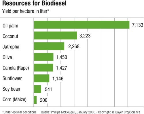
Aeroméxico, Mexico’s major international airline, made aviation history in July. Aeroméxico flight AM1, from Mexico City to Madrid, was the first ever commercial transatlantic passenger flight using bio-fuel. The Boeing 777 flew on a mixture of biofuel and regular jet fuel. Earlier this year, another Mexican airline, Interjet, began using renewable jatropha-based biofuel for flights between Mexico City and Tuxtla Gutierrez in the southern state of Chiapas. Jatropha is a genus of plants, mainly shrubs, that grow wild in several parts of Mexico, including Chiapas. Plantations of jatropha require four or five years of cultivation before the plant is sufficiently mature for commercial harvesting.

Jatropha-based biofuel is marketed as “green jet fuel” and is currently significantly more expensive than regular jet fuel. However, the price of biofuel is expected to fall rapidly as more of it is produced. The “life-time” emissions from using jatropha (including its growing period, processing and combustion) are estimated to be at least 60% less than using conventional jet fuel.

Sources of biodiesel.

Sources of biodiesel. Credit: Bayer CropScience

Mexico’s aviation sector will need 40 million liters of biofuel a year by 2015 in order to meet the national target of 1% of all airline fuel coming from renewable sources. The aviation industry’s long-term target is to halve its 2005 carbon footprint by 2050.

Despite Mexico’s recent adoption of jatropha-based biofuel, there is considerable controversy about the plant’s real value as a sustainable source of renewable energy. See, for example, the critique “Hailed as a miracle biofuel, jatropha falls short of hype” on Yale Environment 360, a publication of the Yale School of Forestry & Environmental Studies.

Mexico has forty UNESCO-designated biosphere reserves

 Other  Comments Off on Mexico has forty UNESCO-designated biosphere reserves
Jul 232011
 

A surprising percentage of Mexico’s land area is protected in one form or another. A very large number of sites of archaeological or historical importance are managed by the National Institute of Anthropology and History, more commonly known by its acronym INAH. In theory, all buildings more than 100 years old have some degree of protection (under INAH), but in practice this protection is often ignored by developers with other ideas.

Sites considered significant for their natural beauty are protected in a variety of ways, ranging from nature sanctuaries of local importance to protected areas, national parks and internationally recognized biosphere reserves. In total, more than 11.5% of Mexico’s land area is now protected. This percentage has risen steadily for more than a century.

The designation of biosphere reserve can only be made by UNESCO (U.N. Educational, Scientific and Cultural Organization), in a manner somewhat similar to the designation that some major historical sites enjoy as World Heritage Sites. One of the benefits of attaining Biosphere Reserve status is that it allows access to more sources of funding for conservation programs.

Mexico currently has 40 biosphere reserves. Only the USA (48), the Russian Federation (41) and Spain (41) have more. Worldwide, there are now (July 2011) 580 biosphere reserves in 114 countries. The guiding principle of biosphere reserves is that the local populace is not displaced, but actively involved in all aspects of management, research and monitoring.

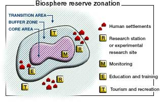
Biosphere Reserve Zonation

Biosphere reserves have a research-intensive core area or areas at their heart, surrounded by a buffer zone, where sustainable development is fostered, before gradually transitioning into the surrounding region. Many reserves have innovative systems of governance designed to ensure that the views of local people are fully respected. The idea of biosphere reserves was first proposed in 1968 at the UNESCO “Biosphere Conference”, the first international attempt to reconcile the need for conservation with the use of natural resources for development.

No system is perfect. The challenges for biosphere reserves include strengthening the worldwide network by establishing new reserves in areas where few currently exist, as well as helping meet the on-going funding needs for all the reserves. One of the most significant future threats to biosphere reserves is likely to be the habitat changes wrought by global warming.

One of the more startling surprises in the existing network of reserves is the almost total lack of protection afforded to such an amazing part of Mexico as the Copper Canyon region, with its indigenous Tarahumara people and world-class scenery. But perhaps one day this region, too, will become part of Mexico’s extensive system of protected areas.

Mexico’s Biosphere Reserves, as of July 2011:

Baja California Peninsula:

  • El Vizcaíno (Baja California Sur): desert, mountain and coastal/marine ecosystems, petroglyphs, wall paintings, birds and Grey whales.
  • Sierra La Laguna (Baja California Sur): contrasting ecosystems, woodlands and scrub, with high degree of endemism.
  • Alto Golfo de California (Baja California and Sonora): extraordinary geological formations with volcanic craters, dunes, oasis and beaches, and a diversity of plant associations.
  • Islas del Golfo de California (Baja California Sur and Sonora): series of over 240 islands with high number of endemic species; ornithological paradise.

Northern Mexico:

  • Mapimí (Durango, Chihuahua and Coahuila): fragile warm desert and semi-desert ecosystems.
  • La Michilía (Durango): mountainous area of pine-oak forest; habitat for the now rare black bear (Ursus americanus) and wolf (Canis lupus).
  • El Cielo (Tamaulipas): one of the most ecologically rich and diverse parts of Mexico; numerous endangered animal species; ecotourism area.
  • Laguna Madre and Río Bravo Delta (Tamaulipas): a migratory bird haven on coastal wetlands.
  • Cumbres de Monterrey (Nuevo León): the landmark mountains that ensure the water supply for the state capital.
  • Maderas del Carmen (Coahuila): encompassing parts of the Chihuahuan Desert in Coahuila state adjacent to the U.S. biosphere reserve of Big Bend National Park.
  • Cuatrociénegas (Coahuila): an oasis with 500 pools that preserve species found only in the Coahuila state part of the Chihuahua desert.
  • Sierra de Alamos–Rio Cuchujaqui (Sonora): endangered tropical deciduous forest.

Central and Western Mexico:

  • Sierra de Manantlán (Jalisco and Colima): transition of the Nearctic and Neotropical biological realms; cloud forest and wild perennial corn (Zea diploperennis).
  • Chamela-Cuixmala (Jalisco): a Pacific Coast dry tropical forest harboring iguanas and crocodiles in lagoons and marshes.
  • Islas Marietas (Nayarit): a biodiverse archipelago of islands with a rich mix of marine species, corals and landforms.
  • La Primavera (Jalisco): pine and oak forest in a caldera close to Guadalajara, Mexico’s second city.
  • Sierra Gorda (Querétaro): ecologically diverse area with 14 vegetation types, historic missions and Huastec Indians.
  • Monarch butterfly migration sites (Michoacán and State of México): unique annual migration links Mexico to Canada and the U.S.
  • Sierra de Huautla (Morelos): woods full of endemic species.
  • Barranca de Metztitlán (Hidalgo): home of Otomí Indians and large variety of wildlife.
  • Los Volcanes (State of México/Puebla) is the volcanic landscape of significant aesthetic and touristic value that surrounds the twin volcanoes of Popocatépetl and Ixtaccíhuatl.
  • Islas Marías (Nayarit), a group of four islands, perhaps best known for its federal penitentiary, with considerable diversity of ecosystems and many
    endemic species.

Eastern Mexico:

  • Los Tuxtlas (Veracruz): a beautiful jungle-covered volcanic region, with vestiges of pre-Hispanic archeology.
  • Sistema Arrecifal Veracruzano (Veracruz): an archipelago off the Caribbean coast.
  • Pantanos de Centla (Tabasco): villages in coastal wetlands.

Southern Mexico:

  • Montes Azules (Chiapas): Lacandon tropical rainforest; 500 species of trees; several indigenous groups (including Tzeltal, Chol and Lacandon Maya).
  • Volcán Tacana (Chiapas): fragile ecosystems in Chiapas, adjacent to Guatamala.
  • El Triunfo (Chiapas): diverse evergreen cloud forest in rugged mountain terrain; a primary Pleistocene refuge for numerous endemic plants and animals; large mobile population.
  • La Encrucijada (Chiapas): shrimping lagoons on the Pacific Coast.
  • La Sepultura (Chiapas): ancestral lands of the Olmec and other pre-Hispanic cultures.
  • Selva El Ocote (Chiapas): rain forests, caves and reserves of underground water.
  • Huatulco (Oaxaca): coastal reserve protecting endangered sea turtles, dolphins and purple snails.
  • Lagunas de Montebello (Chiapas) series of beautiful lakes close to the border with Guatemala, set in upland, wooded terrain, with varied flora and fauna including orchids, butterflies, fish, reptiles, mammals and birds.
  • Naha-Metzabok (Chiapas) northern section of the Lacandon tropical forest, home to several members of the cat family and an important part of the Mayan forest biological corridor

Yucatán Peninsula

  • Ría Celestún (Yucatán and Campeche): coastal region including important wetlands and drowned river valley (ría) with diverse fauna and flora, including flamingos.
  • Región de Calakmul (Yucatán): diverse tropical rainforests; the largest forest reserve in Mexico, with important Maya sites; ecotourism project.
  • Ría Lagartos (Yucatán): coastal estuary with diverse birdlife including more than 18000 pink flamingos as well as some 30,000 migratory birds.
  • Arrecife Alacranes (Yucatán): the largest coral reef in the Gulf of Mexico, and the only one in Yucatán state.
  • Sian Ka’an (Quintana Roo): coastal limestone plain, and extensive barrier reef system on Caribbean coast, with numerous archaeological sites; more than 4,000 plant species.
  • Banco Chinchorro (Quintana Roo): mosaic of open water, sea grass beds, mangroves, sandy beaches and coral reefs; more than 95 species of coral.

Main source: UNESCO: Directory of the World Network of Biosphere Reserves

Related posts:
How ecological is ecotourism in Mexico?

 Excerpts from Geo-Mexico  Comments Off on How ecological is ecotourism in Mexico?
Jun 162011
 

Ecotourism is often touted as one solution to many of the potential woes associated with conventional resort tourism. It should come as no surprise to find that Mexico has embraced ecotourism: Mexico’s biodiversity is phenomenal. It is one of the five most important countries in the world in terms of biodiversity:

To be ecologically successful, ecotourism probably has to be small-scale. Constructing the infrastructure necessary for large-scale coastal ecotourism projects often involves the destruction of highly productive (in ecological terms) wetlands, including tropical mangroves. These ecosystems play a vital role in helping preserve biodiversity and their destruction has serious long-term economic implications for fishing, port and marina access, coastline preservation and beach-based tourism.

Marine biodiversity

Mangroves (pictured on the right of the image) are especially vulnerable, with an undeserved reputation for being impenetrable thickets harboring noxious insects and reptiles. Mangroves sequester carbon and help reduce the organic content of water. Their roots bind unstable coasts, preventing erosion and acting as a natural barrier against hurricanes. They are important breeding, shelter and feeding places for fish, crustaceans and birds as well as being a source of charcoal, firewood, wood and roofing materials. They offer economic opportunities of fishing for shrimp, mollusk, fish and crustaceans.

In the year 2000, the total area of mangroves along Mexican coasts was estimated at 880,000 hectares (2.2 million acres), approximately two-thirds on the Atlantic and Caribbean coasts, and one-third on the Pacific. The annual loss of mangroves is estimated to be between 2.5% and 5% of this area. Even with the lower rate of loss, by 2025 mangroves will occupy only half of their 2000 area. In 2007 Mexico enacted federal legislation to protect existing mangroves.

The unique habitats of coral reefs are also at risk. Mexico has important zones of coral from the Baja California Peninsula and Sea of Cortés in the north to Cozumel Island and Chinchorro Bank in the south. The latter area is the northernmost extension of the Meso-American Barrier Reef system which is the world’s second largest reef system after Australia’s Barrier Reef. Marine pollution, overfishing and tourism have all hastened the decline of coral reefs,though many areas are now protected.

Even animal migrations are considered at risk. Some studies have shown that the number of tourists viewing the whale migrations off the coast of Baja California, for instance, is already having an adverse effect on the whales’ breeding habits.

– – –

This is an excerpt from chapter 19 of Geo-Mexico: the geography and dynamics of modern Mexico. Buy your copy today, and learn more about Mexico’s fascinating geography. The more knowledge you acquire, the more pleasure you will derive from your next trip to Mexico!

Why Las Tuxtlas Biosphere Reserve is well worth a visit

 Other  Comments Off on Why Las Tuxtlas Biosphere Reserve is well worth a visit
Jun 132011
 

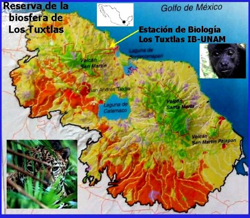
In a recent post, we looked at an Enchanted Lake in southern Mexico, in the Sierra de las Tuxtlas, near Catemaco in the Gulf Coast state of Veracruz. In this post we take a look at the surrounding Las Tuxtlas Biosphere Reserve.

Tuxtlas biosphere reserve

Scenically, the entire Tuxtlas region is one of the most fabulously beautiful in all of Mexico. High temperatures combined with lots of rainfall result in luxuriant vegetation and boundless wildlife. Average monthly temperatures range from a pleasant 21 degrees C (70 degrees F) in January to a high of 28 degrees C (82 degrees F) in May, just before the rainy season kicks in. During the rainy season, from June to October, some 2000 mm (79 inches) of rain falls, often in late afternoon tropical deluges.

The jungle masking the lower slopes of the San Martín volcano gradually merges into tropical cloud forest at higher altitudes. Competing with the Silk Cotton (Kapok) and Ficus trees for light and sustenance are ground-hugging ferns. Overhead, the tangle of tree branches provides support for thousands of non-parasitic bromeliads (“air” plants) and orchids. More than 1300 species of flowering plants have been identified in this classic area for Neotropical ecology.

Bird-watchers are likely to spot the spectacular Keel-billed Toucan, or hear a Tody Motmot. Smaller birds include several species of hummingbird; look for the endemic Long-tailed Sabrewing. About half of all the bird species recorded in Mexico have been seen here, but birds are not the only wild animals inhabiting the jungle. Ocelots and tapirs are regularly seen and you may be lucky enough to see spider monkeys playing overhead in the canopy.

Clearance of the land for grazing and cultivation of the slopes to grow tobacco, bananas and sugar cane have reduced the original jungle to a relatively small number of isolated fragments. Fortuitously, this provides more varied habitats than the original vegetation, helping to enrich the area’s wildlife, further enhancing the region’s reputation as an ornithological and botanical paradise.

Fortunately an extensive area of this region was declared a Biosphere Reserve in 1998, ensuring that conservation programs now go hand-in-hand with human activities. The total area forming the Reserva de la Biósfera “Los Tuxtlas” is 155,122 hectares (380,000 acres).

Chapter 5 of Geo-Mexico: the geography and dynamics of modern Mexico focuses on Mexico’s ecosystems and biodiversity.  Chapter 30 analyzes environmental issues and trends including current environmental threats and efforts to protect the environment.  Buy your copy today to have a handy reference guide to all major aspects of Mexico’s geography!

The diversity of species (plants and animals) in Mexico

 Other  Comments Off on The diversity of species (plants and animals) in Mexico
Oct 152010
 

A previous post noted that Mexico’s very wide range of ecosystems make it one of the six most biodiverse countries on earth. We also looked at the states in Mexico with the greatest biodiversity.

Given its deserts, it is not surprising that Mexico ranks first in the world in cactus species and second in reptile species, behind only Australia. Mexico’s tallest cactus is the Pachycereus pringlei (cardón), a relative of the saguaro. It can grow to a height over 19 meters (60 feet) and 1 meter in diameter (39 inches). The largest reptile is the crocodile which can grow to 5 meters (16 feet) in length and weigh over 400 kilograms (880 pounds).  In recent years, several Mexicans have been killed by crocodile attacks.

Marine biodiversityLargely as a result of Mexico’s diverse tropical and subtropical forests, Mexico ranks fourth in the world with 30,000 different types of flowering plants, compared to only 18,000 in the USA and 12,000 in all of Europe. It also ranks fourth in number of amphibian species, which thrive in Mexico’s tropical rainforests. Mexico is also among the top ten in fern and butterfly species.

The temperate forests also harbor significant biodiversity.  Mexico has more species of pine trees and oak trees than any other country.  However, with deforestation, some of these species may be endangered.

Most people are very surprised to learn that Mexico is among the top three in mammal species, along with Indonesia and Brazil. Some of Mexico’s mammals are majestic like the jaguar, some are rather large like the tapir, but many are small and less impressive like bats, shrews, and rodents. Extinction of endemic Mexican mammals is a serious concern. The International Union for Conservation of Nature (IUCN) has listed 11 endemic Mexican mammals as “critically endangered”; 27 as “endangered”, and 14 as “vulnerable”.

Chapter 5 of Geo-Mexico: the geography and dynamics of modern Mexico focuses on Mexico’s ecosystems and biodiversity.  Chapter 30 analyzes environmental issues and trends including current environmental threats and efforts to protect the environment.  Buy your copy today to have a handy reference guide to all major aspects of Mexico’s geography!

Oct 122010
 

Q. Mexico is one of the six most biologically diverse countries on the planet.  But which states in Mexico have the greatest biodiversity?

A. In general, the southern states (which receive the highest amounts of rainfall) have the greatest biodiversity: Chiapas, Oaxaca, and Veracruz.

The three most biodiverse states in Mexico

The three most biodiverse states in Mexico

To answer this question in more detail, it is useful to look at different types of plants and animals.

Mammal species are fairly well distributed throughout Mexico. Three of the wettest states lead in number of mammal species.  Chiapas has 205 different species followed by Oaxaca (194) and Veracruz (190). Interestingly, the next highest rated states are in central and northern Mexico: Jalisco (173), Michoacán (163), San Luis Potosí (152), Tamaulipas (145), Puebla (144), Durango (141) and Sonora (139). All states have over 70 mammal species, except for the relatively small states of Aguascalientes (40), Tlaxcala (50) and Guanajuato (65). Mexico as a whole has an impressive 901 mammal species; this figure places it ahead of all other countries.

Mexico is a bird watchers paradise. Veracruz and Oaxaca lead with 635 and 634 different bird species. Chiapas is third with 565 bird species followed by Sonora (445), Jalisco (438), San Luis Potosí (438), Tamaulipas (435) and Michoacán (429). Tlaxcala (86) and Aguascalientes (88) have the fewest number of bird species.

Mexico’s 808 different reptile species places it second, behind only Australia. Relative wet states lead in number of reptile species: Oaxaca (258), Chiapas (224), Veracruz (214) and Guerrero (158). However, the more arid states also have relatively large numbers of reptile species: Sonora (137), Chihuahua (118), Baja California (80) and Baja California Sur (68). Aguascalientes has only 17 reptile species.

Amphibians are very abundant in the wet southeastern states. Chiapas leads with117 amphibian species in followed by Veracruz (109), Oaxaca (106) and Hidalgo (66). Not surprisingly, there are very few amphibian species in desert states. Baja California Sur has only five species while Baja California has 12.

Mexico ranks fourth in the world in number of flowering plant species, behind only Brazil, Colombia and China. Veracruz is the clear leader with 4,907 species, followed by Chiapas (3,833), Oaxaca (3,388) and Jalisco (2,752). States with the fewest species are Aguascalientes (467), Tlaxcala (457) and Baja California Sur (484).

Mexico is also among the world leaders in number gymnosperm (nonflowering plants – mostly conifers and other evergreens) species.  Mexico has more species of pine trees than any other country. Veracruz leads with 31 species, followed closely by Nuevo León (30), Durango (29), Oaxaca (28), Hidalgo (27) and Chihuahua (26). Quintana Roo and Campeche have only one species while Colima and Yucatán have only two.

Ferns are also an important part of Mexico’s biodiversity. Chiapas leads with 693 fern species, followed by Oaxaca (669), Veracruz (534), Guerrero (374) and Puebla (297). States on the Yucatán Peninsula have relatively few fern species: Yucatán (25), Campeche (29) and Quintana Roo (39).

Source for the statistics in this post: Semarnat, El ambiente en números 2010, tabla 21: “Riqueza de grupos de species selecionadas, 2008” (CONABIO) (pdf document).

Several of our previous posts have discussed Mexico’s very wide range of climates, ecosystems and species diversity:

Chapter 5 of Geo-Mexico: the geography and dynamics of modern Mexico focuses on Mexico’s ecosystems and biodiversity.  Chapter 30 analyzes environmental issues and trends including current environmental threats and efforts to protect the environment.  Buy your copy today to have a handy reference guide to all major aspects of Mexico’s geography!

Mexico’s mega-biodiversity

 Other  Comments Off on Mexico’s mega-biodiversity
Oct 122010
 

People from elsewhere generally think of Mexico as an arid country with lots of cacti. The general impression is that Mexico has relatively little biodiversity in comparison with equator-hugging tropical countries such as Brazil and Indonesia.

These impressions could not be farther from the truth.  While northern Mexico is indeed arid, many areas in southern Mexico receive over 2,000 mm (80 inches) of annual precipitation, almost entirely in the form of rainfall. The rainiest place in Mexico— Tenango, Oaxaca—receives 5,000 mm (16.4 feet) of rain annually.

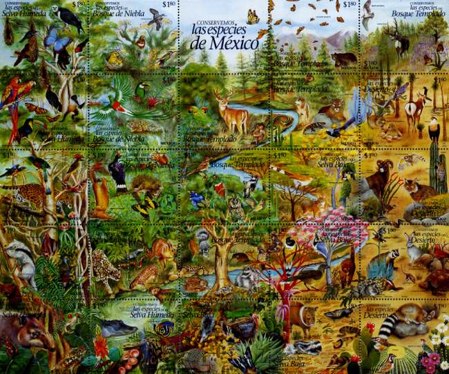
Mexico's postage stamps regularly celebrate biodiveristy

Mexico's postage stamps regularly celebrate biodiveristy. Click to enlarge

Straddling the Tropic of Cancer, Mexico is a world leader in terms of climate and ecosystem diversity.  It is one of the only countries on earth with arid deserts, dry scrublands, temperate forests, high altitude alpine areas, subtropical forests, tropical rainforests and extensive coral reefs. The multitude of ecosystems in Mexico supports a very wide range of biodiversity.

  • Mexico’s vegetation zones. The link is to a pdf map (in color) of vegetation zones. The map (all rights reserved) is a color version of Figure 5.1 in Geo-Mexico.

Mexico’s Environmental Ministry (SEMARNAT) indicates that there are over 200,000 different species in Mexico.  This is about 10% – 12% of all the species on the planet. About half of all Mexico’s species are endemic; they exist only in Mexico. An unknown number of endemic species were forced to extinction by the intended and unintended importation of Old World species by the Spaniards.

The U.N. Environment Programme has identified 17 “megadiverse” countries.  The list includes Mexico, the USA, Australia, five South American countries, three African countries, and six Asian counties.  Actually, Mexico is among the upper third of this group along with Brazil, Colombia, China, Indonesia and DRC (Democratic Republic of the Congo). The other countries on the list are: the USA, Venezuela, Ecuador, Peru,  South Africa, Malagasy Republic, India, Malaysia, The Philippines,  Papua New Guinea, and Australia.

Chapter 4 of Geo-Mexico: the geography and dynamics of modern Mexico discusses Mexico’s diverse climates.  Chapter 5 focuses on ecosystems and biodiversity.  Chapter 30 analyzes environmental issues and trends including the impact of Old World species imported by the Spaniards, current environmental threats, and efforts to protect the environment.  Buy your copy today to have a handy reference guide to all major aspects of Mexico’s geography!

Sep 092010
 

In two previous posts, we examined the historical connections between Mexico and the Philippines.

A news story (on mb.com.ph) a few months ago alerted us to another, much more recent link between the two countries.

The Philippine Drug Enforcement Agency (PDEA) claims that a Mexican herb poses a significant public health risk. According to the PDEA, Salvia divinorum, which is hallucinogenic when sun-dried leaves are chewed, sniffed or smoked, has been found growing wild in the Teachers Village in Quezon City. The plant is a member of the mint family and has a distinctive square stem. It is not known how or when it was introduced into the Philippines.

It is endemic to the remote region of the Sierra Mazateca in the northern part of the state of Oaxaca, Mexico. The plant grows in the warm, damp tropical evergreen and cloud forests at elevations between 300 and 1800 meters (1000 to 6000 feet). Biologists remain uncertain whether the plant is a truly natural plant or whether it is actually a hybrid (a cross between two or more distinct plant species) or cultigen (a plant that has been deliberately altered or selected by humans). It is commonly known in Mexico as divine sage, and the local Mazatec indigenous group has a long tradition of employing the plant in spiritual healing ceremonies.

The active constituent of Salvia divinorum is known as salvinorin A. Wikipedia’s entry on divine sage claims that “By mass, salvinorin A is the most potent naturally-occurring psychoactive compound known.”

We are not sure why it is in the interests of the PDEA to offer helpful tips for anyone thinking of growing and using this particular plant, but a PDEA spokesperson did just that, describing the plant as being somewhat similar to cannabis (marijuana), but easier to grow, since it can be propagated via stem cuttings. In addition, “The addictive effect of the said plant will last long if the leaves of the plant will be spread on a person’s gums rather than sniffing or puffing it like a cigarette. They say it gives you an uncontrollable laugh trip because the user will see the people as if they were caricatures or cartoons.” At least the final part of that quote appears to be hearsay and probably not admissible if introduced into a courtroom!

Despite its known hallucinogenic qualities, the cultivation and possession of divine sage remain legal in almost every country around the world. In the USA, only certain states have criminalized the plant. Click here for a webpage which provides more details of divine sage’s legal situation in particular countries and US states.

In the Philippines, the PDEA is reported to be collecting further evidence prior to recommending whether or not owning the plant should be made illegal. Sounds like it could be a fun job if you can get it!

Divine sage is the latest link in the 450-year-long history of close connections between Mexico and the Philippines.

Mexico’s links with other countries are discussed in chapter 20 of Geo-Mexico: the geography and dynamics of modern Mexico. Ask your library to buy a copy of this handy reference guide to all aspects of Mexico’s geography today! Better yet, order your own copy…

Mexico’s first cooks and the origins of Mexican cuisine

 Other  Comments Off on Mexico’s first cooks and the origins of Mexican cuisine
Jun 182010
 

Mexican cuisine has been one of the country’s most successful cultural exports over the past twenty years or so and most large towns in North America and Europe now boast at least one Mexican restaurant, even if the menu is not necessarily “authentic”. For those wanting to experiment, the basic ingredients for Mexican meals can now be bought virtually everywhere. The increasing popularity of Mexican food has been rivaled only by an extraordinary increase in the consumption of Mexican drinks, including Corona beer and tequila.

Ingredients for guacamole. Photo: Chef Daniel Wheeler. All rights reserved.

Archaeologists have also taken much more interest in Mexican food in recent years.

By 1970, studies carried out at various locations, ranging from Tamaulipas in the north of the country to Oaxaca in the south, had gradually led to the conclusion that the earliest plants to be domesticated in Meso-America were corn, beans and squash, and that all three had been domesticated between about 7000 and 10,000 years BP (Before Present, not British Petroleum…).

Further research subsequently led most archaeologists and palaeo-botanists to believe that squash was actually domesticated much earlier than corn. Re-evaluating cave samples, originally collected in the 1950s, using an improved carbon-14 dating technique, anthropologist Bruce Smith found that the squash seeds from one location were between 8,000 and 10,000 years old, while the oldest corn and bean seeds were much younger, less than 6,000 years old.

While Smith’s study does appears to confirm that squash was domesticated first, it does not necessarily mean that this squash was domesticated for its food value. Many experts think that early varieties of squash may have been domesticated primarily for their gourds, which could be used as ready-made drinking vessels and fishing floats.

The domestication of squash may have improved life, but it did not fundamentally change it. On the other hand, the eventual domestication of corn, about 7,000 years BP marked a true watershed in pre-Hispanic life, enabling the abandonment of a nomadic hunter-gathering existence in favor of settlement in semi-permanent villages. How important was this? In the words of renowned archaeologist Michael Coe, “it was the cultivation of maize, beans and squash that made possible all of the higher cultures of Mexico.”

With the passing of time, the ancient peoples of Mexico domesticated and cultivated many other native plants, including tomatoes, chiles, potatoes, avocados, amaranth, chayote (vegetable pear), cotton and tobacco.

The original article on MexConnect

If you enjoyed this post, you might also enjoy Geo-Mexico: the geography and dynamics of modern Mexico.

Las Tuxtlas Biosphere Reserve in Veracruz, Mexico

 Other  Comments Off on Las Tuxtlas Biosphere Reserve in Veracruz, Mexico
Apr 172010
 

Scenically, the entire Tuxtlas region, in the south-eastern section of the  state of Veracruz, is one of the most fabulously beautiful in all of Mexico. High temperatures combined with lots of rainfall result in luxuriant vegetation and boundless wildlife. Average monthly temperatures range from a pleasant 21 degrees C (70 degrees F) in January to a high of 28 degrees C (82 degrees F) in May, just before the rainy season kicks in. During the rainy season, from June to October, some 2000 mm (79 inches) of rain falls, often in late afternoon tropical deluges.

The jungle masking the lower slopes of the San Martín volcano gradually merges into tropical cloud forest at higher altitudes. Competing with the Silk Cotton (Kapok) and Ficus trees for light and sustenance are ground-hugging ferns. Overhead, the tangle of tree branches provides support for thousands of non-parasitic bromeliads (“air” plants) and orchids. More than 1300 species of flowering plants have been identified in this classic area for Neotropical ecology.

Bird-watchers are likely to spot the spectacular Keel-billed Toucan, or hear a Tody Motmot. Smaller birds include several species of hummingbird; look for the endemic Long-tailed Sabrewing. About half of all the bird species recorded in Mexico have been seen here, but birds are not the only wild animals inhabiting the jungle. Ocelots and tapirs are regularly seen and you may be lucky enough to see spider monkeys playing overhead in the canopy.

Clearance of the land for grazing and cultivation of the slopes to grow tobacco, bananas and sugar cane have reduced the original jungle to a relatively small number of isolated fragments. Fortuitously, this provides more varied habitats than the original vegetation, helping to enrich the area’s wildlife, further enhancing the region’s reputation as an ornithological and botanical paradise.

Fortunately an extensive area of this region was declared a Biosphere Reserve in 1998, ensuring that conservation programs now go hand-in-hand with human activities. The total area forming the Reserva de la Biósfera “Los Tuxtlas” is 155,122 hectares (380,000 acres).

Click here for original article on MexConnect

Mexico’s varied climate zones are discussed in chapter 4 of  Geo-Mexico: the geography and dynamics of modern Mexico, while chapter 5 is devoted to Mexico’s ecosystems and biodiversity, including the nation’s many biosphere reserves.

Apr 122010
 

Many common garden flowers were developed from samples collected in Mexico by a German botanist financed by Britain’s Horticultural Society.

Karl Theodor Hartweg (1812-1871) came from a long line of gardeners and had gardening in his genes. Born in Karlsruhe, Germany, he worked in Paris, at the Jardin des Plantes, before moving to England to work in the U.K. Horticultural Society’s Chiswick gardens in London. Keen to travel even further afield, he was appointed an official plant hunter and sent to the Americas for the first time in 1836. What was originally intended to be a three-year project eventually became an expedition lasting seven years.

By Hartweg’s time, Europeans already knew that Mexico was a veritable botanical treasure trove, full of exciting new plants. For example, the humble dahlia, a Mexican native since elevated to the status of the nation’s official flower, had already become very prominent in Europe. Mexican cacti were also beginning to acquire popularity in Europe at this time.

The Horticultural Society saw both academic and financial potential in sponsoring Hartweg to explore remote areas of Mexico, and collect plants that might flourish in temperature climes such as north-west Europe.

Fuchsia fulgens

Fuchsia fulgens

Hartweg proved to be an especially determined traveler, who covered a vast territory in search of new plants. He collected representative samples and seeds of hundreds and hundreds of species, many of which had not previously been scientifically named or described. Orchids from the Americas were particularly popular in Hartweg’s day. According to Merle Reinkka, the author of A History of the Orchid, Hartweg amassed “the most variable and comprehensive collection of New World Orchids made by a single individual in the first half of the [19th] century”.

Shortly after arriving in Veracruz in 1836, Hartweg met a fellow botanist, Carl Sartorius (1796-1872), of German extraction, who had acquired the nearby hacienda of El Mirador a decade earlier. Sartorius collected plants for the Berlin Botanical Gardens. His hacienda, producing sugar-cane, set in the coastal, tropical lowlands, became the mecca of nineteenth century botanists visiting Mexico.

From 1836 to 1839, Hartweg explored Mexico, criss-crossing the country from Veracruz to León, Lagos de Moreno and Aguascalientes before entering the rugged landscapes around the mining town of Bolaños in early October 1837. In his own words, reaching Bolaños had involved “travelling over a mountain path of which I never saw the like before”, one “which became daily work by the continual heavy rains.” From Bolaños, Hartweg visited Zacatecas, San Luis Potosí (in February 1838) and Guadalajara, where he did not omit to include a detailed description of tequila making. From Guadalajara, he moved on to Morelia, Angangueo [then an important mining town, now the closest town of any size to the Monarch butterfly reserves], Real del Monte, and Mexico City, from where he sent a large consignment of plant material back to England. Hartweg then headed south to Oaxaca and Chiapas en route to Guatemala, Ecuador, Peru and Jamaica. He arrived back in Europe in 1843.

Hartweg visited Mexico again in 1845-46.  After arriving in Veracruz in November 1845, he traversed the country via Mexico City (early December) to Tepic, where he arrived on New Year’s Day 1846, to wait for news of a suitable vessel arriving in the nearby port of San Blas which could take him north to California. In the event he had to wait until May, so he occupied himself in the meantime with numerous botanical explorations in the vicinity, including trips to Ceboruco Volcano. From California, he sent further boxes of specimens back to England, including numerous plants which would subsequently become much prized garden ornamentals. During this trip, he also added several new conifers to the growing list found in Mexico. It is now known that Mexico has more of the world’s 90+ species of pine (Pinus) than any other country on earth. This has led botanists to suppose that it is the original birthplace of the entire genus.

It took several years for the boxes and boxes of material sent back to England by Hartweg to be properly examined, cataloged and described. Many of the samples from his early trip were first described formally by George Bentham in Plantae Hartwegianae, which appeared as a series of publications from 1839 to 1842. Among the exciting discoveries were new species of conifers, such as Pinus hartwegii, Pinus ayacahuite, P. moctezumae, P. patula, Cupressus macrocarpa, and Sequoia sempervirens. Hartweg’s collecting prowess is remembered today in the name given to a spectacular purple-flowering orchid, Hartwegia purpurea, which is native to southern Mexico.

Numerous garden plants derive directly from plants Hartweg sent back to Europe. These included Salvia patens (a blue flowering member of the mint family) which became the ancestor of modern bedding salvias, the red-flowering Fuchsia fulgens, ancestor of a very large number of Fuchsia cultivars, and the red-flowering Zauschneria californica, commonly known as California fuchsia.

Original article on MexConnect

The Irish may be everywhere, but mainly due to a Mexican water mold

 Other  Comments Off on The Irish may be everywhere, but mainly due to a Mexican water mold
Mar 172010
 

During the Irish potato famine more than one million people died of starvation when their staple crop failed, and many of those who survived were forced to emigrate. This tide of emigration carried many Irish people to North America, particularly to the north-east of the USA.

How did the potato famine come about? The census of 1841 in Ireland recorded a population of about 8 million. This figure was a staggering 300% more than sixty years earlier. The staple Irish food at that time was the humble potato and Ireland’s rapid population growth during the early part of the nineteenth century was based on the so-called “potato economy”.  Ireland was bursting at the seams in 1841, but just a decade later, after the potato famine, the population had fallen to 6.5 million and by 1900 to around 4 million.

And where does a Mexican mold come in? The cause of famine was a water mold (Phytophthora infestans) that originated in Mexico. This fungus-like mold results in a disease called “late blight” in which entire fields of mature potato plants are destroyed within days. The name “late blight” is because the mold strikes late in the growing season, close to harvest time. Infected tubers are subject to soft-rot bacteria which render them useless as food. What is worse, the discarded rotting tubers can easily re-infect the succeeding year’s crop.

One kind of late blight mold, A1, crossed the Atlantic in the 1840s, reaching Europe in 1845 before rapidly spreading across the continent to reach Ireland. Although cultivated potatoes (Solanum tuberosum) originated in Peru, the late blight mold appears to have originated in the Toluca Valley of Mexico (adjacent to the western edge of Mexico City) where it is found in several related wild-growing Solanum tubers.

After the Irish potato famine, farmers learned to control the A1 mold through careful fungicide applications and by choosing varieties that had some resistance to late blight and planting only healthy tubers.

Since the 1980s, however, farmers are once again fighting late blight as the direct result of the escape of a second kind, A2, into the cultivated potato population. The problem stems from the fact that A1 and A2 can reproduce sexually, with the potential to have offspring that are strains with greater virulence or increased resistance to fungicides. Having two different kinds of late blight as parents greatly magnifies the genetic variability available for future generations of the mold .

The A2 mold first appeared outside Mexico in the 1970s and has already spread with serious economic consequences to the Middle East, Africa and North and South America. It seems almost certain that it will eventually also disrupt harvests in India and in China, the world’s largest potato producer. The A2 mold is considered the most important threat to potato cultivation worldwide. The current response of hitting it with higher and more lethal doses of fungicide is not in line with public demands for greener farming methods.

How did the A2 mold escape from Mexico? It was probably unintentionally carried by potatoes exported to Europe during the winter of 1976-77. Europe needed potatoes because a drought a year earlier had reduced its potato yields significantly. Unrecognized, the mold was then re-transported in seed potatoes throughout Europe and to the Middle East and Africa.

Scientists are studying wild potatoes in the Toluca Valley in an effort to try and identify precisely which gene or combination of genes provides these particular wild potatoes with some degree of defense against the worst ravages of the mold. Mexico’s main center for potato research is the Agricultural University at Chapingo, near Texcoco, on the eastern edge of Mexico City. The University is well worth a visit – if only to admire the magnificent Diego Rivera murals, including one of the world’s great nudes.

Happy St. Patrick’s Day, wherever you may be!

This is an edited version of an article originally published on MexConnect – Click here for the original article

Mexico’s innumerable links (economic, social, demographic and cultural) to the world are relevant to many chapters of Geo-Mexico: the geography and dynamics of modern Mexico.

Mar 142010
 

Rubber balls wouldn’t bounce very high at all if it wasn’t for some Mexican ingenuity. Think of the hours of pleasure that a simple rubber ball gave you as a child. Would you have had as much fun if it hadn’t bounced? I don’t think so… but what’s the secret ingredient?

It has long been known that the pre-Columbian peoples of Mexico had rubber objects, including balls. The basic ingredient was the sap or latex of the native Panama Rubber Tree (Castilla elastica).

A few years ago, Dorothy Hosler, an associate professor of archeology and ancient technology at the Massachusetts Institute of Technology, and two of her colleagues, chemist Sandra Burkett and undergraduate student Michael Tarkanian, realized that unprocessed pure latex is sticky and becomes brittle when dry. Put simply, balls made of pure latex don’t bounce, but shatter.

So, they then set out to tackle the mystery of what makes rubber balls bounce. In a landmark paper entitled, “Prehistoric Polymers: Rubber Processing in Ancient Mesoamerica,” published in the June 18, 1999, issue of Science, they revealed how a little Mexican ingenuity turned sticky, brittle latex into a stretchy elastic. Put simply, they revealed what made rubber balls bounce.

The magic ingredient is a little sap from the Morning Glory (Moonflower) vine! The addition of sap to latex begins complex chemical changes that provide a much improved material for tools, figurines and medicines, in a process akin to vulcanization, invented three thousand years later by Charles Goodrich. The addition of Morning Glory (Ipomoea alba) sap to otherwise brittle rubber also resulted in balls suitable for the development of Mexico’s ancient sport of Ulama.

Ipomoea alba, the tropical white-flowering morning glory (moonflower or moon vine).

How did Hosler’s team arrive at this startling conclusion? Documentary sources and ethnographic research suggested that Indians mixed natural latex with the juice of the morning glory vine, a plant prized for its curing properties. The researchers crushed some Morning Glory vines and squeezed the juice into a bucket containing the latex. After stirring for 15 minutes, the liquid latex solidified into a white mass, pliable enough to be formed by hand into a ball. The researchers made a ball about 3.7 inches (9.5 cm) in diameter and, lo and behold, it bounced!

When they used nuclear magnetic resonance scans to examine rubber balls dating back to 1600 B.C. that had been found in Veracruz and Chiapas, they were able to conclude that these had been made in a similar way.

Is it really surprising that pre-Columbian Indians discovered this chemical trick thousands of years ago? Well, perhaps not as surprising as you may think, since the two plants, Castilla elastica and Ipomoea alba often grow in close proximity. In fact, the Morning Glory vine often twines itself around the rubber tree, making it quite likely that a careless rubber tapper accidentally contaminated the latex being collected with a little (crushed) Morning Glory vine: an accident that turned out to have incredibly serendipitous results.

Whatever happened all those thousands of years ago, the mystery of why rubber balls bounce has finally been solved…

This is an edited version of an article originally published on MexConnect – Click here for the original article

Sports are not specifically discussed in Geo-Mexico, but the music, dance, language and cuisine of Mexico, together with cultural regions, are discussed in chapter18 of Geo-Mexico: the geography and dynamics of modern Mexico.