Geography, residence patterns and architecture in the mining town of Santa Rosalía, Baja California Sur

 Other  Comments Off on Geography, residence patterns and architecture in the mining town of Santa Rosalía, Baja California Sur
Mar 092017
 

In a previous post — The re-opening of the giant El Boleo copper mine in Santa Rosalía, Baja California Sur —  we looked at the repeated boom-bust-boom history of the copper mining center of Santa Rosalía on the Baja California Peninsula. The arid peninsula did not offer much in the way of local resources for the construction of a mining settlement. When mining took off, an entire town was needed, virtually overnight. Almost all the materials necessary for the construction and exploitation of the mines and for building the houses and public buildings had to be imported, primarily from the USA.

As the town grew at the end of the nineteenth century, a clear geographic (spatial) segregation developed, which is still noticeable even today:

  • Workers’ homes were built on the lowland near the foundry and port
  • Higher up the slope was the Mexican quarter where government workers and ancillary support staff lived
  • The highest section of town, overlooking everything, was the French quarter.

The contrasts of Santa Rosalía at this time were well summed by María Eugenia B. de Novelo:

“Santa Rosalía was a place of clashing contrasts and situations. It had a scarred backdrop of copper hills, a black-tinted shore, French silks, fine perfumes, crystal, Bordeaux wines and Duret cooking oil, sharing the scene with flour tortillas, giant lobsters, abalone and chimney dust.”

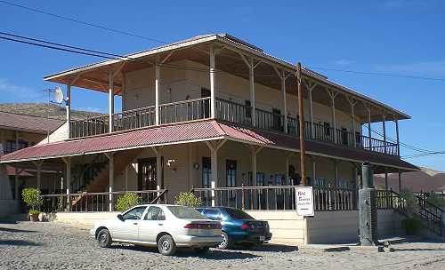
The French quarter has retained its distinctive architecture to the present day. At one end is the Hotel Francés, opened in 1886, which has an incredibly stylish period interior and still operates today.

Hotel Francés, Santa Rosalía

Hotel Francés, Santa Rosalía. Photo: Tony Burton

The gorgeous architecture of many of the homes of the French quarter is reminiscent of New Orleans. Beautiful wooden houses stand aloof on blocks with porches, balconies and verandas, competing for the best view over the town below. Wooden homes are decidedly unusual in this part of Mexico, which was never forested, and are, indeed, rare almost everywhere in the country. There are so many wooden homes here that Santa Rosalía has long had its own fire department, just in case!

At the other end of the French quarter are the former mining offices, now the Museo Boléo, an interesting museum where interior details are little changed from a century ago. Standing in the main hall, it is possible to imagine the hustle and bustle of former days, as clerks work feverishly to keep up with their superiors’ numerous demands. The mining company attracted workers from far afield. Three thousand Chinese workers arrived, settling the districts still known as La Chinita and Nuevo Pekin.

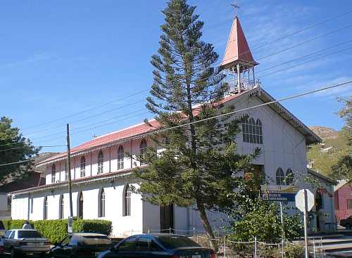
The most conspicuous landmark in the main part of town remains the former foundry, no longer open to the public. The next most conspicuous landmark is the church of Santa Bárbara. There are serious doubts as to who designed this unusual church, assembled out of pre-fabricated, stamped steel sheets or plates. Most guidebooks attribute the church to Gustave Eiffel, the famous French architect responsible for the Eiffel Town in Paris. According to this version, Eiffel’s design won a prize at the 1889 Universal Exposition of Paris, France, and was originally destined for somewhere in Africa. It was later discovered in Belgium by an official of the Boleo mining company, who purchased it and brought it back to Santa Rosalía in 1897.

The church of Santa Rosalía

The church of Santa Rosalía. Photo: Tony Burton.

The latter part of the story may be correct, but research by Angela Gardner (see Fagrell, 1995) strongly suggests that the original designer was probably not Eiffel but is far more likely to have been a Brazilian, Bibiano Duclos, who graduated from the same academy as Eiffel in Paris. Duclos took out a patent on pre-fabricated buildings, whereas there is no evidence that Eiffel ever designed a pre-fabricated building of any kind. Whoever designed it, it is certainly a unique design in the context of Mexico, and well worth seeing.

Other well-preserved buildings dating back to the heyday of the town’s success include the municipal palace or town hall (formerly a school designed by Gustave Eiffel), the Central Hotel, the DIF building, the Club Mutualista, the Post Office and the Mahatma Gandhi library, currently being restored. The library is in Parque Morelos, which is also the last resting place for a Baldwin locomotive dating back to 1886.

If walking around town looking at the architecture makes you hungry, try the French pastries (and Mexican sweet breads) from the Panadería El Boleo on the main street. With slight hyperbole, Panadería El Boleo boasts on its wall of being the World’s most famous bakery. Expect to queue, but enjoy the smells of fresh baked goods while you wait.

The distinctive history, architecture (and pastries) of Santa Rosalía, assuming they are conserved, should prove in the future to be an excellent basis for the development of cultural tourism to supplement the ecotourism and adventure tourism already in place.

Sources:

Want to read more?

Note : This post was first published 11 October 2011.
Mexcaltitán, a magical island town in Nayarit

 Other  Comments Off on Mexcaltitán, a magical island town in Nayarit
Nov 102014
 

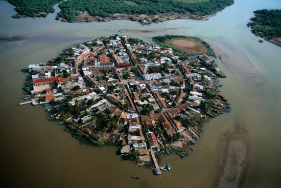
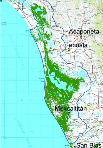
A short distance north of San Blas, in Nayarit, is a small island called Mexcaltitán. With barely four thousand inhabitants, it would scarcely be expected to have any real link to Mexico City, the world’s greatest metropolis of some twenty million people. But it does, and the link is to be found in the amazing story of the founding in 1325 of the Aztec capital Tenochtitlan, the city which was later conquered and sacked by the Spanish and rebuilt as Mexico City.

The island and village of Mexcaltián, Nayarit

The island and village of Mexcaltián, Nayarit

Historians have long wondered about the origins of the Mexica people, or Aztecs as they later became known. There is virtually no evidence of them before they founded the highly organized city of Tenochtitlan in 1325. Clearly such a civilization cannot just have sprung up overnight. So, where did they come from? Mexica (Aztec) legend tells of a long pilgrimage, lasting hundreds of years, from Aztlán, the cradle of their civilization, a pilgrimage during which they looked for a sign to tell them where to found their new capital and ceremonial center. The sign they were looking for was an eagle, perched on a cactus. Today, this unlikely combination, with the eagle now devouring a serpent, is a national symbol and appears on the national flag.

Map showing location of Marismas Nacionales

Map showing location of Marismas Nacionales

In recent years more and more evidence suggests that Aztlán may be far from mythical and that Mexcaltitán, the island in Nayarit, could be its original site. Ancient codices (pre-Columbian hand-painted manuscripts) prove that the Aztecs’ search for a new place to live was ordained by Huitzilopochtli, their chief god. It began in about AD1111 when they departed from an island in the middle of a lake. Their two hundred year journey took them through present-day Nayarit, Durango, Zacatecas, Jalisco, Michoacán, Guanajuato and Querétaro, and they may well have rested awhile on encountering familiar-looking islands in the middle of lakes such as Chapala and Pátzcuaro.

One of Huitzilopochtli’s alternative names was Mexitli and the current spelling of Mexcaltitán could be interpreted as “Home of Mexitli”, or thus, “Home of Huitzilopochtli”. In fairness, it should be pointed out that if the original spelling was Metzcaltitán (and “tz” often became transliterated to “x” down the centuries), then the meaning would become “Place next to the home of the Moon”.

Whatever the etymology of the name, early codices such as the Boturini Codex show the early Aztecs setting out from an Aztlán surrounded by water, in small canoes. The Mendoza Codex, depicting life in Tenochtitlan, has illustrations of similar canoes and, in both codices, the canoes and method of propulsion by punting show remarkable similarity to the present-day canoes of Mexcaltitán. Visitors to the island still have to undertake a canoe or panga ride to reach the village and it is an intriguing thought that the Mexica/Aztecs were doing exactly the same over eight hundred and fifty years ago.

Further evidence comes from an old map of New Spain. Drawn by Ortelius in 1579, it shows Aztlán to be exactly where Mexcaltitán is to be found today, though perhaps at the time this was largely conjecture.

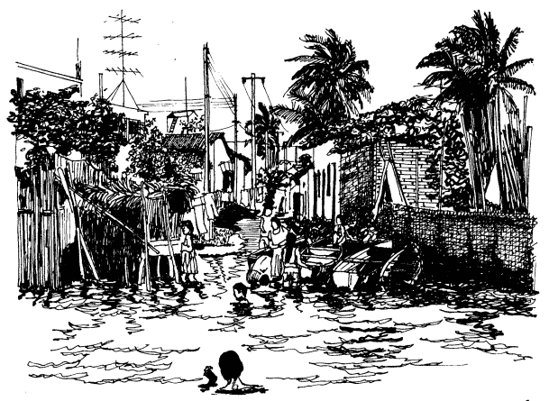
The street plan of Mexcaltitán, best appreciated from the air, is equally fascinating. Two parallel streets cross the oval-shaped island from north to south, and two from east to west, with the modern plaza in the middle, where they intersect. The only other street runs around the island in a circle, parallel to and not far from the water’s edge. This street may have been the coastline of the island years ago and may even have been fortified against the invading waters of the rising lake each rainy season. Today, as then, for several months in summer the streets become canals, bounded by the high sidewalks each side and Mexcaltitán becomes Mexico’s mini-Venice as all travel has to be by canoe.

This street pattern has cosmic significance. It divides the village into four quarters or sectors each representing a cardinal point, reflecting the Mexica conception of the world. The center can be identified with the Sun, the giver of all life. The Spanish, as was their custom, built their church there, and today the central plaza with its bandstand is the obvious focal point of the community. Small shops, a billiards hall, a modern, well-laid out museum, and an administrative office complete the central area of the village.


Mexcaltitán pen and ink drawing by Michael Eager

Mexcaltitán (pen and ink drawing by Michael Eager from chapter 26 of Western Mexico, A Traveler’s Treasury). All rights reserved.

Low houses, of adobe, brick and cement, line the dirt streets and extend right down to the water’s edge, in some cases even over the water’s edge into the surrounding lake, on stilts. Land on the island is at a premium and, with an ever-growing population, saturation point is very near.

A century ago, the locals turned on some foreigners who came to hunt female egrets, valued for their plumes back in the days when feathers adorned fashionable ladies’ hats. Today, provided only photos are taken, all visitors are welcomed! The villagers celebrate one of the most unusual and distinctive fiestas in all of Latin America. On 29 June each year they organize a regatta which consists of a single race between just two canoes, though naturally hundreds of other pangas are filled with spectators. One of the competing canoes carries the statue of Saint Peter from the local church, the other carries Saint Paul.

Elaborate preparations precede the race. The village streets are festooned with paper streamers and the two canoes are lavishly decorated by rival families carrying on an age-old tradition. The Ortíz family is responsible for St. Peter’s canoe, the Galindo family for St. Paul’s. The statues of the two saints are taken from the church and carried in procession to the boats. A pair of punters has previously been chosen from among the young men of the village for each boat. The punters have been suitably fortified for the contest with local delicacies such as steamed fish, shrimp empanadas, and the local specialty, tlaxtihuile, a kind of shrimp broth. Each boat, in addition to the punters and the statue of the saint, carries a priest to ensure fair play. The race starts from the middle of the eight kilometer long lake after a short religious service in which the priests bless the lake and pray for abundant shrimp and fish during the coming year. Then surrounding spectator canoes, some with musical bands, and others shooting off fireworks, move aside and the race begins.

Nowadays, St. Peter and St. Paul take it in turns to win, most considerate in view of the violence which years ago marred the post-race celebrations when the race was fought competitively. The ceremonial regatta safely over, land based festivities continue well into the night.

A canoe ride around the island takes about 30 minutes and provides numerous photo opportunities as well as many surprises including a close-up view of the island’s only soccer pitch—in the middle of the lake, under half a meter of water. The local children are, perhaps not surprisingly, expert “water soccer” players, a fun sport to watch.

Even if you’re not interested in the island’s past and are unable to see it on fiesta day, your trip to Mexcaltitán will be memorable. This extraordinary island and its village have to be seen to be believed.

The island is reached from the Tepic-Mazatlán highway, Highway 15. There are two alternatives. The northern route is signposted 73 kilometers north of Tepic; it starts with 26 kilometers of paved road crossing swampy paddy fields, followed by 16 kilometers of well-graded dirt road to Ticha, the landing-stage for boats to the island. The drive is through a naturalist’s paradise, teeming with wildlife. The equally scenic southern route begins 57 kilometers from Tepic and is via Santiago Ixcuintla (basic hotels only; don’t miss visiting the center for Huichol Indian culture and crafts) and Sentispac. It leads to the La Batanga landing-stage, and is fully paved.

Note:

This post is based on chapter 26 of my “Western Mexico: A Traveler’s Treasury” (link is to Amazon’s “Look Inside” feature), also available as a Kindle edition or Kobo ebook.

Related posts:

Empty houses in Mexico

 Other  Comments Off on Empty houses in Mexico
Apr 082013
 

On-going rural-urban migration has led to a proliferation of metropolitan areas and the construction of millions of new homes across Mexico. Thirty years ago, there were only 15 recognized metropolitan areas in Mexico, today there are 59.

In recent decades, there has been insufficient coordination between the various government departments responsible for housing, services and land development, such that some settlements were authorized even though they lacked or had inadequate access to highways or basic services. In many instances, settlements were given the green light even though the ownership of the land was still in dispute.

A recent Mexico City news report entitled Desorden urbano dejó en el país millones de viviendas fantasmas claims that this poor planning in Mexico has resulted in as many as 4 million houses, many of them newly built, standing empty.

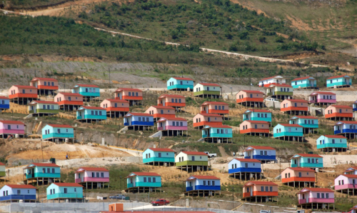
Among the settlements with a large number of uninhabited new homes is Santiago el Pinar in the heart of the southern state of Chiapas, home of the indigenous coffee–growing Tzotzil Indians who have traditionally lived in dispersed rural communities where access to central services is difficult. The previous federal administration built hundreds of homes here in its effort to “develop” the area into a “sustainable rural city” (whatever that means!). It was hoped that modern homes, located near services such a small, new hospital, would help give the Tzotzil a chance to escape poverty, though it did involve some relocation.

Santago el Pinar. Credit: glasgowchiapassolidaritygroup.wordpress.com

Santago el Pinar. Credit: glasgowchiapassolidaritygroup.wordpress.com

This BBC clip – Santiago el Pinar: One Square Mile of Mexico – describes the plan and some of the obstacles it has encountered.

The people’s traditional dwellings have dirt floors where food can be cooked over small fires. The new homes, designed by Marco Antonio Constantino, are mounted on stilts and have wooden floors, where traditional forms of indoor cooking would be hazardous. There were also some serious issues of construction quality, as well as a significant delay in supplying water to the new homes. All these factors combined have meant that almost all of the new homes have quickly been abandoned.

The lack of provision of basic services (water, electricity, drainage) is also cited as a factor why many new homes elsewhere in Mexico remain unoccupied.

In the past 20-30 years, Mexico’s largest homebuilders (companies such as Urbi, Geo and Homex) have done very well financially. They are now having to adjust to tougher times. Part of their problem, according to the Mexican financial press, is that government policy has shifted away from the construction of single-family units (such as those in Santiago de Pinar), which these big companies thrived on, towards building multi-family vertical units. The advantages of the latter are they reduce overall energy usage and the total cost associated with supplying other essential services.

This brief look at the issue of empty houses in Mexico suggests that while Mexico is certainly changing, and often for the better, change (as evidenced by Santiago de Pinar) is not necessarily synonymous with progress.

Want to read more?

Related posts:


The geography of the Huichol Indians: economy, lifestyles and settlements

 Other  Comments Off on The geography of the Huichol Indians: economy, lifestyles and settlements
Feb 072013
 

In this post we take a closer look at the traditional life and settlement patterns of the Huichol Indians.

The origins of the Huichol are unclear. The Wixárika themselves believe they arrived in the Jalisco-Nayarit area from the Valley of the Mexico, though most anthropologists believe it is more likely that they came originally either from the north or from the Nayarit coast.

Huichol economy and lifestyle

In the Huichol heartland area (shown on the map) the rainy season normally begins in June and lasts until October, a similar timing to most of central and western Mexico. While average temperatures in the area are usually between 15 and 20 degrees Centigrade, there can be sharp frosts in winter.

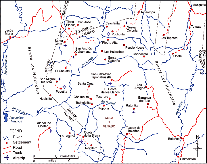
huichol-villages

The dispersed rural settlement pattern of the Huichol heartland. Credit: Tony Burton / Geo-Mexico; all rights reserved

Huichol family groups rely on the subsistence farming of corn, beans and squash, which are grown together in a small plot or garden (coamil). Tomatoes, chiles and gourds are also produced, Cultivation is often on steep slopes. Land is cleared by slash and burn. A few cattle may be kept, largely because of their value as trade items. Meat is rarely available except on ceremonial occasions. Some fishing is practiced, and wild plants also form part of the typical Huichol diet. Merchants supply other items such as salt, shells, feathers, canned drinks and sandals.

The typical Huichol home is a simple, one-room dwelling, usually rectangular in plan, with a thatched roof. Some homes have a second room for cooking.

The isolation of the Huichol has enabled them to retain almost all of their traditional customs. Anthropologists who have lived among the Huichol affirm that religion for the Huichol is not part of life, it is life.

Three of the most important symbols for the Huichol are deer, corn (maize) and peyote. In some ways, these three items underline the fact that the Huichol culture has undergone a transition from a lifestyle based on hunting and gathering towards one based on sedentary agriculture.

Settlements and districts

During colonial times, the area inhabited by the Huichol Indians was first divided into three and then, later, five administrative districts:

  • Santa Catarina (elevation about 1000 meters above sea level). Santa Catarina is a day’s walk from the nearest airstrip.
  • San Sebastián (elevation 1400 meters).
  • Tuxpan (aka Tuxpan de Bolaños; elevation 1060 meters).
  • San Andrés Cohamiata (elevation 1860 meters). This has the best airstrip and is the main Huichol ceremonial center. While many of the people did not adopt Catholicism, San Andrés has more services, including a medical clinic, and more working opportunities.
  • Guadalupe Ocotán (elevation 1050 meters). More of the Huichol living here accepted Catholicism and are more acculturated. Most children attend school; many people wear “mestizo” clothing.

Each of these districts has its own autonomous government, and there are relatively few formal links between the districts or “communities”. Each community is headed by a governor (Tatohuani), with the office transferred to a new leader every January following an elaborate ceremony. Each community also has a parallel religious government headed by its shamans (maraakames).

The transportation challenges in this region are evident from the number of small airstrips shown on the map and the paucity of road links. Villages only 5 or 10 kilometers away from each other “as the crow flies” may be almost impossible to travel between because of the river canyons and steep slopes. A relief map of this area shows that most settlements are perched on whatever flatter land is available, often on the plateau top.

Given the lack of formal links between districts, and the terrain, it is not surprising that the settlement pattern in the Huichol heartland area is highly dispersed, with a very large number of tiny settlements, mostly kinship settlements where all members belong to the same extended family. There are more than 400 distinct settlements (rancherías or ranchos) in the region and many of the settlements are a considerable distance from their nearest neighbors. This part of Mexico exhibits one of the clearest examples in the country of dispersed rural settlements.

Key questions raised by the dispersed settlement patterns of this area:

  • What does “development” mean in the context of the Huichol Indians?
  • Does this dispersed settlement pattern inhibit the future economic and social development of the Huichol people? If so, how does it do so, and what could be done to overcome the difficulties it causes?
  • Would development be easier if most or all of the small scattered communities were congregated into a smaller number of larger settlements?

Related posts:

The distinctive street pattern of Venta de Bravo, Michoacán

 Other  Comments Off on The distinctive street pattern of Venta de Bravo, Michoacán
Jan 262013
 

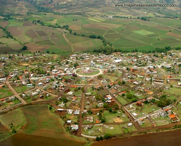
The small settlement of Venta de Bravo, in the municipality of Contepec in the state of Michoacán, has a very distinctive street pattern. As the image shows, it has a circular “center”, surrounded by a series of concentric circular streets (see image), connected via regularly-spaced radial streets. The regularity of the pattern is not quite perfect. Based on the photo, the imperfections probably result from variations of topography.

Venta de Bravo, Michoacán. Credit: imagenesaereasdemexico.com

Venta de Bravo, Michoacán. Credit: imagenesaereasdemexico.com

The village has about 1300 inhabitants and is at an elevation of 2290 meters above sea level. This is clearly a “planned settlement”, and one almost certainly quite modern in origin. I haven’t ever visited Venta de Bravo and don’t know its history, but would certainly be interested in finding out more if you have any pertinent information or can suggest likely sources.

An online search for Venta de Bravo will turn up numerous articles about the seismically active 45-km-long Venta de Bravo fault, as well as references to the small “Rayón National Park” which is only a few kilometers away in the Sierra of Tlalpujahua and extends as high as 2770 meters above sea level (Cerro del Gallo).

The geography of the Maya: does central place theory apply to ancient Maya settlements?

 Other  Comments Off on The geography of the Maya: does central place theory apply to ancient Maya settlements?
Oct 112012
 

An interesting historical example of central place theory is described in Ancient Mesoamerica: a comparison of change in three regions. Central place theory suggests that places of similar size (or occupying a similar level in a region’s urban hierarchy) should form a distinctive spatial pattern. They will be roughly equidistant from one another.The pattern is conceptualized as a series of hexagons, with a settlement at each apex. Such a pattern permits an equidistant spacing in all directions, and has no “gaps” where any territory falls outside (beyond) the “sphere of influence” of one or other of the settlements.

Several archaeologists interested in the Maya have suggested that central place theory offers a way to help explain the pattern of Maya sites in the Yucatán Peninsula and further south into Guatemala. They have postulated that Maya settlements may indeed form a hierarchy in terms of size and importance, with a relatively small number of major regional centers overseeing a larger number of smaller centers. Furthermore, where such a pattern exists, it suggests a high degree of political organization.

This particular example comes from the south-east corner of Campeche, near the Guatemala border.


The major regional center in this case is Calakmul (a World Heritage site since 2002). Calakmul is surrounded by six smaller centers, which are close to equidistant from each other, as well as from Calakmul. In turn, Uxul has several smaller subordinate settlements around it.

Settlement order around Calakmul in Classic Period (Blanton et al, 1981)

Settlement order around Calakmul in Classic Period (from Blanton et al, 1981; figure 4.11)

In this example, the average distance between settlements is about 33 kilometers (20.5 miles), which is approximately one day’s walk and/or canoe trip in this region. So, an individual could leave somewhere like Altamira in the morning and reach Calakmul before nightfall, and vice versa.

Not all Maya archaeologists believe that central place theory is helpful in explaining the distribution of settlements in the region. Some argue that the daily travel distance is the key, and that patterns such as that found around Calakmul are as much due to coincidence as any kind of overriding pattern.

The original theory, as proposed by German geographer Walter Christaller in 1933, was based on various assumptions. In particular, the region was assumed to be an unbounded isotropic (flat) plain, homogeneous in all significant physical aspects (soil, access to water, vegetation, etc), and population was assumed to be evenly distributed. The Yucatán Peninsula is certainly an area of low relief, but access to water and vegetation vary significantly from one area to another, so Christaller’s basic assumptions are not met in the region. On the other hand, there is no denying that a highly structured society might decide (even without having studied  AP Human Geography or A-level Geography) that regularly-spaced settlements are an ideal solution to issues of transportation, administration and control.

For a more academic discussion of the merits of central place theory in Maya research, see Brown and Witschey’s The Geographic Analysis of Ancient Maya Settlement and Polity [pdf file], a paper presented in 2001 at the Electronic Cultural Atlas Initiative, City University, Hong Kong.

Source:

Blanton, Richard E., Stephen A. Kowalewski, Gary Feinmann and Jill Appel. Ancient Mesoamerica: a comparison of change in three regions. Cambridge University Press, 1981.

Related posts:

Case study of a Tarahumara garden

 Books and resources  Comments Off on Case study of a Tarahumara garden
Sep 032012
 

A cave dwelling known as  “Cueva del Chino” is located a short distance from the Posada Barrancas railway halt, very close to the present-day location of the Posada Barrancas Mirador hotel. When I first visited this cave, in the mid-1980s, I was struck by the obvious dangers of living so close to a precipitous drop. The cave is on a very narrow ledge, some 20 meters or so below the canyon rim. There is a local spring which acts as a water supply, though it is perhaps not always a reliable year-round supply. Outside the cave is a tangle of vegetation, much greener and more varied than elsewhere along the canyon wall. It was only on my second or third visit to this cave that I realized that this unruly vegetation was not only due to the nearby natural water source, but also due to the assiduous work of the cave’s residents. The tangled vegetation was actually a very productive garden, offering a variety of vegetables, fruit and herbs.

Accustomed, as most of us are, to the idea of crops and plants in neat orderly rows, the mini-jungle in the cave’s small garden-farm may come as a surprise. But there are sound ecological (and economic) advantages to maintaining, and even encouraging, this apparent disorder. Among the major advantages of mixed cropping (sowing several different crops more or less at random in an area) are the following:

  • (a) some plants are perennial, others annual; hence a ground-cover is maintained all year and the likelihood of soil erosion is diminished
  • (b) taller plants provide shade for shorter plants, offering distinct microclimates within the garden
  • (c) some plants (legumes) help fix nitrogen in the soil; other plants need the nitrogen
  • (d) a variety of plants means a much more varied diet
  • (e) since different crops use different nutrients, the total yield off a small plot is greater with a mix of crops than with a single crop
  • (f) if disease or insects strike one plant, they may not be able to spread to the next plant of that kind
  • (g) if one crop fails for any reason, another may succeed; this may be enough to ward off starvation for another year
  • (h) in terms of energy efficiency, this is a very efficient system, since it involves relatively little labor; the output of energy will exceed the input (see The energy efficiency of farming in Mexico and elsewhere for more details)

Put simply, who really wants to work harder than necessary?

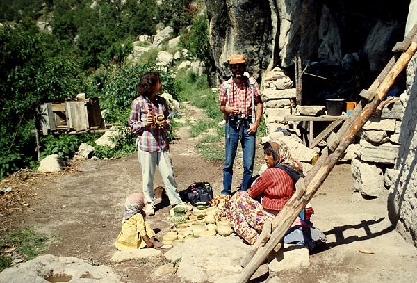
Cueva del Chino, 1989.Copyright Geo-Mexico; all rights reserved.

Cueva del Chino, with “garden” on the left, 1989.Copyright Geo-Mexico; all rights reserved.

Cueva del Chino, 2003.Copyright Geo-Mexico; all rights reserved.

Cueva del Chino, 2003 [from the opposite angle]. Copyright Geo-Mexico; all rights reserved.

The photos show the truly astonishing changes that took place in this cave dwelling and garden between 1989 and 2003. The major change in the area between those years was the construction of the Posada Barrancas Mirador, only a few steps away from the path leading down to the cave. This has led to a steady trickle of visitors who buy the locally-made pine needle basketwork (top photo) or leave behind a few pesos.

Are these changes really for the better? There are arguments on both sides, and I’m honestly not entirely sure. I haven’t been back for several years, but would welcome an update (and photo) from any Geo-Mexico reader who happens to visit.

Related posts:


The settlement patterns of the Tarahumara in Mexico’s Copper Canyon region

 Other  Comments Off on The settlement patterns of the Tarahumara in Mexico’s Copper Canyon region
Aug 132012
 

To understand the distinctive settlement patterns of the Tarahumara today, we first need to romp through a thumbnail history covering their experiences during the years following the Spanish Conquest.

While it is uncertain precisely when the Tarahumara arrived in this area, or where they came from, the archaeological evidence seems to support the view that they probably only arrived a short time before the Spanish reached the New World. By 1500 A.D., the Tarahumara had stone dwellings, simple blankets of agave fiber, stone “metates” (pestles), and combined hunting and gathering with the cultivation of corn (maize) and gourds. Settlements at this time would have been small and scattered, with no more than a few families able to survive in any given area. Then the Spanish arrived.

In early colonial times, Spanish explorers and clerics gradually moved ever further north of Mexico City. The first twelve Jesuits had arrived in New Spain in 1572; more arrived in 1576 and by 1580, they had already established centers for their work in Michoacán (1573), Guadalajara (1574), Oaxaca (1575), Veracruz (1578) and Puebla (1580).  However, the inaccessibility of the Copper Canyon area prevented them from extending northwards as fast as they had hoped.The first important Spanish contact with the Tarahumara dates from around 1610 when a Jesuit missionary, Juan Fonte, established a mission at San Pablo de Balleza. This mission, located between the traditional territories of the Tarahumara and the neighboring Tepehuan Indians, was short-lived. In 1616, a Tepehuan‑inspired revolt led to Fonte’s death. Several hundred Spaniards along with thousands of Indians were killed in the ensuing two years of conflict.

During the remainder of the 17th century, however, the Jesuits made a steady advance, establishing numerous missions including Sisoguichi, which is still the center of their influence today. These Jesuit missions were a clerical modification of the encomienda system, an institution designed to help spread Spanish civilization, by rewarding chosen settlers with the right to collect tributes and labor from the indigenous population. The Jesuit missions usually had two friars teaching religion, handicrafts, agriculture and self‑government, together with a few soldiers for protection.

As early as 1645, some Tarahumara were working in mines, some as slaves, others voluntarily for wages. This is when both the Jesuits and the mine operators encouraged the Indians to relocate and concentrate their homes in villages or towns. This major change in settlement pattern facilitated the provision of religion and education and made it easier to organize the labor force. The Tarahumara resisted this move more strongly than other indigenous groups did elsewhere in New Spain.

The early Jesuit/Tarahumara contacts were relatively friendly, but disillusionment soon set in and around 1650 the Tarahumara essentially split into two opposing factions, the “baptizados” (Christians) and the “gentiles” (unconverted). The former decided that the priests offered a worthwhile alternative to their traditional way of life and remained in the missions. The gentiles, blaming the Spanish God for widespread epidemics, withdrew into the difficult terrain of mountains and canyons of the Copper Canyon region, effectively trying to avoid any further contact with the Spanish. Later rebellions by the gentiles , such as that in the 1690s, were brutally put down by Spanish troops. This ended Tarahumara military resistance but ensured that they withdrew still further into the canyons.

The mission settlements

The two groups of Tarahumara now have very different settlement patterns, and some significant differences in their way of life. The baptizados live in mission villages, many of which are located east of the true canyon region, where valleys offer ample arable land and better possibilities for highways and communications. The settlements are nucleated, with homes built close to the protection of the church, and farmland surrounding the villages. These villages attracted many mestizo settlers, who saw opportunities in agriculture, forestry and commerce. Intermarriage became more common and the Tarahumara’s social customs changed as they assimilated more mestizo habits and became more Mexicanized.

Cerocahui

The mission settlement of Cerocahui

The largest settlement in the region is Creel, a much more modern town, founded in 1906. The town received a massive boost following the completion of the railway between Creel and Chihuahua in 1907, and again in the 1960s when the “Copper Canyon” railway to Los Mochis and Topolobampo was finally completed.

Creel has also benefited in the past decade from its designation as one of Mexico’s Magic Towns and has received significant investments in tourist and urban infrastructure. Set at an elevation of 2340 m (7,600 feet) above sea level, Creel lies some distance from the nearest canyon, but has become the main marketing, lumber and tourist center and the gateway for trips into the more remote areas. Its population is about 6500.

Twenty kilometers from Creel is Cusárare (“Place of Eagles”), a typical mission village. The simple mission church, originally erected in 1767, was rebuilt in the 1970s. The village has a few small “corner” stores, some also selling tourist souvenirs. Less than an hour’s walk away is Painted Cave, a good-sized cave with pictographs said to have been left by the “Ancient Ones”. In the mid‑1890s, ethnologist Carl Lumholtz wrote that “there are no Mexicans [as opposed to Indians] living in Cusárare, nor nearby. Except for the small mining camp in the Copper Canyon, there are none for more than 50 miles to south, east or west.”

The gentiles‘ settlements

The traditional Tarahumara, the gentiles, are less Mexicanized, though they continue to use introduced crops, animals and agricultural implements acquired from the Spanish priests and settlers. Restricted to marginal land on the canyons’ rims and walls, they live in small, variable‑sized, dispersed settlements, often several hours apart by foot. This pattern is no surprise, given the extremes of topography that characterize the area, the limited technology (plow agriculture) available to them, and their need for spatial mobility to ensure access to grazing land for small herds of sheep and goats.

In these marginal areas, only small pockets of potentially arable land exist and many families have plots of land scattered about a considerable area, with several hours’ walk between plots. The population of their dispersed settlements (ranchos) is variable, depending on the available resources of land and water, on the pattern of marriages, and on the amount of inherited land in other ranchos, but averages between 2 and 5 family groups, a total of between 10 and 25 individuals.

The serious challenge is finding any land suitable for farming

The serious challenge is finding any land suitable for farming. Photo: Tony Burton; all rights reserved.

The homes are often perched on the gently sloping tops of the steep-sided spurs that jut out from the canyon rim, affording spectacular views, but with dangerous drop-offs beyond the areas suitable for settlement and cultivation. Individual dwellings used to be stone and mud huts, or caves in the canyon wall. The Tarahumara’s skill with the axe (a 17th century introduction) is considerable and, today, houses and other structures are made almost entirely of wood, though many caves are still inhabited, at least for part of the year. Caves which face south are preferred and their position on distant hillsides is often marked by a black, smoke‑darkened upper rim.

Perhaps the best‑built structures are their storage boxes which are wooden cubes (side about 2 m) where notched hand‑hewn planks are fitted together so tightly that not even a mouse can gain access. These structures are raised about 50 cm off the ground, usually on boulders, and have wooden roof singles. They are used to store not only food but also animal hides, horsehair ropes, simple implements, cloth, yarn and anything considered valuable. Where wood is harder to obtain, they are built of stones and mud.

Their houses are constructed in a similar fashion, but with less attention to detail. Their houses are not, therefore, very permanent. Indeed, one ancient Indian tradition holds that when a member of the household dies, the house should be abandoned or destroyed. Nowadays, the family simply moves the structure a few hundred meters and rebuilds it. The houses have dirt floors and minimal furnishings, such as wooden benches and stumps, items for food preparation, metal plates and a bucket and some animal (goat or cow) skins for sleeping on. There may also be some rough blankets and a homemade violin.

Most gentiles have more than one dwelling since they wander far afield with their animals in search of pasture and food, and since many practice a form of transhumance, spending winters near the canyon floor and summers near the canyon rim.

Sources /  Bibliography:

  1. Bennett, W. and Zingg, R. (1935) The Tarahumara. Univ. of Chicago Press. Reprinted by Rio Grande Press, 1976. Classic anthropological work.
  2. Dunne, P.M. (1948) Early Jesuit Missions in Tarahumara. Univ. Calif. Press.
  3. Kennedy, J.G. (1978) Tarahumara of the Sierra Madre; Beer, Ecology and Social Organization, AHM Publishing Corp, Arlington Heights, Illinois. Republished, as The Tarahumara of the Sierra Madre: Survivors on the Canyon’s Edge in 1996. This anthropologist lived in one of the more remote Tarahumara areas for several months, accompanied by his wife and infant daughter.
  4. Lumholtz, C. (1902) Unknown Mexico. 2 volumes. Scribner’s Sons, New York. Republished in both English and Spanish, this is a fascinating ethnographic account dating back to the end of the 19th century.
  5. Pennington, C. (1963) The Tarahumar of Mexico, their environment and material culture. Univ. of Utah Press. The reprint by Editorial Agata, Guadalajara, 1996, of this classic account of Tarahumara life and culture is embellished with wonderful color photographs, taken by Luis Verplancken, S.J. (1926-2004), who ran the mission in Creel for many years.

Related posts:

The spacing of central places in Mexico

 Excerpts from Geo-Mexico  Comments Off on The spacing of central places in Mexico
Jul 162011
 

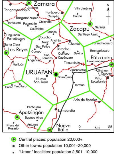
Central place theory may work quite well in Mexico in terms of the relative numbers of settlements of different size, but the theory also suggests that those places on the same level of the urban hierarchy should form a distinctive spatial pattern and be roughly equidistant from one another. In essence, this means that each of these central places will be at the center of an approximately equally sized market area, or sphere of influence, well positioned to serve everyone who lives within its limits.

The application of central place theory to Uruapan, Michoacán

The application of central place theory to Uruapan, Michoacán. Credit: Tony Burton / Geo-Mexico; all rights reserved

The map shows the settlements in the western part of the state of Michoacán. The largest city by far is Uruapan (250,000 inhabitants in 2008). Around Uruapan are six fairly large neighboring towns or cities. Each of these settlements has its own corresponding market area. However, even though these six places are roughly equidistant from Uruapan, they turn out to be very different in size. For example, Zamora (240,000) has more than four times the population of Pátzcuaro (53,000). Zamora is bigger because in addition to providing services to a larger, more prosperous, surrounding market area, it also has some manufacturing and is on a railroad line and the original highway between Mexico City and Guadalajara.

In addition, there is no observable regularity in the pattern of settlements of the two smaller sizes—“other towns” and “urban localities”—shown on the map. This is clearly in contradiction to central place theory, but should not really be a surprise. The theory assumes, for the sake of simplicity, that large areas will not have any significant differences in relief or soil fertility and that transport costs will be directly proportional to distance. It also assumes that rural areas have equal population densities and that their residents have similar consumer tastes and purchasing power. In practice, these assumptions are not valid, and some of the anomalies in the pattern of settlements shown on the map can be easily explained. For instance, the areas immediately north of Apatzingán and east of Nueva Italia are very mountainous, far less favorable for farming and settlement than the area north of Uruapan.

The very idea that settlements will be equidistant from one another begs a very important question, pertinent to our earlier discussion of the categories of rural settlements. Should we measure distance only in a spatial sense, in kilometers, or might it be more worthwhile to consider it in terms of the time or monetary cost required to make a particular journey, taking into account the terrain and transportation network?

In summary, central place theory does a good job of explaining the number of central places at each level and the types of services they provide. At the same time, departures from the idealized shape and size of market areas predicted by the theory help to reveal the complexities of Mexico’s physical, human and socio-economic geography.

Related posts:

The hierarchy of central places in Mexico

 Excerpts from Geo-Mexico  Comments Off on The hierarchy of central places in Mexico
Jul 132011
 

How well does central place theory fit the Mexican situation? In terms of the relative numbers of settlements of different size, it fits quite well. The theory suggests that there will be a regular (geometric) progression between the number of settlements of each successive size. The hierarchy of central places in Mexico is quite similar to that predicted by the theory (see table).

Population sizeNumber of localities or municipalities% of national population
< 2,500184,71423.5
2,500–9,9992,37910.6
10,000–49,99961512.1
50,000–499,99916225.6
500,000–999,9992313.9
1,000,000 +1114.3

At the lowest level in Mexico are a large number of very small centers providing a limited range of goods and services. At this level are small convenience stores (abarrotes or bodegas) selling basic Mexican household goods such as sugar, tortillas, bread, produce, snacks, basic canned goods, candy, eggs, beer, soft drinks, cigarettes, matches and basic toiletries.

Other small stores at this lowest level might sell such things as household cooking and lighting fuels (wood, gas, or kerosene), seed, animal feed, fertilizer and other basic farm inputs. Other services might include a place that buys agricultural production, auto and tire repair shops, and a bus pick-up point. Some of these small centers might also have tortillerías (shops making tortillas), a primary school and a pay phone.

At the next higher level there is enough demand to support everything at the lowest level plus simple bakeries, hardware stores, mini-super markets, electrician/plumbers, welding shops, simple clothiers or dressmakers, beauty salons, basic health care, simple pharmacies, a church, a secondary school, simple eateries, and repair of household electrical items (radios, blenders, TVs). There might be only half or a third as many settlements (places) at this level as at the lowest level.

Central places at this level might also have weekly or periodic markets. Such markets usually occur only one day a week because there is not sufficient threshold demand to support them on a daily basis.

The link is to a map showing the major weekly marketing cycles for the Oaxaca area in southern Mexico. With the exception of Oaxaca city (population 480,000) and Miahuatlán (33,000), all the other towns have populations between 13,000 and 20,000. The merchants at such markets generally carry their wares from village to village on the days of their respective markets. Some local farmers also sell their produce at such markets. These markets give villagers access to a much wider range of goods than might otherwise be possible. Simultaneously, traders maximize their opportunities to make a profit.

Depending on the rural population density and economic demand for particular goods and services in the geographic area, periodic or weekly markets may not exist at this level of the hierarchy in some regions and may only appear at higher levels.

A similar principle applies to a circus (figure 24.4 in Geo-Mexico), which needs access to an even larger threshold population than a weekly market. This is because each individual visitor will not be prepared to travel far to see the show and has little interest in seeing the same acts more than once. Even a very large city will only house enough people to fill the Big Top for a few weeks. The circus’s solution, in central place terms, is to access the combined populations of numerous towns or cities by moving from one to the next, on an annual or biannual itinerary.

As we move up the hierarchy in Mexico, there is enough demand to support everything at the lower levels as well as new services requiring higher levels of threshold demand. These might include doctors, dentists, carpenters, construction supplies, furniture and cabinet makers, bars, restaurants, a Pemex gas station, auto parts stores, and a variety of retail outlets selling such things as stationary and paper products, mobile phones, toys, flowers, plastic ware, and kitchen items. Centers at this level are larger and far fewer in number than the smaller centers at lower levels.

At the next higher level there are even fewer and even larger central places providing such services as appliance sales, jewelry stores, banks, opticians, lawyers, accountants, photographers, preparatory schools, hospitals, hotels, used car and pickup sales, a Coca-Cola bottler, funeral homes, a bus station, a Telmex office, TV and electronics sales, cyber cafes, clothing boutiques and shoe stores.

Further up Mexico’s hierarchy there is enough demand to support higher level services such as: new car and truck sales, TV and radio stations, movie theaters, giant supermarkets, printers, bookstores, dry cleaning, real estate offices and office supply stores. Centers at this level would be fewer in number and have larger geographic market areas.

At the top of the hierarchy are places like Mexico City and Guadalajara, where the demand is sufficient to support the highest level goods and services such as giant modern retail malls, international airlines, convention centers, international hotels, live theater, investment banking, TV studios, multimedia advertising agencies, major universities with medical schools, all types of specialized luxury products, and very specialized professional services such as heart and brain surgeons.

Related posts:


The four basic types of rural locality in Mexico

 Excerpts from Geo-Mexico  Comments Off on The four basic types of rural locality in Mexico
Jul 062011
 

In a previous post, we looked at why Some rural areas are more rural than others.This post describes each of the four distinct categories of rural areas identified by Mexico’s National Population Council (CONAPO).

Rural localities near cities

This group is defined as localities within five kilometers (3 mi) of cities of at least 15,000 inhabitants. It accounts for 16% of Mexico’s rural population, about four million people. About half of the rural populations of Morelos and Tlaxcala fall into this group.

Some communities in this category are actually part of the suburbanization or urban sprawl process. People have ready access to many city services and opportunities. If they lack mechanical transportation, they can walk to the city in less than an hour.

What are the socioeconomic characteristics of these localities? The data needed to answer this question often are not readily available. Fortunately, CONAPO has classified rural localities in terms of their degree of marginalization, which provides insights into socioeconomic characteristics. Degree of marginalization is defined using indicators of adult educational attainment, housing quality, and income levels.

About 47% of rural, near city residents live in very marginalized localities.3 While this is much higher than it is in urban areas, it is significantly less than other rural areas. Rural areas near cities tend to be more similar to urban areas. By way of comparison, in Mexico as a whole about 19% of the population live in municipalities classified as very marginalized.

Representative characteristics of very marginalized communities include adult populations with illiteracy rates of about 25% and completion of primary school rates of only 56%. Roughly 27% of houses lack piped water, 27% lack indoor toilets, 46% have dirt floors and 64% are overcrowded. These housing indicators are closely correlated with significant health risks. About 15% of houses do not have electricity. Roughly 84% of economically active people make less than twice the minimum wage. Communities matching this description are very different from modern urban Mexico.

At the other end of the spectrum, only about 4% of near city residents live in non-marginalized localities, which we will call “modern”.5 For Mexico as a whole, 53% of the population live in modern municipalities. The figure is 100% for the 33 million people who live in Mexico’s nine urban areas of over one million inhabitants. Levels of marginalization will be discussed more fully in chapter 29.

Rural localities near towns

This category includes localities within three kilometers of towns with between 2,500 and 15,000 residents. About 2.4 million people, or 10% of the rural population, live in such communities. These localities account for about a quarter of the rural population of Morelos and the State of Mexico.

Communities in this category are more rural than communities near cities. They have easy access to goods and opportunities in towns, but lack ready access to a real urban area. About 66% of this group lives in very marginalized communities compared to 47% for the near cities group. Less than 1% of the near towns group live in modern communities.

Rural localities near roads

This large group includes localities within three kilometers (2 mi) of paved roads. Almost 13 million Mexicans, about 54% of the rural population, fall into this category. It accounts for almost 90% of the rural population in Quintana Roo and over 70% in Zacatecas, Yucatán, Campeche, San Luis Potosí, Nuevo León and Coahuila.

This is a relatively important category because almost 14% of Mexico’s total population lives in rural communities near roads. These localities account for 39% of the total population of Zacatecas, and about a third of the total for Hidalgo, Oaxaca and San Luis Potosí. The authors agree to differ as to the reasons for this. One of us believes that the location of paved roads is having an impact on rural settlement patterns. The other believes that rural settlement patterns are having an impact on the location of paved roads! Both viewpoints may be correct with their relative importance depending on the region in question.

While people living in these localities do not have walking access to a city or town, they can relatively easily get to a town or city by bus. Some 69% live in very marginalized communities, while less than 1% live in modern communities. In terms of marginalization, the near roads group is quite similar to the near towns group.

Isolated rural localities

This group includes rural localities that do not fit into any of the other three categories. They are the most rural in that they lack ready access to paved roads, towns or cities. These inaccessible areas are very rarely seen by outsiders. Most urban residents have limited understanding of life in these isolated areas. Communities in this group are among Mexico’s poorest. About 88% of the people in isolated rural localities live in communities classified as very marginalized; less than 1% live in modern communities.

Though data are not available, areas that are within 10 km of a city, town or paved road are likely to be less marginalized than those in more remote locations. Almost five million Mexicans, about 20% of the rural population, live in these communities. Over a million people in Chiapas and about half a million in Oaxaca and Puebla live in isolated localities. The figure for Chiapas represents 29% of the state’s total population. About 16% of the people in Nayarit and Oaxaca and 12% of those in Sinaloa and Guerrero live in isolated areas. Providing needed basic services to these rural Mexicans is a major challenge for these state governments as well as the federal government.

Related posts:

Are Mexico’s rural areas more diverse than its cities?

 Excerpts from Geo-Mexico  Comments Off on Are Mexico’s rural areas more diverse than its cities?
Jun 302011
 

Which are more diverse: Mexico’s rural areas, or its cities?

At first glance, Mexico’s rural areas are all quite similar in that they lack the characteristics of Mexico’s large cities such as tall buildings, traffic congestion, modern shopping malls, bustling streets, heavy industry and the like. While rural areas are all similar in that they lack urban characteristics, Mexico’s rural areas are actually quite diverse. But is there really more diversity among Mexico’s rural communities than its cities?

The physical form and architecture of cities are essentially independent from their surrounding natural environments. On the other hand, rural settlements tend to be integrated more closely with the natural environment. For example, villages in the arid central plateau tend to be constructed of locally available adobe, which keeps residents relatively cool during the hot afternoons and warm during the colder nights. In the tropical parts of Mexico, rural settlements tend to be built with locally available tropical materials which keep the rain out, but let air breezes through to mediate the hot tropical climate.

Rural settlements all tend to rely heavily on farming as the basic economic activity. The surrounding natural environment essentially dictates the type of farming that is practiced. Obviously, farmers in the central plateau cannot successfully grow bananas, sugarcane and other tropical products requiring lots of water. However, varieties of corn are grown virtually everywhere in Mexico.

The social characteristics of Mexico’s rural areas are also very diverse compared to the cities. In general Mexican cities are quite similar from a social perspective. Social customs and mores, as well as social classes, are relatively constant from one city to the next. Spanish is the overwhelmingly dominant language in the cities. Rural communities in various parts of the country often have different social mores and customs. Communication in some rural areas is largely, if not almost exclusively, in local indigenous languages:

The diversity of Mexico’s almost 200,000 rural localities should not be confused with the relative homogeneity within any given rural community.

In conclusion, while diversity between rural areas may be greater than that between cities, there is usually far more diversity within a Mexican city than within any given rural community.

Apr 302011
 

The quality of housing in Mexico has improved significantly in the past two decades. By the 2010 census, 97.8% of Mexican households had access to electricity, compared to 95.0% in 2000 and 87.5% in 1990. That this figure is approaching 100% is a real accomplishment given that many Mexicans live in very isolated mountainous communities. As of mid-2010, 93.5% of rural households had electricity, compared 98.2% for towns between 2,500 and 15,000 and over 99% for larger towns and cities. Anyone who has lived without electricity knows what an incredible improvement it can make to one’s comfort and quality of life.

With smaller family sizes, household crowding has also declined. It went from 5.0 persons per household in 1990 to 4.4 in 2000 and 3.9 in 2010. The percentage of households with dirt floors is now down to 6.2%, compared to 13.2% in 2000 and 19.5% in 1990. In rural areas, 15.1% of houses have dirt floors compared to 7.7% in towns between 2,500 and 15,000.

The vast majority of rural houses now have piped water. In the 125 least developed municipalities in rural Mexico, over 63% of households have piped water, which is one of the most important factors for improved family health. Almost 39% of the households in these poor municipalities have sewers, a convenience that most rural residents now have. However, about half of all rural households still cook with firewood or charcoal.

Rural households are gaining increasing access to modern electrical conveniences. Almost 80% now have a television set, 62% have a refrigerator, 42% have a washing machine, and 36% have a cell phone (only 17 % have a wired telephone line). While these percentages are significantly higher in urban areas (TVs – 97.5%, refrigerators – 91.7%, washing machines – 78.4%, and cell phones – 78.4%.), life in rural Mexico is improving dramatically. However, rural areas are lagging significantly in access to the cyber-age. Only 6.8% have a computer in the house and 2.5% have internet access. Urban access is much higher: 42.7% for home computers and 33.1% for internet access. On the other hand, many rural households gain access to computers and the internet by using cyber-cafes, which have spread rapidly into small Mexican communities.

Local "bus" to the train station, Tehuantepec, 1985

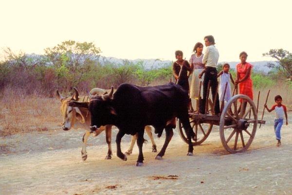
Local "taxi" to the train station, Tehuantepec, Oaxaca, 1985. Photo: Tony Burton; all rights reserved

Access to public transportation has also improved in rural areas (see photo, taken in 1985). In mid-2010, 73% of rural residents had access to public transportation (usually bus or taxi). Access varies with community size. Of those in communities of 1,000 to 2,500, almost 90% have access, while only 37% of those localities of under 250 population had access to public transportation.


Mexico’s cities and towns are analyzed in chapters 21, 22 and 23 of Geo-Mexico: the geography and dynamics of modern Mexico. Rural Mexico is the subject of chapter 24. Living standards, including housing, are discussed in chapter 28. Buy your copy today!!

Review of “One Hundred and One Beautiful Small Towns in Mexico”.

 Books and resources  Comments Off on Review of “One Hundred and One Beautiful Small Towns in Mexico”.
Jul 302010
 

In an earlier post, we listed the towns included in One Hundred and One Beautiful Small Towns in Mexico, by Guillermo García Oropeza and Cristóbal García Sánchez (Rizzoli International Publications, 2008; 280 pp.). Here we offer a short review of the book.

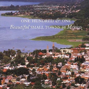
Cover of 101 Beautiful Small Towns in MexicoThis is a large format book, with many magnificent photographs. A fascinating range of places is included, even though the criteria used for their selection are nowhere explained. The selection offers lots of interest for anyone curious about Mexico’s geography.

For example, a stunning aerial view of Mexcaltitán (Nayarit) shows the cross-and-concentric-circle street pattern of “Mexico’s Venice”, surrounded by muddy brown shrimp-bearing swamps.

Curiously, the list of places included in the book on the contents pages adopts the affected style of using no capital letters whatsoever for any of the town names.

Each place is afforded at least a double page spread, and the back of the book has helpful lists of tourist offices, and selected hotels and restaurants.

Despite the title, some of the locations are more to do with the natural environment than with settlement. For instance, the town of Cuatro Ciénegas is a somewhat unprepossessing place whereas the desert oases of Cuatro Ciénegas,on which the book entry focuses, are an amazing natural zoological laboratory of crystalline water and extraordinary biodiversity. Similarly, Cacahuamilpa Caverns hardly qualify as a town!

The San Ignacio entry focuses on difficult to reach cave paintings. The village itself has few claims to fame beyond its colonial mission church.

The Paricutín double-page spread is named after the volcano which devoured several small settlements including Parícutin (for the name of the original village, the accent is on the second syllable; for the volcano it is on the last syllable). The photos included here actually show (as the captions make clear) the towns of Angahuan, and the upper facade of the church of San Juan Parangaricutiro, overwhelmed by the volcano’s lava.

A couple of places are given names that might not be very familiar to their residents. Casas Nuevas (Chihuahua) is actually Nuevo Casas Grandes (the real Casas Nuevas is an entirely different place which had only 13 inhabitants at the time of the 2000 census) and Mineral del Monte (Hidalgo) is more usually known as Real del Monte.

In southern Mexico, Santa María del Tule gets an entry. Santa María would not be worthy of mention, except for the fact that it is home to what is arguably the world’s largest tree, now thankfully restored to good health after decades of neglect.

In the Yucatán, three entries ignore the main thrust of the book, and focus instead on significant routes, one linking henequen (sisal) haciendas, one combining relatively minor archaeological sites which share distinctive Puuc architecture, and one going from one friary (monastery) to another. These are all interesting trips, but are entirely unexpected in a book specifically about towns. Some judicious editing might have removed some of the inaccuracies such as describing hemp (sisal) as “in the agave… or cactus, family”. The family name for agaves is Agavaceae which includes the genus Agave. In any event, agaves are biologically distinct to all members of the Cactaceae family; confusing agaves with cacti is an unexpected blunder.

The chosen towns quite rightly include some long-abandoned sites such as Teotihuacan, “City of the Gods”, which was once a city of 200,000 or so, the fascinating Mayan sites of Palenque and Chichen Itza, and Mitla and Monte Alban, both in Oaxaca.

The cover photo of the town of Chapala in Jalisco, much favored by American and Canadian retirees in recent years, unfortunately dates from a time when the lake level was relatively low. The green areas in the lake are floating masses of the introduced aquatic weed water hyacinth.

Despite being written by a Mexican historian, there are numerous minor historical inaccuracies in the text, though these should not detract from the enjoyment of the average reader.

For instance, in the Chapala entry, illustrated by the same photo used on the cover, it should be Septimus Crowe (not Crow), and the “navigation company with two small steam ships” had nothing to do with Christian Schjetnam. The steamships predated his arrival in Chapala by many years. Schjetnam did however, introduce two small sail yachts to the area, perhaps explaining the confusion. The description of President Díaz’s interest in Chapala appears to imply that he was first acquainted with the lake when he visited “a political crony” in 1904. Actually, Díaz was certainly personally familiar with Lake Chapala from long before this.

The entry for Santa Rosalia repeats the long-held but unproven idea that the main church was designed by Frenchman Gustave Eiffel (of Eiffel Tower fame). The town does have other Eiffel connections, and the church may indeed have been brought lock, stock and barrel from the 1889 Paris World Exhibition. However, research by Angela Gardner strongly suggests that the original designer was probably not Eiffel but was far more likely to have been Brazilian Bibiano Duclos, who graduated from the same Parisian academy as Eiffel. Gardner proved that Duclos took out a patent on prefabricated buildings, whereas she could find no evidence that Eiffel had ever designed a prefabricated building of any kind. Regardless of who designed it, it is certainly a unique design in the context of Mexico, and well worth seeing.

And really, surely this is the main point of this book. It was presumably never intended to be a reliable geographical (or historical) primer, but rather an enticing selection of seductive places, many of which will be unfamiliar to any but the most traveled reader. The variety of places included is breathtaking; few countries on earth can possibly match it. As such, One Hundred and One Beautiful Small Towns in Mexico is a resounding success.

This beautifully illustrated book should certainly tempt readers to venture into new parts of Mexico in search of these and other memorable places. Enjoy your travels!

– – – –

Mexico’s cities and towns are analyzed in chapters 21, 22 and 23 of Geo-Mexico: the geography and dynamics of modern Mexico. Buy your copy today!!

Jul 242010
 

According to the book One Hundred and One Beautiful Small Towns in Mexico, by Guillermo García Oropeza and Cristóbal García Sánchez (Rizzoli International Publications, 2008; 280 pp), these places all merit inclusion in the list of the 101 Beautiful Small Towns in Mexico.

Cover of 101 Beautiful Small Towns in MexicoWe will review the book more formally in a future post, since it offers some insights into Mexico’s geography, but for now take a look at the list below, and see if you agree.

Our own list of the most beautiful small towns would certainly include most of these, though we can think of some equally excellent choices which are not included.

Are there other towns that would be on your list? If so, let’s hear about them!

BAJA CALIFORNIA

  • San Felipe
  • Valle de Guadalupe

BAJA CALIFORNIA SUR

  • Loreto
  • Mulegé
  • San Ignacio
  • San Jóse del Cabo
  • Santa Rosalía
  • Todos Santos

CAMPECHE

  • Campeche
  • Edzná

CHIAPAS

  • Comitlán de Domínguez
  • Chiapa de Corzo
  • Palenque
  • San Cristóbal de las Casas
  • Yaxchilán
  • Bonampak
  • Zinacantán
  • San Juan Chamula

CHIHUAHUA

  • Batopilas
  • Creel
  • Hidalgo del Parral
  • Nuevas Casas [Nuevo Casaas Grandes]
  • Mata Ortíz
  • Cuarenta Casas

COAHUILA

  • Cuatro Ciénegas
  • Parras

COLIMA

  • Cómala

FEDERAL DISTRICT

  • Coyoacán

GUANAJUATO

  • Atotonilco
  • Dolores Hidalgo
  • Guanajuato
  • San Miguel De Allende
  • Yuriria

GUERRERO

  • Cacahuamilpa
  • Taxco

HIDALGO

  • El Chico
  • Huasca
  • Mineral del Monte [Real del Monte]
  • Tula

JALISCO

  • Chapala
  • Ajijic
  • Lagos de Moreno
  • Mazamitla
  • Puerto Vallaría
  • San Sebastián del Oeste
  • Tapalpa
  • Tequila
  • Tlaquepaque

MEXICO STATE

  • Malinalco
  • Teotihuacán
  • Acolman
  • Tepotzotlán
  • Valle De Bravo

MICHOACÁN

  • Angangueo
  • Cuitzeo
  • Paricutín
  • Angahuan
  • Santiago Nurío
  • Paracho
  • Pátzcuaro
  • Santa Clara del Cobre
  • Zirahuén
  • Tlalpujahua
  • Tzintzuntzan

MORELOS

  • Cuernavaca
  • Tepoztlán
  • Tétela del Volcán
  • Xochicalco
  • Yecapixtia

NAYARIT

  • Mexcaltitán

NUEVO LEÓN

  • Bustamante
  • Villa de García

OAXACA

  • Cuilapan
  • Arrasóla
  • Ixtlán De Juárez
  • Mitla
  • Monte Albán
  • Ocotlán
  • San Bartólo Coyotepec
  • Santa María del Tule
  • Tlacochahauya
  • Tlacolula
  • Dianzú
  • Yanhuitlán

PUEBLA

  • Cuetzalan
  • Cholula
  • Huejotzingo
  • Tonantzintia
  • San Francisco Acatepec

QUERÉTARO

  • Bernal
  • Jalpan

QUINTANA ROO

  • Bacalar
  • Cozumel
  • Holbox
  • Isla Mujeres
  • Playa del Carmen
  • Tulum

SAN LUIS POTOSÍ

  • Real de Catorce

SINALOA

  • Cósala

SONORA

  • Alamos
  • Magdalena de Kino

TLAXCALA

  • Tlaxcala

YUCATAN

  • Chichen Itza
  • Izamal
  • Uxmal
  • Valladolid

VERACRUZ

  • Coatepec
  • Los Tuxtlas
  • Papantia
  • Tlacotalpan

ZACATECAS

  • Guadalupe
  • Jerez
  • Sombrerete

Mexico’s cities and towns are analyzed in chapters 21, 22 and 23 of Geo-Mexico: the geography and dynamics of modern Mexico. Buy your copy today!!

Jul 232010
 

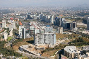
Santa Fe, in upscale western Mexico City is one example of the many new developments being built on the urban periphery in Mexico.

Santa Fe, a subsidiary CBD in Mexico City

Santa Fe has become a subsidiary CBD in Mexico City. Photo: Oscar Ruiz

The plan for the Santa Fe complex called for private sector financed office towers, a gigantic retail mall, high income housing, park areas, as well as schools and universities. Construction was halted briefly by the 1994–95 economic crises, but soon resumed at full speed. Today Santa Fe has numerous skyscraping office towers, over one eighth of the Federal District’s total office space, about 70,000 employees, four universities with 13,500 students, over 4300 residents, and one of the largest retail malls in Latin America.

Santa Fe is essentially an island that is only accessible by private car; public transport is relatively limited.

Unfortunately, it has not fully lived up to expectations. The preponderance of cars, mostly with a driver and no passengers, has led to severe traffic jams. Perhaps related to this, the vacancy rate of office space is about 25%. Furthermore, even with eight million visitors a year, the gigantic Santa Fe shopping mall is not as heavily utilized as competing malls in the area.

How many of the shoppers in Santa Fe mall or students attending classes realize that they are on top of what was once one of the biggest garbage dumps in Mexico City? Prior to its development into high-end real estate, much of this area had been quarried for sand, and the resulting holes  used as a landfill site for household and industrial waste. Some of the structural problems reported in buildings in Santa Fe may well be due to the settling of these less than savory foundations.

(Our sincere thanks to Fatimah Araneta for improving this account)

If you have enjoyed this brief excerpt from chapter 23  of Geo-Mexico: the geography and dynamics of modern Mexico please consider purchasing your own copy of the book. Chapters 21 and 22 analyze Mexico’s 500-year transition to an urban society and the internal geography of Mexico’s cities. Chapter 23 looks at urban issues, problems and trends. To preview more parts of the book, click here and use amazon’s “Look Inside” feature.

A case study of low-income housing on the urban periphery

 Excerpts from Geo-Mexico  Comments Off on A case study of low-income housing on the urban periphery
Jul 132010
 

A shortage of affordable housing is a persistent problem in large Mexican cities. In response, new, subsidized lower income housing developments are being built on the periphery of Mexico City, Guadalajara, Monterrey, and other metropolitan areas.

Sprawling Mexico City - "El Monstruo"

Sprawling Mexico City - "El Monstruo"

Though most working families can afford the down payment and monthly payments for these subsidized housing units, these expenses leave little extra for food, clothing, utility bills, commuting, and health care. Even these subsidized housing units provide a car parking place because virtually all Mexican families aspire to own their own automobile. The case study which follows, of the Hernández family, illustrates the situation.

Carlos Hernández, his spouse, mother-in-law, and two daughters are happy with their house in a new housing development in Zumpango, about 40 km (25 mi) north of the Mexico City Zócalo. The government-backed mortgage on the tiny (30 square meters – 323 square feet, about the size of a two-car garage), 15,700-dollar, one-bedroom house, is 100 dollars a month. Hernández must spend another $110 a month for his daily five hour commute by colectivo (mini bus), bus, and metro (subway) to his $350 a month maintenance job in the capital. This leaves only $140 a month for all other expenses such as food, utilities, installment payments on furniture and appliances, health care, clothing, schooling, etc. To help make ends meet, his spouse, Edith, runs an informal convenience store out of the front of the house.

The house is very crowded; the kitchen table is brought inside only at mealtimes. Carlos and Edith sleep on a foldout couch in the living room. Edith’s mother, Lucía, has the bedroom and the two daughters take turns sleeping with their parents or grandmother. Hernandez is glad he finally owns a house and no longer has to pay rent. His story is repeated tens of thousands of times as hundreds and hundreds of low-income housing developments are being built on the urban periphery.

If you have enjoyed this brief excerpt from chapter 23  of Geo-Mexico: the geography and dynamics of modern Mexico please consider purchasing your own copy of the book. Chapters 21 and 22 analyze Mexico’s 500-year transition to an urban society and the internal geography of Mexico’s cities. Chapter 23 looks at urban issues, problems and trends. To preview more parts of the book, click here and use amazon’s “Look Inside” feature.

Nezahualcoyotl, an irregular settlement which grew into a monster

 Excerpts from Geo-Mexico, Updates to Geo-Mexico  Comments Off on Nezahualcoyotl, an irregular settlement which grew into a monster
Jul 022010
 

Rapid industrialization north of Mexico City after World War II brought a giant wave of immigrants aggravating a serious shortage of low income housing. With the vecindades (inner city slums) severely overcrowded, the only alternative was “irregular housing” or “colonias populares.” These were developed wherever there was vacant land, mostly in the west and north of the city on the dry former lakebed or on very steep slopes. They all followed a development pattern roughly similar to that of Nezahualcoyotl, the largest and best known colonia popular.

The densely packed housing of Nezahaulcoyotl in all its glory

The densely packed housing of Nezahaulcoyotl in all its glory. Image: imagenesaereasdemexico.com. Follow link at end of post for more Mexico City photos

In the late 1950s, a group of speculators gained de facto possession of roughly 78 square kilometers  (30 square miles) of former lakebed in Nezahualcoyotl just east of the Mexico City airport. They sold nearly 200,000 plots cheaply and on credit, a few dollars down, and a few dollars a month, for 10-20 yrs.

Families bought plots and immediately started to erect shacks. Aside from electricity, which was provided by the national utility, the plots initially lacked basic services such as potable water, sewerage, flood drainage, pavement, schools, etc. Without services, Nezahualcoyotl was illegal under State of Mexico law; but the government tolerated this situation.

The community became an immediate boom town. By 1970, the population was over 600,000, but still over half the area was without paved streets, water supply and drainage. Summer brought floods while the rest of the year it was an arid dust bowl.

Residents became frustrated with the broken promises of the developers, demanded that they be jailed for fraud, and stopped their monthly payments. The feud lasted for years and some developers were actually jailed. Eventually most of the area was “regularized”, meaning that residents got legal deeds and basic services. They continued to improve their houses and communities.

Nezahualcoyotl, the city of dreams

Nezahualcoyotl, the city of dreams

By 1980, the population reached about 1.3 million, making it one of the largest and most densely populated municipalities in the country.

By 2000, Nezahualcoyotl had essentially joined the mainstream. Nearly all residents had electricity and TVs, over 80% had refrigerators, 60% had telephones, nearly one in three had access to an automobile, and almost one in five had a computer. While Nezahualcoyotl has slums, gangs and crime, it also has tree-lined boulevards, parks, a zoo, banks, shopping centers, offices, libraries, hospitals, universities, cinemas, and apartment buildings. It even has a cathedral (since 2000) and an Olympic sports stadium, which hosted some 1986 FIFA World Cup matches. Currently, it is a vital part of metropolitan Mexico City and provides jobs for almost 250,000.

From irregular settlement to massive urban monster; Cd. Nezahualcoyotl has certainly come a long way!

Mexico’s cities and towns are analyzed in chapters 21, 22 and 23 of Geo-Mexico: the geography and dynamics of modern Mexico. Buy your copy today!!

Los Mochis and Topolobampo are two examples of “new towns” in Mexico

 Other  Comments Off on Los Mochis and Topolobampo are two examples of “new towns” in Mexico
Apr 262010
 

In north-western Mexico, two towns in close proximity—Los Mochis and Topolobampo—are both examples of “new towns”. Many Mexican towns and cities are more than 500 years old; relatively few major settlements in the country are less than 150 years old. How did it come about then that these two “new towns” in the state of Sinaloa were founded so close to one another?

Topolobampo dates back only as far as 1872, when a US engineer, Albert Kimsey Owen (1847-1916) arrived. Owen envisaged the city as a U.S. colony centered on sugar-cane production in this previously unsettled area and as the terminus for a railway across the Sierra Madre Occidental.

Owen had been raised in New Harmony, the city founded by Robert Owen (no relation) and decided to try and found a similar “ideal socialist” city somewhere in Mexico. In 1871-1872 he visited Chihuahua and Sinaloa and decided that the site of present day Topolobampo was ideal for his purposes. Owen founded the Texas, Topolobampo and Pacific Railroad and Telegraph Company (later the American and Mexican Pacific Railroad) and in 1881 was granted the concession for the settlement of a town.

Settlement began in October 1886. Two and a half years later, in April 1889, the first large group of colonists—300-strong—set sail from New York, arriving in Sinaloa in July, only to find a deserted beach and no Owen. Owen had returned to the USA but finally arrived the following year with another 30 colonists. During 1891, 70 more settlers arrived. They founded several additional settlements including Vegatown (Estación Vega), La Logia, El Público and El Platt. They also dug an irrigation canal, 12 kilometers long, to divert water from the Fuerte River across their lands. Despite their heroic efforts, the farming project was eventually abandoned, though the town of Topolobampo struggled on.

The Henry Madden Library of the California State University, Fresno, houses an amazing visual record of those early years, based on photos dating back to 1889-90 taken by Ira Kneeland, one of the first settlers.

Meanwhile, in 1893, another American, Benjamin Francis Johnston (1865-1937) founded the Eagle Sugar Co. (Compañia Azucarera Aguila S.A.) and constructed a factory, church, airport, dam, and the Memory Hill lighthouse. Ten years later, in 1903, Johnston officially founded Los Mochis. Johnston came to own more than 200,000 hectares. He built a veritable palace of a residence, including an indoor pool and even an elevator, one of the first in the country. The mansion’s garden, full of exotic plants, is now the city’s botanical gardens, Parque Sinaloa. The mansion itself was later torn down for a shopping plaza.

Historians and geographers have long questioned the precise motives of both Owen and Johnston, whose efforts have been described as more akin to capitalist expansion and neo-imperialism than any form of socialism. If they had come to fruition, Owen’s projects could have resulted in the annexation of a million square kilometers to a USA which had ambitious ideas of expansion at the time. Owen has been labeled variously a visionary, a madman or a conman and fraudster. Similarly, Johnston has also been regarded by some as a stooge for grandiose US expansionist plans.

Whatever the motives of their founders, both Topolobampo and Los Mochis had their start and have rarely looked back. Los Mochis gained importance as a major commercial center, marketing much of the produce grown on the enormous El Fuerte irrigation scheme. A large proportion of this produce is exported to the U.S. via the famous Copper Canyon railway. Los Mochis is the passenger terminus at the western end of the  line. For freight, the line continues to Topolobampo, “the lion’s watering place” or “tiger’s water”. The port, with its shrimp-packing plant, is at the head of one of Mexico’s finest natural harbors, the head of a drowned river valley or ria, which affords an unusually high degree of security in the event of hurricanes.

This is an edited version of an article originally published on MexConnect. Click here for the original article

Urban settlements in Mexico are discussed in chapters 21 and 22 of Geo-Mexico: the geography and dynamics of modern Mexico, with urban issues being the focus of chapter 23.