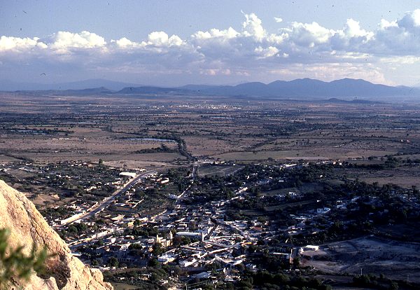
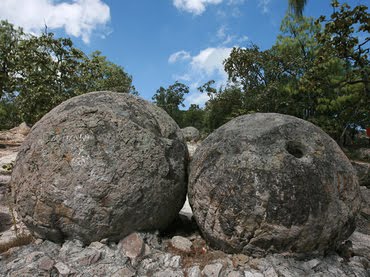
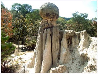
Basalt columns and prisms can be seen in various places in Mexico

 Other  Comments Off on Basalt columns and prisms can be seen in various places in Mexico
Oct 252016
 

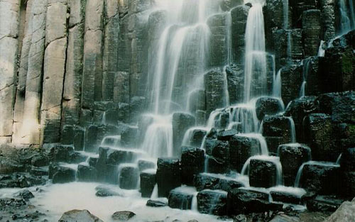
Basalt is a dark, fine-grained, basic (low silica) igneous rock, often extruded as molten lava from volcanic fissures. Its low silica content means it can flow easily, often building up over the years to form large plateaus. As the basaltic lava cools, it contracts and solidifies. An extensive network of cracks often develop in basalt, which may extend many meters deep. These cracks tend to leave columns between them which are roughly hexagonal (6-sided) in shape. Among the more famous examples of basalt columns or pavements in the world are Giant’s Causeway (Northern Ireland), Fingal’s Cave (Scotland) and Devil’s Postpile (California, USA).

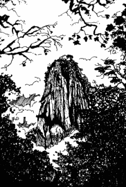
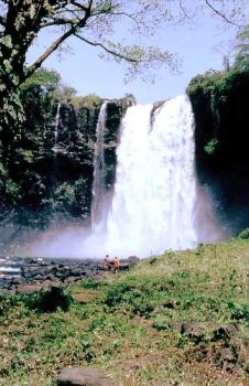
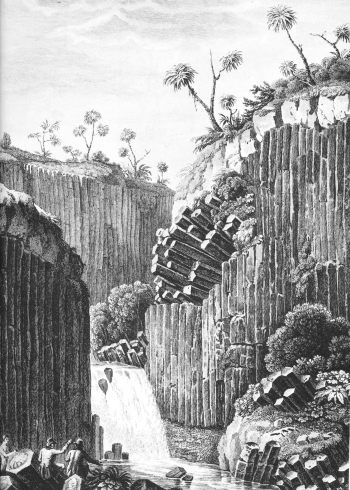
The best known location in Mexico to see basalt columns is about an hour’s drive north of Mexico City, at Santa María Regla, in the state of Hidalgo. These columns, attractively located on the side of a canyon, with a waterfall tumbling over some of them (see sketch), were visited by the famous Prussian scientist/geographer Alexander von Humboldt, during his exploration of Mexico in 1803-04. Some individual columns are 40 meters tall.

Basalt prisms at San Miguel Regla

Basalt prisms at San Miguel Regla, from Humboldt and Bonpland, Vues des Cordilleres et monumens des peuples indigenes de l’Amerique.

The basalt columns of Santa María Regla are one of the locations described in The first geography fieldtrip guide in Mexico. They are also one of Mexico’s top 13 natural wonders.

Basalt prisms at Santa María Regla

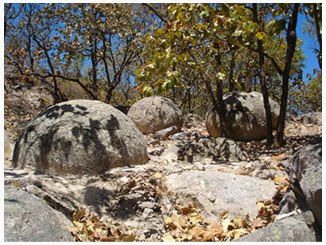
Other locations in Mexico where basalt columns or prisms can be seen include a quarry between the towns of Jamay and Ocotlán (Jalisco), the south-facing slope of the hills overlooking the town of Chapala (Jalisco) and the Salto (waterfall) de San Antón (Cuernavaca, Morelos).

Mexico’s geology and landforms are analyzed in chapters 2 and 3 of Geo-Mexico: the geography and dynamics of modern Mexico.  Buy your copy of this book today!

The deepest water-filled sinkhole in the world is in Tamaulipas, Mexico

 Other  Comments Off on The deepest water-filled sinkhole in the world is in Tamaulipas, Mexico
Oct 122016
 

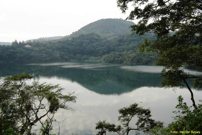
As vertical shafts go, this is a seriously deep one! Long considered to be “bottomless” (because no-one had ever managed to find the floor), we now know it is precisely 335 meters (1099 feet) deep, making it the deepest water-filled sinkhole anywhere on the planet.

The El Zacatón sinkhole is on El Rancho Azufrosa, near the town of Aldama in Tamaulipas in northeast Mexico. The sinkhole or cenote is one of several located in the same area, though recent studies have failed to demonstrate any obvious underground connections between them. The term cenote is a Spanish rendering of the Mayan word d’zonot, “a hole in the ground”. The El Zacatón pit, which is about 110 meters (360 feet) across and roughly circular, contains a deep lake. The water is warm (averaging about 30 degrees C), highly mineralized and has a sulfurous odor. The name El Zacatón comes from the floating islands of grass (zacate) which blow across this lake from one side to the other with the wind.

The pit’s depth has attracted serious divers for many years. In 1993, Dr. Ann Kristovich dove to a new women’s world record depth of 169 meters (554 feet). The following year, two American explorers tried to reach the bottom of the sinkhole. Jim Bowden successfully reached a men’s world record depth of 282 meters (925 feet) but still did not touch the bottom. Tragically, his diving partner Sheck Exley died during the attempt.

The mystery of the sinkhole’s depth was finally solved in 2007. A multi-million dollar exploration, mainly funded by NASA, trialled the Deep Phreatic Thermal Explorer (DEPTHX) robot, designed to explore ice-covered Europa, Jupiter’s smallest moon. Partners on the DEPTHX project include Carnegie Mellon University, Southwest Research Institute, Colorado School of Mines, The University of Arizona, and the University of Texas at Austin’s Jackson School of Geosciences. In the words of a NASA press release, The Deep Phreatic Thermal Explorer (DEPTHX) is a 3,300-pound, computerized, underwater vehicle that makes its own decisions. With more than 100 sensors, 36 onboard computers, and 16 thrusters and actuators, it decides where to swim, which samples to collect, and how to get home.

Exploring El Zacatón pit was considered to be an ideal preliminary test of the DEPTHX autonomous robot, which is about the size of a go-kart. The robotic vehicle successfully generated a highly detailed sonar map of the sinkhole, and obtained samples of water and biotic material from the walls, discovering several new phyla of bacteria in the process. Its next challenge is to explore beneath the ice of West Lake Bonney in Antarctica.

At El Zacatón, the sonar study showed that the sinkhole has a total depth of 335 meters: the lake is 319 meters deep at its deepest point, and its surface is 16 meters below the height of the sinkhole’s rim.

Related post:

Sources / Further reading:

Mexico’s geology and landforms are analyzed in chapters 2 and 3 of Geo-Mexico: the geography and dynamics of modern Mexico.  Buy your copy of this book today!

Mar 312016
 

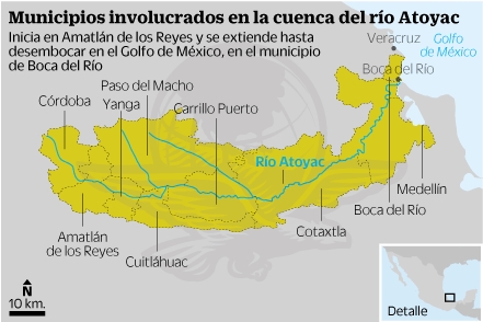
The River Atoyac, a river more than 120 kilometers (75 miles) long, in the state of Veracruz, has suddenly dried up. The dramatic disappearance of the river is believed to be due to the collapse of the roof of a cavern in the underlying limestone. This caused the formation of a narrow sinkhole, 30 meters (100 feet) long, that now swallows the river and diverts its water underground.

rio_atoyac-mapa-el-universal

Drainage basin of the Río Atoyac. Credit: El Universal

The collapse happened on Sunday 28 February; residents of the small ranch town of San Fermín heard a thunderous noise at the time. Within 48 hours, the river had disappeared.

The River Atoyac rises on the slopes of the Pico de Orizaba, Mexico’s highest peak. Unfortunately, the cavern collapse occurred only 3 kilometers from the river’s source, leaving almost all of its course dry, with potentially serious consequences for up to 10,000 people living in the river basin who have now lost their usual water supply.

The disappearance of the river will also have adverse impacts on fauna and flora, and jeopardize sugar-cane farming and other activities downstream. The fauna of the river included fresh-water crayfish (langostinos) which were an important local food source.

The municipalities affected are Amatlán de los Reyes, Atoyac, Yanga, Cuitláhuac, Felipe Carrillo Puerto, Cotaxtla, Medellìn and Boca del Río.

The course of the river approximately follows that of federal highway 150D, the main toll highway between the cities of Orizaba and Veracruz.

Related posts

Mexico’s tallest waterfalls

 Other, Updates to Geo-Mexico  Comments Off on Mexico’s tallest waterfalls
Aug 032015
 

As we saw in “How long is Mexico’s coastline?“, geographical “facts” and “records” are often not quite as simple to determine as might appear at first sight.

Take waterfalls for example. Mexico’s “highest” waterfalls are not necessarily the same as Mexico’s “tallest” waterfalls, since height refers to elevation, rather than stature. I’m not sure which is Mexico’s highest waterfall, but assume it is likely to be a small waterfall near the summit of one of Mexico’s many major volcanic peaks.

Mexico’s tallest waterfall, on the other hand, is well-known, or is it? Older sources still list the Cascada de Basaseachic in the Copper Canyon region of northern Mexico as the country’s tallest waterfall. That waterfall is 246 meters (807 feet) tall, according to geographer Robert Schmidt, a calculation subsequent confirmed by measurements made by members of a Mexican climbing expedition.

This short Postandfly video shows the Basaseachic Waterfall from the air:

The Basaseachic Waterfall is normally considered to operate year-round, though very little water flows over it on some occasions during the dry season.

In terms of total drop, however, and if we include waterfalls that are seasonal, the Basaseachic Waterfall is overshadowed by the nearby Cascada de Piedra Bolada (Volada). The Piedra Bolada Waterfall, has a total drop of 453 meters (1486 feet), but flows only during the summer rainy season. It is much less accessible, and its true dimensions were only worked out for the first time by an expedition as recently as 1995 by members of the Speology Group of Ciudad Cuauhtémoc, led by Carlos Lazcano.

This latter sections of this amateur video of the Piedra Bolada Waterfall show some of the amazing scenery in this remote area of Mexico:

Curiously, there is some debate as to whether this waterfall should be called Cascada de Piedra Volada (which would translate as the “Flying Stone Waterfall”) or Cascada de Piedra Bolada (“Round Stone Waterfall”). According to members of the Speology Group of Ciudad Cuauhtémoc, its true name is definitely Piedra Bolada, a name referring to a spherical stone, and used in addition for the local stream and for the nearest human settlement.

So, which is Mexico’s tallest waterfall? Well, it all depends…

Related posts:

30 top geotourism sites in Mexico (Geo-Mexico special)

 Index page  Comments Off on 30 top geotourism sites in Mexico (Geo-Mexico special)
May 142015
 

Mexico has literally thousands of geotourism sites (locations where the primary recreational attraction is some phenomenon of geographic importance, such as a coral reef, mangrove swamp, volcano, mountain peak, cave or canyon. Many of Mexico’s geotourism sites are geomorphosites, where the primary attraction is one or more ”landforms that have acquired a scientific, cultural/historical, aesthetic and/or social/economic value due to human perception or exploitation.” (Panniza, 2001)

Here is a partial index (by state) to the geotourism sites described on Geo-mexico.com to date:

Baja California Sur

Chiapas

Chihuahua

Colima

Hidalgo

Jalisco

México (State of)

Michoacán

Morelos

Nayarit

Nuevo León

Oaxaca

Puebla

Querétaro

Quintana Roo

San Luis Potosí

Sonora

Tamaulipas

Veracruz

Reference:

  • Panizza M. (2001) Geomorphosites : concepts, methods and example of geomorphological survey. Chinese Science Bulletin, 46: 4-6

How similar are Mexico’s two major deserts, the Sonoran Desert and the Chihuahuan Desert?

 Other  Comments Off on How similar are Mexico’s two major deserts, the Sonoran Desert and the Chihuahuan Desert?
May 292014
 

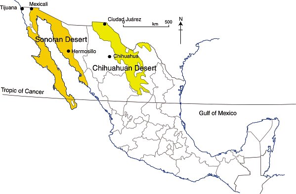
There are four desert areas in North America. Two of these areas (Great Basin and Mojave) are in the USA. The other two (the Sonoran Desert and the Chihuahuan Desert) are almost entirely in Mexico, but extend northwards across the border. The Sonoran Desert includes most of the Baja California Peninsula, together with the western part of the state of Sonora. The Chihuahuan desert is the northern section of the Central Plateau, including the northern parts of the states of Chihuahua.

The Chihuahuan Desert has been intensively studied by scientists interested in the possibility of life on Mars – see this New York Times article: Learning About Life on Mars, via a Detour to Mexico.

In a previous post – Why is northern Mexico a desert region? , we saw how the combination of the descending air of the Hadley Cell, which results in surface high pressure, and the effects of rain shadows resulting from neighboring mountain ranges contribute to the low annual rainfall total characteristic of both Mexico’s desert areas.

deserts-colorWhile these two deserts both experience an arid climate, they also have many differences.

Area

The Sonoran Desert has an area of about 311,000 square kilometers (120,000 sq mi). The Chihuahuan Desert has an area of about 362,000 square kilometers (139,769 sq mi).

Elevation

The Sonoran Desert is lower in elevation that the Chihuahuan Desert, with some parts (in the USA) lying below sea level. The Chihuahuan Desert varies in elevation from 600–1675 m (1969–5495 ft).

Summer temperatures

The Sonoran Desert tends to have higher summer temperatures than the Chihuahuan Desert, though even in the Chihuahuan Desert, daytime temperatures in summer are usually between 35 and 40̊C (95-104̊F).

Seasonal rainfall patterns

The ratio of winter to summer rainfall decreases from west to east. Most of the Sonoran Desert (to the west) has a bimodal rainfall regime with spring and summer peaks. On the other hand, most of the limited rain that falls in the Chihuahuan Desert comes in late summer.

The Chihuahuan Desert has a mean annual precipitation of 235 mm (9.3 in), though annual totals vary from 150 to 400 mm (6–16 in).

Vegetation, fauna and biodiversity

These seasonal rainfall differences result in significant differences in the vegetation of the two areas.

The bimodal precipitation in the Sonoran Desert provides two flowering seasons each year. Some plants bloom in spring, following winter rains, while others flower in late summer, following summer rains. Typical plants in the Sonoran Desert include columnar cacti (Cereus spp.) such as sahuaro, organ pipe, and cardon, as well as many other types of cacti, including barrels (Echinocereus), chollas (Opuntia spp.) and prickly pear (Opuntia spp.). Other succulent plants are also common.

More than 60 mammal species, 350 bird species, 20 amphibian species, 100 reptile species, 30 native fish species, 1000 native bee species, and 2000 native plant species have been recorded in the Sonoran Desert. The Sonoran Desert includes the Colorado River Delta, which was once an ecological hotspot within the desert, fueled by the fresh water brought by the river, though this flow has become negligible in recent years. See, for example, Will the mighty Colorado River ever reach its delta?

The vegetation of the Chihuahuan Desert is dominated by grasslands and shrubs, both evergreen and deciduous. Common species include tarbush (Flourensia ternua), whitethorn acacia (Acacia constrictor) and creosote bush (Larrea tridentata). The Chihuahuan desert has small cacti; succulent agaves (Agave spp.) and yuccas. Plants bloom in late summer, following the summer rains.

The Chihuahuan Desert is home to about 350 of the world’s 1500 known species of cactus, and includes the fascinating area of Cuatro Ciénegas, which has an unusually high number of endemic plant species and is one of the world’s richest hotspots for locally endemic cacti.

The Chihuahuan Desert is considered to be one of the three most biologically rich and diverse desert ecoregions in the world, rivaled only by the Great Sandy Tanmi Desert of Australia and the Namib-Karoo of southern Africa. However, settlements and grazing have heavily degraded the natural vegetation of some parts of the Chihuahuan Desert.

he Chihuahuan Desert has about 3500 plant species, including up to 1000 species (29%) that are endemic. The high rate of endemism (true for cacti, butterflies, spiders, scorpions, ants, lizards and snakes) is due to a combination of the isolating effects of the basin and range topography, climate changes over the past 10,000 years, and the colonization of seemingly inhospitable habitats by adaptive species. See here for more details of the flora and fauna of the Chihuahua Desert.

Landforms

This basin and range landscape of the Sonoran Desert trends north-northwest to south-south-east. Parallel faulted blocks are separated by alluvial bajadas (broad, debris-covered slopes), pediments and plains, which become wider approaching the coast. Despite being a desert area, this region exhibits many features that have resulted from water action, including wadis, salt flats, stream terraces and alluvial fans.

For a fuller description of the landforms of the Sonoran Desert, see this extract from A Natural History of the Sonoran Desert (edited by Steven J. Phillips and Patricia Wentworth Comus) published by the Arizona-Sonora Desert Museum.

The Sonoran Desert includes the subregion of the Sierra of Pinacate (part of El Pinacate and Gran Desierto de Altar Biosphere Reserve) with its distinctive volcanic cones, craters and lava flows. For more details, see The landforms of the El Pinacate and Gran Desierto de Altar Biosphere Reserve.

The landforms of the Chihuahuan Desert have been molded by tectonic uplift and erosion. Steep-sided but low hills are separated by wide bajadas from former lake beds and alluvial plains, occupying inland basins known as bolsons. Many parts form closed, interior basins with no external drainage. South of Ciudad Juárez, at Samalayuca, is one of Mexico’s most extensive areas of sand dunes. This is one of the most arid parts of the country, with high levels of salinization.

Related posts:

World’s longest underground river flows deep beneath the Yucatán Peninsula

 Other  Comments Off on World’s longest underground river flows deep beneath the Yucatán Peninsula
Feb 102014
 

In January 2007, the world’s longest underground river was reported from Mexico’s Yucatán Peninsula. [Prior to that date, the honor was held by the Puerto Princesa Subterranean River in the Philippines]

The Sac Actun (“White Cave”) river system in the Yucatán Peninsula wanders for 153 km (95 miles) through a maze of underground limestone caves. It took British diver Stephen Bogaerts and his German colleague Robbie Schmittner four years to explore the caverns using underwater scooters and specially rigged gas cylinders, before they finally discovered a connection between the Yucatán region’s then second- and third-longest cave systems, known respectively as Sac Actun and Nohoch Nah Chich (“Giant Birdcage”). Following the discovery of a link, the entire system is now known as Sac Actun. The system has a total surveyed length (including dry caves) of 319 kilometers (198 mi), making it the longest cave system in Mexico, and the second longest worldwide. [The longest is the dry Mammoth Cave System, Kentucky, USA, which measures 643.7 km (400 mi) in length].

Sac-Actun cave system

Sac-Actun cave system

Vying with Sac Actun for the title of longest surveyed underwater cave system is the nearby Sistema Ox Bel Ha (“Three Paths of Water”), also in the Tulum municipality of Quintana Roo. As of August 2013, surveys had measured 256.7 kilometers (159.5 mi) of underwater passages.

The underground passages and caverns of the Yucatán Peninsula have been a favored site for cave explorers for decades. Formal mapping of the systems has taken more than 20 years of painstaking work. Access to the systems is via the hundreds of sinkholes (cenotes) that litter the surface of the Peninsula. The Sac Actun system alone includes more than 150 cenotes.

Water management was critical to the Maya as they developed their advanced civilization in this area, a region with very limited surface freshwater. Many of the cenotes in the Yucatán Peninsula have archaeological importance and were utilized by the Maya for ceremonies. Perhaps the best-known (and most visited) cenote is the Sacred Cenote (cenote sagrado) at the archaeological site of Chichen Itza.

The caverns of the Yucatán Peninsula were formed as a result of the slow solution of limestone over thousands of years by percolating, slightly acidic, rainwater. In some cases, cave formations, such as stalactites and stalagmites, have later grown in the caves, formed drip-by-drip from the slow deposition of calcium carbonate from calcium-saturated ground water.

Because the average elevation of the Yucatán Peninsula is only a few meters above sea level, the water in many of the caves is “layered”, with a lens of freshwater overlying a layer of salt water. Rainwater that soaks into the ground becomes ground water, which then moves slowly along the watertable to eventually reach the ocean.

Cave researchers are worried that tourist developments in the Yucatán Peninsula will have adverse impacts on underground water systems, both in terms of water quantity (because of the amounts of fresh water extracted for domestic and tourist use) and in terms of water quality, because even point sources of water pollution (such as excess fertilizers from a golf course) could contaminate underground water supplies over a wide area.

Want to read more?

Related posts

The landforms of the El Pinacate and Gran Desierto de Altar Biosphere Reserve

 Other  Comments Off on The landforms of the El Pinacate and Gran Desierto de Altar Biosphere Reserve
Nov 092013
 

The breathtaking scenery of the El Pinacate and Gran Desierto de Altar Biosphere Reserve in the northern state of Sonora affords visitors a dramatic combination of two very distinct landscape types: volcanic landscapes (El Pinacate) in the east, and sand dunes (Gran Desierto de Altar) towards the west and south.

pinacate-map-googleVolcanic scenery (El Pinacate)

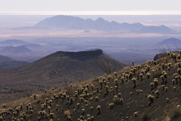
The eastern section of the Biosphere Reserve, El Pinacate, is a dormant volcanic area of around 200,000 ha (2000 sq. km), centered on the El Pinacate Shield (or Sierra Pinacate) which has 3 main peaks: Pinacate, Carnegie and Medio. The El Pinacate Shield is a composite structure, comprised of extensive, successive black and red lava flows, some more than 20 km long, seperated by desert pavement. The El Pinacate Shield boasts a wide array of volcanic phenomena and geological formations. Most of the lava is basaltic (alkaline) in composition, making it relatively fluid when molten; it is mainly of the aa (blocky) type, though some pahoehoe (ropy) lava is also found. The total volume of lava is estimated at between 150 and 180 km3.

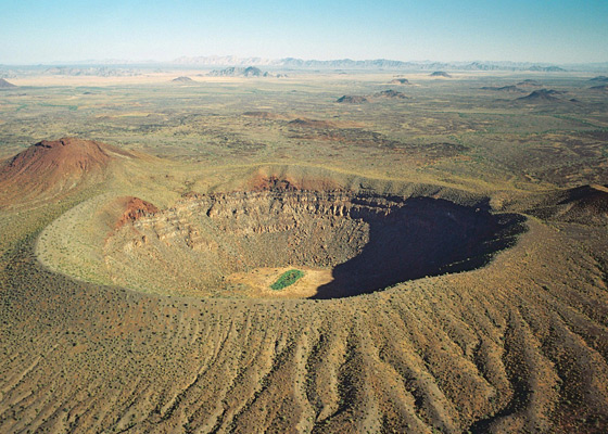
Elegante Crater, El Pinacate

Elegante Crater, El Pinacate (example of a maar) Credit: IUCN Tilman Jaeger

Besides the lave flows, the Pinacate area has more than 400 cinder cones (formed 1.2 million years ago) and several lava tubes. The lava flows and cinder cones are only a prelude to the most visually striking features in the reserve: 10 enormous, deep, and almost perfectly circular maars (steam explosion craters). Maars are believed to originate from a combination of explosion caused by groundwater coming into contact with hot lava or magma and subsequent collapse. The maars of El Pinacate are rivalled only by similar formations in Africa. The largest single maar is El Elegante, formed 32,000 years ago, which is 1,400 meters (4,600 feet) from rim to rim and 140 meters (460 feet) deep. It takes visitors a two to three-hour hike to reach its rim and be rewarded by a spectacular view.

The volcanic forms of El Pinacate are relatively recent in geological terms, most having been formed during the Quaternary Period, which began some 2.8 million years ago. The most recent volcanic activity in this area was only about 11,000 years ago. Some volcanologists believe that some of these craters could become active again in the future, with the potential to form volcanoes up to a few hundred meters in height.

Ron Mader, the founder of Planeta.com and a foremost authority on responsible tourism in Mexico, has marveled at the “bizarre and mind-boggling scenery” of El Pinacate., which so resemble the lunar landscape that between 1865 and 1970 it was used by NASA as a training ground for astronauts preparing for the moon landings. The lava field is so vast and sharply defined that it later turned out that the astronauts could easily recognize it from space!

Sand dunes (Gran Desierto de Altar)

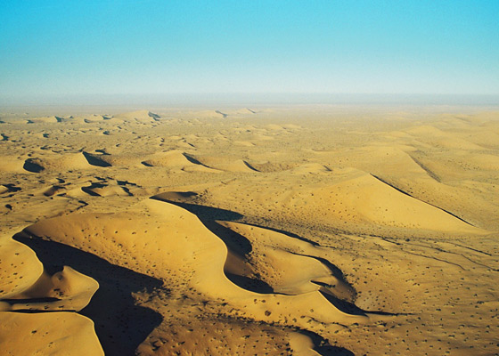
The western and southern parts of the El Pinacate and Gran Desierto de Altar Biosphere Reserve have entirely different scenery. The Gran Desierto de Altar is North America’s largest field of active sand dunes (erg). Several types of dunes are represented here, the tallest reaching 200 meters in height.

The sand needed to form and maintain these dunes comes from the fluvial and deltaic sediments of the Colorado River delta (to the west), the beaches of the Sea of Cortés/Gulf of California (to the south), the River Sonoyta (to the east) and the smaller river and stream fans formed in those parts of the reserve where there are volcanic and granitic mountains.

Sand dunes of Gran Desierto de Altar

Sand dunes of Gran Desierto de Altar

Prior to the opening of the Sea of Cortés (Gulf of California), vast amounts of sediment accumulated in this region brought by rivers of which little trace remains today. The creation of the Sea of Cortés, 5.3 million years ago, shortened the rivers and increased their average gradient (rejuvenation), causing them to cut into the pre-existing landscape leaving behind river terraces, remnants of the former higher level floodplains.

The fields of sand dunes of the Gran Desierto de Altar cover more than 550,000 hectares (5700 sq.km.) Several different kinds of sand dunes are found here–linear, crescent-shaped (barchans) and star-shaped–and they can be simple, compound or complex, depending on seasonal changes in the direction and strength of the wind.

Although linear dunes dominate (70%), crescent-shaped complex dunes and star-shaped dunes are of more interest because they exist in only a few locations in the world. Spectacular and very large star-shaped dunes, up to 200 meters high, occur both singly and in long ridges up to 48km in length. Star-shaped dunes possibly evolved from crescent dunes which changed their direction of movement becoming “reversing dunes”. Side winds may account for the multiple arms of some star-shaped dunes.

Other features – Granite massifs

In addition, there are several granite massifs (inselbergs), such as the Sierra del Rosario, emerging like islands from the sandy desert flats and dunes. They range in elevation from 300 to 650 meters above sea level. They represent another remarkable landscape feature harboring distinct plant and wildlife communities.

Main source:

Related posts:

Oct 242013
 

Mexico’s latest UNESCO World Heritage Site is the El Pinacate and Gran Desierto de Altar Biosphere Reserve in Sonora, added to the UNESCO list in June 2013. Mexico now has 32 World Heritage Sites.

The El Pinacate and Gran Desierto de Altar Biosphere Reserve is part of the Sonoran desert, which extends from Sonora into the northern part of Baja California, and across the U.S. border into Arizona and California. The reserve covers 714,566 hectares with an additional 354,871 hectares of buffer zone. It is a relatively undisturbed portion of the Sonoran desert, and offers visitors a dramatic combination of two very distinct landscape types: volcanic landscapes (El Pinacate) and sand dunes (Gran Desierto de Altar).

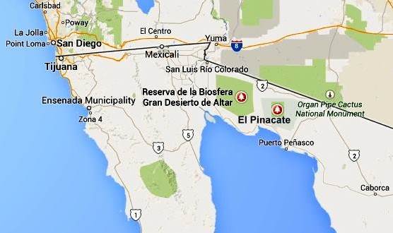
pinacate-map-googleThe biosphere reserve is immediately south of the U.S. border, west of the Lukeville (Arizona) – Sonoyta (Sonora) border crossing, and 50 km (30 miles) north of the fishing and tourist town of Puerto Peñasco. The San Luis Río Colorado–Sonoyta section of Mexican federal highway 2 (which runs from Mexicali to Caborca) skirts the northern section of the reserve. Puerto Peñasco is connected to Sonoyta by highway 8. There are entrances to the park from highway 2, 50 km west of Sonoyta, and from highway 8, mid-way between Sonoyta and Puerto Peñasco.

Despite being a desert area, most parts of the biosphere reserve do receive occasional rainfall, which gives this area more biodiversity than is true for most deserts.

El Pinacate and Gran Desierto de Altar Biosphere ReserveVaried scenery

The eastern section of the biosphere reserve, El Pinacate, is a dormant volcanic area of around 200,000 ha (2000 sq. km), centered on the El Pinacate Shield (or Sierra Pinacate) which has lava flows, cinder cones, lava tubes and circular maars (steam explosion craters). Ron Mader, the founder of Planeta.com and a foremost authority on responsible tourism in Mexico, has marveled at the “bizarre and mind-boggling scenery” of El Pinacate. The geology and landforms of this area so resemble the lunar landscape that between 1865 and 1970 NASA used it as a training ground for astronauts preparing for the moon landings. The lava field is so vast and sharply defined that it later turned out that the astronauts could easily recognize it from space!

The western and southern parts of the El Pinacate and Gran Desierto de Altar Biosphere Reserve are entirely different. The Gran Desierto de Altar is North America’s largest field of active sand dunes (erg), more than 550,000 hectares (5700 sq.km.) in area. Several types of dunes are represented here, the tallest reaching 200 meters in height, including linear, crescent-shaped (barchans) and star-shaped dunes.

Flora and Fauna

The highly diverse mosaic of habitats in the biosphere reserve is home to complex communities and a surprisingly high species diversity. More than 540 species of vascular plants, 44 mammals, more than 200 birds and over 40 reptiles inhabit this seemingly inhospitable desert. All feature sophisticated physiological and behavioural adaptations to the extreme environmental conditions. Insect diversity is high, though not fully documented. Several endemic species of plants and animals exist, including two freshwater fish species.

The flora in Sierra Pinacate includes the sculptural elephant tree (Bursera microphylla). The name “Pinacate” derives from pinacatl, the Nahuatl word for the endemic desert stink beetle. The biosphere reserve has large caves inhabited by the migratory lesser long-nosed bat (Leptonycteris curasoae yerbabuenae), which is an important pollinator and seed dispersal vector, and the endangered fish-eating bat (Myotis vivesi); both species are endemic.

Other noteworthy species in the reserve include the threatened Sonoran pronghorn (Antilocapra americana sonorensis), an endemic subspecies of restricted habitat and the fastest land mammal in North America; bighorn sheep (Ovis canadensis mexicana), the mule deer (Odocoileus hemionus) and gray fox (Urocyon cinereoargenteus), the Gila monster (Heloderma suspectum) and desert tortoise (Gopherus agassizii).

Human occupation and use

El Pinacate and Gran Desierto de Altar contains numerous archaeological remains, some dating back more than 20,000 years. It is an important cultural site for the indigenous Tohono O’odham people who consider El Pinacate peak, where they still perform sacred ceremonies, as the place where  creation occurred.

Management issues

The El Pinacate section of the biosphere reserve was first designated a “protected area” in 1979. In 1993, it was a declared a Biosphere Reserve, along with the Gran Desierto de Altar, by then president Carlos Salinas de Gortari. The biosphere reserve is managed by Mexico’s National Commission of Natural Protected Areas (Conanp), in collaboration with the Sonora state government and the Tohono O’odham people.

The number of people visiting the reserve has risen rapidly from fewer than 6,000 in 2000 to more than 17,500 in 2010. The two major challenges that management needs to take into account are how to ensure that indigenous views about the reserve’s use are respected, and how to limit negative impacts on the reserve from nearby tourism developments.

The potential negative impacts include:

  • increased vehicle traffic, resulting in ecological disturbance, littering and wildlife road kills.
  • pressure to extend the limited existing road infrastructure by adding new roads, though this might lead to more exotic (alien) invasive species.
  • increased habitat damage from the growing use of off-road vehicles

UNESCO considers that, “The most critical long term management issue is to address potential problems derived from tourism-related water consumption.”

Given that this reserve is on the Mexico-U.S. border, transboundary cooperation is essential, and UNESCO actually recommends that the best way forward is to establish a Transboundary Protected Area, extending into Arizona.

The combination of a volcanic shield with spectacular craters and lava flows, almost entirely surrounded by an immense sea of dunes, makes this an area of great scientific interest, and an ideal laboratory for researchers interested in geology and geomorphology.

[Note: This post makes extensive use of UNESCO’s description of the biosphere reserve, with additional information from a variety of other sources.]

Want to read more?

Related posts:

Geotourism in Mexico: García Caves (Grutas de García) in Nuevo León

 Other  Comments Off on Geotourism in Mexico: García Caves (Grutas de García) in Nuevo León
Oct 032013
 

The Garcia Caves (Grutas de García) are located in the Cumbres de Monterrey National Park, 9 km from the small town of Villa de García, and about 30 km from the city of Monterrey (state capital of Nuevo León). The highest point in the park is Copete de las Águilas which rises to 2260 m (7,410 ft) above sea level, but its best known peak is Saddle Hill (Cerro de la Silla), the distinctive saddle-shaped hill that overlooks the city.

Much of the park, including the mountains, are composed of sedimentary rocks that were originally laid down as marine sediments and then subsequently folded, uplifted and exposed to erosion. The extensive areas of limestone in the park, which date from the Cretaceous period, have been subject to karstification over 50 to 60 million years, which has resulted in typical karst landforms such as sinkholes, caves, cave formations and underground streams.

The Garcia Caves, one of the largest cave systems in Mexico, are deep inside the imposing Cerro del Fraile, a mountain whose summit rises to an elevation of 1080 meters above sea level, more than 700 meters above the main access road. The entrance to the caves is usually accessed via a short ride on a 625-meter cable car that was built to replace a funicular railway.

The cave system was first reported in 1843 by the Marmolejo family who informed their local prist Juan Antonio Sobrevilla that they had stumbled across it while looking for firewood.

Grutas de García. Credit: María de Lourdes Alonso

Grutas de García. Credit: María de Lourdes Alonso

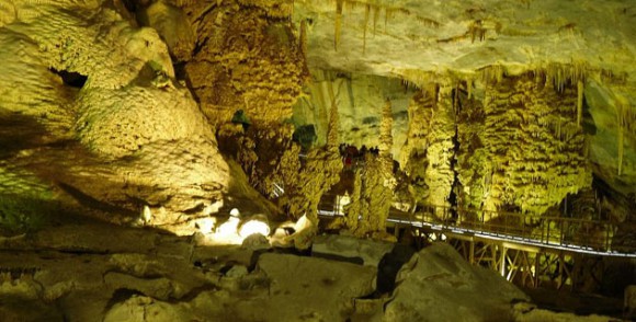
Guided tours of the cave system show visitors some of its 27 separate chambers along a 2.5-kilometer (1.6 mile) route. The full system extends more than a kilometer further into the mountain reaching depths of more than 100 meters (340 feet) beneath the surface. The limestone of the cave walls contains lots of marine fossils. The caves have extensive and impressive formations of dripstone, including stalactities, stalagmites and other forms.

Unlike the suffocating heat of the Naica Crystal Caves in Chihuahua, the cave temperature here remains about 18̊C (65̊F) all year.

The chambers and formations have been given whimsical and imaginative names such as

  • “El salón de la luz” (The Light Chamber) where the natural translucence of the ceiling rock allows light from the outside to filter through.
  • “La octava maravilla” (The Eighth Wonder), a natural column formed where a stalagmite growing from the floor joined a stalactite, growing from the ceiling
  • “El mirador de la mano”, a stalagmite shaped like a human hand.
  • “El Nacimiento” (The Nativity),
  • “La Fuente Congelada” (The Frozen Fountain),
  • “La Torre China” (The Chinese Tower),
  • “El teatro” (The Theatre), and
  • “El Árbol de Navidad” (The Christmas Tree).

Want to read more about caves in Mexico?

Visit John Pint’s website for a selection of his writing, with many original articles, illustrated with great photographs, about many individual caves in Mexico.

Related posts

The volcanic calderas of Mexico’s Volcanic Axis

 Maps, Other  Comments Off on The volcanic calderas of Mexico’s Volcanic Axis
Jul 082013
 

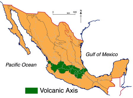
There is still lots of work needed to fully unravel the geological secrets of Mexico’s Volcanic Axis which crosses the country between latitudes 19̊ and 21̊ North. Unlike most volcanic belts elsewhere in the world, this one does not appear at first sight to correspond to any plate boundary. Another of the mysteries of this volcanic region, where igneous upheavals have shaped the landscape for several million years, is the relative dearth of calderas, the “super craters” formed either by collapse or by giant explosions.

While the toponym La Caldera is used fairly commonly in Mexico’s volcanic regions for a volcano or volcanic crater, geologists restrict the term to the much larger landform that results from the collapse or super-explosion of a volcano. Even so, there is still some debate among specialists as to the precise definition of the term caldera.

Geologists have proposed a threefold division of the Volcanic Axis, based on differences in the volcanic landforms, in terms of their type, structure, age, morphology and chemistry.

volcanic-axis

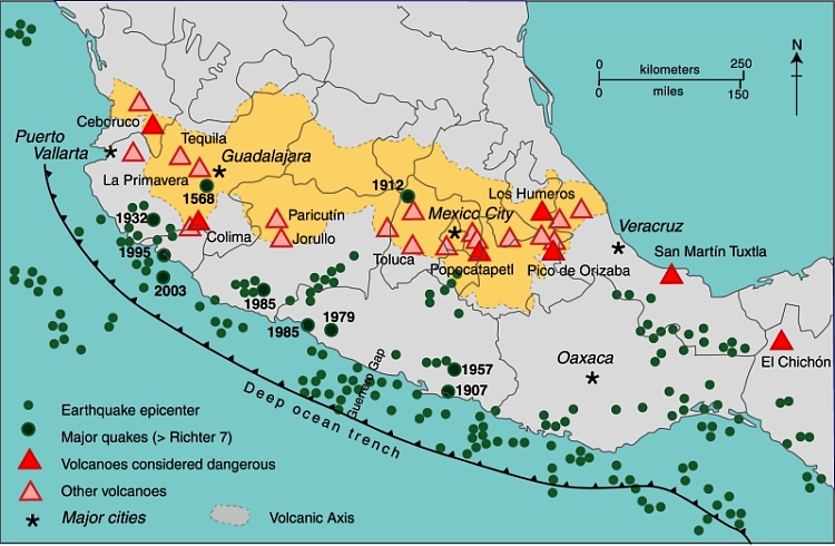
The western sector (see map below) extends from the western coast of Mexico to Lake Chapala (including the lake basin). The central sector covers the area between Lake Chapala and the twin volcanoes of Popocatepetl and Ixtaccihuatl, close to Mexico City. The eastern sector includes these twin volcanoes and extends as far as Mexico’s Gulf Coast.

Mexico's Volcanic Axis (Fig 2.2 of Geo-Mexico, the geography and dynamics of modern Mexico. All rights reserved.

Mexico’s Volcanic Axis (Fig 2.2 of Geo-Mexico, the geography and dynamics of modern Mexico). All rights reserved.

The only caldera recognized in the western section is that of La Primavera, the forested area west of Guadalajara, whose formation we considered in

In the central and eastern sections of the Volcanic Axis, several other calderas have been recognized. They include (from west to east):

  • Los Azufres
  • Amealco
  • Mazahua
  • Huichapan
  • Los Humeros
  • Las Cumbres

Los Azufres

The precise origin of the Los Azufres caldera, in Michoacán, is still debated. The caldera is the site of an important geothermal power station with an installed capacity of 188 MW. (Mexico is the world’s fourth largest producer of geothermal energy, after USA, the Philippines and Indonesia.) The geothermal heat in this area is also used to heat the cabins in a local campground, and to dry wood and process fruit.

Amealco

The Amealco caldera is in the central part of the Mexican Volcanic Axis, midway between the towns of San Juan del Río and Maravatio. It dates from Pliocene times and has been heavily eroded since. It is about 11 km wide and 400 m deep and was the origin of great sheets of pyroclastic flow deposits (ignimbrites) with a total volume of around 500 cubic km.

Mazahua

Mazahua is a collapse caldera, 8 km in width, near the village of San Felipe del Progreso in the western part of the State of Mexico.

Huichapan

The Donguinyó-Huichapan caldera complex is 10 km in diameter and in the central sector of the Volcanic Axis. It appears to be two overlapping calderas, dating from around 5 million and 4.2 million years ago respectively. The rocks from the older caldera are intermediate to basic in composition, while those from the more recent caldera are acidic (high silica) rhyolites.

Los Humeros

The Los Humeros caldera is in the state of Puebla, close to its border with Veracruz. It is 55 km west-north-west of the city of Xalapa (Veracruz), relatively close to Teziutlán (Puebla). The main caldera (summit elevation 3150 m) is about 400 m deep and roughly oval in shape, with a diameter which varies from 15 to 21 km. It was formed about 460,000 years ago by the collapse of the underground magma chamber. Prior to collapse, lava emitted from this vent had covered 3500 square km with ignimbrite. Later, two smaller calderas formed nearby, with ages of about 100,000 years (Los Potreros caldera) and 30,000 years (El Xalapazco) respectively. Volcanic activity in this area has been utilized to produce generate geothermal power (installed capacity: 40 megawatts).

Las Cumbres

The easternmost caldera in Mexico is Las Cumbres, 15 km north of Pico de Orizaba, Mexico’s highest volcano, and close to the state boundary between Puebla and Veracruz. The Las Cumbres caldera was originally believed to be an explosion super-crater, but geologists now think that it was created due to the partial collapse of the eastern flank of the original volcano, between 40,000 and 350,000 years ago. The collapse of the side of Las Cumbres produced a huge debris avalanche (total volume estimated at 80 cubic km, which extended up to 120 km in the direction of the Gulf of Mexico.

Lake Alchichica

According to Dra. Esperanza Yarza de la Torre in Volcanes de México (UNAM; 1984), Lake Alchichica in the Oriental Basin near Puebla occupies another caldera. The basin has several shallow lakes, known locally as axalpazcos (“sandy basin with water” in the indigenous Nahuatl language). These occupy shallow craters (or in one case a caldera) and are largely sustained by ground water. The largest of the lakes, in a caldera, is Lake Alchichica, which has a diameter of 1888 meters, an area of 1.81 square km, and lies at an elevation of 2320 meters above sea level. The rim of the caldera rises 100 m above the lake level. The lake is used for irrigation. This lake is claimed to be Mexico’s deepest natural lake with a maximum depth of 64 meters, and a mean depth of 38.6 meters.

Main sources:

  • Gerardo J. Aguirre-Díaz & Fred W. McDowell. 1999. Volcanic evolution of the Amealco caldera, central Mexico. United States Geological Society. Special Paper 334.
  • Esperanza Yarza de la Torre. 1984. Volcanes de México. UNAM.

Want to read more?

  • Use the site’s tag system (left hand side of the page) to find lots more posts about Mexico’s volcanoes, geology and landforms.

Watch La Primavera’s geological history unfold via a short video animation

 Books and resources  Comments Off on Watch La Primavera’s geological history unfold via a short video animation
Jun 292013
 

Only days after we published our third post about the Primavera Forest, near Guadalajara, we were alerted to an excellent 9 minute video animation of how the area was formed. This short video about “The Exciting Geology of Bosque La Primavera” was produced by geologist Barbara Dye during her stint as a Peace Corps volunteer in Mexico.

The video can also be viewed in Spanish:

Dye has also written a beautifully-illustrated 72-page guide (in Spanish) to the geology of the Primavera Forest, entitled “La Apasionante Geología del Área de Protección de Flora y Fauna La Primavera.

Previous posts about La Primavera:

How was the Primavera Forest caldera in Jalisco formed?

 Other  Comments Off on How was the Primavera Forest caldera in Jalisco formed?
Jun 102013
 

In a previous post, we described the considerable geotourism potential of the Primavera Forest near Guadalajara:

In this post, we take a closer look at how this unusual area was formed.

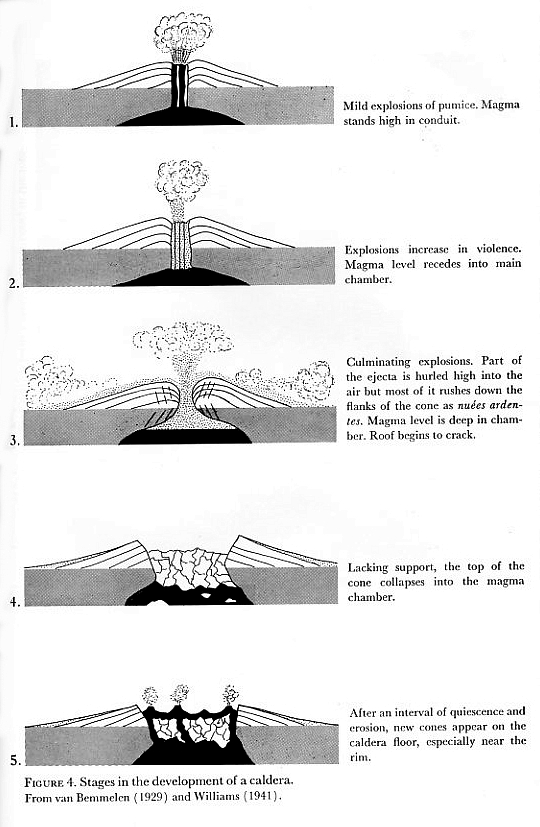
Stages 1 and 2 (see diagram):

140,000 BP. The magma chamber beneath the surface began to fill with magma (molten rock underground) and grow in size.

By about 120,000 BP, several lava flows and domes had formed, made primarily of rhyolite, a silica-rich (“acid”) igneous rock. After each eruption, the magma level underground would subside for a period of time before pressure built up again towards the next eruption.

Formation of a caldera

Fig. 4 of Bullard (1962) “Volcanoes in history, in theory, in eruption”. Based on van Bemmelen (1929) and Williams (1941)

Stages 3 and 4

So much pressure had built up by about 95,000 BP that there was a huge explosion, sending 20 cubic kilometers (4.8 cubic miles) of rock and ashes high into the sky. The explosion covered 700 square kilometers (270 square miles) with volcanic materials, known today as the Tala tuff (tuff is the geological term for consolidated ash). This massive explosion caused the upper part of the magma chamber to collapse, leaving a caldera that was 11 kilometers (6.8 miles) wide. The Tala tuff includes large quantities of pumice, a light and porous volcanic rock formed when a gas-rich froth of glassy lava solidifies rapidly.

This caldera filled with water, creating a lake.

Stage 5

This stage began shortly afterwards when a series of ring domes were erupted around the edge of the caldera as the magma deep below the surface started to push upwards again, eventually forming small islands in the lake. These eruptions formed more pumice, blocks of which would break off and start to float across the lake as they gradually sank to the lake floor.

A further series of eruptions in about 75,000 BP led to a second series of ring domes. A combination of tectonic uplift and sedimentation had filled the lake in by about this time.

More volcanic domes have been created at approximately 30,000 year intervals since, in about 60,000 BP and about 30,000 BP; these domes were almost all on the southern and eastern margins of the caldera, and include the lava domes of El Colli and El Tajo on the outskirts of Guadalajara.

Many geologists appear quietly confident that lava and ash eruptions in La Primavera are a thing of the past. They consider that the Primavera Forest’s fumaroles, hot river and hot waterfall represent the last vestiges of vulcanism and are no cause for alarm. On the other hand, others, including Gail Mahood who has studied this area far more than most, warn that hazard monitoring is justified in the case of La Primavera given its proximity to a major city and bearing in mind that any future eruption would be likely to occur on the southern and/or eastern side of the caldera.

The La Primavera Forest is only one of several calderas in Mexico’s Volcanic Axis.

If you prefer a short 9 minute video animation of how the area was formed, try this excellent YouTube video: “The Exciting Geology of Bosque La Primavera“, produced by geologist Barbara Dye during her stint as a Peace Corps volunteer in Mexico.

References:

  • Mahood G. A. 1980. Geological evolution of a Pleistocene rhyolitic center – Sierra La Primavera, Jalisco, Mexico. Journal of Volcanology and Geothermal Research, 8: 199-230.
  • Mahood, G.A. 1981. A summary of the geology and petrology of the Sierra La Primavera, Jalisco, Mexico. Journal of Geophysical Research, Volume 86.
  • Dye, Barbara. 2013. “La Apasionante Geología del Área de Protección de Flora y Fauna La Primavera”.

Related posts:


The distinctive street pattern of Venta de Bravo, Michoacán

 Other  Comments Off on The distinctive street pattern of Venta de Bravo, Michoacán
Jan 262013
 

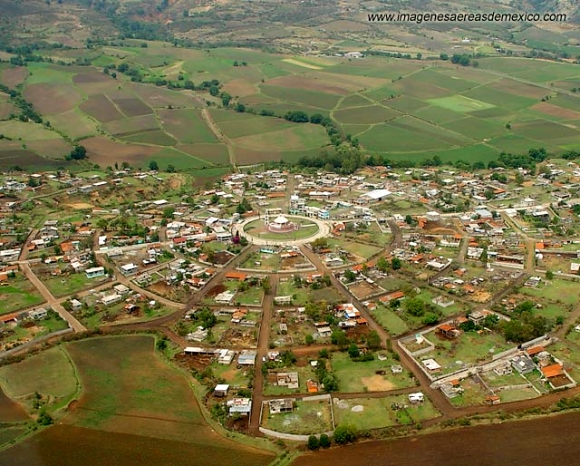
The small settlement of Venta de Bravo, in the municipality of Contepec in the state of Michoacán, has a very distinctive street pattern. As the image shows, it has a circular “center”, surrounded by a series of concentric circular streets (see image), connected via regularly-spaced radial streets. The regularity of the pattern is not quite perfect. Based on the photo, the imperfections probably result from variations of topography.

Venta de Bravo, Michoacán. Credit: imagenesaereasdemexico.com

Venta de Bravo, Michoacán. Credit: imagenesaereasdemexico.com

The village has about 1300 inhabitants and is at an elevation of 2290 meters above sea level. This is clearly a “planned settlement”, and one almost certainly quite modern in origin. I haven’t ever visited Venta de Bravo and don’t know its history, but would certainly be interested in finding out more if you have any pertinent information or can suggest likely sources.

An online search for Venta de Bravo will turn up numerous articles about the seismically active 45-km-long Venta de Bravo fault, as well as references to the small “Rayón National Park” which is only a few kilometers away in the Sierra of Tlalpujahua and extends as high as 2770 meters above sea level (Cerro del Gallo).

The Teziutlán disaster of 5 October 1999, a case study of vulnerability

 Other  Comments Off on The Teziutlán disaster of 5 October 1999, a case study of vulnerability
Oct 042012
 

Today marks the 13th anniversary of a major disaster that struck Teziutlán (current population about 65,000), a small city in the Eastern Sierra Madre, in the northeast corner of the state of Puebla, close to the border with Veracruz. The city is noteworthy as the birthplace of two prominent twentieth-century politicians: Manuel Ávila Camacho (served as President, 1940–1946) and Vicente Lombardo Toledano, who founded the Confederación de Trabajadores de México (CTM), Mexico’s largest confederation of labor unions.

The town’s name means “place of the hailstones”. But in 1999, it was not hailstones but torrential rain that triggered the major disaster of 4/5 October, with parts of the city destroyed by a series of landslides and mudflows. More than 80 municipalities were affected to some degree by this tremendous storm. Hundreds of landslides occurred in Hidalgo, Veracruz and Puebla states, causing an estimated US$457 million worth of damage, and at least 260 deaths.

This post focuses only on the consequences for Teziutlán where several hundred homes were completely destroyed and almost a thousand homes suffered partial damage. More than 100 Teziutlán residents lost their life. The local infrastructure, roads, housing, schools and farming were all severely impacted.

The worst damage was in the La Aurrora district on the eastern side of the city, where a landslide on a 23-degree slope buried more than 130 people. In another district, La Gloria, in the western part of the city, several more slips, flows and slides damaged homes, but without any fatalities.

With the benefit of hindsight, this disaster offers a good case study of the factors which made the inhabitants of Teziutlán particularly vulnerable to such an event. The diagram suggests one general classification of the multitude of factors that can affect vulnerability. In the case of Teziutlán, the discussion that follows suggests that the physical factors were probably the most significant.

factors affecting vulnerability

Factors affecting vulnerability (Geo-Mexico, Figure 7.2) All rights reserved.

Physical factors

1. Relief and geology. The area ranges in elevation from 300-2,280 meters above sea level and is drained by the El Calvario, Xóloatl and Xoloco rivers. The city is located at the southern limit of the Eastern Sierra Madre (Sierra Madre Oriental), very close to where it is truncated by the geologically more recent Volcanic Axis. The local geology includes a series of loosely compacted, pumice-rich pyroclastic flows, most of which are thought to be associated with the Los Humeros caldera. These deposits are interlaced with palaeosoils rich in clay which are impermeable and restrict the infiltration of rainwater, and overlie older folded rocks. The combination of steep slopes and impermeable, unconsolidated layers increases the risk of landslides and other forms of mass movement.

2. Climate.  This mountainous region is one of the most humid and foggiest in Mexico, averaging 280 days of mist or fog each year. Teziutlán has an average precipitation of 1600 mm/yr, though totals of over 2000mm are not that uncommon. Most rain falls between July and October.On 4 October 1999, a moist tropical depression off the coast of Veracruz was prevented from moving by a cold front. This led to an increase in humidity followed  by torrential downpours (over 300 mm of rain) over Teziutlán and the surrounding area. The storm continued the next day when a further 360 mm of rain fell.  The rain that fell on just those two days was equivalent to about 40% of Teziutlán’s usual total for an entire year.

3. Earthquake A few days prior to the storm, on 30 September 1999, a 7.4-magnitude earthquake occurred off the coast of Puerto Escondido (Oaxaca). This earthquake did cause  minor cracks in some homes in Teziutlán, and it possibly played a (minor) contributory role in the severity of the storm’s impacts.

Environmental

Deforestation, as a consequence of unplanned urban growth, was also important. Natural and secondary woodlands were steadily being cleared for construction and agriculture. This had an adverse effect on infiltration rates and the capacity of the land to absorb rainwater. However, given the extreme magnitude of the rainfall event, it is unlikely that the area would have escaped unscathed, even if the natural forest had remained.

In the La Aurrora district, where a landslide/mudflow buried more than 130 people, the construction of  a cemetery on a hill above La Aurrora may have played a part, since it appears that a cemetery wall held rainwater back, allowing more of it to seep into the underlying slope, increasing its susceptibility to a serious slide.
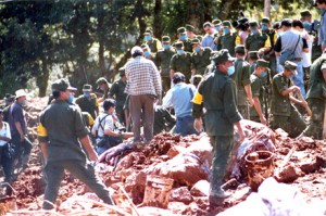
La Aurrora, October 1999. Credit: Periódico Sierra Norte

La Aurrora, October 1999. Credit: Periódico Sierra Norte

Educational

The town had suffered severe mass movements during prior storms. For example, in 1955, the rains that accompanied Hurricane Janet provoked numerous mass movements resulting in the disruption of transport systems, including the main highway, but with no loss of life. However, in general, it is clear that these prior events did not increase Teziutlán’s preparedness for a similar event in the future. In particular, prior events did not lead to building regulations being enforced or prevent buildings from being erected in high-risk areas.

Social/Demographic

In the period following the last major event (in 1955), the population of Teziutlán had increased rapidly, leading to the equally rapid expansion of the urban area. This was uncontrolled and included construction on steep slopes with insufficient attention to stability or possible mass movement mitigation measures being taken. It is worth noting that the population has continued to increase rapidly since the disaster, too.

Economic

Home owners in Mexico do not generally carry insurance on their properties, and even when they do, it often specifically excludes major meteorological events. It is unlikely that any of the residents of Teziutlán were able to make insurance claims. Many of the those affected would not have had savings and would have been forced to rely on family, friends and emergency hand-outs to survive. As a 1999 BBC News article emphasizes, government help was slow to arrive.

Want to see more?

There are several Youtube videos with images of the disaster. Perhaps the most interesting is TEZIUTLAN 1999 – 10 años Después del desastre  because it includes some clips from an investigative 1995 TV program aired in 1995 (four years prior to the landslide) that highlighted the extreme risk of constructing unauthorized buildings on the steep slopes of the town along the main highway. This video includes many excellent photos [warning: some graphic images] of the landslide and its aftermath, with a commentary [in Spanish].

Other valuable Youtube resources include Teziutlan Desastre 1999 which has additional photos, plus some eyewitness memories of the event [in Spanish], and TEZIUTLAN historia y tragedia which has many photos of the disaster, accompanied by music only (no commentary) making it a good choice for English-speaking classes.

Sources:

Alcántara-Ayala, I.  Flowing Mountains in Mexico. Mountain Research and Development, Vol 24, No. 1, Feb. 2004: 10-13.

Flores Lorenzo, Pablo & Irasema Alcántara Ayala. Cartografía morfogenética e identificación de procesos de ladera en Teziutlán, Puebla. Boletín del Instituto de Geografía, UNAM. #49, 2002, pp. 7-26. [pdf file]
 

How were the canyons in the Copper Canyon region formed?

 Other  Comments Off on How were the canyons in the Copper Canyon region formed?
Aug 062012
 

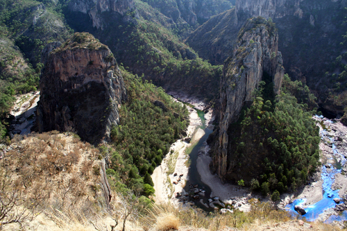
According to a local Tarahumara Indian legend, the canyons were formed when “a giant walked around and the ground cracked.” However, geologists believe that a sequence of volcanic rocks varying in age from 30 to 135 million years was slowly uplifted to an average elevation of 2275 m (7500 ft) while being dissected by rivers.

Mexico's Copper Canyon

Where did the rocks come from?

The Sierra Tarahumara is part of the Western Sierra Madre, an extensive volcanic tableland, affected by grabens (rift‑valley faulting) and faults which deprive it, especially on its flanks, of any homogeneous appearance. Its eastern side merges gradually into the Chihuahua basin and range landscape; its western side is much steeper, marked by major normal faults of considerable vertical extent, and by deep canyons.

Stage 1. The lower rocks.

McDowell and Clabaugh (1979) describe two different igneous sequences, which were separated in time by a prolonged period of non‑activity. The older series is mainly comprised of intermediate igneous rocks between 100 and 45 million years old; it shows evidence of lava flows and violent eruptive activity which produced andesitic pyroclasts. There are also layers of siliceous ignimbrites. This lower series includes many rich mineral deposits, though it outcrops in only restricted parts of the Canyon system. The volcanic activity in this area was associated with the subduction of the small (now destroyed) Farallon Plate which was pushed beneath the North American Plate by the expanding Pacific Plate. The line between the lower, older series and the higher, newer one is very irregular, indicating intensive erosional activity in the period between their times of formation.

Stage 2. A break in activity allowing erosion to take place.

The major lull in volcanic action, between 45 and 34 million years ago, may have been due to a change in the inclination of the subducting Farallon plate.

Stage 3. The upper rocks.

After this break in activity, there was a sudden resumption of vulcanism. The upper series is the most extensive cover of ignimbrite known anywhere in the world, covering an area which is 250 km wide, and 1200 km long from NW to SE. It stretches as far north as the southern USA. To the south, it disappears beneath the newer volcanic rocks of Mexico’s Volcanic Axis in Jalisco and Michoacán. The ignimbrites are rhyolitic and rhyo‑dacitic in composition, generally approximately horizontal, or slightly tilted, and with ages between 34 and 27 million years. In places, these ignimbrites are more than 1000 m thick (Demant & Robin, 1965).

It is unclear precisely where all these volcanic rocks originated. One estimate is that for such large volumes of rock to have been formed, there would have been between 200 and 400 volcanic outlets, some up to 40 km across. An alternative hypothesis (proposed by Aguirre-Díaz & Labarthe-Hernández) is that large bodies of magma (molten rock underground) reached shallow parts of the crust and then partially erupted, explosively, along the fault lines of the existing basin and range structures.

The common rock types in the Copper Canyon region

Volcanic Ash is unconsolidated fragments <2 mm in diameter. Volcanic ash commonly contains larger (up to 64 mm) fragments called lapilli. Ash may be composed of crystalline rock (eg. rhyolitic and andesitic ashes), of glassy fragments (vitric ash), or of individual crystals (crystal ash). In general, the size of individual particles comprising the ash diminishes as distance increases from the volcano where it originated.

Tuff is consolidated volcanic ash.

Ignimbrites are essentially pieces of light, vesicular, pumice, in a matrix of glassy fragments. Ignimbrites are often layered and sometimes split into vertical columns. They are deposited from ash flows that included large volumes of hot, expanding gases and incandescent glass fragments.

Lavas (molten rock on the surface). When lava cools and solidifies, it produces massive (as opposed to fragmentary) rocks, generally crystalline but of variable chemical composition (andesite, rhyolite, basalt).

The major landforms of the Copper Canyon region

These layers of igneous rocks were uplifted, forming a plateau with an average elevation of 2275 m (almost 7500 feet). Rivers have carved deep gashes, up to 1400 m deep, into the plateau surface, forming a series of steep-walled canyons, separated by giant blocks, remnants of the original, continuous plateau.

Incised meanders near Umira, Chihuahua

Incised meanders near Umira, Chihuahua

Since some of the rivers exhibit superb examples of incised meanders [see photo], some, possibly most, of these rivers already existed prior to the main periods of uplift. They were meandering across a gently sloping flood plain prior to the tectonic upheavals. Then, as the landscape slowly rose around them, they carved these giant canyons. These antecedent rivers retained their courses; the meanders were incised into the landscape.

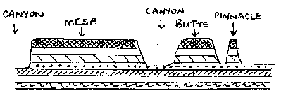
Centuries of erosion by the various rivers, including the Urique river and its tributaries, have resulted in the present-day landscape of structurally-guided plateau remnants, termed mesas, buttes and pinnacles (depending on their size). There are many examples of these distinctive landforms in the Copper Canyon region.

Landforms resulting from dissection of a plateau

Landforms resulting from the dissection of a plateau

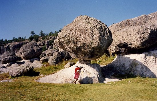
It is likely that some of the many waterfalls in the region were formed in places where the downward vertical erosion of rivers was insufficiently powerful to counteract the forces of uplift. Other waterfalls are more likely to have resulted from differences in the relative resistance of different rocks. The effects of differential erosion are noticeable in many smaller-scale features in this landscape, such as perched “mushroom” rocks.

Perched block near San Ignacio

Perched block near San Ignacio. Photo: Tony Burton; all rights reserved

Examples of many of these landforms can be seen by anyone driving along the Creel-Batopilas road. At km 5 (from Creel) is the entrance to the Mission village of San Ignacio, near which are strange tor‑like rock formations, including “mushroom” rocks, where a more resistant capstone sits perched atop weaker rocks that are slowly being eroded away.  At km 20 in  Cusárare, a short walk south of the road through woods and along the Cusárare river leads to the very pretty 30-metre high Cusárare waterfall. At km 44 (Basihuare), there are fine views of a mesa of pink and white rocks that overlooks the road. This is Cerro el Pastel (“Cake Mountain”) with its pinnacles. At km 56, near  Umirá (or Humirá) are several spectacular incised meanders formed when the river’s course was preserved while the surrounding land was undergoing relatively rapid uplift.

Small wonder that the Copper Canyon region is one of Mexico’s most important geomorphosites!

Sources:

  1. Aguirre-Díaz, Gerardo J. & Guillermo Labarthe-Hernández. 2003. Fissure ignimbrites: Fissure-source origin for voluminous ignimbrites of the Sierra Madre Occidental and its relationship with Basin and Range faulting. Geology September, 2003 v. 31, no. 9, p. 773-776
  2. Gajdusek, D.C. (1953) “The Sierra Tarahumara” in Geographical Review, New York. 43: 15‑38
  3. Demant, A & Robin, C (1975) “Las Fases del vulcanismo en Mexico” Revista Instituto de Geologia, UNAM, Mexico City. 75 (1) pp 70‑83
  4. Schmidt, R.H. (1973) A Geographical Survey of Chihuahua, monograph #37 Texas Western Press.
  5. McDowell, F.W. & Clabaugh, S.E. (1979) “Ignimbrites of the Sierra Madre Occidental and their relation to the tectonic history of western Mexico” in “Ash flow tuffs” edited by Chapin, C.E. & Elston, W.E., Geol. Soc. of America special paper # 180.

Related posts:

The seven main canyons in the Copper Canyon region

 Other  Comments Off on The seven main canyons in the Copper Canyon region
Jul 302012
 

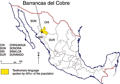
The Copper Canyon region in Mexico is the informal name for the area, in the south-west part of Chihuahua state, where several deep canyons bisect the Sierra Tarahumara. The 10,000 km2 area, part of the Western Sierra Madre, is home to about 50,000 Tarahumara Indians, one of the largest native Indian groups in North America. While generally referred to in English as the Tarahumara, the people’s own name for themselves is Raramuri“, literally “the light‑footed ones” or “footrunners”.

Location of Barrancas del Cobre (Copper Canyon region)

Location of Barrancas del Cobre (Copper Canyon region)

While the Tarahumara have so far succeeded in keeping many aspects of their distinctive culture relatively unadulterated, the pressures on them have increased considerably in recent years as improving highway links have made the region more accessible, not only to tourists, but also to developers looking to exploit the region’s forest and mineral resources.

Spanish-speakers usually refer to this region as the “Barrancas del Cobre” (Copper Canyons, plural). The table shows the seven main canyons, only one of which, strictly speaking, is the Copper Canyon. The precise number of canyons depends on whether they are defined by rivers or by local names since different stretches of canyon along a single river have sometimes been given different names.

Canyon Elevation at the rim (meters / feet a.s.l.) Elevation of stream in canyon floor (meters / feet) Depth (meters/feet)
Canyons south and east of railroad
Urique (south of Urique village) 2370 / 7775 500 / 1640 1870 / 6135
Sinforosa (Río Verde) 2530 / 8300 700 / 2300 1830 / 6000
Batopilas 2500 / 8200 700 / 2300 1800 / 5900
Urique (mid-point, aka Copper Canyon) 2300 /7545 1000 / 3280 1300 / 4265
Canyons north and west of railroad
Candameña (below Basaseachi Falls) 2540 / 8330 900 / 2950 1640 /5380
Chinipas 2000 / 6560 400 / 1310 1600 / 5250
Oteros 2220 / 7280 700 / 2300 1520 / 5980

The major canyon is the Urique Canyon. This is the one seen by most tourists because it is the closest to the railway line that traverses the region. Both the Urique River and the Batopilas River flow into the River Fuerte, which enters the Gulf of Mexico near Los Mochis.

Tarahumara place names

The Tarahumara have very few place-names. They do not usually have identifying names for specific mountains, streams, trails or landmarks , but do give names to every small settlement, even if it only consists of two or three homes.  These names serve to distinguish one family from another, but a single family may have several farms, each with a different name. The Tarahumara do have “a rather complete terminology for plants, animals, and birds.”  [Bennet & Zingg, 1935] The place-names for settlements are usually two-part names, consisting of a descriptive name plus a place suffix.
Examples include:

  • Aworítci, from aworíki, “cedar tree” (tci gives idea of a grove of trees).
  • Wisarótici, from wisaró, “poplar tree.”
  • Tcimétabo, from tcimáka, “leather money bag”, plus –tabo, place-ending.
  • Wagítali, from wagítci, “dead tree.”
  • Garitcí, from garíki, “house.”
  • Kusárare, from kusáka, “eagle.”

In future posts, we will delve further into the geography of the  Copper Canyon region and the lifestyle of the Tarahumara Indians.

Sources:

Bennett, W. and Zingg, R. (1935) The Tarahumara. Univ. of Chicago Press. Reprinted by Rio Grande Press, 1976. Classic anthropological work.

Gajdusek, D.C. (1953) “The Sierra Tarahumara” in Geographical Review, New York. 43: 15‑38

Schmidt, R.H. (1973) A Geographical Survey of Chihuahua, monograph #37 Texas Western Press.

Related posts:

Rocks and relief fieldtrip: Tequisquiapan and the Peña de Bernal

 Other, Teaching ideas  Comments Off on Rocks and relief fieldtrip: Tequisquiapan and the Peña de Bernal
Jun 212012
 

There is a close connection between geology and relief in many parts of Mexico. In this post we describe a one-day fieldwork excursion in the Tequisquiapan area of the central state of Querétaro that looks at this connection. The fieldwork is suitable for high school students but could easily be extended to provide challenges for college/university students.

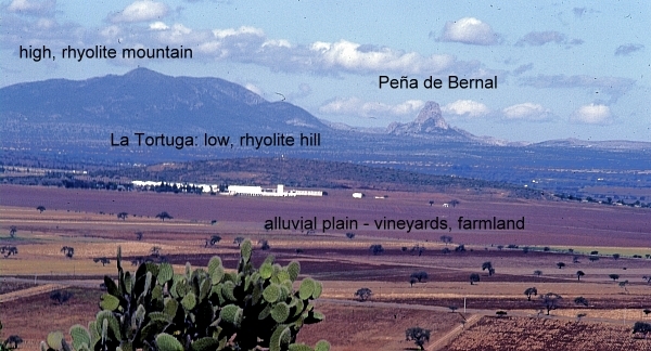
The fieldwork starts with a fieldsketch from near Tequisquiapan. Any suitable vantage point will do, provided it offers a clear view northwards to the very distinctive Peña de Bernal (seen in the background of the photo below). At this point, a simple line sketch should suffice to help students identify the following four different kinds of terrain:

  • flat or gently sloping plain, used for cultivation
  • low hills, with gently sloping sides, which look to be covered in bushes and cacti [scrub vegetation]
  • high mountains, with steeper slopes, also with no obvious signs of cultivation
  • the Peña de Bernal itself, a distinctive monolith with exceptionally steep sides

There is no need to identify any rocks or use any geological terms (students can add appropriate labels later!). Engage the students in a discussion about why there might be four different kinds of relief visible in this area, and how their ideas or hypotheses could be investigated further. Conclude the discussion by explaining that they are now going to look for evidence related to the idea that these four different kinds of relief are connected to significant differences in geology.

View looking north from "Las Cruces" near Tequisquiapan. Photo: Tony Burton; all rights reserved.

View looking north from "Las Cruces" near Tequisquiapan. Photo: Tony Burton; all rights reserved.

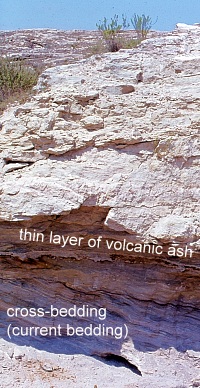
The next stop is a small roadside quarry on the flat area. The most accessible quarry many years ago was located a short distance south of Tequisquiapan on the east side of the highway, but any quarry on the flat land will serve to reveal the rocks that form the plain.

Roadside quarry, near Tequisquiapan. Photo: Tony Burton; all rights reserved

Roadside quarry, near Tequisquiapan. Photo: Tony Burton; all rights reserved

[Warning: Ensure that you park off the highway; when examining the rock in the quarry, avoid any overhanging sections, and do not do anything to cause slope instability or collapse].

The rocks in the quarry are in layers (sedimentary) and very distinctive. The individual particles of the rock are rough to the touch and sand-sized, so this is some kind of sandstone.

Some layers are more or less horizontal, but in places successive layers are laid down at a much steeper angle. This is “current bedding” and indicates that the rocks were formed by water, perhaps where a river entered a lake. The individual particles in the rock are not well-rounded, so have not traveled all that far.

Within each major layer, the material shows signs of sorting, with fine material sitting on top of coarse material. In some places, the sandstone contains small pebbles, so this rock is a sandstone conglomerate. Small casts of fossil shells can be seen in places, further suggesting it is a sedimentary rock deposited in a former lake.

A very thin white layer is present (at about head height in the photo). This layer is totally different to the sandstone conglomerate. It is fine material that has been compacted. Given the volcanic history of central Mexico, this is almost certainly a thin layer of volcanic ash that covered older rocks before being covered in turn by the next layer of sediments.

With some guidance, students should be able to work most of this out for themselves! The last stage at this stop is to ask why this rock forms the flat land in the area, rather than the hills. (Answer: softer, weaker, less resistant, easier to erode, etc).

The next stop is to take a look at the rock forming the low hills. The highway between Tequisquiapan and Ezequiel Montes (see map) conveniently cuts through a low ridge at San Agustín. This affords an opportunity to take a close look at the rock forming that ridge. [Warning: Ensure that you find a safe parking spot, and take every precaution, since traffic along this highway can be heavy and very fast-moving]

The rock at San Agustín is darker and much harder than the rock in the quarry. It has clear crystals in it, apparently arranged haphazardly. From its color (grey) and grainsize (fine), it is a rhyolite [a fine grained, acid igneous rock].  It is far more difficult to erode than the sandstone on the plain, so it forms upstanding ridges and low hills in the landscape.

From San Agustín, drive through Ezequiel Montes and on to the town of Bernal, one of Mexico’s “Magic Towns“. The next part is the most physically-challenging part of the excursion since it is necessary to climb at least part-way up the Peña de Bernal! [Warning: this is very steep in places, and climbing beyond the mid-way “chapel” is definitely not recommended]. Examining the rocks of the Peña de Bernal reveals that they are lighter in color than the rhyolite and fine-grained, but with larger crystals (phenocrysts) in some places. This rock must have cooled very slowly (or the phenocrysts would not have had chance to form) and this is an intrusive igneous rock known as microgranite. Eagle-eyed students should also find some other rocks while climbing the Peña de Bernal. In places, it is possible to find good specimens of a very hard, banded metamorphic rock that was formed when heat and/or pressure transformed pre-existing rocks. The banded rock is a gneiss [pronounced “nice”].

The presence of intrusive igneous rocks (formed underground) together with metamorphic rocks strongly suggest that the Peña de Bernal is an example of a volcanic plug. It represents the central part (and all that now remains) of a former volcano, whose sides, presumably composed of ashes and lava, have long since eroded away.

Conclusion:

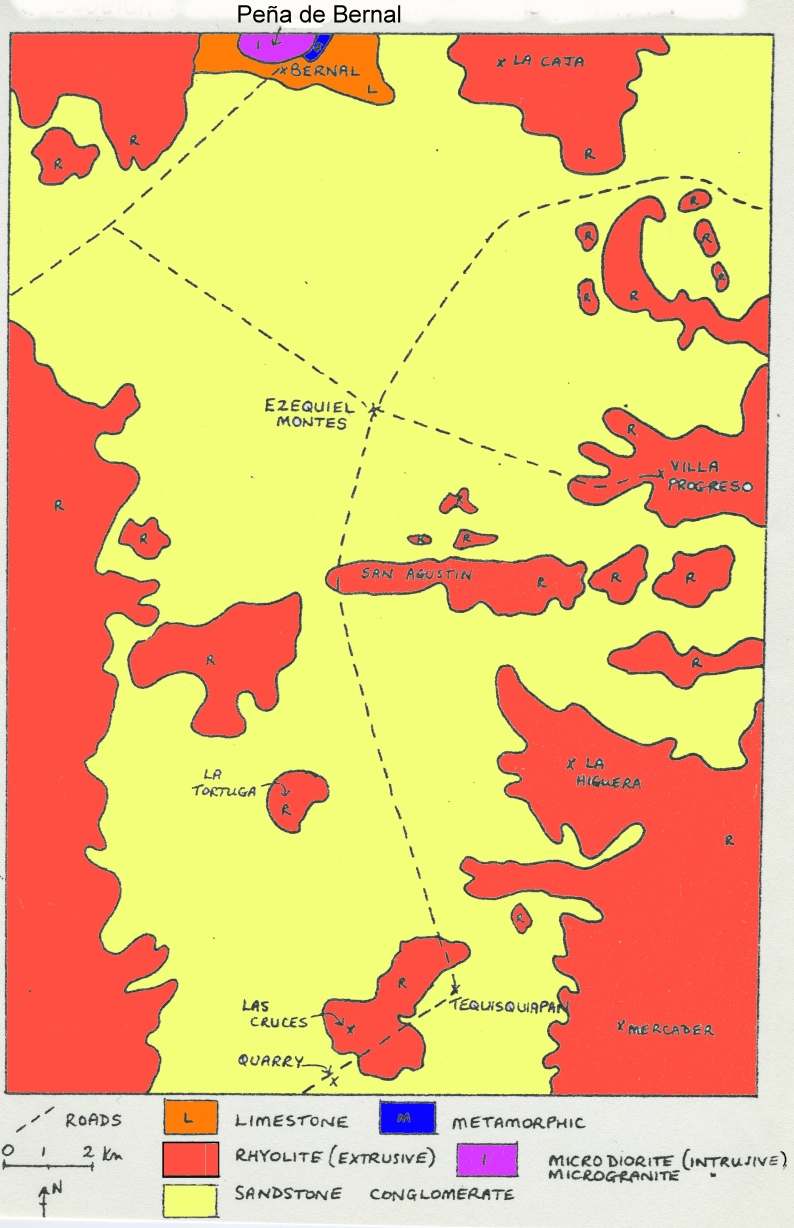
After students have had chance to work most of this out for themselves, a look at the local geological map should confirm that their deductions are reasonable. As can be seen on the map below, the flat area is indeed an alluvial plain (sandstone), with low rhyolite hills and ridges in places, and higher rhyolite mountains in the background, with the distinctive Peña de Bernal made of igneous and metamorphic rocks at the northern edge of the map.

In this particular part of Mexico, as in many other areas, the link between geology and relief is very strong! Happy exploring!

Sketch map, Geology of the Tequisquiapan area

Sketch map, Geology of the Tequisquiapan area; click to enlarge

Related posts:

Jun 072012
 

The Peña de Bernal, in the central state of Querétaro, is one of Mexico’s most distinctive geomorphosites. Geomorphosites are “landforms that have acquired a scientific, cultural/historical, aesthetic and/or social/economic value due to human perception or exploitation” (Panizza M., 2001). See Geotourism and geomorphosites in Mexico for a brief introduction to the topic.

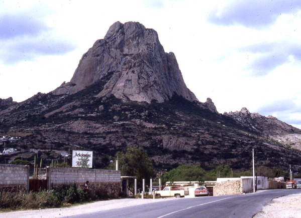
The Peña de Bernal is a dramatic sight, which only gets more imposing the closer you get. How high is the Peña de Bernal? We are unable to give you a definitive answer (it depends where you start measuring from) but claims of 350 meters (1150 feet) sound about right, assuming we start from the town.

Peña de Bernal. Photo: Tony Burton; all rights reserved

The Peña de Bernal. Photo: Tony Burton; all rights reserved.

According to its Wikipedia entry, this is the “third tallest monolith in the world”, apparently only exceeded by the Rock of Gibralter and Sugarloaf Mountain in Rio de Janeiro. Others, including Melville King, have described it as the “third largest rock in the world”. These claims may (or may not) be exaggerated, but in reality it is definitely a very steep and tiring climb, even to reach the small chapel that has been built half-way up! The photo below is taken from this chapel, looking out over Bernal and the local farmland and vineyards.

View from the Peña Bernal, with the town of Bernal in the foreground.

View from the Peña de Bernal over the small town of Bernal. Photo: Tony Burton; all rights reserved.

How was the Peña de Bernal formed?

The most likely explanation is that this monolith represents the hardened magma (molten rock) from the central vent of a former volcano. This rock was much more resistant to erosion that the layers of ash and/or lava that formed the volcano’s flanks. Centuries of erosion removed the sides, leaving the resistant core of the volcano exposed as a volcanic neck. We will examine this idea in slightly more detail in a future post.

The town of Bernal

The town of San Sebastián Bernal is also well worth visiting. Having become a magnet for New Age types, it now boasts several decent restaurants, good stores and a range of hotels including high quality “boutique” hotels. Bernal was designated one of Mexico’s “Magic Towns” in 2005. To learn more about the town of Bernal and see some fine photos, we highly recommend Jane Ammeson’s article “The magic of Bernal, Querétaro: wine, opals and historic charm.

At the Spring Equinox (March 21), the town is invaded by visitors “dressed in long, white robes or gowns, and red neckerchiefs” who come seeking “wisdom, unity, energy and new beginnings”. (Loretta Scott Miller writing in El Ojo del Lago, July 1997).

How to get there:

From Mexico City, take the Querétaro highway (Hwy 57D) north-west to San Juan del Río. Then take Highway 120 past Tequisquiapan as far as the small cross-roads town of Ezequiel Montes. Turn left for about 11 kilometers, then right… and you’re there! Taking this route gives you glimpses of the Peña de Bernal from afar. Allow 2.0 to 2.5 hours for the drive.

Other geomorphosites worth visiting:

Mexico has literally thousands of geomorphosites. Among those described in previous posts are:


Oct 062011
 

The small town of Tequila, the center of production of Mexico’s national drink, lies in the shadow of an imposing 2700-meter (8860-ft) volcano. Most visitors to the town visit the National Tequila Museum, take a distillery tour, and then sample one or two of the many world-famous brands of tequila made in the area.

The spine of Tequila Volcano

The spine of Tequila Volcano. Drawing by Mark Eager (Western Mexico, A Traveler’s Treasury); all rights reserved.

Tequila Volcano, which overlooks the rolling fields of blue agaves required to make the liquor, is the home of one of Mexico’s most distinctive geomorphosites. From the rim of its crater, the most arresting thing about the view is not the green, tree-covered crater itself but the giant monolith with almost vertical sides rising perpendicularly from the middle of the crater floor.

This well-preserved central spine, known locally as la tetilla (“the nipple”) is quite unusual. It represents the hardened lava which cooled in the central vent of the volcano and which, solid and unyielding, was later pushed upwards by tremendous subterranean pressure.

Few such good examples exist anywhere in the world. The example most often quoted in geography texts is the spine that was pushed up by Mont Pelée on the island of Martinique in the West Indies in October 1902, immediately prior to that volcano’s disastrous eruption which cost 32,000 lives.

How to get there

A cobblestone road begins near the railway station in the town of Tequila and winds up Tequila Volcano towards the short-wave communications tower on its rim. It is about 20 kilometers from the town to the rim. The hike or drive up to the rim affords glorious views over the surrounding countryside. As you gain altitude, so the vegetation changes, becoming luxuriant pine-oak forest well before you reach the rim. Looking across the crater, on a day when clouds slowly drift across and partially obscure the view, is like watching a silent movie of ancient Chinese landscape drawings.

Want to read more?

For a fuller description of a visit to Tequila Volcano and a climb up the volcanic spine, see John and Susy Pint’s Outdoors in Western Mexico (2nd edition 2011).

For a description of Tequila Volcano and the varied villages and sights in its vicinity, see chapters 9 and 10 of my “Western Mexico: A Traveler’s Treasury” (Sombrero Books, 2013), also available in a Kindle edition.

Mexico’s geomorphosites: The Piedras Bola (Stone Balls) of the Sierra de Ameca, Jalisco

 Other  Comments Off on Mexico’s geomorphosites: The Piedras Bola (Stone Balls) of the Sierra de Ameca, Jalisco
Sep 272011
 

The Sierra de Ameca is a range of hills a short distance west of Guadalajara. The area was important in colonial times for gold and silver mining. One of the mines is called Piedra Bola (Stone Ball). The landscape immediately around this mine is so distinctive and unusual that it featured on the cover of the August 1969 edition of National Geographic.

In the middle of the forest surrounding the Piedra Bola mine are about a hundred strange stone balls. They are almost perfectly spherical and range in diameter from about sixty centimeters to more than ten meters. These symmetrical boulders are unusually large. Nothing quite like them exists elsewhere in Mexico and few similar examples are known anywhere in the world.

Piedras Bola

Piedras Bola

Some are buried, others partly or fully exposed. In some places, erosion of the surrounding rocks has left a sphere perched precariously atop narrow columns of softer rock, seemingly ready to topple in the next strong wind. These “hoodoos” or earth pillars have been formed as a result of water erosion and they may survive for centuries until the processes of sub-aerial weathering and erosion finally cause them to fall.

Piedra Bola atop an earth pillar

Piedra Bola atop an earth pillar

How were the Piedras Bola formed?

This summary of the most likely explanation of the origin of the stone spheres is based on that offered by Dr. Robert Smith of the U.S. Geological Survey in the original National Geographic article.

During the Tertiary geological era, 10-12 million years ago, a local volcano erupted, causing a deluge of glassy fragments of molten lava and ash, together with large quantities of volcanic gas trapped in the mixture. The mixture was very hot, probably between 550 and 800̊C. The deluge of material partially filled an existing valley, burying the former surface.

As the mixture cooled down, the existing glassy fragments formed nuclei around which much of the remainder of the material crystallized. Spherical balls began to form, their size depending on how long the crystallization process continued uninterrupted. The longer the time, the bigger the ball…. The most perfect balls were formed near the previous ground level, inside the hot mass of ashes, where the cooling would have occurred more evenly than in the bulk of the matrix material. The crystallized material is a kind of rhyolite which has an identical chemical composition to the fragments of glassy obsidian also found in the area.

The remainder of the ashes cooled down and became a consolidated accumulation of ashes and glassy fragments or tuff, without clearly defined spheres. This tuff is weaker, and has a lower density than the stone balls within it. During succeeding millenia, the combined processes of physical and chemical weathering weakened the surrounding tuff, and water (rain and rivulets) then eroded away this loose material, exposing some of the rhyolitic boulders completely and others partially.  As these processes continue, so more of the boulders will be exhumed from beneath their cover of tuff, and be revealed to us.

Protected?

The Jalisco State government has developed a small park around the Piedras Bola, including decent trails, some signposts and an amphitheater. There are even (reportedly) two ziplines, though I haven’t yet had the dubious pleasure of seeing them for myself. Increasing the number of visitors to  geomorphosites is not a bad idea, but some basic education and protection is needed if these and other geomorphological sites are going to be preserved intact for future generations. In the case of the Piedras Bola, graffiti now mar many of the exposed stone spheres and some of the spheres have been dynamited, apparently in the mistaken belief that the center of the sphere contained gold.

picture of piedras bolaHow to get there:

The entrance road to the Piedras Bola (formerly only a hiking trail) begins from km. 13 of the paved road that crosses the mountains from Ahualulco to Ameca. For anyone who does not have time for the hike, but still wants to see what these extraordinary stone spheres look like, the locals have thoughtfully rolled one down the mountain and onto Ahualulco’s main plaza.

Want to read more?

For more images and details, see John Pint’s article, Las Piedras Bola: the great stone balls of Ahualulco, on MexConnect, together with his outstanding gallery of photos.

Sep 082011
 

Geotourism is geography tourism (as opposed to tourism geography!). It applies to any recreational (tourism) activity where one of the primary objectives is to visit some phenomenon of geographic importance. This could be a coral reef, mangrove swamp, volcano, mountain peak, cave or canyon, but it could just as easily be a sinkhole, waterfall, new town or sugar mill. Ideally, geotourism should be sustainable, ecologically-aware and culturally-sensitive.

Geotourism often involves visiting landforms that hold special value: geomorphosites. Mexico has an amazing diversity of geomorphosites, quite possibly the richest collection of any country in the world.

What exactly are geomorphosites?

Geomorphosites were first defined in 1993 by Mario Panniza. Essentially, they are landforms that have acquired, over time, a certain value. Once noticed and made accessible to people, the landforms acquire scientific, cultural, historical, aesthetic, and socio-economic value. [1]

Panniza subsequently defined geomorphosites as,”landforms that have acquired a scientific, cultural/historical, aesthetic and/or social/economic value due to human perception or exploitation.” [2]

Reynard and Panniza state that geomorphosites can vary in scale from a single geomorphological object (eg a sink hole) to a wider landscape (eg a mountain range) and that geomorphosites “may be modified, damaged, and even destroyed by the impacts of human activities.” [3]

The marine arch at Cabo San Lucas, an example of a geomorphosite

The marine arch at Cabo San Lucas, an example of a geomorphosite

The dominant additional value may be economic, ecological, aesthetic or cultural, and this provides a starting point for assessing whether or not a particular landform is a geomorphosite or not.

The science study (see first comment below!) of geomorphosites is still in its infancy. Several competing classifications have been proposed, and no definitive consensus has yet been reached on the best way to quantify the value of a particular example.

One set of criteria for assessing geomorphosites includes:

A. Economic value:

  • accessibility,
  • number of visitors,
  • inclusion in promotional literature

B. Scientific/ecological value:

  • palaeogeographical interest,
  • singularity,
  • integrity (state of conservation)
  • ecological interest

C. Aesthetic value:

  • the number and spacing of belvedere points (high points from which a view is possible over the surrounding landscape)
  • shape
  • altitude
  • color

D. Cultural value:

  • cultural legacy (writing, art etc),
  • historical and archaeological significance,
  • religious relevance,
  • artistic and cultural events

Mexico has literally thousands of geomorphosites. We have already described some of them, including:

and we plan to highlight many more in future posts, including:

  • Piedras Bola (Stone Balls) in Jalisco
  • Peña de Bernal, a monolith in Querétaro
  • Sumidero Canyon in Chiapas
  • the iconic marine-eroded arch at Cabo San Lucas (see photo)

The scientific study of geomorphosites should enable researchers to suggest ways to approach their management. Unlimited access to some geomorphosites may generate a healthy flow of admission fees but could also easily increase erosion and hasten the destruction of the very thing that the tourists are paying to see.

On your next trip to Mexico, make sure to visit one or more of the country’s super-numerous geomorphosites!

References:

[1] Comanescu and Nedelea, Area (2010) 42:4, 406-416.

[2] Panizza M. (2001) Geomorphosites : concepts, methods and example of geomorphological survey. Chinese Science Bulletin, 46: 4-6

[3] Reynard, E and Panizza, M. (2005 ) Geomorphosites: definition, assessment and mapping, Géomorphologie : relief, processus, environnement , 3/2005

Jun 092011
 

Peculiar, but true. There are several lakes named Laguna Encantada (Enchanted Lake) in Mexico, but this one is near Catemaco in the Tuxtlas region of the state of Veracruz. Catemaco is famous for its witches, so perhaps one of them cast a spell on the lake, making it behave perversely, its level changing in opposition to all the other lakes in the country?

Laguna Encantada

Laguna Encantada, Veracruz. Photo credit: Hector Reyes

Occupying the crater of an extinct volcano, La Laguna Encantada is a truly beautiful lake, especially near sunrise or sunset. Laguna Encantada is located 3 km northeast of San Andrés Tuxtla. The access road is unpaved. The views are ever-changing on the easy walk of about 1500 meters (slightly under one mile) around its shoreline. As you walk, try counting the butterflies. A study twenty years ago recorded a staggering total of 182 different species in this relatively small area of jungle.

The lake nestles on the southern flank of the San Martín volcano. This dormant volcano is a prominent landmark north-west of Lake Catemaco close to San Andrés Tuxtla. Its crater, 1500 meters across, is at a height of about 1400 meters above sea level, and has two small subsidiary cones inside it.

The basaltic lavas and layers of ash forming the volcano are highly permeable and porous. As a result, despite the heavy rainfall, there are no permanent streams flowing down the upper slopes.

Some distance away from the volcano, though, there are several good-sized lakes including Catemaco and Laguna Encantada. Catemaco is large enough to capture plenty of rainfall to maintain its level. The much smaller basin holding Laguna Encantada (350 meters above sea level), however, does not receive sufficient rain to keep its level high.

Instead, and this is the wonder of La Laguna Encantada, much of its water supply comes from underground. Water that falls on the slopes of the San Martín volcano during the rainy season soaks into the ground and then percolates slowly towards the lake, so slowly that it takes six months to reach it. The result? The lake is unable to sustain its level during the rainy season, but the underground water reaching it in the dry season is more than sufficient to replenish its level. Maybe the witches of Catemaco have something to do with it, but hydrology also plays a part!

Eyipantla Falls

Eyipantla Falls Photo: Tony Burton

Salto de Eyipantla

Only a few kilometers from Laguna Encantada is another wonderful natural sight: the Eyipantla Waterfall (Salto de Eyipantla). The water for the falls comes from the Comoapan river, which drains Lake Catemaco. After heavy rain, the curtain of water at Eyipantla is about 50 meters high and 20 meters wide. The sunlight playing on the water creates a dazzling display of magical colors. The Tuxtlas region has been the setting for numerous movies and commercials and the impressive Eyipantla Falls have starred in many of them. The unusual name, Eyipantla, reflects its three chutes of water, and is derived from the Nahuátl words, eyi (three), pantli (trench) and tla (water).

Chapter 4 of Geo-Mexico: the geography and dynamics of modern Mexico discusses Mexico’s diverse climates.  Chapter 5 focuses on ecosystems and biodiversity.  Chapter 30 analyzes environmental issues and trends including the impact of Old World species imported by the Spaniards, current environmental threats, and efforts to protect the environment.  Buy your copy today to have a handy reference guide to all major aspects of Mexico’s geography!

How were the Piedras Encimadas (Stacked Rocks) in Puebla, Mexico, formed?

 Other  Comments Off on How were the Piedras Encimadas (Stacked Rocks) in Puebla, Mexico, formed?
Jun 072011
 

The Valle de las Piedras Encimadas (Valley of the Stacked Rocks) is 150 km from the city of Puebla in the northern part of the eponymous state. The Piedras Encimadas are rock outcrops occupying an area of about 4 square km (990 acres) centered on a small valley at an altitude of 2400 meters above sea level. The dominant natural vegetation is pine-oak forest. The main natural attraction of the area are the numerous, fascinating and photogenic”stacked rock” formations.

Piedras Encimadas, Zacatlán
Piedras Encimadas, Zacatlán, Sierra Norte, Puebla

The stacked rocks of the Piedras Encimadas can easily be likened to people (soldiers, sentries) and animals (dinosaurs, elephants, turtles), depending on the sensibilities of the observer. The shapes appear even more “fantastic” on the frequent occasions when clouds roll into the valley, enveloping the rocks in a thin mist.

According to geography researchers from the National University (UNAM), the volcanic rocks (rhyolites and andesites) forming the Piedras Encimadas date from the Tertiary period (60 million years BP).

The Piedras Encimadas look very similar to the much-studied granite “tors” found in the UK and elsewhere. Indeed, they may even have been formed in a similar way. However, geologists still debate precisely how tors were formed, and their uncertainties almost certainly apply equally to the Piedras Encimadas.

  • Theories for the formation of tors on Dartmoor, UK

Most theories of tor formation (see link)  involve the concept of “differential weathering”. This occurs when some parts of an area weather (disintegrate) more rapidly than others. Differences in weathering rates result from a variety of reasons, including differences in rock types and resistance within the same rock type, as well as localized changes in the climate, vegetation cover, aspect (direction the slope faces), altitude or exposure to air or water.

Tor formation (after Linton).
Tor formation (after Linton). Fig 3.5 of B.W. Sparks: Rocks and Relief (1971)

Over a long period of time, the weaker parts of the rock may have been weathered to greater depths than the more resistant parts. If subsequent erosion, most likely by river action in the context of Puebla, stripped away all the weathered rock, it would leave the more resistant rock as upstanding craggy outcrops (see sequence diagram above)

The shape of many of the blocks of rock forming the Piedras Encimadas does suggest that they were originally weathered deep underground from chemical reactions they underwent as water percolated slowly down towards the water table. Such a process would have acted more on the upper faces of each block, rather than the lower faces, producing a block that was rounded above, and almost flat below.

If the blocks had been modified by erosion (the other major possible interpretation), then it is more likely that both the upper and lower faces of each block would be equally rounded or that the lower face would be more eroded than the upper face.

Regardless of the details, it is almost certain that the curiously-shaped Piedras Encimadas were formed by a combination of volcanic action, differential weathering and erosion. The Piedras Encimadas offer lots of interesting possibilities for geography fieldwork.

Related posts:

How did the world’s deepest water-filled sinkhole form?

 Updates to Geo-Mexico  Comments Off on How did the world’s deepest water-filled sinkhole form?
Oct 112010
 

In an earlier post, we described the El Zacatón sinkhole, the deepest water-filled sinkhole known at present anywhere on the planet. Such a large sinkhole begs some important questions:

How did such a large sinkhole form?

Most major sinkholes form as a result of the collapse of the ceilings of underground cavities which have been formed by the gradual dissolution of limestone due to percolating acidic rainwater. However, according to Marcus Gary, of the Jackson School of Geosciences at the University of Texas at Austin, who has studied this area since the 1990s, the Zacatón pit is not a conventional sinkhole. He believes that this pit began to form in the Pleistocene period as a result of underground volcanic activity. Volcanism increased the acidity of water deep underground which then gradually ate away at the surrounding limestone in a process known as “hypogenic karstification“. As the underground caverns grew larger, the overlying rock would periodically collapse into them, eventually leaving giant pits extending to the surface above.

Is the sinkhole continuing to get deeper?

Equally interestingly, some of the sinkholes appear to be closing over. All the major sinkholes in Tamaulipas contain lakes and in several cases, they appear to be crusting over with travertine, a form of calcium carbonate which, in the right conditions, can be precipitated out of calcium bicarbonate-rich water. According to Marc Airhart, another researcher at the Jackson School of Geosciences, the process is probably an excruciatingly slow one, but at least one sinkhole (Poza Seca) has closed up entirely, sealing off an underwater lake. This travertine skin may also explain why El Zacatón has floating islands. It seems likely that pioneer species may have colonized small rafts of travertine, beginning the series of ecological processes that resulted in the grassy islands that can be seen there today.

Sources / Further reading:

Mexico’s geology and landforms are analyzed in chapters 2 and 3 of Geo-Mexico: the geography and dynamics of modern Mexico.  Buy your copy of this book today!

The geography of Mexico’s caves

 Mexico's geography in the Press  Comments Off on The geography of Mexico’s caves
Oct 022010
 

For a fascinating overview of caves and caving in Mexico, see John Pint’s great article and image gallery (link below) on MexConnect. Pint is an accomplished caver and author who has explored caves on several continents. His writing is clear and authoritative, much of it based on his own first-hand experiences and investigations.

Caves have played an important part in Mexico’s history. The Maya on Mexico’s Yucatán Peninsula, which is largely limestone, and now known to be riddled by amazing interconnected sinkholes and subterranean tunnels, viewed caves as entrances to an underworld. They revered some caves in particular, adorning them with lavish offerings.

Cacahuamilpa cave

The sinkholes of the Yucatán Peninsula are beautiful, but are not all that deep. In the state of Tamaulipas, El Zacatón is a sinkhole that is considered the deepest water-filled sinkhole in the world.

In the early days of tourism in Mexico, the Cacahuamilpa Caverns near Taxco (Guerrero) were a popular place to visit. The English traveler Mrs. Alec Tweedie recalls in Mexico as I saw it how she was deep underground in these caves when a telegram arrived bearing the sad news that Queen Victoria had passed away. (If only postal and telegraph services were that efficient today!)

In recent years, scientists have begun to unravel the mysteries of how strange forms of life can thrive deep underground, even in environments that are noxious to humans. The sulfur-loving organisms of the Cueva de la Villa Luz in the state of Tabasco are a much-studied example.

Pint also discusses lava caves, of which Mexico has some fine examples. One of the most visited lava caves in the world must be that which plays home to the La Gruta restaurant, close to the famous archaeological site of Teotihuacan.

And, finally, for one of the most spectacular caves imaginable, how about the Naica crystal caves?

Visit John Pint’s website for a selection of his writing, with many original articles, illustrated with great photographs, about individual caves in Mexico.

Sadly, we did not have room in Geo-Mexico: the geography and dynamics of modern Mexico to delve beneath the surface into the wonders of Mexico’s caves.  Mexico’s landforms are discussed in chapter 3, which may be expanded in future editions, depending on the feedback from readers like you. If you have not yet read a copy, please ask your local library for a copy, or better yet, please consider purchaing your own copy via this website or amazon.com

Feedback from readers about any aspect of Geo-Mexico: the geography and dynamics of modern Mexico is welcomed.

Mexico’s Copper Canyon is one of the world’s most amazing natural wonders

 Excerpts from Geo-Mexico, Updates to Geo-Mexico  Comments Off on Mexico’s Copper Canyon is one of the world’s most amazing natural wonders
Aug 282010
 

The Copper Canyon, one of Mexico’s most amazing natural wonders The rugged ranges of the Western Sierra Madre in the state of Chihuahua conceal several massive canyons, giving rise to incomparable scenery. The Copper Canyon (Cañon del Cobre) region is the collective name given to this branching network of canyons, larger in many respects (see table) than the USA’s Grand Canyon.

How does Mexico’s Copper Canyon compare to the US Grand Canyon?

Urique CanyonsUS Grand Canyon
Total length of rivers (km)540446
Depth (m)1250–18701480
Altitude of rim (m above sea level)2250–25402000–2760
Maximum width (km)415

Strictly speaking, the name Copper Canyon refers only to one small part of the extensive network of canyons which is more properly called by geographers the Urique Canyon system. As the table shows, the Urique Canyons are longer, deeper and narrower than their US rival.

Mexico's Copper Canyon

How was the Copper Canyon formed?

According to a local Tarahumara Indian legend, the canyons were formed when “a giant walked around and the ground cracked.” Geologists believe that a sequence of volcanic rocks varying in age from 30 to 135 million years were slowly uplifted to an average elevation of 2275 m (7500 ft) and then dissected by pre-existing rivers.

These antecedent rivers retained their courses, cutting down over 1400 m into the plateau surface, forming deep canyons and dividing the former continuous plateau into separate giant blocks. Centuries of erosion by the Urique river and its tributaries have resulted in the present-day landscape of structurally-guided plateau remnants, termed mesas, buttes and pinnacles, depending on their size.

The mud volcanoes known as Los Negritos, in Michoacán, Mexico

 Other  Comments Off on The mud volcanoes known as Los Negritos, in Michoacán, Mexico
May 112010
 

Los Negritos (the Little Black Ones) are a legacy of the volcanic heritage of most of central and western Mexico. They are located a few kilometers east of Jiquilpan in the state of Michoacán.

Two of the “Los Negritos” mud volcanoes. Photo: Tony Burton. All rights reserved.

Los Negritos are small mud volcanoes (up to a meter or two across) which burble and gurgle, hiss and splutter, and occasionally erupt, throwing hot mud into the air and emitting sulfurous fumes. They are great fun to watch, but take care! Don̓t get too close or you may be splattered with the hot mud. Worse yet, you could step in the innocuous-looking but highly unstable surrounding mud patches which can rarely hold a person’s weight.

Other vestiges of volcanic action include several geysers, including the one at Ixtlán de los Hervores and the many thermal hot springs, now often utilized for tourist facilities and spas, scattered  throughout Mexico’s Volcanic Axis.

This is an edited extract from Western Mexico, A Traveler’s Treasury (Sombrero Books 2013).

Mexico’s volcanic landscapes are discussed in chapters 2 and 3 of Geo-Mexico: the geography and dynamics of modern Mexico.

Mud volcano puffs into action. Photo: Tony Burton. All rights reserved.

May 072010
 

The geysers of Ixtlán de los Hervores have long attracted the attention of travelers. They are located north-west of the city of Zamora in the state of Michoacán. The temperature of the water emerging from underground varies between about 90 and 100 degrees Centigrade.

Here is how English explorer Captain George Lyon described them following his visit in 1826:

Photo: Tony Burton. All rights reserved.

”The plain is interesting, as being in some places covered by an efflorescence of muriate of soda, which forms a considerable article of commerce. The saline earth is collected into large vats, through which water is filtered, and then placed to evaporate in small well-cemented beds of about twelve feet by six. All this, however, interested me but little in comparison with the wells of boiling water, which to the amount of many hundreds are dispersed in a space of one mile and a half by a quarter of a mile in width, east and west along the plain, and sending up at intervals clouds of steam. In fact the whole surface of this place is nothing more than the crust of a volcano; and seven years back an earthquake opened a large rent in the plain,whence issued  fountains of the purest water, and of mud also, both of a boiling heat.

In the evening I rambled amongst the springs, which are of all forms and sizes, from holes not larger than an inch, through which the water is seen and heard boiling beneath, to large spaces of several yards in diameter; some as transparent as though distilled. Others, within a foot of them are turbid, or of boiling mud; and there is one called “El Pozo Verde,” in which, although perfectly clear, the water is of a fine deep green. The springs are in some places constantly tranquil, and varying in temperature  from 110̊ to 130̊; but in far the greater number the water boils up with amazing force and in one well, chosen at random, I cooked a piece of mutton of the size of an egg in four minutes and fifty seconds. All the fountains which have been sufficiently small to admit of it, have been choked up with stones and bushes, to prevent cattle from falling into them; yet a number of poor beasts are frequently thus destroyed.”

Lyon, G.F. 1828 Journal of a residence and tour in the Republic of Mexico in the year 1826, with some account of the mines of that country. London: John Murray.

Mexico’s volcanic landscapes are discussed in chapters 2 and 3 of Geo-Mexico: the geography and dynamics of modern Mexico.

Apr 012010
 

The map shows the state of Chihuahua in northern Mexico. The state capital is the city of Chihuahua (2009 population: 839,000) . Chihuahua is the largest state in Mexico in area: 247,087 square kilometers  (95,401 square miles). The state’s population is 3,422,047 (CONAPO 2010 estimate).

Cd. Juárez is the state’s largest city and Mexico’s 8th largest city with a population of about 1.4 million. In recent years, the city, across the border from the US city of El Paso, has gained considerable notoriety on account of its violence and high murder rate. It also faces air pollution issues, discussed in chapter 23 of Geo-Mexico: the geography and dynamics of modern Mexico.

Map of Chihuahua. Copyright 2004, 2010 Tony Burton. All rights reserved.

The state of Chihuahua has several important tourist attractions, including:

  • the Copper Canyon region (narrower, deeper and longer than the US Grand Canyon) which is home to the Tarahumar Indians, an indigenous group with a particularly distinctive lifestyle. The Copper Canyon and Tarahumar Indians are discussed in chapters 13, 17 and 19 of Geo-Mexico. A world-famous tourist train traverses this region.
  • Mexico’s two highest waterfalls, the Piedra Volada Falls, where the water tumbles 453 meters (1,486 feet) and the Basaseachic Falls, which are  246 meters  (807 feet) in height. The Piedra Volada Falls, which are seasonal, are not shown on this map, but are a short distance north of the Basaseachic Falls.
  • The Casas Grandes area with its important archaeological site
  • Mennonite farming areas; their distinctive landscapes are discussed in chapter 11 of Geo-Mexico
  • Many sites associated with famous revolutionary figure Pancho Villa, including his former 50-room mansion, now a museum, in the state capital

Click here for the interactive version of this map on MexConnect website.