Feb 122017
 

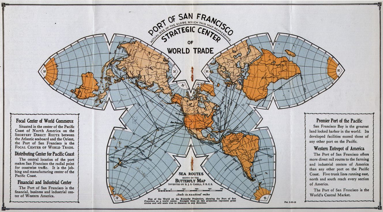
One of the more beautiful, unusual and useful map projections ever devised was created by cartographer Bernard Cahill. The butterfly projection was first published in the Scottish Geographical Magazine in 1909. Cahill (1866-1944) later applied for a US patent to protect his creation.


I first came across Cahill’s projection on a stamp issued in Mexico in 1964. The design of the stamp (see image) shows his world map, an octahedral whose eight faces have been flattened into a shape resembling a butterfly. Ever since then I have wondered why such an unusual map would be chosen for a Mexican stamp that commemorated the 10th Conference of the International Bar Association (IBA), held that year in Mexico City. Coming some 20 years after the cartographer’s death, it seems an unlikely choice. So far, all my efforts to find a link between Cahill, the IBA and Mexico have drawn a blank. (Note to readers: Help needed!)

Cahill’s butterfly map, like Buckminster Fuller’s later Dymaxion Maps (1943 and 1954) enabled all the continents to appear linked, and with reasonable fidelity to a globe. Cahill demonstrated this principle by also inventing a rubber ball globe which could be placed under a pane of glass and flattened into the “Butterfly” form. When removed, the map/globe reverted to its original shape.

The original Cahill projection (1909). Credit: Gene Keyes

The original Cahill projection (1909). Credit: Gene Keyes

Largely in honor of his cartographic innovation, Cahill was elected a Fellow of the Royal Geographical Society. In 1913 he started the Cahill World Map Company, but this company was not successful and his map has since been largely forgotten by most people.

But not by cartographer Gene Keyes! Except for Cahill himself, no follower of Cahill’s projection has ever been as dedicated as Gene Keyes, a former student of Buckminster Fuller. Keyes’ website is a mine of information about Cahill and his map projection, and is well worth reading.

Born in the UK, Bernard Joseph Stanislaus Cahill (18661944) was an architect, town planner and cartographer who moved to San Francisco, California, in 1888. He was an early proponent of the San Francisco Civic Center and designed that city’s Neptune Society Columbarium.

Cahill encountered some stiff obstacles in the many years it took him to develop his butterfly projection. For example, he lost all his initial drawings and papers in the disastrous San Francisco earthquake and fire of 1906. At least one major publisher signed a contract to publish the butterfly map as a wall map and in an atlas, but then failed to follow through.

Cahill’s world map used for world tours

Soon after its creation, Cahill’s butterfly map was used to illustrate a flying trip around the world, or circumaviation, proposed for the Panama Pacific International Exposition held in San Francisco in 1915. The map was exhibited at this exposition and won a gold medal for cartography. Some time later, the map was used by both the State of California and the City of Charleston to illustrate shipping routes.

In 1924, the American Express Company chose the map for use during a world tour aboard the Cunard ocean liner Laconia. According to Keyes, the map was prominently displayed on the Palm Deck of the ship and seen by Robert Ripley, a participant on the world tour, who later featured it in his Believe it or Not series.

Perhaps the closest Cahill came to seeing his map in more general use came in 1937, when the International Meteorological Committee apparently came within a single vote of adopting a version of his projection for all world weather charting.

No wonder, then, that in Keyes’ words, “Cahill should be seen in company with other pioneers such as Charles Babbage or Gregor Mendel, who died long before their efforts gained wider appreciation. As well, he antedates Buckminster Fuller, prophet of Spaceship Earth.”

Keyes goes on to note that, “Cahill was not merely an astute architect and cartographer, but, that like Fuller, his map expressed an underlying whole-earth philosophy much like themes which emerged 60 years later. Cahill used the term “geosophy” in that regard….” (And used it as early as 1912, well before the geographer J.K. Wright, commonly credited for having coined the term in 1947).

Will Cahill’s map ever catch on? The latest sign of renewed interest in Cahill’s projection comes from its adaptation by the New York Times as the basis for a series of 10 maps published in December 2011 illustrating the changing world of computing, communications and technology.

Keyes closes his account of Cahill’s map by quoting Ambrose Bierce, who in a letter to Cahill, wrote that, “The Butterfly Map is indubitably the right one, but it will be a long time before it gets into general use….”

Sadly, that has proved to be all too true, despite its inclusion in the design of a Mexican postage stamp.

Related posts using Mexican stamps for illustration:

Nov 012016
 

One of the earliest known maps engraved in colonial New Spain (Mexico) was that drawn by Antonio Ysarti in 1682. It shows the Franciscan Province of  San Diego of Mexico, with its 14 friaries, from Oaxaca in the southeast to Aguascalientes in the northwest. It covers the archdiocese of Mexico City, as well as the dioceses of  Puebla and Oaxaca to the east, and Michoacán and Guadalajara to the west.

Ysarti's 1682 map of New Spain

Ysarti’s 1682 map of New Spain; click map for an enlarged version of Mexico City to Acapulco

The beautifully-drawn map was originally published to illustrate Baltasar de Medina’s 1682 Chronica de la Santa Provincia de San Diego de Mexico, printed by Juan de Ribero. In the words of the sellers of this map’s original copper plate to the Library of Congress, “This artifact is tangible evidence of an emerging scientific and artistic community in a growing colonial empire.”

Sadly, very little is known about Antonio Ysarti, the map’s talented cartographer; not even his nationality is known for certain.

The map measures 29 x 19 cm approx (11.25 x 7.25 inches) and names more than 50 places. Each friary is depicted as an architecturally distinct building, not by the use of a common symbol.

Q. How well do you know central Mexico? Click on the map above (to reveal the section between Mexico City and Acapulco) and then see how many places you can identify and match to present-day place names.

Online version of this map, offering the ability to zoom in to specific parts

The changing political frontiers of Mexico are the subject of chapter 12 of Geo-Mexico: the geography and dynamics of modern Mexico, a handy reference guide to all aspects of Mexico’s geography. If you have enjoyed this post, please consider gifting a copy of Geo-Mexico to someone in the coming holiday season.

Alexander von Humboldt’s visit to Mexico, 1803-1804

 Other  Comments Off on Alexander von Humboldt’s visit to Mexico, 1803-1804
Sep 292016
 

Alexander von Humboldt‘s visit to Mexico began in Acapulco on March 22, 1803, and lasted for almost a year. (He left Mexico via Veracruz for the USA on March 7, 1804.) In his year in Mexico, Humboldt had been incredibly busy. He had measured, recorded, observed and written about anything and everything, with remarkable industry and accuracy. He had climbed mountains, burned his boots on active volcanoes, descended into mines, recorded geographical coordinates, and collected numerous specimens and antiquities. Humboldt’s Political Essay on the Kingdom of New Spain was the first systematic scientific description of the New World. It appeared in 1811, and marked the birth of modern geography in Mexico. His figures and ideas were used and quoted by writers for many many years.

Humboldt had also drawn a large number of maps, drawings and sketches and it can rightly be claimed that the modern era of Mexican map-making began with Alexander von Humboldt, and was then developed further later in the 19th century by cartographers such as Antonio García Cubas.

Humboldt's route in Mexico

Humboldt’s route in Mexico. Click to enlarge

Alexander von Humboldt (Self-portrait c1814)

Alexander von Humboldt (Self-portrait c1814)

The map above shows the route followed by Humboldt during his time in Mexico. The map comes from the book La obra de Alexander von Humboldt en México by Rayfred Lionel Stevens-Middleton  (Mexico D.F.: Instituto Panamericano de Geografía e Historía, 1956). This hard-to-find work is a comprehensive account of Humboldt’s time in Mexico and of his significance for the development of what the author refers to as “modern geography”.

The map of Humboldt’s route in Mexico includes his various side trips such as those to Jorullo Volcano and Santa María Regla.

Humboldt was keen to see Jorullo Volcano, since it was a rare example of a brand new volcano, one of only a handful of volcanoes that have emerged on land anywhere in the world in historic times. Jorullo first erupted on 29 September 1759 and activity continued for 15 years until 1774. Two centuries later, and about 80 km (50 miles) away, Paricutín Volcano burst into action for the first time, in a farmer’s field in 1943.

Santa María Regla, in the state of Hidalgo, about an hour’s drive north of Mexico City, is the best known location in Mexico for basalt columns. The columns, up to 40 meters tall,  are attractively located on the side of a canyon, with a waterfall tumbling over some of them:

Despite only seeing a relatively small part of the country (New Spain as it then was), Humboldt was able to make some generalizations about geography in general, and Mexican geography in particular, that have stood the test of time remarkably well. For example, he was the first to describe the vertical differentiation of climatic and vegetation zones in Mexico. Writing in 1811, he proposed the terms tierra caliente, tierra templada, and tierra fría, terms still widely used by non-specialists today:

Related posts:

Note: this post was first published on May 7, 2012.

Novelist who loved geography set a story in Mexico, which his publisher labeled South America

 Other  Comments Off on Novelist who loved geography set a story in Mexico, which his publisher labeled South America
Sep 082016
 

Several famous writers wrote about Mexico despite having no direct geographic experience of the country.

One of the most famous was  Jules Verne. Verne (1828-1905) popularized geography and was one of the pioneers of travel stories and science fiction.

Many his works have undeniably strong connections to geography, including:

  • Twenty Thousand Leagues Under the Sea, a submarine voyage with Captain Nemo as the enigmatic hero
  • A Journey to the Center of the Earth, in which Prof Lidenbrock and his nephew Axel descend into an extinct volcano in Iceland and discover an underground world
  • From the Earth to the Moon, a vivid forerunner of future space travel
  • Around the World in Eighty Days, where eccentric Englishman Phileas Fogg races round the world to try and win a bet
  • Five Weeks in a Balloon, in which the heroes drift across unexplored areas in Central Asia and The Mysterious Island

Curiously, one of Verne’s first published stories, was set in Mexico, despite the fact that he had never visited the country. The original title Verne gave the story was North America. Historical studies. The first ships of the Mexican Navy. Meticulous as he was in regards to his geography, Verne was understandably aggrieved when the publisher changed North America to South America without even asking him! The story was first published in 1851, and later reworked as A Drama in Mexico.

The Asia; oil on canvas

The Asia; oil on canvas by Angel Cortellini Sánchez, dated 1896

The plot is set in 1825, shortly after Mexican Independence from Spain (1821). Mexico needed a strong navy to protect its extensive territory, which then stretched as far south as present-day Costa Rica. Antonio de Medina, the first Secretary of War & Navy, had fought at the Battle of Trafalgar in 1805. He persuaded the Mexican Congress to give high priority to the formation of a navy. Foreign interventions later in the century showed how prescient de Medina had been.

Verne’s story tells how the Mexican Navy obtained its first two warships, the former Spanish vessels Asia (later renamed the Congreso Mexicano) and Constanzia, following a mutiny by their crews.

The locales used in the story include:

  • four Pacific coast ports: Acapulco, San Blas, Zacatula and Tehuantepec
  • the villages or towns of Cigualan [Cihuatlán], Chilpanzingo [Chilpancingo], Tasco [Taxco] and Cuernavaca,
  • the caverns of Cacahuimilchan [Cacahuamilpa]
  • the pre-Hispanic site of Xochicalco
  • Popocatepelt [Popocatepetl] Volcano

Read the original: Complete 1876 text in French as a webpage or Alternative complete text in French

If he had never visited Mexico, how did Verne acquire the range of geographic knowledge displayed in this story? Like many other geographers before and after, he relied on qualitative fieldwork—gaining his knowledge by talking to seafarers in his native port of Nantes, and through conversations with Jacques Arago, a Parisian friend who had fought in Mexico’s War of Independence.

Verne’s failure to visit Mexico certainly did not mean that his works had no significance to the people there. Indeed, as social historian William H. Beezley reminds us:

“His novel Around the World in 80 Days, published in 1873, had great popularity in Mexico, where many writers made comparisons between the characters in the novel and the nation’s first international scientific expedition in 1874 that also circumnavigated the globe…”   Mexican National Identity: memory, innuendo and popular culture).

The main purpose of Mexico’s first international scientific expedition in 1874 was to observe, from Japan, the transit of Venus across the Sun.

Verne became the most widely read French author of all time, and one of the most translated authors anywhere in the world.

And what became of the Mexican Navy?

Today, the Mexican Navy (Secretaría de Marina) has over 55,500 personnel, 300 ships and 70 aircraft. Its main tasks are to protect oil reserves in the Gulf of Mexico, assist in the fight against drug traffickers, and aid in hurricane relief efforts.

Original article as it appeared on MexConnect

Acclaimed biography of Alexander von Humboldt completely ignores his time in Mexico

 Books and resources  Comments Off on Acclaimed biography of Alexander von Humboldt completely ignores his time in Mexico
Feb 292016
 

The English language press has lavished dollops of praise on The Invention of Nature: The Adventures of Alexander von Humboldt, the Lost Hero of Science, the biography of Humboldt written by Andrea Wulf, a design historian at the Royal College of Art in London.

wulf-humboldt

Cover of U.S. edition

According to a review in the New Scientist, “Historian Andrea Wulf calls Humboldt the lost hero of science. It is extraordinary that a man once so revered is now largely forgotten.” This claim is gross exaggeration. It has limited validity in the English-speaking world and even less validity in the German-, French- and Spanish-speaking worlds.

There have been several previous English-language biographies of Humboldt, some better than others. The earliest that immediately comes to mind, and one of the best illustrated, is Douglas Botting’s Humboldt and the Cosmos (1973). More recent works include Humboldt’s Cosmos by Gerard Helferich (2004); The Humboldt Current (2006), by Aaron Sachs (2006); and The Passage to Cosmos, by Laura Dassow Walls (2011). Generations of geographers have grown up learning about Humboldt’s explorations and his revolutionary ideas.

There is no question that Humboldt’s life and work are worthy of numerous biographies. There is no question, either, that Wulf’s biography is an interesting read, and contains lots of valuable ideas. The author clearly went to great lengths to visit many of the important locales in Humboldt’s writing, and to read dozens of his books in their original German, and much of his voluminous correspondence, as well as examining Darwin’s copies of Humboldt’s works, etc., etc.

However, Wulf misses the mark in this biography in two main regards. First, too much of the book is taken up with accounts of the sometimes tenuous links between Humboldt and later thinkers about environmental and other matters.

The second concern, and the one that most concerns Geo-Mexico, is that Wulf completely ignores Humboldt’s time in Mexico, despite providing detailed accounts of his explorations elsewhere. It is arguably his year-long visit to Mexico that gave Humboldt not only the opportunity to collect yet more data and information, but also to reflect on the significance of his discoveries in South America.

Surely, Humboldt’s views about volcanoes, for example, were shaped by the opportunity he had in Mexico to study Jorullo, the volcano (in present-day Michoacán) that had erupted a few years previously? Equally, Humboldt’s observations in the “Mexican Andes” (Sierra Madre Occidental and Volcanic Axis) undoubtedly helped Humboldt arrive at the conclusion that vegetation zonation with altitude had general applicability and was not confined to South America. Furthermore, it was Humboldt who first remarked on the fact that Mexican volcanoes lie in an East-west belt (Volcanic Axis) and were not arranged parallel to the main mountain ranges, as in South America. (The alignment of the Volcanic Axis is still something of a geological puzzle, since it does not appear to fit the general model of plate tectonics).

The omission of Mexico and the large number of pages devoted to later thinkers detract from the quality of Wulf’s biography, making it an interesting and readable, but unbalanced, and ultimately unsatisfying, portrait of one of the world’s greatest ever thinkers.

For a definitive account of Humboldt’s time in Mexico, see, La Obra de Alexander Von Humboldt en Mexico, Fundamento de la Geografía Moderna. by Rayfred Lionel Stevens-Middleton (Instituto Panamericano de Geografía y Historia, 1956).

Related posts:

Mexico’s sixteenth century Geographic Accounts: the example of Jiquilpan, Michoacán

 Books and resources  Comments Off on Mexico’s sixteenth century Geographic Accounts: the example of Jiquilpan, Michoacán
Dec 272012
 

In a previous post, we introduced the Geographic Accounts, a rich source of information about Mexico’s sixteenth century geography. The style and substance of a typical Geographic Account can be judged by extracts from the response (dated 1579) relating to Jiquilpan (then written as Xiquilpan), in what is today the western part of the state of Michoacán in western Mexico. In the following (translated) extracts, square brackets enclose editorial comments, not found in the original.

Xiquilpan is in temperate land… A river, which never dries up, passes the village; it carries very little water in summer. In winter, it often rises so much that it can not be crossed. Less than one league from this village towards the north is a lake called Chapala, which is forty leagues around. A lot of white fish and catfish, and another kind of small fish, are caught in it. A large, very full, river, called Chicnahuatengo, enters this lake. [One league is about the distance that could be walked in an hour, from 4.18 kilometers to 6.687 kilometers, depending on the terrain.]

The village is settled on flat and very level ground, without hills…. It is very fertile land. It produces a lot of corn, chile, beans and other seeds that the natives sow. The native fruits are guamúchiles, avocados and guavas. There are lots of figs, pomegranates, quince trees and grapes. It is land where anything that is sown grows….

Xilquilpan has very few Indians: there could be in it about one hundred tributary Indians. They say that before the land was won, there were one thousand two hundred people. After the lands had been won, their number has been diminishing as a result of the many diseases that have occurred. In particular, in [15]76, there was a great plague in this village, common throughout New Spain, from which a large number of people died….

There is a wild plant in this village which cures those who are crippled. It has leaves like a lettuce and is so hot that the part where the root is put burns naturally, like a fire. There is another [plant], which has a root similar to camote: it is a preventative for everything. They cure with these herbs and with others that the natives know….

This village was subject, when it was heathen, to Cazonzi, king of Mechuacan, who ruled over and was in charge of it; on his behalf, he put an Indian chief called Noxti in this village in order to govern and look after them. At that time, they gave corn and chile as tribute to the said Cazonci, which was received by Noxti and sent to Pátzcuaro. At that time, they idolized the Devil, so that he would help them when they went to fight other Indians from neighboring villages. They say that when they caught an Indian, they carried him to a hill next to the village, and there they sacrificed him and offered him to the Devil, and they cut him open and removed his heart and those who had made the sacrifice ate it…

They wore some shawls of joined together sisal, like jackets, without anything else, and cotton breeches, different to what they now wear. Their food was tortillas, tamales, beans, and other wild herbs that they called quiletes [meaning edible herbs or greens in general] and they drank white maguey wine called tlachiquil [unfermented pulque]. They say that they used to live longer than now, and that the reason for this could not be ascertained…

In this village and its surrounding areas, grow pears, figs, pomegranates, grapes, peaches, quinces, nuts, apples, all Castillian [Spanish] fruits. Native [plants] are avocados, sweet canes, guavas, capulines (which are local cherries), squash, chile, tomatoes and a lot of corn. It is land where it does not snow, formerly or now. They raise many birds, both native and from Spain. They grow cabbages, lettuce, onions, radishes, blites, and every kind of vegetable from Spain. Wheat and barley grow in this village.

The animals that there are in the village are wolves, which breed in the swamps that surround some reed beds, a quarter of a league from the village. More than eighty thousand sheep come from other parts to pasture seasonally on the edge of this village each year; it is very good land for them and they fatten very well, since there are some saltpeter deposits in the marsh.

There are no salt beds in this village; the natives supply themselves with salt from Colima, twenty leagues from this village, and from the province called Avalos fifteen leagues away…

Xiquilpan has a monastery of monks of the Order of San Francisco; it has two clerics, one is the guardian. The founder was Brother Juan de San Miguel, and it was founded about forty years ago for all the clerics that were in this province of Mechuacan. The village has a hospital, where the sick are treated, which was begun thirty years ago and founded by a cleric called Brother Alonso de Pineda of the Order of San Francisco. It receives no rents: it is sustained only by the poor, from the alms they beg from the natives.

As can be seen, the Geographic Accounts are of immense value in reconstructing the past history of Mexico. The detail in them is often quite astonishing. However, as René Acuña emphasizes, while the Accounts provide invaluable information about local cultures, including that of the indigenous peoples, they should never be considered completely reliable. They were not eye-witness accounts and often relied on hearsay and on the possibly dubious interpretations made by a relatively limited number of respondents.

Source:

Several transcriptions of the Relaciones geográficas have been published in Spanish. The version used in preparing this article (translations by the author) is Acuña, R (ed) 1987 Relaciones geográficas del siglo XVI: Michoacán. Edición de René Acuña. Volume 9 of Relaciones geográficas del siglo XVI. Mexico City: Universidad Nacional Autónoma de México.

Note: This post is based on an article first published on MexConnect.com

Related posts:

The “Geographic Accounts”: Mexico’s sixteenth century “Domesday Book”

 Books and resources  Comments Off on The “Geographic Accounts”: Mexico’s sixteenth century “Domesday Book”
Dec 132012
 

Mexico’s equivalent of the Domesday Book was compiled in the sixteenth century.

Conquerors often have very little idea of precisely what they have acquired until their victory is assured. In many cases, one of their first post-conquest steps, therefore, is to undertake a comprehensive survey of everything of value, or potential value.

For instance, in 1086, William the Conqueror ordered a survey of his newly acquired England, the results of which were compiled into the Domesday Book. The decision to send out his assessors to every corner of the land was made at his Christmas Court in 1085. As a belated Christmas present to himself, William wanted to know “what or how much each landholder had, in land or livestock, and how much money it was worth”, so that he could tax it accordingly.

Though less comprehensive, a pictorial record of the wealth of Mexico already existed prior to the Spanish conquest. The Mexica people had gradually established an empire (the Aztec Empire) stretching from the Gulf coast to the Pacific. In order to administer the tributes due from each part of the empire, they recorded the requisite payments of feathers, animals, minerals and food, on bark paper codices. Some of these documents still survive, though most were destroyed by the Spanish. The image below is taken from the Codex Mendoza, which was created shortly after the conquest as a record of Aztec life, including the tributes payable by various villages and towns.

Tribute page from the Codex Mendoza

Tribute page from the Codex Mendoza

In this case, the tribute includes:

  • 2 strings of beads of jadeite, a green semi-precious stone
  • a total of 4000 handfuls of colored feathers
  • 160 skins of the bird with a blue plumage
  • 2 labrets (lip piercings) of amber encased in gold
  • 40 skins of jaguar
  • 200 loads of cacao beans, the main ingredient of chocolate
  • 800 tecomates (cups for drinking chocolate)
  • 2 slabs of clear amber, each approximately the size of a brick

Such tribute lists were of little interest to the Spanish when they arrived. Some of the items held in high esteem by the Aztecs were deemed worthless by the conquerors. Other items, such as silver, of little or no consequence to the Aztecs, were highly prized by the Spaniards.

Back in Spain, the Spanish Court was determined to acquire accurate information about everything being encountered in New Spain. This led to a series of censuses and accounts, including the Relaciones geográficas (Geographic Accounts), the earliest version of which dates back to the late sixteenth century.

In 1569, shortly after Juan de Ovando y Godoy was named Visitor of the Council of the Indies, he sent a questionnaire containing 37 questions to the New World. Another questionnaire, with about 200 questions, was sent in 1570. A few years later, perhaps in an effort to elicit more responses from the provinces, Ovando y Godoy’s former secretary and successor Juan López de Velasco reduced the number of questions to 50. These 50 questions, sent to New Spain in 1577, became the basis for the Geographic Accounts.

The authorities in each administrative center were instructed to call a meeting of the “Spaniards and other natives in the district”, to find out everything they could about the area’s geography, people and history.

Of the 191 known responses to the 1577 questionnaire, 167 have survived in archives to the present day. Most of the original responses are housed in Spain, in either the Archivo General de las Indias (Seville) or the Real Academia de la Historia (Madrid). A further 43 of them form part of the Benson Latin American Collection in the University of Texas library in Austin. The library’s webpage about the Relaciones geográficas has several links to images of sample pages and maps.

A future post will look at the content of a typical example of a “Geographic Account”.

Source:

Several transcriptions of the Relaciones geográficas have been published in Spanish. The version used in preparing this article is Acuña, R (ed) 1987 Relaciones geográficas del siglo XVI: Michoacán. Edición de René Acuña. Volume 9 of Relaciones geográficas del siglo XVI. Mexico City: Universidad Nacional Autónoma de México.

Note: This post is based on an article first published on MexConnect.com

Related posts:

Jul 232012
 

Grateful thanks to Annie Hansen for alerting us to the fact that 23 July was first proposed as “Día del Geógrafo de México” (“Mexican Geographers’ Day”) in a short paper published in 1999. Héctor Mendoza Vargas proposed that day because it marked the opening, in 1939, of the first National Congress of Geography ever held in Mexico. His suggestion was the winner in a competition to choose a suitable day on which to celebrate the work of geographers. Ever since then, 23 July has been a special day for all geographers in Mexico.

The first National Congress in 1939 ran from 23 July to 31 July, with sessions taking place in the Palace of Fine Arts (Palacio de Bellas Artes) in downtown Mexico City.

The full text of Mendoza Vargas’ short paper proposing 23 July as “Día del Geógrafo de México” can be seen here. It includes some interesting background history.

A Happy Geographers’ Day to all our readers!

The history and scope of geography

 Books and resources  Comments Off on The history and scope of geography
Mar 012011
 

Dr Jerome Dobson, who led the Bowman Expedition to Mexico, gave the 2010 Jefferson Science Lecture to the US Department of State on “Geography: Use It Or Lose It“:

  • Full text of Geography: Use It Or Lose It” with link to video was at http://www.state.gov/e/stas/series/154218.htm [March 2011]

This lecture ranges widely across the history and scope of geography (primarily in the USA) and  is a very interesting read, as is Dobson’s earlier 2-part article in ArcNews:

(Thanks go to Dr. Joseph Kerski, Esri’s Education Manager, for suggesting the links to Dobson’s lectures.)

The route taken by Mexico’s first international scientific expedition, 1874-5

 Maps, Other  Comments Off on The route taken by Mexico’s first international scientific expedition, 1874-5
Sep 232010
 

Mexico’s first international scientific expedition in 1874 left Mexico City with only a few months to travel half way around the world to Japan to set up their instruments in time for the transit of Venus on 9 December.

Mexico’s international scientific expedition to observe the 1874 transit of Venus

Looking at a map, the quickest route would appear to be via Acapulco and then by boat across the Pacific. However, in 1874, the “road” to Acapulco was often in appalling condition, especially after the rainy season, and boats crossing the Pacific from Acapulco were few and far between.

The Commission of Mexican Astronomers opted to travel via San Francisco, from where more vessels left regularly for the Far East. Getting from Mexico City to San Francisco in 1874 was nowhere as simple as it is today. For the first part of the trip, the intrepid group was able to take advantage of the Mexico City-Veracruz railway line, inaugurated only the previous year.

Rail bridge on Mexico City-Veracruz line

Infiernillo Bridge on the Mexicano Railroad (from Viaje de la Comisión Astronómica Mexicana al Japón)

This was an arduous and long trip in those days. Fortunately, the railway from Mexico City to Veracruz had just been completed. The expedition’s memoirs include a charming sketch of the Infiernillo railway bridge (see image).

Boats from Veracruz did not operate on a strict timetable either, and the group decided to wait in Orizaba for news of a suitable vessel rather than risk exposing themselves to the tropical diseases prevalent in the port itself. They had left Mexico City on 18 September and eventually set sail from Veracruz six days later—to Havana, Cuba. This was because vessels were much more frequent to the USA from Cuba than from Mexico.

Landing in Philadelphia on 30 September, the group was placed in temporary quarantine until diplomatic efforts succeeded in getting them released. A few days later, they caught a train to New York, and then the following day, to Chicago and on to San Francisco. Within a week, they had berths on board the Vasco de Gama to Japan.

Route taken by Mexico's first international scientific expedition, 1874-5

Route taken by Mexico’s first international scientific expedition, 1874-5. All rights reserved

Their route back home was via Hong Kong, Ceylon (now Sri Lanka), the Suez Canal, Italy and France (see map). By the time they arrived back in Mexico, they had completed a world tour, though it had taken somewhat longer than that of Jules Verne’s fictional tale Around the World in Eighty Days.

Source: Odisea 1874 o el primer viaje internacional de cientificos mexicanos by Marco Arturo Moreno Corral (Fonda de Cultural Economica,  1986)

Mexico’s international scientific expedition to observe the 1874 transit of Venus

 Other  Comments Off on Mexico’s international scientific expedition to observe the 1874 transit of Venus
Sep 182010
 

In an earlier post, Novelist who loved geography set a story in Mexico, which his publisher labeled South America, we referred to Mexico’s first international scientific expedition in 1874.

This is the expedition that social historian William H. Beezley says was linked by many Mexican writers to Jules Verne’s fictional epic, Around the World in 80 Days, published the year before. (Mexican National Identity: memory, innuendo and popular culture).

Beezley’s account has one significant error; he mistakenly writes that the international expedition was to observe an eclipse of the sun, when in fact its purpose was to make measurements during a transit of Venus across the Sun. Venus only transits the sun infrequently, but then usually does so twice in eight years.

Mexico is not commonly associated with astronomy, despite the fact that archaeologists and archaeoastronomers have worked out that several indigenous groups including the Zapotec, Aztec and Maya all constructed astronomical observatories and were able to predict eclipses and other events in the skies with incredible precision. Perhaps even more remarkably, an international astronomical congress appears to have been held in Xochicalco in the 8th century BC.

We can not be certain how much the ancients knew about astronomy, but by the 18th century, British astronomer Edward Halley had worked out that if only the transit of Venus could be observed from several different places, the differences in timing could be used to calculate the precise distance of the Earth from the Sun, a distance known as the astronomical unit. Unfortunately Halley died in 1742, before he had the chance to observe the next transits of Venus in 1761 and 1769. [The most recent transit of Venus across the Sun occurred on 8 June 2004; the next is expected on 6 June 2012.]

Obtaining an accurate figure for the astronomical constant was one of the greatest challenges for astronomers of the time. In 1760, a French astronomer set out for India (for the 1761 transit) but failed to arrive in time! Undeterred, he remained in India, waiting patiently for 1769. Alas, on that occasion it was too cloudy to make any worthwhile observations.

Mexico's first international scientific expedition team

Left to right: Jiménez, Barroso, Díaz Covarrubias, Fernández Leal, Bulnes (Photo reproduced in Odisea 1874)

Mexico’s connection to the astronomical constant began at this time. For the 1769 transit, Spain had granted permission to another French astronomer to join a party of Spanish astronomers setting up a temporary observatory near San José del Cabo on the southern tip of the Baja California peninsula. A short distance away, a creole astronomer Joaquín Velázquez de León had traveled from Mexico City to make independent observations. Only days after the transit, three members of the Franco-Spanish party, including the two principal astronomers, died of yellow fever.

By the time of the next transit in 1874, large scientific teams had been assembled by several countries including France, Russia, Germany and the USA to collect better data for a more accurate calculation of the astronomical constant.

Mexico had a fledgling astronomy community, but decided it must send a team to Yokohama, Japan. The team consisted of:

  • Francisco Díaz Covarrubias (the expedition’s leader) who had written various books and had installed the first post-Independence astronomy observatory in Chapultepec Castle, Mexico City, in 1863.
  • Francisco Jiménez – whose offical qualification was as a “geographic engineer”. He had fought in defense of Chapultepec Castle when the USA invaded in 1847, written about the 1769 transit, and been a key member of the Mexican Border Commission which fixed the definitive Mexico-USA boundary in 1856. He helped coordinate research for the great map of Mexico produced by Antonio García Cubas. Jiménez was the first person to use telegraph signals to determine longitudes in Mexico with precision.
  • Francisco Bulnes was the expedition’s chronicler and the youngest member of the team.
  • Agustín Barroso had wide interests in natural science and engineering, and became an early enthusiast of photogaphy and its applications to astronomy. He was responsible for the outstanding sequence of photos of the transit of Venus taken as part of the Mexican scientific expedition’s work.
  • Manuel Fernández Leal was an expert surveyor and educator who had also participated on the Mexican Border Commission.

The team traveled to Japan and were able to make valuable measurements. Commendably, they published their first results very much more quickly than did the astronomers from all other countries.

Mexico’s scientific community has continued to play an active part in major international research ever since. See for example, our earlier post about Mexicans involved in the work of the Inter Intergovernmental Panel on Climate Change (IPCC). Scientific globalization was under way…

Source: Odisea 1874 o el primer viaje internacional de científicos mexicanos by Marco Arturo Moreno Corral (Fondo de Cultura Económica, 1986)

Los Mochis and Topolobampo are two examples of “new towns” in Mexico

 Other  Comments Off on Los Mochis and Topolobampo are two examples of “new towns” in Mexico
Apr 262010
 

In north-western Mexico, two towns in close proximity—Los Mochis and Topolobampo—are both examples of “new towns”. Many Mexican towns and cities are more than 500 years old; relatively few major settlements in the country are less than 150 years old. How did it come about then that these two “new towns” in the state of Sinaloa were founded so close to one another?

Topolobampo dates back only as far as 1872, when a US engineer, Albert Kimsey Owen (1847-1916) arrived. Owen envisaged the city as a U.S. colony centered on sugar-cane production in this previously unsettled area and as the terminus for a railway across the Sierra Madre Occidental.

Owen had been raised in New Harmony, the city founded by Robert Owen (no relation) and decided to try and found a similar “ideal socialist” city somewhere in Mexico. In 1871-1872 he visited Chihuahua and Sinaloa and decided that the site of present day Topolobampo was ideal for his purposes. Owen founded the Texas, Topolobampo and Pacific Railroad and Telegraph Company (later the American and Mexican Pacific Railroad) and in 1881 was granted the concession for the settlement of a town.

Settlement began in October 1886. Two and a half years later, in April 1889, the first large group of colonists—300-strong—set sail from New York, arriving in Sinaloa in July, only to find a deserted beach and no Owen. Owen had returned to the USA but finally arrived the following year with another 30 colonists. During 1891, 70 more settlers arrived. They founded several additional settlements including Vegatown (Estación Vega), La Logia, El Público and El Platt. They also dug an irrigation canal, 12 kilometers long, to divert water from the Fuerte River across their lands. Despite their heroic efforts, the farming project was eventually abandoned, though the town of Topolobampo struggled on.

The Henry Madden Library of the California State University, Fresno, houses an amazing visual record of those early years, based on photos dating back to 1889-90 taken by Ira Kneeland, one of the first settlers.

Meanwhile, in 1893, another American, Benjamin Francis Johnston (1865-1937) founded the Eagle Sugar Co. (Compañia Azucarera Aguila S.A.) and constructed a factory, church, airport, dam, and the Memory Hill lighthouse. Ten years later, in 1903, Johnston officially founded Los Mochis. Johnston came to own more than 200,000 hectares. He built a veritable palace of a residence, including an indoor pool and even an elevator, one of the first in the country. The mansion’s garden, full of exotic plants, is now the city’s botanical gardens, Parque Sinaloa. The mansion itself was later torn down for a shopping plaza.

Historians and geographers have long questioned the precise motives of both Owen and Johnston, whose efforts have been described as more akin to capitalist expansion and neo-imperialism than any form of socialism. If they had come to fruition, Owen’s projects could have resulted in the annexation of a million square kilometers to a USA which had ambitious ideas of expansion at the time. Owen has been labeled variously a visionary, a madman or a conman and fraudster. Similarly, Johnston has also been regarded by some as a stooge for grandiose US expansionist plans.

Whatever the motives of their founders, both Topolobampo and Los Mochis had their start and have rarely looked back. Los Mochis gained importance as a major commercial center, marketing much of the produce grown on the enormous El Fuerte irrigation scheme. A large proportion of this produce is exported to the U.S. via the famous Copper Canyon railway. Los Mochis is the passenger terminus at the western end of the  line. For freight, the line continues to Topolobampo, “the lion’s watering place” or “tiger’s water”. The port, with its shrimp-packing plant, is at the head of one of Mexico’s finest natural harbors, the head of a drowned river valley or ria, which affords an unusually high degree of security in the event of hurricanes.

This is an edited version of an article originally published on MexConnect. Click here for the original article

Urban settlements in Mexico are discussed in chapters 21 and 22 of Geo-Mexico: the geography and dynamics of modern Mexico, with urban issues being the focus of chapter 23.

Mar 292010
 

To whom do we owe the birth of modern geography in Mexico? To Alexander von Humboldt, the brilliant early-19th century explorer. His visit to the country in 1803-4 helped him amass sufficient data and ideas to publish works which would prove to be a secure foundation for the development, in particular, of physical geography and meteorology.

It is impossible to do justice in these few lines to the brilliance of Friedrich Heinrich Alexander von Humboldt, aptly described by Charles Darwin as “the greatest scientific traveler who ever lived”. He was born in Berlin, Prussia, in 1769 to a very well-connected family.

He studied political economy before turning to science at the University of Göttingen in 1789. One of his friends there, Georg Forster, had been scientific illustrator on Captain James Cook’s second voyage. This friendship undoubtedly reinforced Humboldt’s determination to undertake his own long distance travels. Humboldt systematically prepared himself for a life as a scientific explorer, first studying commerce and foreign languages at Hamburg, then geology and mining at Freiberg, followed by anatomy at Jena, as well as astronomy and the use of scientific instruments.

Detail from Humboldt's 1811 Map.

Humboldt spent five years in the New World, from 1799 to 1804. His visit to Mexico began in Acapulco on March 22, 1803, and lasted until he set sail from Veracruz for the United States on March 7, 1804. In the intervening months, Humboldt measured, recorded, observed and wrote about anything and everything, with remarkable industry and accuracy. He climbed mountains, burned his boots on active volcanoes, descended into mines, recorded geographical coordinates, and collected specimens and antiquities. He also drew a large number of maps, drawings and sketches. Humboldt’s Political essay on the kingdom of New Spain was the first systematic scientific description of the New World. It appeared in 1811, and marked the birth of modern geography in Mexico. His figures and ideas were used and quoted by writers for many many years.

On his return to Europe, he spent more than twenty years, mainly in Paris, writing and publishing his results. The crowning glory of Humboldt’s career was his five-volume Kosmos. Begun at age 76, it turned out to be a masterpiece, proposing conceptual generalizations, supported by the observations of the physical world he had made decades earlier.

Humboldt’s work was the foundation for the subsequent development of physical geography and meteorology. Developing the concept of isotherms allowed climatic comparisons to be made. He recognized that altitudinal differences in climate echoed latitudinal differences. His essay on the geography of plants related the distribution of plant forms to varying physical conditions. Finding that volcanoes fell naturally into linear groups, Humboldt argued that these presumably corresponded with vast subterranean fissures. In addition, he demonstrated the igneous origin of volcanic rocks for the first time.

Humboldt’s work awakened considerable European interest in the Americas and caused many later artists to travel to Mexico to draw and paint.

Humboldt died, at the age of 89, on May 6, 1859. His travels, experiments, and knowledge had transformed western science in the 19th century. Humanist, naturalist, botanist, geographer, geologist: Humboldt was all of these, and more.

A brief extract from Humboldt’s “Political Essay on the Kingdom of New Spain” is included in Tony Burton’s “Lake Chapala Through the Ages, an anthology of travellers’ tales” (Sombrero Books 2008).  This book has extracts from more than 50 original sources covering the period 1530-1910, together with short biographies of the writers, and an informative commentary setting the extracts in their historical context.

A brief history of geography in Mexico

 Other  Comments Off on A brief history of geography in Mexico
Feb 192010
 

Mexico has a long tradition of geography. Modern geography was given a jump-start in the country by the brilliant Prussian traveler Alexander von Humboldt, who explored Mexico for twelve months in 1803–04.

The Mexican Society of Geography and Statistics was founded in 1833, only three years after the UK’s Royal Geographical Society and fully 55 years before the National Geographic Society. Geography remains a popular and respected subject in Mexican high schools and universities.

Even prior to Humboldt, many authors had made valuable descriptions of many aspects of Mexico’s geography. Writing in the mid-17th century, but looking back to a century earlier, Father Antonio Tello, in describing the province of Xalisco (Jalisco) offers lots of information about plants, animals, natural hazards, rivers and natural hot springs, while speculating about whether underwater springs fed Lake Chapala, Mexico’s largest natural lake.

Though many volumes have been lost, the surviving parts of the Geographic Accounts written at the end of the 16th century are a veritable “Domesday Book” of information.

After Humboldt, however, geography set off on a much more scientific, analytical path, one which has continued to the present day and which has now resulted in Richard Rhoda and Tony Burton’s Geo-Mexico: the geography and dynamics of modern Mexico.

One of Mexico’s earliest geographers

 Other  Comments Off on One of Mexico’s earliest geographers
Feb 142010
 

José Antonio Villa-Señor y Sanchez, born in Mexico in about 1700, is one of the earliest Mexican geographers. He studied at the College of San Idelfonso in Mexico City, and was later employed in the collection of taxes, becoming comptroller of revenue from mercury (a chemical essential to the refining of silver ores).

He was subsequently appointed cosmographer of New Spain. In this capacity in 1742, he was commissioned by the Viceroy, Pedro de Cebrián y Agustín, Count of Fuenclara, to write a descriptive history and geography to comply with a royal edict from King Philip V of Spain. His works included Teatro Mexicano; Descripción general de los Reinos y Provincias de la Nueva España (1746), Observación del Cometa, que apareció en el hemisferio de México en Febrero y Marzo (1742) and several maps, including one of the Jesuit province of New Spain, from Honduras to California (1754). He died in about 1760.

More than 200 years later, the planners of Ciudad Satélite, an urban development in the northern part of Mexico City, named a street in the Circuito Geógrafos area after him.

Villa-Señor’s descriptions help to paint a wonderful picture of what New Spain was like in the middle of the 18th century. For instance, he describes the city of Guadalajara as having eight plazas; fourteen churches, monasteries and convents; two colleges and a university; two hospitals and a dozen government buildings or public facilities, making it a fine, surprisingly spacious and prosperous city.

Villa-Señor y Sanchez provides us with our earliest description of the marshy areas at the south-east corner of Lake Chapala, which at that time had several small islands. This is the area that was deliberately drained in the early years of the 20th century. The former islands are now visible only as small hills protruding above flat, intensively cultivated farmland.

[This post is an edited extract from Lake Chapala Through the Ages, an anthology of traveller’s tales]

Lake Chapala’s remaining wetlands were recently (4 February 2009) granted Ramsar Protection Status.

To read more about the issues facing Lake Chapala, Mexico’s largest natural lake, see chapters 6, 7 and 19 of Geo-Mexico: the geography and dynamics of modern Mexico.

For more background to Lake Chapala’s issues, read Tony Burton’s series on MexConnect or use that site’s search function.

Canadian Club of Ajijic listens to Geo-Mexico co-author

 Other  Comments Off on Canadian Club of Ajijic listens to Geo-Mexico co-author
Jan 152010
 

More than 300 people packed the grounds of La Nueva Posada hotel in Ajijic, Mexico, to hear Geo-Mexico co-author Tony Burton talk about the significance of 2010 in Mexico. Burton took an historical approach, exploring both the history of geography and the geography of history while comparing many aspects of Mexico in 1810 (Independence), 1910 (Revolution) and 2010. His entertaining and informative talk, which was largely based on material in Geo-Mexico, was well received.
At the end of his talk, Burton highlighted the fact that Mexico’s population projections for 2050 suggest that the country will have moved from a predominately young to an elderly population in only one or two generations.

History of geography in Mexico

 Books and resources  Comments Off on History of geography in Mexico
Dec 292009
 

Probably the earliest (and to date one of the very few) books about the history of geography in Mexico :

Title: Apuntes para la historia de la geografía en México.
Author: Orozco y Berra, Manuel (1816-1881)
Publisher: Imprenta de Francisco Diaz de Leon, Mexico City.
Date of publication: 1881.