How does Mexico’s water footprint compare to that of other countries?

 Books and resources  Comments Off on How does Mexico’s water footprint compare to that of other countries?
Oct 292014
 

In a previous post, we saw how Mexico is a major net importer of “virtual” water. In this post we take a closer look at Mexico’s water footprint. The data throughout this post come from The Water footprint of Mexico in the context of North America (pdf file).

Individual products each have their own water footprint in terms of the total amount of water involved in their production, processing and marketing. For example a single cup of coffee represents (on average) a water footprint of 140 liters. Other water footprints include:

  • A single letter-sized sheet of paper – 10 liters
  • Microchip – 32 liters
  • Pair of leather shoes – 8000 liters
  • Glass of milk 200 liters
  • Glass of wine 120 liters
  • Tomato 13 liters
  • Hamburger (150 gram) 2400 liters

From numbers like these, it is possible to calculate the water footprint for an individual consumer in a particular country, and also for an average consumer in each country.

How does the water footprint in Mexico compare to other countries?

The water footprint of Mexico (WWF 2012)

The water footprint of Mexico (WWF 2012)

The graphic shows that Mexico’s total water footprint (all consumers) is 197,425 Hm³, of which 92% is agricultural, 3% industrial and 5% domestic. Only 57% of Mexico’s water footprint is internal, the remaining 43% is external (ie water used in other countries to make or produce items imported into Mexico). The average water footprint per person in Mexico comes to 5419 liters/day (or 1978 m³/year).

The global average water footprint (all countries, all consumers) in 2010 was 1,385 m³/y. However, some countries have much higher average water footprint/persons than others. For example, the average consumer in the USA has a water footprint of 2,842 m³/y, whereas in China and India the average water footprints are 1,071 and 1,089 m³/y respectively.

The water footprint of an average consumer worldwide  is primarily determined by their consumption of cereal products (contributes 27% to the average water footprint), followed by meat (22%) and milk products (7%).

It should be remembered that countries which heavily rely on foreign water resources may have significant impacts on water consumption and pollution elsewhere.

Full report:

Related posts:

Mexico’s “little sea cow” on the verge of extinction

 Other  Comments Off on Mexico’s “little sea cow” on the verge of extinction
Aug 202014
 

Wildlife groups from around the world are urging the Mexican government to take urgent action to prevent the extinction of the “little sea cow”, the world’s smallest porpoise, known in Spanish as the vaquita marina, currently the most endangered cetacean in the world.

This particular porpoise is only found in the upper sections of the Sea of Cortés (Gulf of California), and fewer than 100 are thought to exist.

Scientists say that gill-net fishing must be eliminated in the little sea cow’s native habitat for its population to have any hope of recovering to a sustainable level. Mature females will usually only give birth to one calf every two years. Even with a total ban, it would therefore take several years for natural increase to boost the population. In the port of El Golfo de Santa Clara studies have suggested that gillnet fishing is responsible for approximately 39 vaquita deaths a year.

Map of sightings and acoustic detection spots. Adapted from North American Conservation Action Plan for the vaquita

Map of sightings and acoustic detection spots. Adapted from North American Conservation Action Plan for the vaquita

According to Jo Tuckman, writing in The Guardian, environmental groups blame the decline of the popoise population on a “booming illegal trade in the totoaba fish (mistakenly called “toboada” in The Guardian), driven by Chinese demand for its swim bladder, which is believed to have medicinal properties.” Chinese fishermen are alleged to have overfished a similar fish in their own waters, leading to a sharp increase in demand for imports of totoaba. Fishermen in the Sea of Cortés are reported to have been offered more than $4,000 for the single bladder (which weighs 500 grams) of a mature fish.

There have been numerous reported instances of illegal cross-border trade in totoaba bladders, including, Man Admits to Smuggling Swim Bladders of Endangered Fish. The fish has been listed as “endangered” since 1979 under the U.S. Endangered Species Act. Between February and May 2013, border inspectors in Calexico, Arizona, seized the swim bladders of more than 500 endangered Totoaba.

In 2008, Mexico, the USA and Canada launched the North American Conservation Action Plan (NACAP) for the vaquita, under the jurisdiction of the Commission for Environmental Cooperation (CEC), a NAFTA environmental organization. Mexico has also established a program known as PACE-VAQUITA, which compensates fishermen who choose one of three alternatives to commercial fishing: rent-out (payments to avoid fishing in specific areas which are known to have resident vaquitas), switch-out (compensation and inducement to switch technology to vaquita-safe methods), and buy-out (compensation for permanently relinquishing their fishing permits and gear).

Clearly, these efforts have not yet paid off and more stringent controls and enforcement are desperately needed if the vaquita marina is to be brought back from the brink of extinction.

Update (31 December 2014):

“The Mexican federal government has recently proposed a US $37 million compensation plan that would ban gillnet fishing in waters inhabited by the world’s most endangered mammal species.” (Mexico News Daily, 27 Dec 2014)

Want to read more?

Related posts:

Goldcorp’s Los Filos mine in Guerrero: mega-mine or mega-disaster?

 Mexico's geography in the Press  Comments Off on Goldcorp’s Los Filos mine in Guerrero: mega-mine or mega-disaster?
Sep 282013
 

Canadian firm Goldcorp is the largest gold miner in Mexico, with mining concessions covering more than 40,000 hectares. Since 2008, it has been actively developing the mine of Los Filos, in the municipality of Eduardo Neri, which could become Latin America’s largest gold mine.

Los Filos is in Guerrero’s “Gold Belt” that runs from Mezcala to Argelia. The open-cast mine at Los Filos is midway between Mezcala and El Carrizalillo, some 50 km from the state capital Chilpancingo. The mining project will employ 800 workers and double the population of El Carrizalillo. The rocks here contain between 0.5 and 0.8 grams of gold per ton of ore. Los Filos is expected to yield 60 million metric tons of gold ore over the next 20 years, as well as some ancillary silver, lead and zinc. The mining operation will require investments of $1 billion over the mine’s anticipated 20-30 year lifetime.

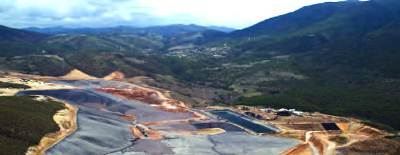
Los Filos mine, Guerrero. Credit: Goldcorp

Los Filos mine, Guerrero. Credit: Goldcorp

The Los Filos project is actively opposed by several environmental groups, including The Mexican Network of People Affected by Mining (La Red Mexicana de Afectados por la Minería, REMA), a network of communities, movements, organization, groups and individuals “affected by, and concerned about, the socio-economic impacts of mining in Mexico”.

REMA has joined the campaign to force Canadian mining firm Goldcorp to halt work at Los Filos. REMA supports the recently created  Mesoamerican Movement Against the Extractive Mining Model, which claims that the existing extractive mining model has proven to be “highly predatory”, and has “significantly increased extraction, causing destruction of territory, seriously affecting natural resources, and irreversibly damaging the health of Mexican citizens”. It is especially concerned that hundreds of tons of cyanide have already been used in Mexico to process gold ore, contaminating water reserves.

REMA cites Goldcorp’s “Los Filos” mining project in Guerrero as a point of particular concern and an example of what is happening throughout the country. REMA claims that there is inadequate regulation and environmental monitoring and that the project is “causing division of communities, disease and death from the chemicals used and environmental damage through drainage of acids and polluting dusts”.

Another Goldcorp mining proposal, at Alto Lucero in the state of Veracruz, also met with substantial opposition from local residents and environmental groups. More information about the amounts of cyanide believed to be used in mines throughout Latin America, including Goldcorp projects, was available via a Map of Cyanide in Latin America (Mapa del Cianuro en América Latina) at http://www.conflictosmineros.net/biblioteca/campana-contra-el-uso-de-cianuro/mapa-del-cianuro-en-america-latina/download [Sep 2013]

Will Los Filos turn out to be a mega-mine or a mega-disaster? Only time will tell.

Related posts:

Case study of the June 2013 ecocide in Hurtado Reservoir, Jalisco

 Mexico's geography in the Press  Comments Off on Case study of the June 2013 ecocide in Hurtado Reservoir, Jalisco
Jul 042013
 

This post presents a short case study of the dramatic ecocide in the Hurtado Reservoir in Jalisco a week ago that resulted in the sudden death of between 200 and 500 tons of fish.

What?

  • The ecocide killed between 200 and 500 tons of fish
  • 30 local residents were affected by gastrointestinal problems
  • 15 of them required treatment in local health centers

Where?

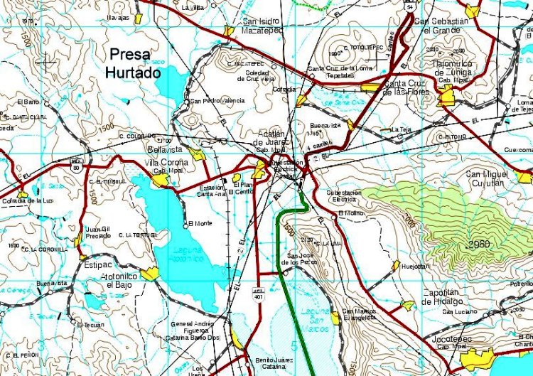
The ecocide occurred in the Hurtado Reservoir (Presa del Hurtado, aka the Valencia Dam) in Jalisco, mid-way between the villages of San Isidro Mazatepec and Bellavista, the location of a sugarcane mill (see map). The reservoir can hold up to 8,000,000 cubic meters of water. The two municipalities involved are Acatlán de Juárez and Tlajomulco de Zúñiga. The most affected community is the small village of San Pedro Valencia (about 300 inhabitants),

Location of Hurtado Reservoir (extract from INEGI 1:250,000 map)

Location of Hurtado Reservoir (extract from INEGI 1:250,000 map)

When?

The first reports were made on 25 June when a local government official in San Pedro de Valencia, in the municipality of Acatlán de Juárez, reported to state environmental protection officials that the water in the Hurtado Reservoir was contaminated with something smelling like molasses. Within 48 hours, officials had identified the source, and had conducted a formal inspection, reporting that the water was dark brown in color and contaminated with molasses.

Why?

According to press reports, an unlicensed firm in nearby Potrero los Charros was using molasses (a by-product of sugarcane mills) as an ingredient to make cattle food. Some of the molasses (melaza) was dumped into the San Antonio stream which carried them into the reservoir.

The problem arose because molasses have a very high biochemical oxygen demand (BOD). This means that they require large amounts of oxygen as they decompose. In this case, they required more oxygen than was available in the water in the reservoir, reducing the water’s dissolved oxygen content, effectively depriving all aquatic life of oxygen. While final results are pending, the fish are believed to have died of oxygen starvation.

Effects

  1. The local fishing cooperative of the Hurtado Reservoir has agreed to accept a moratorium on catching, selling or consuming local fish. The fishermen normally catch and market about 100 kg of fish a day.
  2. Health services are offering vaccinations to local residents and all those involved in the environmental clean-up.
  3. 18 local restaurants are closed until further notice. When they reopen, they will likely have to purchase fish from further away (eg the fish market in Guadalajara) at a higher price than they previously paid for local fish
  4. About 100 fish traders in nearby towns (including Tala, Acatlán de Juárez and Villa Corona) have lost a source of income.

Responses

  1. Within 48 hours of the first report, authorities had ordered the business responsible for the pollution to take immediate remedial action. Meanwhile, authorities began to clean up the dead fish. The fish are being buried in a 30 meter by 2 meter trench about one km away from the lake.
  2. Federal officials from the National Water Commission and the Environmental Secretariat were quickly on the scene; they promised access to federal financial assistance.
  3. Most of the clean up was carried out by about 100 local fishermen and volunteers, including firefighters.
  4. State health officials have closed the 18 small fish restaurants near the lake until further notice
  5. Local officials are also cleaning up the storage area, using tanker trucks to remove an additional 8,000 tons of molasses for appropriate disposal elsewhere.
  6. The municipality of Tlajomulco has issued the owner of the company with a fine of about 1.5 million pesos ($120,000) and further legal action is underway.

Remediation

  • Environmental expert Gualberto Limón Macías estimates it will take between two and four years to rehabilitate the reservoir. The priority is to re-oxygenate the water, possibly using solar-powered pumps, and seed the reservoir with young fish.
  • The University of Guadalajara has promised to arrange for a team of experts to provide specialist advice about how best to rehabilitate the lake.

Related posts:

What are the 10 main pressures threatening the Primavera Forest in Jalisco?

 Other  Comments Off on What are the 10 main pressures threatening the Primavera Forest in Jalisco?
Jun 222013
 

A 1988 Management plan for the Primavera Forest (Plan de Manejo Bosque La Primavera), published by the University of Guadalajara, included a detailed list of the then-existing pressures on the forest.

Sadly, not much has changed since then, and almost all the sources of pressure mentioned in that study still apply today.

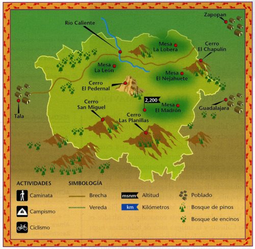
The Primavera Forest. Credit: Semarnat, 2003

The Primavera Forest. Credit: Semarnat, 2003

The management plan argues that the key areas (see map) where careful management is essential include:

  • Cerro San Miguel and Cerro Las Planillas, the highest elevations in the area
  • The environs of the tourist spa of Río Caliente (this spa is now closed)
  • Mesa de Nejahuete, in the center of the volcanic caldera, and
  • Mesa del León, considered an important habitat, primarily for fauna

The plan identifies the following sources of concern (note that this list is in no particular order, and certainly not in order of highest pressure to lowest):

1. Tourism. Poorly planned recreation areas, such as autodromes and spas. Issues resulting from this source of concern include pollution, waste disposal, soil erosion, landscape degradation, habitat change, reduced fauna and, switching to a human focus, delinquency. Motorcycles and trail bikes are a particular problem because of the associated noise pollution, annoyance and risk to other visitors, habitat destruction, the displacement of fauna and often lead to accelerated soil erosion.

2. Ejidos. Any expansion of neighboring ejidos means more homes, deforestation and landscape alteration.

3. Quarrying. The quarrying of local rocks such as pumice or river deposits, as well as a number of abandoned quarries can result in habitat destruction, erosion, forest degradation, accelerated mass movements (landslides, rockfalls), posing a risk to infrastructure, access routes and the potential pollution of ground water.

4. Hunting. Hunters leave spent cartridges that can pollute the soil, as well as wounded and abandoned animals. Larger fauna have become progressively more scarce. In addition, the presence of individuals carrying firearms poses a security threat.

5. Cultivation and Overgrazing. Increased cultivation (primarily for sugar cane, corn and beans) has gradually nibbled away at the edges of the forest, with the clearance method of slash and burn being a particular problem since it greatly raises the risk of wildfires, soil degradation and deforestation. As the number of access routes increases, it is easier for local farmers to graze livestock in the forest, reducing the health of the  grassland, and leading to a relative abundance of unwanted plants and weeds, accelerated soil erosion and the possible contamination of water sources.

6. Deforestation. Deforestation is also a pressure on the forest, in which the cutting of woodland for fuel (including bonfires) and for firebreaks, leads to changes in habitat and soil use, with the secondary effects of increased erosion, reduced ground water recharge and varying degrees of secondary forest succession.

7. Geothermal Power. The potential development of some areas for geothermal power by the Federal Electricity Commission (CFE) has already involved the opening of access routes and would lead to noise contamination (with adverse effects on fauna) and possible pollution of ground water, air and soil, as well as deforested hillsides. The loss of vegetation cover would trigger accelerated erosion, and habitat destruction, further reducing water quality. Access routes attract other “users” such as those seeking to quarry local rocks or clear land for farming.

8. Settlements. Settlements and subdivisions have also encroached on the forest. Some are irregular/illegal settlements, but others are private homes and clubs. Regardless of economic level, these settlements result in a decrease in vegetation and the elimination of the soil’s litter layer, leading to soil compaction, lowered infiltration rates, and nutrient-depleted soils, as well as increased pollution and the gradual elimination of native fauna

9 Wildfires. Wildfires, such as that in 2012, destroy vegetation and cause a general degradation of the woodland. They can result in the accelerated degradation of soil, water and vegetation, leading to significant changes to soil structure, as well as increased runoff and reduced groundwater recharge.

10. Inadequate regulations. The problems faced by the Primavera Forest are compounded because the relevant local authorities have shown little interest in ensuring adequate regulations, supervision and enforcement.

Many of these ten major pressures are closely interrelated. Despite the good intentions back in 1988, it is clear now, with the benefit of hindsight, that the 1988 management plan did not achieve very much. Hopefully, in the not too distant future, and as the Primavera Forest gains international status as a possible Geo-Park, a more comprehensive and effective management plan can be devised and implemented.

Related posts

Mexico and the Environmental Sustainability Index

 Excerpts from Geo-Mexico  Comments Off on Mexico and the Environmental Sustainability Index
Jun 132013
 

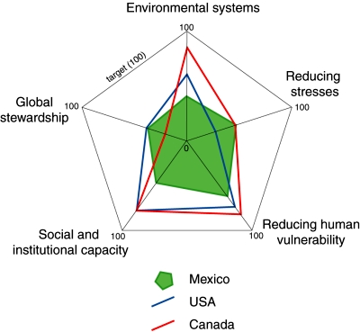
Environmental sustainability is a highly politicized term which almost all nations now eagerly claim as one of their goals. How true are these claims? The Environmental Sustainability Index (ESI) combines five major components (see diagram) which include 76 separate measurements in all. It assesses how close countries are to environmental sustainability. The ESI includes the ecological footprint but also looks at levels of pollution, susceptibility to environmental disruptions, the effectiveness of environmental policies and each country’s contribution to global stewardship.

Comparison of ESI components for Mexico, USA and Canada. (Geo-Mexico. Figure 30.5) All rights reserved.

Comparison of ESI components for Mexico, USA and Canada. (Geo-Mexico. Figure 30.5) All rights reserved.

The countries with the highest ESI scores are predominantly resource-rich nations with low population densities, such as Finland, Norway and Sweden. Some small wealthy states such as Switzerland also make the top ten. In general, densely populated countries such as India and Bangladesh do not score as well.

Mexico’s low ranking in the pilot 2000 ESI table led to Mexico’s Environment Secretariat (SEMARNAT) exploring ways to ensure that international organizations such as the World Bank and World Resources Institute had faster access to updated data from Mexico. Government policy was modified to embrace the use of quantitative environmental data relating to sustainability.

In terms of global stewardship, Mexico and the USA are closer to the target for environmental sustainability than Canada (see diagram). For reducing environmental stresses, Mexico and Canada are ahead of the USA. However, for the other three components, Mexico lags well behind both its North American partners.

Related posts:

Five Mexican beaches gain international Blue Flag certification

 Mexico's geography in the Press  Comments Off on Five Mexican beaches gain international Blue Flag certification
Jun 032013
 

For the first time ever, five Mexican beaches have been awarded Blue Flag certification. The Blue Flag system is a voluntary, international eco-label program run by the non-government, non-profit organization the Foundation for Environmental Education that recognizes beaches where water quality is excellent, where information and environmental education is readily available, and which are well managed, with high standards of safety and services. The announcement was made in Copenhagen, Denmark, where Blue Flag certification was given to 3100 beaches and 625 marinas worldwide.

Blue flag beaches in Mexico 2013

Mexico’s five Blue Flag beaches (see map) are:

  • Chahué, Santa María de Huatulco, Oaxaca
  • Chileno, in Los Cabos, Baja California Sur
  • Delfines, in Cancún, Quintana Roo
  • El Palmar, in Zihuatanejo, Guerrero
  • Nuevo Vallarta Norte, on Banderas Bay in Nayarit

What does the Blue Flag system take into account?

The Blue Flag beach criteria are grouped into four main categories:

1. Environmental Education and Information

The beach must host at least 5 environmental education activities and display information about:

  • coastal zone ecosystems and natural, sensitive areas in the coastal zone
  • bathing water quality
  • the Blue Flag system
  • the code of conduct for the beach area

2. Water Quality

  • Water quality must be “excellent” in line with international standards
  • The beach must not receive any industrial or sewage-related discharges
  • Any nearby coral reefs must be monitored to ensure they remain healthy
  • Algae, seaweed, etc., should be left on the beach unless it adversely affects beach quality

3. Environmental Management

  • A beach management committee must conduct regular environmental audits
  • The beach must comply with coastal zone planning and environmental legislation
  • The beach must be clean, with sufficient waste disposal and recycling bins
  • There must be adequate and clean sanitary facilities
  • Regulations must prevent unauthorized camping, driving and dumping
  • Regulations concerning beach use by domestic animals must be enforced
  • Sustainable means of transportation must be promoted in the beach area

4. Safety and services

The beach must have:

  • first aid equipment and an adequate number of lifeguards and/or lifesaving equipment
  • a system to manage beach use and prevent conflicts and accidents
  • emergency plans to cover any unexpected pollution event
  • safe access to the beach and regular safety patrols
  • a supply of potable drinking water
  • access and toilets for persons with disabilities
  • a map showing the location of all facilities

Related posts:

Environmental news briefs relating to Mexico

 Mexico's geography in the Press  Comments Off on Environmental news briefs relating to Mexico
Apr 022013
 

This post describes several newsworthy developments relating to Mexico’s natural environment.

Financing to fight deforestation

The Inter-American Development Bank is giving Mexico $15 million in financial and technical assistance to support climate change mitigation efforts. The program will help communities and ejidos finance low carbon projects in forest landscapes in five states, all of which have high levels of net forest loss: Oaxaca, Yucatán, Quintana Roo, Jalisco and Campeche.

The program includes a $10 million loan for financing projects that must reconcile economic profit for the communities and generate environmental benefits through reducing the pressure on forests and promoting enhancement of carbon stocks. In addition, a $5 million grant will provide financial and technical assistance to support the viability of individual projects, by strengthening technical, financial and management skills.

The IDB says that the program is a pilot project that will allow lessons to be learned for its replication in other key geographic areas in Mexico. It should demonstrate a viable business model that promotes the reduction of deforestation and degradation while increasing economic returns. [based on an IDB press release]

Mexican company converts avocado seeds into biodegradable plastic

A Mexican company called Biofase has developed a way to turn avocado pits into 100% biodegradable plastic resins. Avocado pits are normally discarded as waste. Biofase will collect some of the estimated 30,000 metric tons of avocado pits discarded each month for processing. The company has patented the technology and is looking for additional raw material containing some of the same chemicals as avocados.

Huichol Indians oppose peyote conservation measure

A presidential decree signed last November prohibits the harvesting of the hallucinogenic peyote cactus from two protected areas in the state of San Luis Potosí. The decree has met fierce opposition from the indigenous Huichol (Wixarika) people, for whom the peyote is a sacred plant. The Huichol undertake a lengthy pilgrimage each year to gather peyote for subsequent use in their ceremonies.

The restriction on peyote harvesting is the latest in a long line of problems faced by the Huichol including the incursion by a large number of mining companies onto traditional territory. The Regional Council for the Defense of Wirikuta has demanded that the government guarantee the Huichol’s right to pick peyote, and called for the cancellation of 79 mining concessions (most of them to Canadian companies) that impinge on their sacred land. Critics claim that mining is having a devastating impact on the local environment, especially because the companies involved are using large quantities of highly toxic cyanide.

Expand the port or protect the coral reef?

In Avalan destruir arrecifes para ampliar puerto de Veracruz published in Mexico City daily La Jornada, Luz María Rivera describes how one of the final acts of the previous administration was to redraw the boundaries of the protected area of coral reef off the coast of Veracruz state. The new boundaries have reduced the protected offshore area near the cities of Veracruz, Boca del Río and Alvarado by about 1200 hectares (3000 acres). The redrawing of the protected area is to enable the expansion of the port of Veracruz, one of the country’s largest, and almost double its capacity. Government officials claimed that the area affected was already “damaged” and that the reef system was 98% or 99% “dead”.

Government-NGO accord to protect Mexican whale sanctuary

The Mexican government has signed an accord with the NGO Pronatura Noroeste to improve the protection of Laguna San Ignacio, the Pacific coastal lagoon which is a major breeding ground for gray whales. The lagoon has 400 kilometers (250 miles) of coastline, bounded by wetlands and mangroves, and is part of the El Vizcaino Biosphere Reserve in the northern part of the state of Baja California Sur. The accord calls for joint development of plans for protection, monitoring and tracking the whales and other species that inhabit the lagoon, as well as  establishing protocols for resolving any eventual environmental contingencies.

Related posts:


Pemex boosts reserves and reduces its emissions

 Mexico's geography in the Press, Updates to Geo-Mexico  Comments Off on Pemex boosts reserves and reduces its emissions
Dec 032012
 

It may come as something of a surprise to many observers, but during 2012, Mexico’s state-owned oil company Pemex (Petróleos Mexicanos) has received several well-deserved plaudits for its efforts to slash the emissions associated with oil and gas exploration, reserves and production.

For the fifth consecutive year, the Global Reporting Initiative awarded Pemex the highest possible rating for social responsibility. The company also received excellent ratings for sustainable asset management. During 2011, Pemex’s proven reserves increased 1.1%, while the petro-giant cut total emissions by 17.3% compared to the previous year. Crude oil output averaged 2.55 million barrels a day in 2011. Carbon dioxide emissions were down 8.8% in 2011, while sulfur oxides have now fallen more than 50% since 2007.

Meanwhile, the production division of Pemex has been praised by World Bank experts for having reduced burn-off from its giant Cantarell gas field from 31% in 2008 to 3% in July 2011. Pemex has invested more than 1.6 billion dollars in the Cantarell field over the last six years in order to improve efficiency, with the installation of compressors, flow separation devices and re-injection technology. In the past three years, it has reduced total emissions, including greenhouse gases, from 13.6 billion cubic meters a year to 2.1 billion. Pemex is well on track to beat its target of 99% efficiency in gas recovery by 2014.

Crude oil production has risen steadily in 2012. For example, in August 2012, Pemex produced 2.56 million barrels of oil a day (b/d), its highest output since May 2011. The Chicontepec field in Veracruz is doing especially well. Its single best-performing well, named Presidente Alemán 1565, uses innovative technology, including three dimensional seismic mapping and horizontal drilling, to yield as much as the combined output of 28 other wells in the region.

Mexico’s current 3P (proven, probable, possible) reserves are also on the rise, and currently total 43 billion barrels of crude oil equivalent. After years of depletion, Pemex is now adding more oil and gas each year to its reserves than it is extracting. The oil giant recently announced a huge deep water, light crude discovery in the Gulf of Mexico, off the coast of Tamaulipas, its first major find in the Perdido Fold Belt, where the total 3P reserves could be as high as 10 billion barrels. The Trión-1 well, drilled to a total depth of 4,500 meters (14,800 feet), is 40 km (25 miles) inside Mexico’s territorial waters and is expected to yield up to 400 million barrels of high quality crude.

Pemex also recently reported the largest land-based discovery of oil for about a decade. The Navegante-1 well, drilled in the South-East Basins 20 km from Villahermosa (Tabasco) found light crude oil with an APR gravity of 45 degrees, at a depth of 6800 meters. The field is 87 square kilometers in area and has estimated 3P reserves of about 300 million barrels of crude oil equivalent.

Related posts:


The geography of tequila: trends and issues

 Other  Comments Off on The geography of tequila: trends and issues
Sep 152012
 

The production and export of tequila has been one of Mexico’s major agro-industrial success stories of recent times. In this post, we look at some of the related trends and issues.

Rapid rise in production

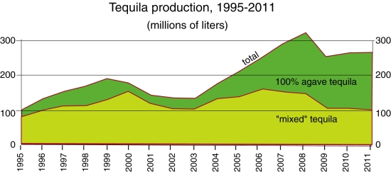
For the period 2009-2011, Mexico produced about 250 million liters of tequila a year. Of this total, 60% was “100% agave tequila“, where all the sugars are directly derived from the Agave tequilana weber azul, and the remaining 40% was “mixed tequila” (tequila mixto) where at least 51% of the sugars are from Agave tequilana weber azul, but the remaining sugars come from other non-agave sources.

Tequila production, 1995-2011. Data: Tequila Regulatory Council.

Tequila production, 1995-2011. Data: Tequila Regulatory Council.

This is a dramatic increase compared to the period 2001-2003, when the average production was about 140 million liters a year. During that period, 100% agave tequila contributed only about 20% of the total. The relative importance of 100% agave tequila has clearly increased very rapidly in the past decade.

Agave supply: from shortage to glut

While there is a clear upward trend in total production, there are periods where production has fallen, most recently from 2008 to 2009, when production fell by 60 million liters. One of the possible reasons for a short-term blip in tequila production is if there is a shortage of agave. Agaves take about 10 years to mature, so there is a lengthy time lag between planting and the first harvest of newly planted areas.

As demand for tequila has risen, some of the major producers have experienced temporary shortfalls and been unable to source as much agave as they would have liked. One of the consequences was that independent agave producers entered the market, seeking to profit from such periods. Such independent producers could do well, provided they were able to predict agave shortages a decade in advance. During the 1990s, hillsides all over Jalisco were planted with agave, many for the first time, providing a significant boost to agave supply a decade later.

Not all independents came out of this on top. The supply of agave now exceeds demand. Many of the major tequila companies have increased their own acreage of agave, or have signed forward-looking contracts with major independent growers in other areas of the designation of origin zone. Many independent agave farmers are losing out; they planted agave a decade ago, but failed to forecast the current glut.

Tequila makers currently consume about 1 million metric tons of agave a year. The Agriculture Secretariat estimates that there are about 20,000 independent growers who have no contracts, and 223 million agave plants of diverse ages for which there is no current or short-term market. As many as 30 million agave plants were considered “very mature” in 2009 and a total loss in 2010. It is likely to be several years before the production of agave falls back to a level sustainable with demand.

Exports continue to rise

Tequila exports have risen very rapidly since 2001, with only minor anomalies along the way. Mexico currently exports about 160 million liters a year. Tequila exports have performed well despite the now lengthy economic woes being experienced by the major importing countries.

Foreign ownership

Mexico’s tequila makers have undergone a similar experience to the country’s major brewing companies, in that all but one of the major tequila firms are now owned by foreign corporations. A proposed deal in which the last of the big Mexican tequila companies, José Cuervo, would also have been taken over by British firm Diageo (which owns Baileys, Johnnie Walker, J&B, Smirnoff, Captain Morgan and Guinness) was called off in December 2012.

Environmental concern

The major environmental problem associated with tequila making is wastewater. For every liter of tequila, 10 liters of wastewater (vinazas) are produced. The vinazas are nitrogen-rich, and contain high concentrations of chemicals, including heavy metals and salt.

The National Chamber of the Tequila Industry recognizes that only about 60% of vinazas are disposed of properly. Most of the remaining 40% (about 2.5 billion liters in 2008) are thought to be pumped untreated into local streams and ponds, damaging the ecosystem and destroying stream life.

The Mexican government fines distilleries that do not have adequate treatment plants for the vinazas they produce, but in the past many companies have opted to pay the fines rather than solve the problem at source.

The vinazas problem was one of the reasons why UNESCO recently considered revoking the Tequila region’s World Heritage status, awarded in 2006. Another issue that made UNESCO unhappy was a recent decision to locate a landfill site in Amatitán in the center of the World Heritage zone. In the end, UNESCO officials agreed that progress was being made; the area kept its heritage status.

There is hope on the horizon. A new cost-effective option for tequila firms seeking to dispose of viñazas has been developed by a local corporation Tecnología Nacional de Aguas. Called Proshiemex, it uses the viñazas to produce methane-rich biogas which can contribute to heating the boilers of the tequila distilleries. The remaining sludge can be easily treated in accordance with all applicable environmental norms.

Source of data:

  • Tequila Regulatory Council Statistics

Related posts:

Threats to the traditional Tarahumara way of life, part two

 Other  Comments Off on Threats to the traditional Tarahumara way of life, part two
Sep 132012
 

In the first part of this two-part article – Threats to the traditional Tarahumara way of life, part one – we looked at the threats to traditional Tarahumara life posed by alcohol, deforestation and the construction of new or improved roads in the Sierra Tarahumara (Copper Canyon) area.

In this part, we consider the impacts of drug cultivation, mining and tourism.

Drug cultivators and drug cartels

The incursion of drug cultivators seeking land for growing marijuana and opium poppies into the Canyon country has further marginalized the Tarahumara, sometimes labelled “Cimarones” (“Wild Ones”) by the newcomers. Drug cultivators have sometimes registered parcels of land as theirs and then ejected the Indians by force. Obviously, they choose the best available land, and their cultivation methods are designed to produce quick results, rather than sustainability.

Alvarado (1996) divides anti-drug policy into various time periods. First came an emphasis on catching those responsible, then came exhaustive efforts to eradicate the crops. Crop eradication has its own serious environmental downside, since it involves the widespread and indiscriminate use of aerially-applied herbicides, alleged to include Agent Orange, Napalm and Paraquat.

Alvarado’s study is an interesting analysis of the incredible, quickly-acquired wealth (and accompanying violence and corruption) that characterizes some settlements on the fringes of the Sierra Tarahumara. In some towns, for example, there are few visible means of economic support but the inhabitants are able to purchase far more late-model pick-ups than can their counterparts in major cities. Murder rates in these towns are up to seven times the Chihuahua state average. Violence even has a distinct, seasonal pattern, with peaks in May-June (planting time) and October-November (harvest time).

The levels of violence and injustice led Edwin Bustillos (winner of the 1996 Goldman Prize for Ecology) to change the focus of CASMAC, the NGO he directed, from environmental conservation to the protection of Tarahumara lives. In 1994, CASMAC was instrumental in stopping a 90-million-dollar World Bank road-building project that would have opened up still more of the Sierra Tarahumara to timber companies.

Mining

Besides deforestation and its resultant impacts, mining has had several other adverse effects on the Tarahumara and the local landscape. Mining activity has increased in the past decade as metal prices have been high and the federal government has encouraged foreign investment in the sector. Mining leads to a reduction in wildlife and to the contamination of water resources. The most damaging pollutants are heavy metals.

Tourism

Even tourism poses a potential threat. In the past decade, investments totaling 75 million dollars have been made to improve infrastructure (highways, runways, drainage systems, water treatment facilities, electricity) in the Copper Canyon region so that the area has the hotels, restaurants and recreational activities to handle six times the current number of visitors. The plan includes three remodeled train stations and a cable car that is already in operation. Sadly, the Tarahumara were not consulted. The plan essentially deprives them of some communal land with nothing being offered in exchange. Clearly, they are in danger of losing control over even more of their natural resources, especially since improved highways will benefit other groups such as drugs growers.

Anthrologist María Fernanda Paz, a researcher in socio-environmental conflicts at UNAM’s Regional Center for Multidisciplinary Studies, argues that these recent conflicts in the Copper Canyon region have stemmed from the federal government’s support for inflows of foreign capital, helped by modifications to the land ownership provisions enshrined in article 27 of the Constitution, changes made in 1992 during the administration of President Carlos Salinas de Gortari. In her view, the developers behind contentious projects first do everything possible to hide the project from public view until it is well advanced. Once people start to object, they then identify the community leaders and do everything possible to get them on their side. Before long, they have succeeded in creating a massive rift in the community, paying some very well indeed for their land, and others next to nothing.

Finally, the good news

The  Tarahumara recently (12 March 2012) won one of the greatest victories to date for indigenous peoples in Mexico. The Tarahumara (rarámuri) community of Huetosachi in the state of Chihuahua has now been recognized by Mexico’s Supreme Court as having long-standing indigenous territorial rights (but not formal ownership) that must be respected by the Copper Canyon Development Fund (Fideicomiso Barrancas del Cobre). This is truly a landmark victory. The Tarahumara have been guaranteed the right to be consulted over all Development Plans, and to select the benefits they will receive in exchange for any loss of ancestral territory. Finally, this juggernaut of a tourist development plan must respect the territories and natural resources of the Tarahumara.

This was truly David against Goliath. Huetosachi is a tiny settlement of only 16 families, about 10 km from where the main tourist complex is being built near the Divisadero railway station. The village has no water, electricity or health services.

The Copper Canyon Development Fund is now obligated to create a Regional Consultative Council allowing the villagers of Huetosachi and other settlements a say in the negotiations to decide what level of development is acceptable, and what the villagers expect in return. This council is expected to include representatives of 27 indigenous communities in the immediate area between Creel and Divisadero.

This landmark court decision could well be the first of many as indigenous groups elsewhere in Mexico fight their own battles against developers of various kinds. There could still be more court cases concerning the Copper Canyon region since it is widely expected that this initial success will lead to a legal challenge against the siting of the cable car. The villagers are also reported to be discussing how best to deal with water contamination allegedly resulting from existing hotels, and the possibility of a golf course being built on the canyon rim.

Sources:

  1. Alvarado, C.M. (1996) La Tarahumara: una tierra herida. Gobierno del Estado de Chihuahua. Somewhat repetitive academic analysis of the violence of the drug-producing zones in the state of Chihuahua, based in part on interviews with convicted felons.
  2. Merrill, W.L. (1988) Raramuri Souls – Knowledge and Social Progress in North Mexico. Smithsonian Institution, Washington D.C.
  3. Nauman, T. (1997) “Tala ilegal para la siembra de mariguana y opio en Chihuahua” p. 50 in El Financiero, May 12, 1997. Describes the Arareko project.
  4. Plancarte, F. (1954) El problema indígena tarahumara. INI. Mexico. Spanish language description published by National Indigenous Institute.
  5. Shoumatoff, A. (1995) “The Hero of the Sierra Madre” pp 90 – 99 of Utne Reader (July-August, 1995), reprinted from Outside (March 1995). An account of the determined efforts by Edwin Bustillos to prevent further environmental destruction in the Copper Canyon region.

Related posts:

Threats to the traditional Tarahumara way of life, part one

 Other  Comments Off on Threats to the traditional Tarahumara way of life, part one
Sep 102012
 

The extreme isolation of the Tarahumara (until recent years) and their adaptation of some elements of the alien Spanish/Mexican culture have enabled them to survive in what most observers would regard as an extraordinarily hostile natural environment. The effects of this isolation are reflected in their culture, in their relatively equal gender roles in terms of their economy, their flexibility of work schedule, lack of economic specialization and their willingness to share available food when necessary to ensure survival.

Their isolation has also hindered the emergence of any well‑defined leadership system. A lack of any “official” hierarchy make it much more difficult to resolve any serious disputes. It has also meant that the shy and politically naive Tarahumara have found it difficult to counteract intruders, whether they are government officials or drug‑dealers. As more roads are improved, even the furthest, most remote sanctuaries, of the Tarahumara come under threat.

Some Tarahumara have adopted more mestizo culture than others; the “gentile/baptized” distinction, first recognized by Lumholtz, with all its associated differences in settlement patters and lifestyle arose from the resistance of many Tarahumara to the imposition of a Spanish/mestizo culture that they considered “alien”. The more traditional Tarahumara still prefer to live in relative isolation and not to resettle into fixed villages where there would be insurmountable pressure on their culture.  The mestizos in the Copper Canyon region, who occupied the best land by force and formed villages in the European‑derived tradition, have far more links with modern Mexico, and have preserved their economic dominance over the Indians.

None of this means that the traditional Tarahumara way of life has remained unchanged or will not continue to undergo modifications in the future. Any changes to the environment can have serious adverse impacts on their abilities to find sufficient food. The main drivers of environmental change have been drug-growing, forestry, mining and tourism.

In addition, they have to manage changes which, to some extent, have been thrust upon them by some of the government and other efforts aimed at helping them. For example, modern medicine and education threaten to change the Tarahumara population balance. Today, more infants survive to adulthood and fewer adults die as a result of accidents. The problem for the Tarahumara is how to feed and support an ever‑growing population using existing methods of cultivation and herding.

Alcohol

Equally important is the transformation of the traditional Tarahumara system of wants by contact with mestizos. Prior to these contacts, the Tarahumara had little or no access to commercially-made alcohol. Tarahumara tesgüino took considerable time and effort to make and had to be consumed rapidly, meaning that Tarahumara could get drunk occasionally, but could not remain drunk for long. The ready availability of commercial alcohol has completely changed this dynamic.

Slightly over a decade ago, an innovative, women-led project reportedly changed the 3500-inhabitant community of Arareco (8 km from the town of Creel) for the better. Kari Igomari Niwara, a 200-member women’s organization, began in 1992, and is celebrating its 20th anniversary this year. It has often been quoted as an outstanding example of what the Raramuri (Tarahumara) can do if left to their own devices and allowed to control their own resources. In this project, they have sought encouragement and support, rather than direction and dependence. By 1997, Kari Igomari Niwara had organized a health center, primary school, bilingual literacy program, drinking water system, bakery, three small food supply stores, a handicrafts business, a restaurant and collective transportation for the village.

One of the first collective efforts of the Kari Igomari Niwara group was to get the cantinas (bars) of Creel closed at 4pm in the afternoon, so that their husbands wouldn’t get so drunk. Almost 70% of Arareco women reported having been beaten by their husbands, the vast majority of attacks coming when their husbands were drunk. After the initial cantina victory, the men became even more repressive, but the women persisted and four years later managed to persuade the church to build them a small health center despite the objections of their local male-dominated council. The women have already reduced nutrition-related infant mortality to 25% of its former level and have brought birth rates down by 50%  (Nauman, 1997).

Deforestation

The deforestation of the Copper Canyon region has a long history and has significantly changed the resource base of the Tarahumara to the point where their traditional way of life in the canyons is probably impossible to sustain in the future. Deforestation was started by mining companies who cut trees to make pit props and burn as fuel. In the 1890s, the region started to supply timber to the USA, via concessions given by Chihuahua state governor Enrique Creel to companies such as the Sierra Madre Land and Lumber Company, owned by William Randolph Hearst. Today, many of the local ejidos continue to cut more timber than they can ever replant, and there are more sawmills in operation than could ever be sustainable.

In many places, there are clear signs of the immense environmental destruction wrought by timber cutting, often on slopes so steep that there is little chance of reforesting them in the future. Soil erosion is rampant in some areas and satellite imagery reveals huge areas that are no longer forested.

Recent droughts have not helped, and one NGO, Alternative Training and Community Development (ALCADECO) has explored their links with deforestation and migration. The NGO’s director, Laura Frade, argues that the long-term effects of drought go far beyond the obvious. Poor crops in times of drought results in the abandonment of traditional lands. Families become dependent on poorly-paid jobs in the timber industry, or on drug plantations, or dependent on the sale of handicrafts to tourists. Many of those that fail to make ends meet then become the unwilling recipients of blankets and food from charity organizations. Others move to cities like Chihuahua, where they try to survive by begging or turn to alcohol.

New and improved roads

The development of forestry required the development of roads and vehicle tracks. Road development continues to this day and is not necessarily a beneficial thing. Improved road access has opened up new areas for lumbering, mining and tourism. In turn, small stores spring up, even in remote areas, selling mestizo items such as radios, carbonated drinks, cigarettes, and manufactured clothing. The use of money has become more widespread. Better roads have enabled traders to build a credit relationship with Tarahumara Indians, offering them non-traditional goods in exchange for a share of the next maize harvest. This has led to typical problems of indebtedness and exploitation.

Further reading:

Sources:

  1. Lartigue, F. (1970) Indios y bosques. Políticas forestales y comunales en la Sierra Tarahumara. Edicions de la Casa Chata # 19, Mexico.
  2. Lumholtz, C. (1902) Unknown Mexico. 2 volumes. Scribner’s Sons, New York. Republished in both English and Spanish. Fascinating ethnographic account from the last century.
  3. Nauman, T. (1997) “Tala ilegal para la siembra de mariguana y opio en Chihuahua” p. 50 in El Financiero, May 12, 1997. Describes the Arareko project.
  4. Vatant, Francoise. La explotación forestal y la producción doméstica tarahumara. Un estudio de caso: Cusárare, 1975-1976. INAH, Mexico.

Related posts:

Founder of Grupo Ecológico Sierra Gorda honored by National Geographic

 Mexico's geography in the Press  Comments Off on Founder of Grupo Ecológico Sierra Gorda honored by National Geographic
Jun 252012
 

Mexican environmentalist Martha “Pati” Isabel Ruíz Corzo has been awarded the 2012 National Geographic/Buffett Award for Conservation Leadership in Latin America.

The press release from the National Geographic summarizes a lifetime’s dedication to the Sierra Gorda region of the state of Querétaro:

Martha “Pati” Isabel Ruiz Corzo founded Grupo Ecológico Sierra Gorda (GESG), a local grassroots organization, with her husband and local residents in 1987 to rescue the Sierra Gorda bioregion in Mexico from the destruction of unregulated development. GESG has set the standard in Mexico for a “conservation economy,” establishing a new paradigm in natural protected area management with widespread local community participation.

GESG is a living model of community-based conservation management. Thanks largely to GESG’s efforts and Ruiz Corzo’s leadership, the Sierra Gorda — comprising a third of Mexico’s Querétaro State and considered the area with the most ecosystem diversity in Mexico — is now a UNESCO and federal Biosphere Reserve and is the largest federal protected area with participatory management in the world. It spans 1 million acres, and its 35,000 residents own 97 percent of the Reserve’s territory.

Ruiz Corzo’s efforts to include local communities in the management of the Reserve make her a pioneer in the conservation field. Her leadership has created opportunities for rural, low-income communities in the areas of ecotourism, reforestation, soil restoration, ecological livestock management and other profitable microenterprises.

Over the past 25 years, GESG has organized environmental education for the community members, who regularly take part in clean-up campaigns, solid waste management, soil restoration and other conservation activities. Community volunteers operate 115 recycling centers. Thanks to the residents’ stewardship of the Reserve, more than 13,000 hectares of regenerated forest and woodland has been recovered over 15 years.

Ruiz Corzo and her team have developed online and on-site courses that allow others to replicate the GESG model, which is now being applied beyond the borders of Mexico.

Ruiz Corzo also has pioneered the concept of valuing the “natural capital” of the region — the Sierra Gorda has been validated by the Rainforest Alliance and is the first forest carbon project to achieve this milestone in Mexico.

The Sierra Gorda Biosphere Reserve covers 383,567 hectares of the state of Querétaro. Eleven core protected areas have a combined area of 24,803 hectares with 358,764-hectares of buffer zone surrounding them. The reserve is home to about 100,000 people (including cattle ranchers, seasonal farmers and forestry workers) living in 638 settlements in five municipalities:

  • Jalpan de Serra
  • Arroyo Seco
  • Landa de Matamoros
  • Pinal de Amoles
  • Peñamiller

The reserve is ecologically diverse, with a large number of distinct ecosystems; it is one of the most biodiverse areas in central Mexico. The major reason for such diversity is that the reserve straddles the Nearctic and Neotropical bio-regions. It ranges in altitude from 300 meters above sea level to more than 3,000 meters. The reserve has 14 distinct vegetation types, home to 6 feline species (including the jaguar) and 334 bird species.

Forestry is controlled, but illegal logging persists, especially on the fringes of the reserve.

Out-migration has reduced population pressures on the reserve, and remittances have helped raise household incomes, so decreasing local demand for wood as fuel in favor of gas.

Related posts:

Jun 172012
 

Good news for Mexico’s coastline! The controversial Cabo Cortés mega-resort project in Baja California Sur, Mexico, has been cancelled, with President Felipe Calderón announcing that in “such an important area for the Gulf of California and the country … we should all be absolutely certain that [the project] will not cause irreversible harm”. However, Calderón did not rule out the possibility that a revised, more sustainable project might meet government approval.

As detailed in several previous geo-mexico.com posts, the Cabo Cortés project had been opposed by local residents, fishermen, environmental groups including Greenpeace and many academics:

The president of the Mexican Center for Environmental Law, Gustavo Alanis, hailed the government’s decision as “a triumph for conservation, environmental protection and nature.” He said that it is “a message in favor of legality and the rule of law in the environmental sphere” that would make clear to potential investors that they are welcomed as long as they respect nature and comply with existing environmental laws.

Value-added from solid waste in Mexico

 Mexico's geography in the Press  Comments Off on Value-added from solid waste in Mexico
Dec 142011
 

In a previous post, we looked briefly at the role of plastics recycling in Mexico City’s waste separation program. In this post, we describe two other developments related to solid waste disposal.

Recycling finally reaches the take-off point in Mexico

Nationwide, it took an entire decade for the plastics recycling rate in Mexico to increase from 10 to 15%. Then, in 2010, as more companies sought part of a potentially very lucrative market, the rate shot up to 17%. Admittedly, though, Mexico still lags far behind the 22% rate boasted by the European Union members in this regard.

Mexican industry generates 3.8 million metric tons of plastic waste a year (36% of it in Mexico City). The nationwide recycling capacity for plastics (geared towards hard plastic or PET) currently stands at only 646,000 metric tons, so there is plenty of room for more companies and recycling plants.

Garbage-powered street lights

The World Bank is helping finance a new bio-energy project in Monterrery which will reduce emissions by the equivalent of a million tons of CO2. This is about the same quantity as the annual emissions of 90,000 vehicles, or the amount of CO2 that would be absorbed annually by a forest with an area of 970 hectares.

The project, run by Bioenergía de Nuevo León, uses methane gas given off by decomposing garbage in one of the city’s landfills, in Salinas Victoria, which receives 5000 tons of garbage a day. The power plant’s installed generation capacity of 17mW should be sufficient to supply 90% of the nighttime street lighting in the Monterrey metro area. During the day, power from the project is supplied to the city’s metro system. Any surplus is sold to the Federal Electricity Commission and fed into the national grid.

photo of garbage

Recycling has a long way to go...

Related posts:


Sep 122011
 

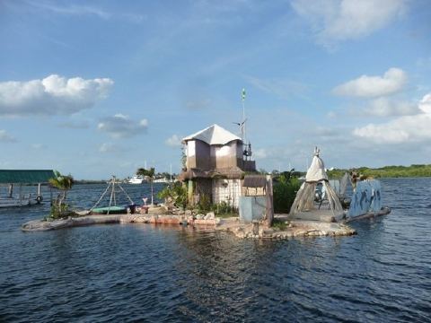
Richie (Rishi) Sowa is back! In 2002, Sowa, a former carpenter from Middlesbrough in England, completed the construction of his own private island paradise off the coast of Quintana Roo—built entirely of plastic bottles. Amazing but true! Sowa painstakingly constructed his island, known as Spiral Island, using more than 200,000 plastic bottles, and then lived on it! Unfortunately, his island home was entirely demolished by Hurricane Emily in 2005.

This was seemingly only a minor defeat since Sowa has since completed an even bigger and more resilient island on which to live, using the knowledge acquired from Spiral Island. His new creation is known as Joysxee. It is currently tethered to the island of Isla Mujeres, north of Cancún.

Joysxee

Joysxee. Photo: Rishi Sowa

Besides plastic bottles, Sowa used discarded wood and has planted vegetation including mangroves to help stabilize his home. His latest plan is to install a wave-powered propulsion system, allowing him to relocate his island at will, something I’m guessing he’s going to do next time a hurricane comes roaring in!

For Joysxee, Sowa has so far “reused” 125,000 plastic bottles. The island is 25 meters in diameter, and fitted with solar panels, a wave-powered washing machine. It comes complete with its own waterfall, river and (small) lakes. The island is designed to allow Sowa to be largely self-sufficient. The island’s vegetation includes many food sources such as palm trees, cacti, spinach, melons, lemons and tomatoes. The island will act as home to corals and fish as well.

Sowa’s ambition? To sail his eco-island round the world. He is the latest in a long line of English eccentrics, but you can only admire his creativity, artistry, vision and determination. Other people have sunk rusty old ships to make new underwater reefs, but how many have built an entire island from scratch, using discarded plastic bottles?

Not surprisingly, Joysxee, Sowa’s amazing home, has become an increasingly popular tourist attraction, receiving dozens of curious visitors a day. It is also a testimony to ecological sustainability.

Read more:

Want to support Joysxee?

Which cities have the best and worst water systems in Mexico?

 Books and resources  Comments Off on Which cities have the best and worst water systems in Mexico?
Aug 182011
 

The Water Advisory Council (CCA), a Mexican NGO specializing in water research, education and policy, has published its 2011 report on Mexico’s water management, sewerage and sanitation. The report looks at data for 50 Mexican cities, each of which has a population in excess of 250,000.

The report —Gestión del Agua en las Ciudades de México (Water Management in Mexican Cities)— uses data for 20 variables to develop the following 10 indicators: drinking water coverage; drainage and sewerage coverage; continuity and extension of services; productivity; metering; physical efficiency; business efficiency; operating income; wastewater treatment; and institutionalization.

In terms of overall performance, the city of León came top, followed by Saltillo, Monterrey, Mexicali, Aguascalientes, Cancún and Tijuana. Of the top six, three (Saltillo, Aguascalientes and Cancún) are managed by private operators, while León, Mexicali and Tijuana are public water systems. There is clearly no discernible difference between the performance of private operators and the best public systems. Towards the bottom of the rankings, all the cities have public water systems. The worst-ranking cities include several in the State of Mexico, as well as others in the south and southeast of the country.

For water quality, the leader was Ciudad Victoria, followed by Colima, Monterrey, León, Torreón, Tepic and Hermosillo. The ten worst were Villahermosa, Cuernavaca, Acapulco, Oaxaca, Xalapa, Chetumal, Chilpancingo, Celaya, Chimalhuacán and Campeche.

For efficiency, the leader was Saltillo, followed by León, Monterrey, Tijuana and Aguascalientes. The least efficient were Ecatepec, Campeche, Villahermosa, Celaya, Chilpancingo and Chimalhuacán.

The report says that where the private sector is involved, the important issues are transparent tenders; clear, balanced and flexible contracts; effective controls to prevent abuse; legal certainty; and effective regulation with stable, long-term regulating agencies.  The authors also emphasize the importance of pricing that reflects costs, and of removing the payment exemptions currently given to government agencies.

The Water Advisory Council argues that the Federal Agency for Environmental Protection (PROFEPA) should be in charge of all water monitoring, though its powers need strengthening to ensure it can fully carry out its mandate.

The troubled rise of the Green Movement in Mexico

 Other  Comments Off on The troubled rise of the Green Movement in Mexico
Aug 012011
 

Two specific events helped stimulate the rapid growth of Mexico’s green movement in the 1980s:

These motivated many citizens to take direct action. Membership in Environmental Non-Governmental Organizations (ENGOs) surged, as “green brigades” aided the victims. Two months after the earthquake, representatives from 300 regional groups met and formed a coalition of green groups focused on issues such as deforestation, pollution, and opposition to nuclear power. The 1992 Rio UN Environmental Summit and opposition to NAFTA (because it neglected environmental issues) provided additional stimulus to the movement.

The number of ENGOs increased from fewer than 30 in 1985 to about 500 by 1997 when about one in twenty Mexicans was a member of an ENGO.  The ENGOs had highly professional staffs and were well funded from Mexican and international sources. Through demonstrations and militant actions they successfully stopped the construction of a half billion dollar tourism complex south of Mexico City and the proposed world’s largest salt mine in Baja California. They also were significant in the passage of new laws for environmental protection, reducing deforestation, protecting wildlife, and establishing protected areas.

Vicente Fox, the PAN/Green Party candidate, won the Presidency in 2000.  His Minister of the Environment, Víctor Lichtinger, brought scores of highly qualified fellow key ENGO leaders into the administration. While this put the nation’s leading environmentalists on the inside, it also essentially “decapitated” and deflated the ENGO movement, especially its more militant members. Despite these key appointments, Fox’s administration gave relatively low priority to environmental issues. When Fox sided with tourism investors, and decided against issuing a detailed analytical report on beach pollution, Lichtinger and many of his senior staff resigned. They mostly moved to international or academic positions and consequently did not rejuvenate the leadership of the ENGOs they had left.

Green party logo

Green party logo

For the 2006 election, the Green Party formed an alliance with PRI and came in a weak third. The party, which has suffered from despotism, bribery and violation of election laws, managed to elect 22 diputados in the 2009 election. The Calderón Presidency has obtained good environmental marks for its leadership in global warming; however its comprehensive tree-planting program has received some criticism. Current ENGO activity is focused less on high profile mass mobilizations and protests, and more on specific issues such as legislative  lobbying, public awareness, climate change, energy issues, water, deforestation, biodiversity, recycling and local tree=planting and clean-up campaigns.

Main source: Jordi Díez, “The Rise and Fall of Mexico’s Green Movement”, European Review of Latin American and Caribbean Studies 85, October 2008, 81-99.

Mexico’s environmental issues are analyzed in many chapters of Geo-Mexico: the geography and dynamics of modern Mexico, including chapter 30. Explore the book using Amazon.com’s Look Inside feature and buy your copy today!

Mexico’s Pemex: the government cash cow that environmentalists love to hate

 Excerpts from Geo-Mexico  Comments Off on Mexico’s Pemex: the government cash cow that environmentalists love to hate
Jul 252011
 

Petroleos Mexicanos (Pemex), the giant, state-owned petroleum company, is a symbol of national pride with revenues of over $100 billion in 2008. However, it is cash poor because most of its revenue goes to the government, covering 40% of the national budget. Pemex is $40 billion in debt and its maintenance budget is insufficient to keep its old infrastructure operating safely. About a third of Pemex’s 50,000 km of pipeline is over 30 years old and susceptible to failure.

Environmentalists love to hate Pemex because it has inflicted enormous environmental damage. The June 1979 blowout at the Ixtoc-I drilling rig in the Bay of Campeche resulted in the world’s second largest ever unintentional oil spill: over 450,000 tons, surpassed only by BP’s Deepwater Horizon, but more than ten times the size of the 1989 Exxon Valdez disaster. In November 1984 a series of explosions at a Pemex storage facility in San Juan Ixhuatepec in northern Mexico City started major fires killing about 500 people.

A massive gasoline leak into Guadalajara’s sewers in 1992 resulted in a series of explosions that resulted in over 200 deaths. In recent years numerous smaller, but still fatal, explosions and pipeline failures flooding rivers with oil have brought new attention to Pemex’s environmental damage and failing infrastructure.

cover of "como destruir el paraiso"

It has long been recognized that environmental damage is particularly severe near the conglomeration of Pemex facilities in southern Veracruz near the mouth of the Coatzacoalcos River. The river suffers from chronic heavy petroleum pollution, receiving massive doses periodically when pipelines break. Possibly the only beneficial outcome of the decades of widespread damage caused by Pemex in its principal areas of operation in Veracruz, Tabasco and Campeche was that it prompted the publication in 1983 of Cómo destruir el paraíso (How to destroy Paradise), a book which gave an immense boost to Mexico’s then fledgling environmental movement.

Federal environmental agencies have had only limited success in forcing Pemex to take corrective actions. Pemex recognizes the problems and applies each year for more maintenance funds from the government. The government, however, sets a higher priority on funding exploration since Mexico’s oil reserves are running out. Pemex is fundamental to the Mexican economy but needs investment in maintenance and must become more accountable for its environmental impacts.

Mexico’s environmental issues are analyzed in many chapters of Geo-Mexico: the geography and dynamics of modern Mexico, including chapter 30. Explore the book using Amazon.com’s Look Inside feature and buy your copy today!

Mexico introduces a carbon tracking system to monitor its greenhouse gas emissions

 Mexico's geography in the Press  Comments Off on Mexico introduces a carbon tracking system to monitor its greenhouse gas emissions
Apr 212011
 

A recent Scientific American article (15 March 2011) examines Mexico’s newly introduced system to track greenhouse gas emissions. The article, by Saqib Rahim, originally appeared in ClimateWire.

Systems to monitor emissions are essential if countries are to know whether or not they are meeting emissions targets. Mexico’s 2012 goal is to cut its greenhouse gas emissions by 6% of their 2000 value. Mexico’s longer-term goal is a decrease of 50% by 2050. Achieving these goals will require massive investments in a range of industries and Mexico hopes that a transparent greenhouse gas accounting system will play an important role in attracting foreign funds.

The system was developed in partnership with Abt Associates, a US consultancy that has contracts with US AID and the US Environmental Protection Agency. Mexican officials insisted that the system must be Internet-based, easy to use, and capable of providing updated reports every few months. Their existing system is spreadsheet-based, but relies on databases that are not 100% compatible in terms of the information and measurements recorded.

The new system allows officials to categorize emissions data by economic sector and geographic region, down to the level of an individual firm or a single municipality. Indonesia has already expressed its interest in the system, and it is hoped that other countries will now follow Mexico’s lead and adopt a similar strategy for keeping track of their own greenhouse gas emissions.

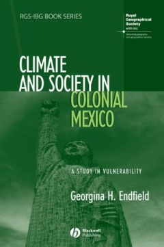
Review of “Climate and Society in Colonial Mexico: A Study in Vulnerability” (Georgina Endfield)

 Books and resources  Comments Off on Review of “Climate and Society in Colonial Mexico: A Study in Vulnerability” (Georgina Endfield)
Apr 052011
 

Environmental historian Georgina Endfield has analyzed a wide variety of colonial archives to explore the complex relationships between climate and social and economic systems. Her book—Climate and Society in Colonial Mexico: A Study in Vulnerability—considers case studies in three distinct zones of Mexico:

  • the arid Conchos Basin of Chihuahua
  • the fertile Oaxaca Valley
  • the agricultural area centered on Guanajuato in the Bajío region

Endfield - Cover of Climate and Society in Colonial MexicoEndfield systematically unravels the connections between climatic vulnerability and the ways in which societies sought to mitigate the impacts of climate-related disasters, while striving for greater resilience against similar events in the future. Her book considers a range of disasters and impacts, from floods, droughts and storms to epidemics, food shortages, riots and rebellions.

The author captures her readers immediately as she describes how “28 June 1692 was a very wet day in Celaya, Guanajuato. Unusually heavy rains began falling in the afternoon and continued all through the evening.” This was the prelude to “terrible panic among all the inhabitants of the city”, and “could not have come at a worse time”, since two years of drought and crop blights had led to famines and epidemics.

Throughout the book’s seven chapters, Endfield writes in a direct manner. She avoids lengthy quotes in favor of presenting a carefully constructed argument, as she leads the reader in an exploration of the content and merits of the colonial sources. In the final chapter, she examines the broader context, relating climatic events in Mexico to events in Europe, and considering the possible role of ENSO (El Niño Southern Oscillation) events.

An extended table towards the end of the book provides a time line for the known environmental hazard events striking the three areas between 1690 and 1820. It shows, for example, that droughts were reported in Chihuahua in no fewer than 40 years of that 130-year time span.

Referencing throughout the book is meticulous, and repeated use is made easier by the provision of a detailed index.

I do have one tiny quibble. The use of accents in this book is quite inconsistent. Even for place names, some accents are missing, while others have migrated to the wrong letter. For example, Léon is often used for León.

This is a fascinating read. Apart from the many invaluable examples of climatic hazards and their demographic, social, economic and political impacts, Endfield has been hugely successful in demonstrating the tremendous value of Mexico’s rich colonial archives, archives which no doubt still hold many more secrets, which they will only give up in response to similarly painstaking research.

Studies of climate change are set to take center-stage in coming decades, and this historical account reminds us all that climate hazards are far from a rare or a novel occurrence.

In short, this is a highly recommendable book.

Details (click for amazon.com):

Climate and Society in Colonial Mexico: A Study in Vulnerability (Blackwell, 2008) by Georgina H. Endfield; 235 pages.

Mexico’s diverse climates and climatic vulnerability are the subject of chapter 4 of Geo-Mexico: the geography and dynamics of modern Mexico. Water availability, rivers, aquifers, water issues and hazards are analyzed in chapters 6 and 7. Buy your copy today!

Can Mexico’s Environmental Agency protect Mexico’s coastline?

 Mexico's geography in the Press  Comments Off on Can Mexico’s Environmental Agency protect Mexico’s coastline?
Mar 242011
 

A case study of the Cabo Cortés tourism megaproject in Baja California Sur
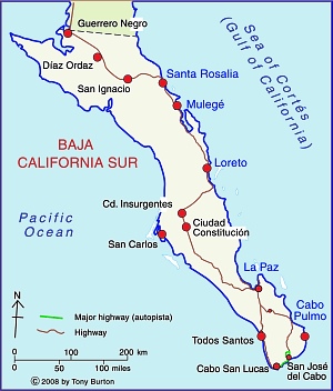
Baja California Sur MapThe Cabo Cortés megaproject is planned for the area near Cabo Pulmo on the eastern side of the Baja California Peninsula. Cabo Pulmo, a village of about 120 people, is about an hour north of San José del Cabo, and on the edge of the Cabo Pulmo National Marine Park.The area is a semi-arid area, where water provision is a serious challenge.

The megaproject is centered on an extensive belt of mature sand dunes which fringe the coast immediately north of Cabo Pulmo.

The megaproject has been in the planning stages for several years, but Mexico’s federal Environment and Natural Resources Secretariat (Semarnat) recently gave Spanish firm Hansa Urbana the green light to begin construction. The controversial plans for Cabo Cortés involve building on the virgin sand dunes, and will undoubtedly have adverse impacts on the small village of Cabo Pulmo and the ecologically-sensitive Cabo Pulmo National Marine Park.

The Semarnat decision provoked the immediate ire of Greenpeace and other environmental campaigners, as well as local residents who fear being displaced from the small village of Cabo Pulmo by a proposed marina.

The value of the Cabo Pulmo National Marine Park

Jacques Costeau, the famous ocean explorer, once described the Sea of Cortés as being the “aquarium of the world.” This area of the Sea has been protected since 1995 and is now designated a National Marine Park. It was declared a “Natural Patrimony of Mankind” by UNESCO in 2005. The protected area, ideal for diving, kayaking and snorkeling, covers 71 sq. km of ocean with its highly complex marine ecosystem. Dive sites include underwater caves and shipwrecks.

The biological productivity of the Marine Park is amazing. Since the National Marine Park was established, the number and size of fish inside the park boundaries have increased rapidly. Studies show that the number of fish has more than quadrupled since 1995, owing to the exceptional productivity of the offshore reef area. The park is an outstanding example of the success of environmental protection efforts.

Cabo Pulmo is on the Tropic of Cancer, about as far north as coral usually grows. The water temperatures vary though the year from about 20 to 30 degrees C (68 to 86 degrees F). The seven fingers of coral off Cabo Pulmo comprise the most northerly living reef in the eastern Pacific. The 25,000-year-old reef is the refuge for more than 220 kinds of fish, including numerous colorful tropical species. Divers and snorkelers regularly report seeing cabrila, grouper, jacks, dorado, wahoo, sergeant majors, angelfish, putterfish and grunts, some of them in large schools.

The tourism megaproject

The project involves an area of 1,248 hectares (3,000 acres). Swathes of land will be cleared for two 18-hole golf courses. Water provision will require the extraction of 4.5 million cubic meters of groundwater a year from the Santiago aquifer, and the construction of 17 kilometers of aqueducts. The planned marina has 490 berths. When complete, the megaproject will offer more than 27,000 tourist rooms, almost as many as Cancún has today, and almost three times as many as currently in nearby Los Cabos. It is estimated that Cabo Cortés will generate 39,000 metric tons of solid wastes a year (about 2 kg/person/day).
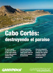
Cover of Greenpeace's position paper on Cabo Cortés

Cover of Greenpeace’s position paper on Cabo Cortés

NGOs oppose Cabo Cortés

When challenged about the legality of granting permission for a project which will impact the Marine Park, Semarnat officials have claimed that the ecological criteria in Semarnat regulations are “suggestive” rather than “obligatory”.

Several NGOs have already launched protest campaigns. Alejandro Olivera is spearheading Greenpeace’s opposition to Semarnat’s decision. He has described the decision as “erroneous” and claims that the megaproject is “not congruent with the prevailing ecological regulations for the region, given that the construction of the marina is in direct contravention of the Los Cabos Ecology Plan which covers this region. The plan expressly prohibits any construction on shoreline dunes. Semarnat maintains that its authorization of a marina and elevated walkways will not affect the “structure or functioning of the area’s sand dune system”.

Olivera emphasizes that Greenpeace is not opposed to tourism as a development strategy, but that it believes in sustainable (responsible) tourism that respects the area’s carrying capacity. Meanwhile, a Greenpeace Spain spokesperson claims that the resort development model of Hansa Urbana, is fundamentally flawed and outdated, and that, when implemented in Spain, it resulted in unacceptable social and environmental costs.

Amanda Maxwell of the Natural Resources Defence Council (NRDC) has written a good summary of why the Semarnat decision should be opposed, entitled “Approval of the Cabo Cortés resort complex–next to the healthiest coral reef in the Gulf of California–is a huge step backward for Mexico

The 120 or so local residents who live in Cabo Pulmo village also oppose the plan and have formed an NGO called Cabo Pulmo Vivo. The existing village, which has no street lights, is a haphazard collection of homes and small businesses, including dive shops, stores and restaurants.

Cabo Pulmo Vivo organized on online petition calling for the Semarnat permits to be revoked.

Personal view, written following a visit in 2008

“We arrive in Cabo Pulmo as the sun is setting, relieved to finally find the end of the initially paved, then dirt, access road, which has been bounded by barbed wire ever since we caught our last clear views of the coast near La Ribera. At intervals behind the barbed wire are warning signs making it very clear that the land either side of the road is private.

Over a beer with Kent Ryan, the owner of Baja Bungalows, our base for the next few days, I learn that the newly erected fences mark the beginning of a major development of the coast immediately outside the National Marine Park. When I eventually got a chance to examine the masterplan, I can only say that I’m glad we visited Cabo Pulmo in early 2008 before this coast is changed for ever.” (Tony Burton in MexConnect)

Further information:

For an exceptionally informative series of papers (in Spanish) on all aspects of tourism and sustainability in Cabo Pulmo,  see Tourism and sustainability in Cabo Pulmo, published in 2008.

Another valuable resource (also in Spanish) is Greenpeace Spain’s position paper entitled Cabo Cortés, destruyendo el paraíso (“Cabo Cortés: destroying paradise”) (pdf file)
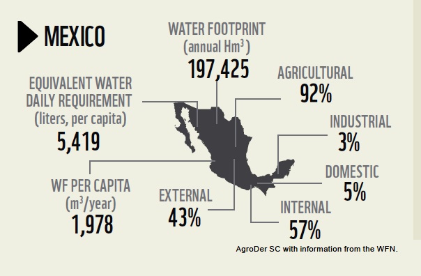
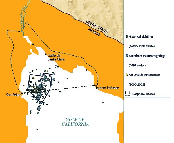
The geography of renewable energy from wind power in Mexico

 Other  Comments Off on The geography of renewable energy from wind power in Mexico
Dec 162010
 

According to the World Association of Wind Power, Mexico grew its wind power sector faster than any other country during 2009, and now has more than 500MW of installed windpower capacity.

Mexico’s goal is to have an installed capacity of 2,500 MW of wind energy by 2012, and to have 26% of the nation’s installed capacity coming from clean energy sources (solar, geothermal, wind, nuclear and large-scale HEP). The Federal Electricity Commission, responsible for the national power grid, is installing two “wind corridors” in Oaxaca to connect several different windpower plants into the grid.

Mexico’s Energy Secretariat recently announced the publication of a new resource of interest to planners and geographers. The Atlas of Wind and Solar power potential is designed to inform investors of the necessary meteorological and climatic background prior to taking significant investment decisions.

According to the Atlas, Mexico’s wind potential is estimated at 71,000 MW. This figure comfortably exceeds the nation’s current installed capacity for all forms of power of 51,000 MW.

The most important single wind-power region in Mexico, and also one of the most important at the global scale is the Isthmus of Tehuantepec, the narrow belt of relatively low-lying land that links the Gulf coast (straddling the Veracruz-Tabasco state boundary) to the Pacific coast in the state of Oaxaca.

La Ventosa wind farm, Oaxaca

La Ventosa wind farm, Oaxaca

Several major wind farms have already been developed in the La Venta section of the Isthmus. Others are being constructed or on the drawing board. For example, Grupo Bimbo (which, with the acquisition of Sara Lee, has become the world’s largest bread- and pastry-maker) announced it is building a wind farm in association with Desarrollos Eólicos Mexicanos (Demex), a subsidiary of Spanish renewable energy firm Renovalia Energy. The “Piedra Larga” wind farm is under construction in Unión Hidalgo, Oaxaca. Costing $200 million, it will have an installed capacity of 90 MW when the first phase is complete, rising to 227 MW when the project is complete. This is sufficient energy to power all Bimbo’s producing and distribution needs in Mexico during the next 18 years at least. The first power will be generated early next year.

Two mining companies are also installing wind farms in Oaxaca, each with an installed capacity of 300MW.

Elsewhere, in Baja California, California-based Cannon Power Group plans is constructing a 1,000MW wind farm in Baja California. The 500 turbines of the 1-billion-dollar Aubanel Wind Project will be located southeast of the town of La Rumorosa, in the mountains between Tijuana and Mexicali. The turbines will supply power to both the USA and Mexico and are a separate project to the 1000MW wind farm planned by Energía Sierra Juárez, a subsidiary of Sempra, for an area north of La Rumorosa.

Currently, Mexico is developing wind power much more quickly than solar power, but this may change in the future, given that much of the country receives between 5 and 6kw/hr/square meter/day in solar energy, which is considerably more than most of the European countries which are now undertaking solar power development.

Related earlier post:

Energy is analyzed in chapter 16 of Geo-Mexico: the geography and dynamics of modern Mexico. and concepts of sustainability are explored in chapters 19 and 30.  Buy your copy today, so you have this handy reference guide to all aspects of Mexico’s geography available whenever you need it.

The sustainable management of Mexico’s natural environment, 2006-2008

 Other  Comments Off on The sustainable management of Mexico’s natural environment, 2006-2008
Nov 062010
 

The IMCO report on the competitiveness of Mexico’s states, which we briefly described in an earlier post, includes a significant section devoted to the sustainable management of Mexico’s natural environment.

IMCO’s sustainable management factor incorporates 14 distinct variables. For almost every variable, the average of all 32 state values for that variable has improved between 2006 and 2008. Only 1 of the 14 variables has worsened, and three have remained unchanged.

photo of garbage

Sadly, not all garbage finds its way into regulated landfills...

The variable that worsened was the proportion of energy derived from “clean” sources, which fell from 18.9% of the total energy produced in 2006 to 17.6% in 2008.

The three variables that remained unchanged were:

  • the surface experiencing drought or aridity
  • the area where soil degradation is a problem
  • and the number of species considered endangered.

The following 10 variables all showed a significant improvement between 2006 and 2008:

  • the annual rate of reforestation, up from 1.1% to 1.7%
  • the number of “environmental emergencies”, down from 11.3 to 10.9
  • the total area formally protected (biosphere reserves, national parks, etc), which increased slightly
  • the value of agricultural production compared to groundwater consumed for agriculture, which also increased slightly
  • the over-exploitation of aquifers, which fell by more than 10%
  • the volume of sewage (wastewater) that is treated, which rose from 859 liters/sec per million inhabitants to 962 liters/sec
  • carbon dioxide emissions which fell to 0.3 parts/million
  • the percentage of all waste entering regulated landfills, which increased from 58% of all waste to 62%
  • a fall in the total generation hazardous wastes
  • an increase in the number of companies certified as “clean”

In addition, the gap between the top-performing state for this factor (Aguascalientes) and the bottom-performing states (Chiapas and Oaxaca) has closed significantly.

Mexico’s environmental trends and issues are examined in chapter 30 of Geo-Mexico: the geography and dynamics of modern Mexico. Ask your library to buy a copy of this handy reference guide to all aspects of Mexico’s geography today! Better yet, purchase your own copy…

The thorny issues of plant and animal trafficking and biopiracy in Mexico

 Excerpts from Geo-Mexico  Comments Off on The thorny issues of plant and animal trafficking and biopiracy in Mexico
Oct 282010
 

In several previous posts we examined the megadiversity of Mexico’s ecosystems which include more than 10% of all the world’s living species.

Mexico’s biodiversity is under pressure from several quarters.

Plant and animal trafficking

Selling wildlife by the roadside in Chihuahua state

Roadside entrepreneurs sell wildlife in Chihuahua state. Photo: Tony Burton; all rights reserved.

Plant and animal trafficking is the country’s third largest criminal activity after illegal drugs and arms smuggling. Favored items include cacti, live birds (some species sell for upwards of $100,000), spider monkeys, sea turtles, snakes and jaguars. Mexico is one of 175 nations that have signed the Convention on International Trade in Endangered Species (CITES) but this has had no discernible effect on the trafficking of flora and fauna.

Biopiracy

Mexico’s megadiversity presents both opportunities, for activities such as ecotourism, as well as challenges such as preventing biopiracy. In its simplest form, biopiracy occurs whenever a bioprospector takes biological material from a place and then acquires a patent or intellectual property rights on it, or one of its constituents, elsewhere. The best documented example of biopiracy in Mexico occurred in 1999 when a US patent was granted to Colorado-based company Pod-ners for the exclusive right to market Enola beans bred from Mexican yellow beans bought only five years previously. Mexico’s bean export business collapsed overnight as shippers were accused of patent infringement. Yellow bean production in Sinaloa fell by 62% in three years.

Mexican growers subsequently proved that the yellow beans they had been breeding for decades are genetically identical to Enola beans but the damage had been done. Subsequently, the patent was challenged by the International Center for Tropical Agriculture. In 2008 the US patent office finally reversed its decision and rejected any patent claims on yellow beans. While this case of biopiracy was thwarted, acts of biopiracy, by their very nature, are usually clandestine and there are certain to be other instances in the future.

This is an excerpt from chapter 30 of Geo-Mexico: the geography and dynamics of modern Mexico. Buy your copy today, and learn more about Mexico’s fascinating geography. The more knowledge you acquire, the more pleasure you will derive from your next trip to Mexico!

The debate over GM corn in Mexico

 Updates to Geo-Mexico  Comments Off on The debate over GM corn in Mexico
Oct 192010
 

Until relatively recently, Mexican authorities have staunchly resisted the introduction of GM corn into the country. Significant improvements in Mexico’s wheat and corn yields have been achieved in the past by long-term programs of selective breeding, such as that which was later dubbed the “Green Revolution“.

In 2009, however, Mexico’s Agriculture and Environment Secretariats approved a project financed by transnational seed firm Monsanto involving 30 hectares of  experimental plots in Sonora, Sinaloa and Tamaulipas planted with transgenic corn. Mexico still does not yet permit the commercialization of genetically-modified corn, but Monsanto has indicated publicly that it hopes that current rules will be relaxed as early as 2011. According to Monsanto, the new seed could boost annual corn production in Mexico by between 6 and 7 million tons, roughly the amount lost each year to disease and pests.

The Monsanto project was been widely condemned by environmental groups. A widely-published article earlier this month by journalist Mica Rosenberg offered an overview of how transgenic (GM) corn is clearly on its way into Mexican mainstream agriculture:

The article is disappointingly superficial in many respects, but does provide a useful starting point for discussions about the relative merits of allowing (or not) commercial imports of transgenic corn seed into Mexico.

As we write in Geo-Mexico, Mexican farmers are well aware of the importance of maintaining genetic diversity:

Mexican farmers share concerns about the on-going loss of genetic diversity, especially in native crops. For example, if all corn farmers planted imported hybrid corn seeds, native diversity would quickly be lost. In Tlaxcala, where about 90% of the corn is grown on non-irrigated land and where two-thirds of farmers grow corn only for their own use, local varieties have been selectively bred by farmers not only for their yields but also because of their color, taste, resistance to pests and ability to withstand strong winds or short-term droughts. Such characteristics are not necessarily important to commercial seed producers.

Events in other countries often have unexpected consequences in Mexico. For example, the price of Mexico’s corn imports from the USA has increased sharply as a result of the high subsidies offered in that country for corn-based biofuel and bio-additives. The rising import price of corn led to an increase in the price of tortillas which adversely affected the poorest sectors of Mexican society.

Furthermore, as we wrote in an earlier post, the Mexican government has shown its support for a major project aimed at ensuring that the genetic diversity of corn is preserved for future generations:

Is the introduction of GM corn into Mexico a good idea? Proponents argue that it will lead to higher yields and reduce losses from pests and diseases. In their view, commercial planting of GM corn in Mexico is inevitable and will help Mexico “catch up” with Brazil and Argentina, where GM crops are already being grown. Opponents argue that it will inevitably reduce the genetic diversity of corn, meaning that corn will have less resilience in future to unexpected (and unpredicted) changes (climate, pests, soil conditions, etc). They also argue that GM corn will make corn growers even more dependent on commercial seed producers.

Greenpeace protest against GM corn

Greenpeace protest against GM corn

At least two studies since 2001 have already found transgenic DNA in fields of native Mexican corn. The first, published in Nature in 2001, reported findings from the state of Oaxaca. One oft-expressed fear is that Monsanto’s fierce protection of its GM corn will lead to the company seeking damages from local farmers who are found to have any GM corn mixed into the native corn growing in their fields, even if this is the result of accidental contamination from neighboring fields where GM crops are being legally cultivated.

Mexico’s agriculture is analyzed in chapter 15 of Geo-Mexico: the geography and dynamics of modern Mexico. and concepts of sustainability are explored in chapters 19 and 30.  Buy your copy today, so you have this handy reference guide to all aspects of Mexico’s geography available whenever you need it.