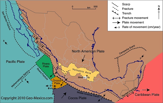
Several previous administrations have tried to decentralize Mexico, encouraging businesses to set up in the “periphery” away from the “core” of Mexico City and central Mexico. The incoming administration has announced its intention to move several federal government Secretariats away from Mexico City. The plans are discussed in some detail in this interesting article by Simon Schatzberg:
Mexico City subsidence and the metro system
Katherine Kornei has just published an interesting account of the recent effects in Mexico City of ground subsidence on the city’s metro system:
Amazing what is possible using satellite technology!
In 2009 Feike de Jong walked the entire perimeter of Mexico City to capture the strange scenery of its fringes. The 800-km trek took him 51 days.
These two Guardian articles tell the story of his trip:
- Cockfights in the edgelands: the man who walked Mexico City’s perimeter
- The very edge of a city: Mexico City’s deepest hinterlands – in pictures
The author’s ebook Limits: On Foot Along the Edge of the Megalopolis of the Valley of Mexico, with the full story and more images, is due to be released later this year.
Enjoy!
Want to learn more about Mexico City?
The geography of Mexico City: index page
This index page has links to our more important posts about Mexico City. Other index pages include:
- Mexican migrants and remittances: an introduction (last update Jun 2016)
- Maps of Mexico on geo-mexico.com (Nov 2015)
- The geography of Mexican farming, agriculture and food production (Jun 2015)
- The geography of Mexico’s drug trade (Sep 2016).
- Mexico’s Indigenous Peoples: an index page (4 Aug 2016)
- Tourism index page (28 Sep 2015)
- The geography of Chiapas (20 Aug 2015)
- 30 top geotourism sites in Mexico (Geo-Mexico special) (May 2015)
Administrative
- Federal District is renamed Mexico City (Feb 2016)
Mexico City background / physical geography / hazards
- The 1985 Mexico City earthquakes: a major disaster (Jul 2011)
- Popocatepetl Volcano puts on an explosive show (Jul 2013)
- Why are some parts of Mexico City sinking into the old lakebed? (Nov 2010)
- How fast is the ground sinking in Mexico City and what can be done about it? (Apr 2012)
- More ground cracks appearing in Mexico City and the Valley of Mexico
- Subsidence incident leads to demolition of 31 homes in the State of Mexico
- Ground subsidence in Mexico City threatens 10,000 homes (Feb 2015)
- The urgent need for reforestation of hills near Mexico City (Jan 2012)
- More problems for residents of Valle de Chalco on the south-eastern edge of Mexico City (May 2011)
Water supply / drainage
- Where does Mexico City get its water from? {May 2013)
- How can Mexico City find sufficient water? (May 2013)
- Mexico City explores deep water aquifer (Dec 2013)
- Test wells being drilled to assess Mexico City’s deep water aquifer (Sep 2014)
- More water meters for Mexico City (Oct 2015)
- Mexico City’s Drinking Water Fountains (Aug 2015
Sewers / Drainage
- Attempts to provide drainage for Mexico City date back to Aztec times (Apr 2011)
- Maintaining the drains and sewers of Mexico City (Jan 2012)
- Mexico D.F. administration offers amnesty to illegal water users (Jul 2011)
- The Eastern Drainage Tunnel: a solution to Mexico City’s drainage problems? (Jan 2012)
Aztecs – Food supply
History / Urban growth / Urban morphology / Housing
- Mexico City in colonial times: 1530–1820
- Battle of Puebla re-enacted each year on Cinco de Mayo (May 5), but in Mexico City
- Quick photo visit to Mexico City (Aug 2014)
- Street patterns in Mexico City
- Santa Fe, a case study of a real estate development on Mexico City’s periphery
- A case study of low-income housing on the urban periphery
- Vecindades, Mexico City’s inner-city slums (Jul 2010)
- Nezahualcoyotl, an irregular settlement which grew into a monster (Jul 2010)
- Informal settlements or “colonias populares” in Mexico’s cities
- Great new site about Mexico City’s Historic Center, but map misses the mark (Jul 2012)
- Micro-businesses help improve the economic and social outlook for irregular settlements (Apr 2011)
- Author David Lida on Mexico City’s transportation systems (Apr 2015)
- Historic photo of the month: Mexico City cave-dwellers (Jul 2015)
- Mexico City chosen over Curitiba (Brazil) as World Design Capital 2018 (Feb 2016)
Megalopolis?
Traffic, taxis and air pollution
- Plans to improve the Mexico City-Toluca transport corridor (Jan 2014)
- Mexico City tackles the challenges of population, commuting and air quality (Aug 2012)
- Traffic congestion still a serious problem for commuters in Mexico City (Sep 2011)
- Mexico City’s “Today you can’t drive” (Day without a Car) program, “Hoy no circula” (Nov 2013)
- Mexico City’s pink taxis: are they a good idea? (Oct 2010)
- Mexico City traffic: short video highlights on-going improvements (Jul 2012)
- Air quality improving in Mexico City but not in Monterrey (Aug 2010)
Metro/subway system
- Mexico City looks to expand its metro network (Dec 2014)
- Line 12, Mexico City’s latest Metro (subway) line (Jan 2103)
- The challenge of building and maintaining Mexico City’s metro system [Nov 2010]
Sustainable Transport / Cable Cars
- New aerial transit system proposed for Mexico City (Sep 2013)
- Will Mexico City add cable cars to its mass transit system? (Apr 2013)
- Passenger cable car for Mexico City (Jan 2014)
- Mexico City wins 2013 Sustainable Transport Award (Jan 2013)
- Mexico City’s Ecobici cycle rental system enters its second year (Feb 2011)
- Mexico City’s Ecobici cycle rental system enters its fifth year (Feb 2014)
Airport
- A new airport for Mexico City (Sep 2014)
Urban revitalization
- The on-going transformation of Mexico City [May 2011]
- The revitalization of Mexico City’s historic downtown core [Aug 2010]
Other
- Recycled plastic boats for Xochimilco? (Oct 2014)
- Mexico City’s wholesale food market, Central de Abasto (Jul 2010)
- Bringing place names to life in Mexico City (Aug 2010)
- Mexico City has largely escaped drug violence (Mar 2012)
- Updates on the geography of Mexico City (Mar 2011)
- Updates on the geography of Mexico City (Dec 2010)
- Recent news briefs related to the geography of Mexico City (Oct 2010)
Map of Mexico City urban system:
Spatial growth of Mexico City Metropolitan Area:
Locations in Valley of Mexico with high incidence of ground cracks:

Locations in Valley of Mexico with high incidence of ground cracks. Cartography: Tony Burton; all rights reserved.
General posts about Mexico’s urban geography
- Mexico’s urban hierarchy (May 2015)
- The distinctive sounds of Mexico’s towns and cities (Aug 2010)
- Are Mexico’s large cities growing faster than small cities? (Jun 2011)
- Have big cities in Mexico succeeded in meeting people’s needs? (Sep 2013)
- Mexico’s urban air pollution remains the worst in Latin America (Aug 2013)
- Several Mexican cities rank among the American Cities of the Future (Apr 2013)
- What is the elevation of Mexico’s cities? (Feb 2013)
- The changing climate of Mexico’s urban areas (Dec 2011)
- Mexico’s major metropolitan areas and cities, 2010
- The impact of NAFTA on urban growth in Mexico (Jun 2010)
Mexico City declares public markets to be Intangible Cultural Heritage
Mexico has some of the finest markets in the world. The variety of produce and other items sold in markets is staggering. But not all Mexican markets are the same. The two major groups are the permanent markets (mercados), usually housed in a purpose-built structure and open for business every day, and the street market or tianguis, usually held once a week.
Earlier this month, Mexico City passed legislation that gave the city’s 329 public markets Intangible Cultural Heritage status, and provided additional funding to ensure that their traditional activities are maintained for future generations.
Some of the markets are traditional, mixed markets, others are specialized. Between them, they are used on a regular basis by almost half of Mexico City’s residents and provide more than 280,000 jobs. The Mexico City commission established to preserve these traditional spaces and their practices has been allocated a budget in 2017 of $200,000,000 pesos (about $11 million).
Beyond their regular role as a trading place, many of the markets in Mexico City have additional claims to fame. For example the La Paz market in Tlalpan in the southern part of the city occupies an architecturally impressive building, while the Abelardo L. Rodríguez market in the downtown area has fine decorative murals painted by students of Diego Rivera.
Related posts:
Mexico City chosen over Curitiba (Brazil) as World Design Capital 2018
At its 29th General Assembly in Gwangju, South Korea, a few months ago, the International Council of Societies of Industrial Design (ICSID) announced that Mexico City has been designated World Design Capital (WDC) 2018. Mexico City is the first city from the Americas to hold the designation.
ICSID President Professor Mugendi M’Rithaa stated, “Mexico City will serve as a model for other megacities around the world grappling with the challenges of urbanization and using design thinking to ensure a safer, more livable city.”
The WDC is awarded every second year to cities that are committed to using design as an effective tool for economic, social, and cultural development. Previous designated cities include Torino (Italy) in 2008, Seoul (South Korea) in 2010, Helsinki (Finland) in 2012, Cape Town (South Africa) in 2014, and Taipei this year, 2016.
The bid was led by Design Week Mexico, a non-profit organization that promotes design as an engine of social change. Design Week Mexico intends to focus its actions on the borough of Miguel Hidalgo, introducing new health, communications and security programs, a bike sharing program, urban gardens, parks and playgrounds. Emilio Cabrera, Director General of Design Week Mexico said, “Our goal is to build a platform for collaboration not only between design disciplines, but also between countries. As WDC, we seek to create a hub of global creative industries that have an impact on their societies.”
The Mexico City bid was preferred over a rival bid from Curitiba (Brazil), well known for its innovative approach to urban sustainability.
For access to more than sixty articles about all aspects of the geography of Mexico City, see The geography of Mexico City: index page.
Related posts:
- The challenge of building and maintaining Mexico City’s metro system
- Mexico City tackles the challenges of population, commuting and air quality [Aug 2012]
- Mexico City wins 2013 Sustainable Transport Award[Jan 2013]
- How can Mexico City find sufficient water? (May 2013)
- Thirty years ago: the 1985 Mexico City earthquakes, a major disaster
- Historic photo of the month: Mexico City cave-dwellers
Federal District is renamed Mexico City
The name “Distrito Federal” (Federal District) has been replaced by “Ciudad de México” (Mexico City). This is bad news for cartographers who need to relabel all those maps that say “Mexico D.F.”! The abbreviated form for the city’s name in Spanish will be CDMX.
The constitution for the new administrative entity, which will eventually enjoy full status as a state, will be drawn up by a group of 100 citizens (to be elected in June), expected to include some members of the federal Chamber of Deputies.
Among other advantages, the change of status means that Mexico City will no longer need federal approval when selecting its police chief and attorney general. Administration of Mexico City’s 16 delegaciones (boroughs) will change from borough chiefs and regidores to mayors and councils.
Mexico City will remain Mexico’s capital city and the seat of the federal administration. No changes are planned for the neighboring Estado de México (State of Mexico). The Mexico City Metropolitan Area (MCMA) includes Mexico City, but also extends well into adjacent areas of the State of Mexico.
Want to learn more?
For access to more than sixty articles about all aspects of the geography of Mexico City, see The geography of Mexico City: index page.
Line 12 of Mexico City’s Metro (subway) system was originally opened in October 2012. The new line, also known as the Golden Line, extended the city’s metro system into several lower income areas in the south-eastern part of the city, including Tlahuac, Milpa Alta, Xochimilco and Iztapalapa.
However, in March 2014, the elevated (above ground) 14-kilometer-long (9 mi) southern section of this line between Tlahuac and Atlalilco stations was closed for emergency repairs. A replacement bus system was established between those stations. According to a report in the Mexico City daily Reforma (citing a study by ILF Consulting Engineers), the design of tracks in that section had resulted in damage to the wheels of several metro trains. It also resulted in the failure of an electric cable and caused cracks and fractures in the track supports. Authorities have blamed some former city officials, together with the line’s builders, a consortium comprised of France’s Alstom and the Mexican companies ICA and Carso.
Metro Line 12 was finally fully reopened 20 months later, on 29 November, 2015. Line 12 is the longest line in the city’s metro network,extending 25 km (15.5 miles), with 20 stations, including four transfer points. In terms of network connectivity, it added an important east-west link connecting four lines that serve the southern section of the metro area. Line 12 runs from Mixcoac (Line 7) to Tlahuac in the southeast of Mexico City, intersecting with line 3 at Zapata, line 2 at Ermita and line 8 at Atlalilco.
Officials estimate that the line, which has both underground and overground sections, eliminates 860 buses from the city’s congested streets, reducing carbon dioxide emissions by 22,000 metric tons a year. It cost about $1.8 billion to construct.
Between 400,000 and 450,000 passengers are now expected to use Line 12 daily. It is expected to cut the average daily commuting time from those parts of the city it serves by more than an hour a day, from 150 minutes to 78 minutes. The line is only accessible by using the new metropolitan smart transport card “Tarjeta DF”.
The complete network of 12 lines comprising Mexico City’s metro system, used by more than 5 million passengers a day, now has 195 stations and a total length of about 227 km (141 miles).
Will the line eventually be extended?
In January 2013, officials of Mexico City’s Metro system (Sistema de Transporte Colectivo, STC) announced that they were considering extending Line 12 westwards into the Álvaro Obregón district of the city. This is still being talked about. STC’s Managing Director Joel Ortega Cuevas also said that an analysis was needed of the viability of extending the Metro network to reach several major commuting routes in the State of México (see map), including Ecatepec-Coacalco-Zumpango; Chalco-Ixtapaluca; Naucalpan-Tlalnepantla-Cuautitlán; Atizapan-Naucalpan and Chimalhuacan-Nezahualcóyotl.
Useful links:
- Map of Mexico City metro system, including Line 12 (png image file)
- Map of Mexico City metro system (official printable system map, pdf file)
Related posts:
- The challenge of building and maintaining Mexico City’s metro system
- Why are some parts of Mexico City sinking into the old lakebed?
- How fast is the ground sinking in Mexico City and what can be done about it?
- Traffic congestion still a serious problem for commuters in Mexico City [Sep 2011]
- Mexico City tackles the challenges of population, commuting and air quality [Aug 2012]
- Mexico City wins 2013 Sustainable Transport Award[Jan 2013]
More water meters for Mexico City
A recent OOSKAnews report says that Mexico City’s water authority (Sacmex) is seeking to purchase 27,835 more water meters that it plans to install in coming months. Sacmex supplies water to around 2 million separate addresses, of which 1.4 million are already metered. The latest purchase is part of Sacmex’s plan to ensure that 100% of connections to the water system are metered. Sacmex’s current budget includes $3.5 million for an additional 40,000 meters.
At present, users without a meter pay a fixed bi-monthly tariff based on the building category, and intended type of water use (domestic/industrial/commercial).
Funding for the meters will be part of a $200 million World Bank-supported “Program to Improve the Efficiency of Operating Organizations” (PROME) which has already financed various projects across the country for urban areas with populations over 20,000. Projects already funded by the Progam include more efficient pumps, the updating of user databases with geo-referencing technology, and studies to gauge the robustness of indicators such as water pressure, water quality and leak detection.
Sacmex is also working on other distribution issues. Earlier this year – see Water in Mexico: a human right that is currently subsidized and wasted – Sacmex CEO Ramón Aguirre Diaz said that the agency required $430 million to combat leakages in the system (currently estimated at around 40% of supply), and claimed that a long-term program to fix the problem would be introduced next year.
Related posts:
- Where does Mexico City get its water? (May 2013)
- How can Mexico City find sufficient water? (May 2013)
- Test wells being drilled to assess Mexico City’s deep water aquifer
- Mexico City’s Drinking Water Fountains (Aug 2015)
- Mexico D.F. administration offers amnesty to illegal water users
- Which cities have the best and worst water systems in Mexico?
- Mexico’s major cities confront serious water supply issues
Thirty years ago: the 1985 Mexico City earthquakes, a major disaster
The worst earthquake disaster in modern Mexican history occurred thirty years ago this week. On Thursday 19 September 1985 a magnitude 8.1 earthquake struck at 7:19 a.m. and lasted a full two minutes. It was followed by a 7.5-magnitude earthquake 36 hours later.
These earthquakes resulted from the Cocos Plate (see map) pushing under the North American Plate. While the epicenters were 50 km off Mexico’s Pacific coast, near the Michoacán-Guerrero border, most of the damage occurred 350 km (215 mi) away in Mexico City because the city center’s subsoil, being former lakebed, is very unstable. The clay and silt beneath the city is up to 50 m thick in the area that received most damage. Geologists have likened the effects of the earthquake to the shaking of a bowl of jelly.
Further damage was caused by liquefaction, a process in which water is squeezed rapidly through the pore spaces in soil, dramatically reducing its cohesion. The sediments beneath Mexico City amplified the ground motions during the earthquakes and many buildings were stressed well beyond building code limits.
Damage estimates range upward to 10,000 deaths, 50,000 injured and 100,000 homeless. More than 500 buildings collapsed, and a further 600 of the 3000 damaged structures were subsequently razed to the ground. The destruction was concentrated in a relatively small area near the city center and included many public buildings, such as government offices, as well as 11 hospitals and clinics, numerous multi-story apartment blocks, 11 hotels and 10 banks. More than 1600 school classrooms were damaged.
Buildings of between 6 and 15 stories were especially hard hit. The underbelly of the city was exposed; dozens of textile sweatshops were destroyed. The damages revealed many instances of poor construction standards and of poor enforcement of building codes. Well-built high rises such as the Latin American tower, designed to be earthquake-proof, were unscathed.
The total cost to the Mexican economy was estimated to exceed $5 billion, equivalent to 2% of the country’s GDP (Gross Domestic Product).
The disastrous 1985 earthquakes led to much tighter building codes, equal or superior to anywhere in the world, and to the formation of well-trained emergency search and rescue brigades. They also resulted in the establishment of a Seismic Alarm System which provides a 50-second warning for any earthquake measuring over 6.0 on the Richter scale occurring off the coast of Guerrero or Michoacán.
This is an excerpt from chapter 2 of Geo-Mexico: the geography and dynamics of modern Mexico. Many more details of Mexico’s geology and landforms are analyzed in other parts of the book; take a look using Amazon.com’s Look Inside feature before buying your copy today!
Related posts:
- Which tectonic plates affect Mexico?
- How has the movement of tectonic plates affected Mexico?
- Major earthquake strikes Guerrero and Oaxaca states (20 Mar 2011)
- Two major earthquakes jolted western Mexico (11/12 Apr 2012)
- 7.2 earthquake in Guerrero shakes Mexico City and central Mexico (18 Apr 2014)
- 6.9 magnitude earthquake strikes Chiapas and Guatemala (7 Jul 2014)
- Was this fissure near Hermosillo caused by subsidence or by faulting?