Tourism index page

 Index page  Comments Off on Tourism index page
May 232017
 

This Tourism index page lists the most relevant posts on Geo-Mexico related to tourism, including history of tourism in Mexico, types of tourism, major resorts, and current trends. It is updated periodically.

Importance of tourism:

History of tourism in Mexico, hotels, publicity campaigns:

Magic Towns:

Cancún and the Riviera Maya (Maya Riviera), Quintana Roo:

Huatulco and Oaxaca:

Acapulco:

Geotourism and ecotourism in Mexico:

Cruise ships:

Lake Chapala, Ajijic, Chapala and the Lerma-Chapala basin:

Megaproject proposals and conflicts over tourism:

Specialized forms of tourism (tourism niche markets):

Other (miscellaneous):

Other Geo-Mexico index pages:

Hidden Beach, aka Beach of Love, reopens

 Mexico's geography in the Press  Comments Off on Hidden Beach, aka Beach of Love, reopens
Sep 012016
 

Mexico’s famed Hidden Beach (Playa Escondida), aka as the Beach of Love (Playa del Amor), has reopened for limited tourism following a three month closure  for cleaning and restoration work.

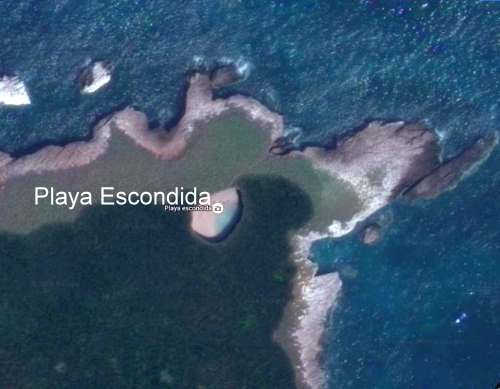
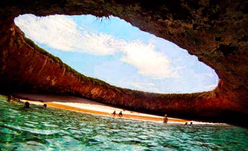
The beach is on one of the small, uninhabited Marieta Islands, in the Marieta Islands National Park, off the west coast of Mexico, and relatively close to the resort of Puerto Vallarta. It is one of Mexico’s most beautiful small beaches, looking from the air (image) like an “eye to the sky”.

Playa Escondida. Source: Google Earth. Scale: The beach is about 30 m (100 ft) long.

Playa Escondida. Source: Google Earth. Scale: The beach is about 30 m (100 ft) long.

In earlier posts, we considered how Playa Escondida (“Hidden Beach”) was formed and also looked at the not inconsiderable downside to publicizing one of Mexico’s most beautiful beaches.

After a study by University of Guadalajara researchers found that local coral was dying and argued that the beach could support no more than 625 visitors a day (compared to the estimated 2500 who visit it on vacation days), federal authorities closed the beach and prohibited access while they considered how best to regulate future visits.

Mexico’s National Protected Areas Commission (Conanp) has now announced new regulations governing visits to the island and to the beach. It is limiting visitors to 116/day, well below the University of Guadalajara figure for carrying capacity of 625/day/.

In addition, no single group may have more than 15 members. No diving is allowed. Fins, face masks and snorkels are all prohibited. Visits have a strict time limit of 30 minutes. The beach, visted by more than 125,000 in 2015, will be completely closed two days each week for maintenance and monitoring.

Only time will tell if these measures will be sufficient to ensure that this particular gem of Mexico’s hundreds of amazing geosites will still be there for future generations to admire and appreciate.

Related posts

Aug 182016
 

Despite having seen this tourist promotion logo thousands of times, I had never thought about its colors and their significance until recently.

mexico tourism logoIt turns out that the colors (despite what you may see on your monitor) are actually meant to be:

  • M – brown = archaeology and archaeological sites (historical tourism)
  • é – pink = health and well-being (including medical tourism)
  • x – yellow = culture (cultural tourism)
  • i – purple = meetings (seminars and conference tourism)
  • c – green = nature (adventure tourism and ecotourism)
  • o – blue = sea, sun and sand (beach and resort tourism)

The federal Tourism Secretariat is planning a nationwide overhaul of tourism signage on major highways taking advantage of these colors. It will install new, standardized signs using these six colors as a quick means of identifying the kind of tourist attraction at each location of interest. The program has funding of almost $10 million, and the first states to have the new signs will be Chiapas, Durango, Guanajuato, Hidalgo, Jalisco, Michoacán, Puebla, Tabasco, Tlaxcala and Veracruz.

Whether or not using six different colors is actually more effective than six distinct symbols on the same color background remains to be seen.

In the first half of this year, Mexico received 17,000,000 international tourists, 8.6% more than for the corresponding period in 2015, with expenditures by tourists rising 8% to $10.063 billion.

Related posts:

How was Playa Escondida (“Hidden Beach”) formed?

 Other  Comments Off on How was Playa Escondida (“Hidden Beach”) formed?
Jun 022016
 

Following on from our look at the potentially disastrous environmental consequences of publicizing Playa Escondida (“Hidden Beach”), one of Mexico’s most beautiful small beaches, we take a look at how this extraordinary beach was formed.

Playa Escondida. Source: Google Earth. Scale: The beach is about 30 m (100 ft) long.

Playa Escondida. Source: Google Earth. Scale: The beach is about 30 m (100 ft) long.

Playa Escondida is on one of the small, uninhabited Marieta Islands, in the Marieta Islands National Park, off the west coast of Mexico, and relatively close to Puerto Vallarta.

playa-escondida

The beach is an “eye to the sky” and is aptly described by travel writer Brandon Presser, as follows:

At the center of Isla Redonda [is] a quirk of nature seen only on the pages of a fantasy novel—a sandy beach carved into the rounded core of the island like the hole of donut. Although completely invisible from the shoreline, a bird’s eye view reveals lapping crystal waters and an empty dune like dazzling colors at the end of kaleidoscope’s funnel.”

The Marieta Islands are formed of volcanic rocks and are an extension of Mexico’s Volcanic Axis.

Just how was this beach formed? Prosser describes two alternative suggestions. The first is that the volcanic rocks were not uniform in composition and hardness but had differences in resistance to subaerial weathering and erosion. According to this theory, the weaker, less consolidated rocks were eroded more quickly than the surrounding rocks to leave a giant chasm in the ground. This chasm was then breached on one side by marine action.

The alternative theory mentioned by Prosser, and the only one mentioned (though without citation) by wikipedia, is that the chasm was formed by human activity, specifically by the Mexican military who undertook bombing practice in and around the islands prior to when the area was given National Park status.

Coastal geomorphologists might argue the case for considering a third theory, involving the formation, first, of the cove on the outer coast of the island, followed by a combination of marine and subaerial action to exploit a line of weakness in the volcanic rocks to create a landform known as a geo (a narrow, deep, cleft extending inland from the coast). This geo may have gradually lengthened over time, by continued cave formation at the head of the geo, with marine erosion at the back of the cave opening up a blowhole, a small opening to the sky. A sequence of collapses and blowhole formation, over time, may have created Playa Escondida, where the interior beach is the base of a former blowhole, where the roof has collapsed and the material subsequently removed by marine action or pounded into beach sand.

Whatever the explanation, this particular geomorphosite is one of Mexico’s many natural treasures, and one well worth preserving for future generations.

Related posts

Community-based ecotourism in La Ventanilla, Oaxaca: success or failure?

 Other  Comments Off on Community-based ecotourism in La Ventanilla, Oaxaca: success or failure?
Jun 182015
 

Ecotourism at La Ventanilla on the coast of Oaxaca, a small community of about 100 inhabitants, located between the beach resorts of Puerto Escondido and Puerto Angel, began more than twenty years ago. It is based on trips run by local guides through the mangroves lining a lagoon on the Tonameca River; the area’s wildlife includes iguanas, birds, crocodiles and sea turtles.

The main local cooperative that conducts tours is called Servicio Ecoturisticos de La Ventanilla (La Ventanilla Ecotourism Services). Income from its tours supports reforestation and other ecological projects, including a greenhouse for mangrove reforestation and a nursery to hatch and raise crocodiles for release on Uma Island, in the lagoon. A breakaway co-operative, Cooperativa Lagarto Real, also runs some local excursions, though its profits do not contribute to local conservation efforts.

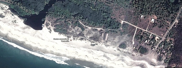
La Ventanilla (Google Earth)

La Ventanilla (Google Earth)

Most visitors to La Ventanilla come only for the day; the small local community offers only limited services or accommodations for tourists. The community of La Ventanilla is often held up as a shining example of how a well-implemented “assistive conservation” ecotourism approach can combine environmental conservation with economic sustainability, while enhancing the local quality of life.

But is this apparent success story quite as idyllic as usually portrayed in the mainstream press? Dr. David Vargas-del-Río, a researcher at ITESO in Guadalajara, sets out to explore this question in his recent article, “The assistive conservation approach for community-based lands: the case of La Ventanilla”, published in the December 2014 issue of The Geographical Journal. The article is based on Vargas-del-Río’s doctorate thesis at the UPC University, Barcelona.

As Vargas-del-Río explains, “The assistive conservation approach includes strategies for conserving community-based lands based on a complex combination of traditional and modern scientific knowledge. It enjoys broad legitimacy and seems promising for conserving territories with autochthonous populations. However, as a novel strategy, it has been applied mostly to societies and environments that are fragile in conservationist terms.”

The author explores how there has been a gradual shift in the protection of natural areas from ‘top-down’ to ‘bottom-up’ models of environmental management, before turning to his case-study of La Ventanilla. La Ventanilla lends itself to such a case study since an assistive conservation approach was first implemented there more than twenty years ago, More than sufficient time to allow for some follow-up evaluation. His eventual conclusion is that while assistive conservation approaches sound good in theory, they may, over time, make local ecologies “more vulnerable to social and environmental degradation, especially as traditional management institutions once responsible for ecological integrity become obsolete”.

In reviewing the background literature, Vargas-del-Río asserts that there are “three broad critical currents” of criticism of the assistive conservation approach. These include the potential adverse impacts of utilizing protected areas for tourism. The provision of attractions, installations and other services, leads to “new dynamics, impacts and transformations” in terms of tourism providers, and may result in “competition between local actors and powerful tourism agents, both conventional and emergent.” Potential issues include changes in local consumption and behavior patterns, and the view that nature and local culture are commodities.

Just how was this manifested in the context of La Ventanilla?

Initial effects of the assistive conservation approach in La Ventanilla were positive. Restrictions were placed, and enforced, on “activities considered ‘disruptive’; that is, hunting, selling local species, harvesting turtle eggs, and felling mangrove trees…”The cooperative soon won praise for its environmental responsibility and received more funds from the government to conduct volunteer conservation projects, including reforestation in the mangroves, a deer reserve, a turtle egg nursery, and areas for iguanas, among other initiatives. Hence, it continued to receive financial and moral power which it exercised over the rest of the population, while promoting conservation and tourism over traditional uses.”

Following extensive fieldwork in the community, Vargas-del-Río found, “a marked tendency towards spatial segregation, social fragmentation, inequality and speculation; phenomena that have emerged as a direct result of the ‘conservation’ initiative with its nature-based tourism activities and imposed environmental restrictions.”The La Ventanilla Ecotourism Services Cooperative (CSELV) is “controlled by six local leaders who own the lands where the cooperative’s main assets are located, handle all accounts, and elaborate support and funding applications.” Other members of the co-operative are “simple wage earners”.

Inequality triggered by the project led to segregation, in terms of housing quality, in the central area of the community. A group of nine disgruntled members of the initial co-operative, broke away in 2004 and founded a second co-operative, Lagarto Real. They “disregarded the management plan”, “sabotaged some conservation and ecotourism initiatives undertaken in this sub-zone, and set up restaurants, shops and camping sites of their own that lacked the ‘green’ image that others were marketing.” The growth of ecotourism has led to land speculation, including a controversy over the construction and (illegal) sale of a small hotel built on communal property.

The island of Uma is controlled by the original co-operative and no longer accessible for traditional activities such as agriculture. There has been a dramatic shift in economic activities. “Agriculture and fishing are now practiced by just 7% of inhabitants and represent an important source of income for only 10.7% of households. In contrast, tourism-related activities occupy 34.7% of the people, represent 70.1% of the economically active population, and are the main source of income for 67.9% of households.”

Vargas-del-Río concludes that previous assessments failed “to take into account slow, gradual changes”. One outcome has been “a higher risk of land degradation in social and environmental terms as the local society fragments, inequality increases, more actors (external and local) strive to profit from the territory, and regulation becomes more difficult.”

In conclusion, “assistive approaches modify ways of approaching nature, restrict traditional uses in favour of tourism, weaken local management institutions and degrade environmental and social relations.” The assistive approach “undermines the cultural, economic and local environment while creating new spaces for consumption.”

Source:

David Vargas-del-Río, 2014. “The assistive conservation approach for community-based lands: the case of La Ventanilla”, The Geographical Journal, Vol. 180 #4 (December 2014) 377–391.

Related posts:

Mexico’s geomorphosites: Peñas Cargadas, Mineral del Monte, Hidalgo

 Other  Comments Off on Mexico’s geomorphosites: Peñas Cargadas, Mineral del Monte, Hidalgo
Apr 232015
 

This short Postandfly video of an area known as Peñas Cargardas (“Loaded Rocks”) in the state of Hidalgo is the perfect excuse to add to our posts about Mexico’s geomorphosites – sites where landforms have provided amazing scenery for our enjoyment. This area of Mexico is definitely one of my favorites, partly because it is crammed with interesting sights for geographers, including the Basalt Prisms of San Miguel Regla, only a few kilometers away from the Piedras Cargadas, and an equally-stunning geomorphosite.

A few minutes east of the city of Pachuca, the Peñas Cargadas (sometimes called the Piedras Cargadas) are located in a valley in the surrounding pine-fir forest. The rocks comprising the Peñas Cargadas have capricious shapes; some appear to be balanced on top of others. Their formation may well be due to the same processes that formed the Piedras Encimadas in Puebla, which are actually not all that far away as the crow flies.

The nearest town, Mineral del Monte (aka Real del Monte) has lots of interest for cultural tourists. Among many other claims to fame, it was where the first soccer and tennis matches in Mexico were played ~ in the nineteenth century, when the surrounding hills echoed to the sounds of Cornish miners, brought here from the U.K. to work the silver mines.

The miners introduced the Cornish Pasty, chile-enriched variations of which are still sold in the town as pastes. Real del Monte also has an English Cemetery, testament not only to the many tragic accidents that befell miners when mining here was at its peak, but also to the long-standing allegiance that led many in-comers to remain here to raise their families long after mining was in near-terminal decline. The town has typical nineteenth century mining architecture. The larger buildings retain many signs of their former wealth the glory.

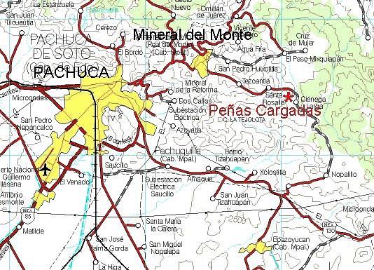
pachuca-map

The following Spanish language video has some ground-level views, as well as more information about the scenery and the area’s flora:

How to get there

The Peñas Cargadas are about ten kilometers east of Pachuca (see map). From Pachuca, follow signs for Mineral del Monte, and then drive past the “Panteón Inglés” (English Cemetery) in that town on the road to Tezoantla. The Peñas Cargadas are about 3.5 kilometers beyond Tezoantla. This is a great place for a day trip from Mexico City.

Related posts:

Nov 132014
 

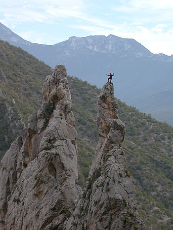
Mexico’s varied geography has made it a premier destination for all kinds of adventure tourism, from caving and canyoneering to jungle treks, white-water rafting and rock climbing.

This 6-minute video shows mountaineer Alex Honnold climbing the 460-meter (1500-feet) high rock face known as El Sendero Luminoso near Monterrey in northern Mexico. What makes this climb special (and slightly scary to watch) is that Honnold climbs solo and without any safety measures such as ropes.

Interviewed for National Geographic Adventure before he had seen the video, Honnold said, “I’m not sure what the video shows, but my true solo was all alone with no photogs [photographers] or helis [helicopters]. We then went back and filmed on big portions of it. In my mind there’s a clear difference between personal climbing—the actual solo—and work days—the filming afterward.”

"The Spires" in El Potrero Chico climbing area (Wikipedia photo)

“The Spires” in El Potrero Chico climbing area (Wikipedia photo)

The El Sendero Luminoso rockface is in an area known as El Potrero Chico, a short distance from Monterrey, near the town of Hidalgo.

The Wikipedia entry for El Potrero Chico describes it as having “a large range of different climbs, most of them in the 5.8 to 5.13 grade. The type of climbing can range from steep overhanging face to easy slab. The rock is usually quite sharp. The climbs are mostly situated in a canyon at the entrance of the park, while the interior offers undeveloped mountain terrain with many mountain biking routes, ranging from very easy to expert options.”

According to Wikipedia, El Potrero is “considered one of the top 10 locations to sport climb in the world. In addition to well over 500 routes, the area boasts the second longest sport route in North America, Timewave Zero, with 23 pitches and over 2,000 feet (610 m).”

Related posts:

Oct 112014
 

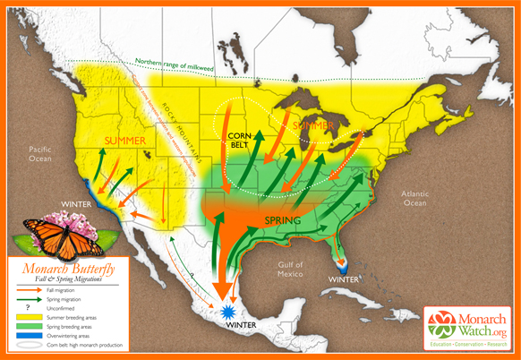
Most monarch butterflies never migrate, but one generation of the North American monarch population undertakes an annual, long distance migration, a journey without parallel in the insect world. Every winter, some one hundred million monarch butterflies fly south into Mexico from the U.S. and Canada. They congregate and spend the winter in a dozen localities high in the temperate pine and fir forests of the states of México and Michoacán.

Where do the Monarchs overwinter?

The exact sites where the butterflies overwinter were only found in the mid 1970s after a search of nearly forty years. Scientists are still unable to explain all the details of this enigmatic annual migration, but their unexpectedly sophisticated navigational ability seems to rely on an incredible innate accuracy in pinpointing their position by using their eyes and antennas to measure the angles of the sun’s rays, compensating for time of day, and ensuring they continue to fly in a southerly direction towards the state boundary separating Michoacán from the State of México.

How fast can they fly?

The tagging of butterflies has proven that they make the 2500 kilometer trip each way at an impressive average speed of 20 km/h, with maximum speeds of up to 40 km/h (25 mph). Monarchs don’t fly at night, partly because they need daylight to navigate and partly because they fly best when sunlight has warmed their wings, like miniature solar panels, raising their body temperatures some 10 to 15 degrees Celsius above ambient air temperatures.

The butterflies are energy-efficient flyers, making regular nectar stops along the way to refuel. One third of their dry body weight is energy-giving fat but far from losing weight on their exhausting journey south, they actually appear to gain it! There are still many mysteries about the monarchs but they certainly provide one of the most amazing natural spectacles to be seen anywhere on earth. Millions of orange butterflies, with black and white-spotted wings, whether flying overhead or, as on cooler days, clinging apparently lifeless to the grey-green fir trees in such numbers that the trees appear to be in blossom, are an absolutely unforgettable sight.

Based on original map design created by Paul Mirocha (paulmirocha.com) for Monarch Watch.

Based on original map design created by Paul Mirocha (paulmirocha.com) for Monarch Watch.

The journey south

In September and October, as temperatures in the U.S. and Canada fall, and food supplies become scarce, the monarchs fly south in small groups. Some of these groups fly only as far as Florida or western California where they spend their winters in milder conditions. But many of the small groups from east of the Continental Divide eventually coalesce and fly much further south, as far as Mexico, arriving en masse in the state of Michoacán towards the end of November.

This migratory group is comprised of as many as 120 million individuals and spends the winter in semi-dormancy, on the pine and oyamel (sacred fir, Abies religiosa) trees found at elevation of about 3050 meters (10,000 feet) along Mexico’s central Volcanic Axis. Until spring comes, in March or April, these butterflies cling to the branches and trunks of the trees, enjoying temperatures between 10 and 16 degrees Celsius, protected from cold northerly winds. Their metabolism slows down in these low temperature, low oxygen conditions and they exhibit movement only on warm, sunny, days.

The generation that flies into Mexico does not mature sexually until the following spring. In February and March, the best months to see them, early spring sunlight begins to penetrate the groves of fir trees, temperatures begin to rise and the forest floor slowly comes alive with new plant growth. The butterflies, having successfully overwintered the worst weather, unfurl their wings and flutter about in search of food and water. As they regain their strength, so they become sexually mature and the mating process starts.

The journey north

After mating, the butterflies begin to leave the reserves, flying back towards the north. Five days later, in northern Mexico and the southern U.S., each female lays two to three hundred eggs on the underside of milkweed leaves. They first check (by smell and touch) that no eggs have already been laid there, and then space their eggs in such a way so as to ensure that each larva that hatches two to three days later will have an adequate supply of food. The larvae grow quickly, changing their skins five times before becoming pupae. After a further two weeks, butterflies emerge, and fly northwards. Each generation of monarchs probably acquires a different chemical “blueprint”, based on the exact species of milkweed it eats, giving it the information it needs to know where to fly. Eventually, by April, the northernmost butterflies reach Canada.

No individual butterfly completes the entire 5000 kilometer round trip. Most of those that fly south die soon after mating in spring (with males often dying in the reserves and never starting their homeward trip), while those who head north cannot hope to survive long into the summer, when normal reproductive cycles, each lasting from four to six weeks, are reestablished.

The last generation of each summer, perhaps prompted by shorter days, soon departs on the next wave of mass migration to Mexico. Those from furthest north will cross the Great Lakes on their return in a single day’s flight, an impressive feat in its own right. They have been spotted flying south at heights up to 1500 meters and exploit thermals to gain height and save energy.

Where to see Monarch Butterflies

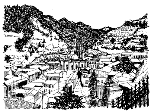
Several monarch reserves are open to the public each year. Each has its own distinctive character. Two of the most important reserves are close to the town of Angangueo. Sierra Chincua, north of the town, is the site where the first Canadian-tagged monarch was found in the mid 1970s. This is also where I first saw the butterflies, in 1980, while looking for a potential site for geography fieldwork. It was a serendipitous discovery, and led to me being mistaken for a BBC reporter, but that’s another story!

Angangueo. Sketch by Mark Eager; all rights reserved.

Angangueo. Sketch by Mark Eager; all rights reserved.

The most accessible reserve open to the public is El Rosario, south of Angangueo, where there are dozens of souvenir stalls and rustic snack stands—don’t miss sampling the delicious hand-made blue-corn tortillas. The narrow trails in the sanctuary, with information boards at regular intervals, wind steeply several hundred meters uphill, reaching a maximum altitude of 3050 meters. This altitude can cause some shortage of breath and air temperatures are generally low, so be sure to bring a sweater.

El Rosario can be reached from either Angangueo (steeper but more direct approach) or Ocampo. Anyone driving their own vehicle to El Rosario is advised to use the route via San Felipe (on Highway 15) and then Ocampo. From Ocampo any vehicle with adequate ground clearance, including the local taxis, can negotiate the fourteen kilometers to the monarch sanctuary parking lot.

The San Felipe-Ocampo junction on Highway 15 is marked by a line of fruit and soft-drink stalls, many of which in season sell delicious granadas (pomegranates). Also at this junction is an interesting sixteenth century church which, until as recently as 1995, had tombstones in its atrium, unusual in Mexico. Normally, the Spanish buried their dead as far away from the churchyard as possible, presumably to avoid the risk of disease.

Want to read more?

This post is based on chapter 36 of my “Western Mexico: A Traveler’s Treasury” (link is to Amazon’s “Look Inside” feature), also available as either a Kindle edition or Kobo ebook.

Related posts:

Back to the drawing board for US-Chinese tourism project near Cabo Pulmo

 Mexico's geography in the Press  Comments Off on Back to the drawing board for US-Chinese tourism project near Cabo Pulmo
Jun 232014
 

Good news for Cabo Pulmo, the marine park in Baja California Sur! Cabo Pulmo is a 7,111-hectare (17,550-acre) marine reserve that boasts the best-preserved coral reef in Mexico’s Pacific region. The proposed tourist megaproject known as Cabo Dorado on the edge of the park has been shelved, at least for now.

The US-Chinese joint venture behind Cabo Dorado said it is halting plans to build the tourist development due to the “well-founded” criticism of environmental groups. [See New threat to Cabo Pulmo National Marine Park] The $3.6 billion project was to have included construction of thousands of hotel guestrooms in the area where another giant development project, Cabo Cortés, had been planned. The Cabo Cortés project was cancelled by government officials on the grounds of environmental concerns.

The firms behind Cabo Dorado are Glorious Earth Group (USA) and Beijing Sansong International Trade Group (China), together with China State Construction Engineering Corporation. The initial proposal was for a project involving the construction of a new “ecotourist city” on 3770 hectares (9317 acres) of land, including 6,141 homes,9 hotels, 2 golf courses, a landing strip, shops and a convention center.

The group has now halted its initial environmental-impact study of the Cabo Dorado project, with the intention of resuming this procedure in the near future with a new project “that meticulously takes into account the well-founded criticisms that have been expressed and which we’ve listened to carefully and with the utmost respect”.

Related posts:

The landforms of the El Pinacate and Gran Desierto de Altar Biosphere Reserve

 Other  Comments Off on The landforms of the El Pinacate and Gran Desierto de Altar Biosphere Reserve
Nov 092013
 

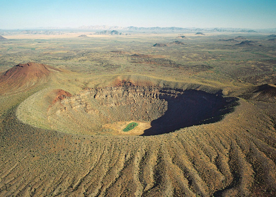
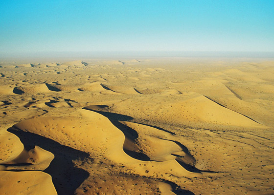
The breathtaking scenery of the El Pinacate and Gran Desierto de Altar Biosphere Reserve in the northern state of Sonora affords visitors a dramatic combination of two very distinct landscape types: volcanic landscapes (El Pinacate) in the east, and sand dunes (Gran Desierto de Altar) towards the west and south.

pinacate-map-googleVolcanic scenery (El Pinacate)

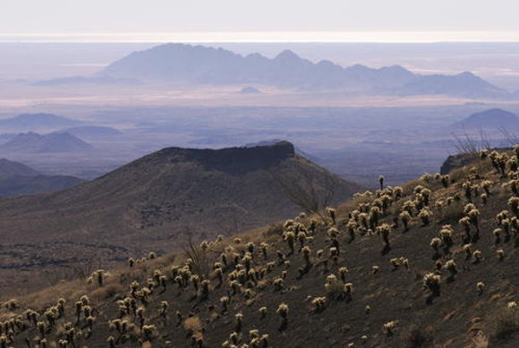
The eastern section of the Biosphere Reserve, El Pinacate, is a dormant volcanic area of around 200,000 ha (2000 sq. km), centered on the El Pinacate Shield (or Sierra Pinacate) which has 3 main peaks: Pinacate, Carnegie and Medio. The El Pinacate Shield is a composite structure, comprised of extensive, successive black and red lava flows, some more than 20 km long, seperated by desert pavement. The El Pinacate Shield boasts a wide array of volcanic phenomena and geological formations. Most of the lava is basaltic (alkaline) in composition, making it relatively fluid when molten; it is mainly of the aa (blocky) type, though some pahoehoe (ropy) lava is also found. The total volume of lava is estimated at between 150 and 180 km3.

Elegante Crater, El Pinacate

Elegante Crater, El Pinacate (example of a maar) Credit: IUCN Tilman Jaeger

Besides the lave flows, the Pinacate area has more than 400 cinder cones (formed 1.2 million years ago) and several lava tubes. The lava flows and cinder cones are only a prelude to the most visually striking features in the reserve: 10 enormous, deep, and almost perfectly circular maars (steam explosion craters). Maars are believed to originate from a combination of explosion caused by groundwater coming into contact with hot lava or magma and subsequent collapse. The maars of El Pinacate are rivalled only by similar formations in Africa. The largest single maar is El Elegante, formed 32,000 years ago, which is 1,400 meters (4,600 feet) from rim to rim and 140 meters (460 feet) deep. It takes visitors a two to three-hour hike to reach its rim and be rewarded by a spectacular view.

The volcanic forms of El Pinacate are relatively recent in geological terms, most having been formed during the Quaternary Period, which began some 2.8 million years ago. The most recent volcanic activity in this area was only about 11,000 years ago. Some volcanologists believe that some of these craters could become active again in the future, with the potential to form volcanoes up to a few hundred meters in height.

Ron Mader, the founder of Planeta.com and a foremost authority on responsible tourism in Mexico, has marveled at the “bizarre and mind-boggling scenery” of El Pinacate., which so resemble the lunar landscape that between 1865 and 1970 it was used by NASA as a training ground for astronauts preparing for the moon landings. The lava field is so vast and sharply defined that it later turned out that the astronauts could easily recognize it from space!

Sand dunes (Gran Desierto de Altar)

The western and southern parts of the El Pinacate and Gran Desierto de Altar Biosphere Reserve have entirely different scenery. The Gran Desierto de Altar is North America’s largest field of active sand dunes (erg). Several types of dunes are represented here, the tallest reaching 200 meters in height.

The sand needed to form and maintain these dunes comes from the fluvial and deltaic sediments of the Colorado River delta (to the west), the beaches of the Sea of Cortés/Gulf of California (to the south), the River Sonoyta (to the east) and the smaller river and stream fans formed in those parts of the reserve where there are volcanic and granitic mountains.

Sand dunes of Gran Desierto de Altar

Sand dunes of Gran Desierto de Altar

Prior to the opening of the Sea of Cortés (Gulf of California), vast amounts of sediment accumulated in this region brought by rivers of which little trace remains today. The creation of the Sea of Cortés, 5.3 million years ago, shortened the rivers and increased their average gradient (rejuvenation), causing them to cut into the pre-existing landscape leaving behind river terraces, remnants of the former higher level floodplains.

The fields of sand dunes of the Gran Desierto de Altar cover more than 550,000 hectares (5700 sq.km.) Several different kinds of sand dunes are found here–linear, crescent-shaped (barchans) and star-shaped–and they can be simple, compound or complex, depending on seasonal changes in the direction and strength of the wind.

Although linear dunes dominate (70%), crescent-shaped complex dunes and star-shaped dunes are of more interest because they exist in only a few locations in the world. Spectacular and very large star-shaped dunes, up to 200 meters high, occur both singly and in long ridges up to 48km in length. Star-shaped dunes possibly evolved from crescent dunes which changed their direction of movement becoming “reversing dunes”. Side winds may account for the multiple arms of some star-shaped dunes.

Other features – Granite massifs

In addition, there are several granite massifs (inselbergs), such as the Sierra del Rosario, emerging like islands from the sandy desert flats and dunes. They range in elevation from 300 to 650 meters above sea level. They represent another remarkable landscape feature harboring distinct plant and wildlife communities.

Main source:

Related posts:

Oct 242013
 

Mexico’s latest UNESCO World Heritage Site is the El Pinacate and Gran Desierto de Altar Biosphere Reserve in Sonora, added to the UNESCO list in June 2013. Mexico now has 32 World Heritage Sites.

The El Pinacate and Gran Desierto de Altar Biosphere Reserve is part of the Sonoran desert, which extends from Sonora into the northern part of Baja California, and across the U.S. border into Arizona and California. The reserve covers 714,566 hectares with an additional 354,871 hectares of buffer zone. It is a relatively undisturbed portion of the Sonoran desert, and offers visitors a dramatic combination of two very distinct landscape types: volcanic landscapes (El Pinacate) and sand dunes (Gran Desierto de Altar).

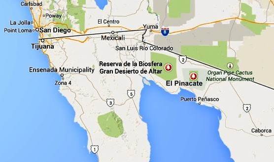
pinacate-map-googleThe biosphere reserve is immediately south of the U.S. border, west of the Lukeville (Arizona) – Sonoyta (Sonora) border crossing, and 50 km (30 miles) north of the fishing and tourist town of Puerto Peñasco. The San Luis Río Colorado–Sonoyta section of Mexican federal highway 2 (which runs from Mexicali to Caborca) skirts the northern section of the reserve. Puerto Peñasco is connected to Sonoyta by highway 8. There are entrances to the park from highway 2, 50 km west of Sonoyta, and from highway 8, mid-way between Sonoyta and Puerto Peñasco.

Despite being a desert area, most parts of the biosphere reserve do receive occasional rainfall, which gives this area more biodiversity than is true for most deserts.

El Pinacate and Gran Desierto de Altar Biosphere ReserveVaried scenery

The eastern section of the biosphere reserve, El Pinacate, is a dormant volcanic area of around 200,000 ha (2000 sq. km), centered on the El Pinacate Shield (or Sierra Pinacate) which has lava flows, cinder cones, lava tubes and circular maars (steam explosion craters). Ron Mader, the founder of Planeta.com and a foremost authority on responsible tourism in Mexico, has marveled at the “bizarre and mind-boggling scenery” of El Pinacate. The geology and landforms of this area so resemble the lunar landscape that between 1865 and 1970 NASA used it as a training ground for astronauts preparing for the moon landings. The lava field is so vast and sharply defined that it later turned out that the astronauts could easily recognize it from space!

The western and southern parts of the El Pinacate and Gran Desierto de Altar Biosphere Reserve are entirely different. The Gran Desierto de Altar is North America’s largest field of active sand dunes (erg), more than 550,000 hectares (5700 sq.km.) in area. Several types of dunes are represented here, the tallest reaching 200 meters in height, including linear, crescent-shaped (barchans) and star-shaped dunes.

Flora and Fauna

The highly diverse mosaic of habitats in the biosphere reserve is home to complex communities and a surprisingly high species diversity. More than 540 species of vascular plants, 44 mammals, more than 200 birds and over 40 reptiles inhabit this seemingly inhospitable desert. All feature sophisticated physiological and behavioural adaptations to the extreme environmental conditions. Insect diversity is high, though not fully documented. Several endemic species of plants and animals exist, including two freshwater fish species.

The flora in Sierra Pinacate includes the sculptural elephant tree (Bursera microphylla). The name “Pinacate” derives from pinacatl, the Nahuatl word for the endemic desert stink beetle. The biosphere reserve has large caves inhabited by the migratory lesser long-nosed bat (Leptonycteris curasoae yerbabuenae), which is an important pollinator and seed dispersal vector, and the endangered fish-eating bat (Myotis vivesi); both species are endemic.

Other noteworthy species in the reserve include the threatened Sonoran pronghorn (Antilocapra americana sonorensis), an endemic subspecies of restricted habitat and the fastest land mammal in North America; bighorn sheep (Ovis canadensis mexicana), the mule deer (Odocoileus hemionus) and gray fox (Urocyon cinereoargenteus), the Gila monster (Heloderma suspectum) and desert tortoise (Gopherus agassizii).

Human occupation and use

El Pinacate and Gran Desierto de Altar contains numerous archaeological remains, some dating back more than 20,000 years. It is an important cultural site for the indigenous Tohono O’odham people who consider El Pinacate peak, where they still perform sacred ceremonies, as the place where  creation occurred.

Management issues

The El Pinacate section of the biosphere reserve was first designated a “protected area” in 1979. In 1993, it was a declared a Biosphere Reserve, along with the Gran Desierto de Altar, by then president Carlos Salinas de Gortari. The biosphere reserve is managed by Mexico’s National Commission of Natural Protected Areas (Conanp), in collaboration with the Sonora state government and the Tohono O’odham people.

The number of people visiting the reserve has risen rapidly from fewer than 6,000 in 2000 to more than 17,500 in 2010. The two major challenges that management needs to take into account are how to ensure that indigenous views about the reserve’s use are respected, and how to limit negative impacts on the reserve from nearby tourism developments.

The potential negative impacts include:

  • increased vehicle traffic, resulting in ecological disturbance, littering and wildlife road kills.
  • pressure to extend the limited existing road infrastructure by adding new roads, though this might lead to more exotic (alien) invasive species.
  • increased habitat damage from the growing use of off-road vehicles

UNESCO considers that, “The most critical long term management issue is to address potential problems derived from tourism-related water consumption.”

Given that this reserve is on the Mexico-U.S. border, transboundary cooperation is essential, and UNESCO actually recommends that the best way forward is to establish a Transboundary Protected Area, extending into Arizona.

The combination of a volcanic shield with spectacular craters and lava flows, almost entirely surrounded by an immense sea of dunes, makes this an area of great scientific interest, and an ideal laboratory for researchers interested in geology and geomorphology.

[Note: This post makes extensive use of UNESCO’s description of the biosphere reserve, with additional information from a variety of other sources.]

Want to read more?

Related posts:

Mexico’s geomorphosites: the Primavera Forest, Guadalajara, Jalisco

 Other  Comments Off on Mexico’s geomorphosites: the Primavera Forest, Guadalajara, Jalisco
Jun 012013
 

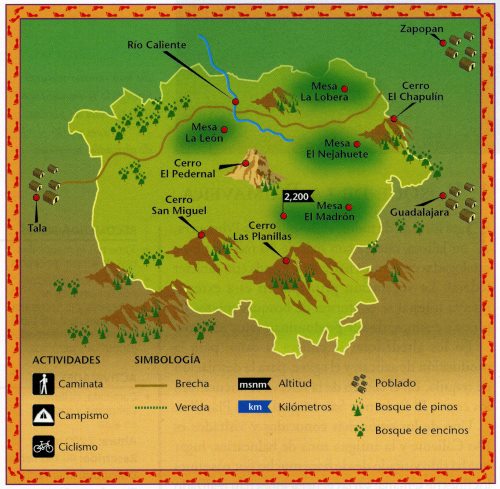
The Primavera Forest (aka Bosque de la Primavera, Sierra de la Primavera) is a volcanic region located immediately west of Mexico’s second-largest city, Guadalajara. The Primavera Forest occupies an ancient volcanic caldera, where the last eruptions are thought to have been about 30,000 years ago. The Primavera is a wilderness area of pine and oak woodland, with hot-water rivers, nature-trails and thermal spas. The park, which is about 30 km (19 mi) across (see map), serves as the lungs of Guadalajara and is popular, especially on weekends, for activities such as picnics, birdwatching, hiking, climbing, mountain biking and motocross.

The Primavera Forest. Credit: Semarnat, 2003

Basic map of the Primavera Forest. The distance between Tala and Guadalajara is about 35 km (22 miles). Credit: Semarnat, 2003

The main geographic and geological attractions of the Primavera Forest include:

Scenery, views, flora and fauna

The average elevation of the Primavera Forest is about 2200 m above sea level, rising to 2270 m (7447 ft) towards the eastern edge of the forest which overlooks the city of Guadalajara. The three main summits are El Pedernal, San Miguel and Las Planillas. There is easy access to the 30,000 ha of protected natural area from various points, including the town of Tala and from Highway 15 (the main Guadalajara-Tepic highway) which skirts the northern edge of the Primavera. Agriculture and settlement have made incursions into the edges of the park, with land cleared for subdivisions or for fields of sugarcane and agave (for tequila). A major wildfire raged through parts of the forest in 2012.

The park is home to about 1000 different plant species as well as 137 different birds and at least 106 terrestrial animals, including deer, puma, opossums (tlacuaches), armadillos and rabbits.

Hot springs

Thermal springs are common throughout the Volcanic Axis of Mexico, and the hot river and many hot springs in the Primavera Forest are a legacy of its volcanic history. Río Caliente, the main developed spa in the Primavera Forest, famous for several decades as one of the country’s top vegetarian and health spas, closed in 2011, following some years of uncertainty regarding its land tenure status and increasing security concerns because of its relatively remote location.

The hot springs in the park have been subject to numerous exploratory studies by the Federal Electricity Commission (CFE) which considers the park a potential source of geothermal power. The CFE drilled a dozen wells in the 1980s, finding that six of them offered sufficient flow for power production. The CFE believes the park could support at least three 25 megawatt geothermal plants. Drilling was suspended between 1989 and 1994 when the Jalisco state government ordered the CFE to carry out environmental restoration to areas damaged by drilling activities, and the plants have not yet been approved.

Pumice deposits

As veteran explorer-author John Pint points out in “A geopark in my back yard?”, the Primavera Forest is well known to geologists for its giant blocks of pumice, up to several meters across, which are among the largest found anywhere in the world. One of the best locations for seeing these is in the 50-meter-high walls of the Río Seco arroyo on the northern edge of the park, on the outskirts of the small community of Pinar de la Venta. The cliff face has a thick band of pumice overlying numerous thin layers of lake sediments. The pumice blocks are highly vesicular (full of holes) and therefore surprisingly light for their size.

Obsidian deposits

The Primavera Forest is also well known to geologists (and archaeologists) because it has significant amounts of obsidian, a hard, glassy, usually black rock. Obsidian is easy to find (often in big chunks) in several parts of the park. The obsidian formed when blocks of hot lava, still molten, rained into the cold waters of a lake, cooling instantaneously. When fractured, pieces of obsidian acquire very, very sharp edges. Even today, some surgeons still prefer obsidian scalpel blades, recognizing that they are far sharper than those made from even the best steel.

Obsidian was in great demand in precolonial times for use as mirrors, arrowheads and knives, as well as jewelry:

“Among the people to prize obsidian were the residents of Iztépete (often spelt Ixtépete), “hill of obsidian or knife blades”, located just outside the eastern edge of La Primavera. This small, largely forgotten, and poorly-signed archaeological site in a southern suburb of Guadalajara is within a stone’s throw of the city’s periférico (ring-road).”

“Large, angular chunks of obsidian litter the slopes of Cerro Colli, the hill rising behind the 6-meter-high pyramid, which conceals at least five earlier pyramids, each superimposed over the one before. Ceramics found here suggest that occupation stretches back at least to the fifth century, but little is known about the people who built this site.”  [Quotes are from the recently published 4th edition of the author’s “Western Mexico, A Traveler’s Treasury”]

Obsidian is found throughout this region, and while usually black in color, it can also be found in a range of hues, including red and even rainbow patterns. Not far from the western edge of Primavera, at the foot of a steep-sided knoll called El Picacho is El Pedernal, reputed to be the largest obsidian deposit in the world, covering 4 square kilometers, from which an astonishing 40,000 cubic meters of rock have been extracted over the centuries. Sophisticated chemical techniques have shown that El Pedernal obsidian was widely used in Mesoamerica, finding its way as far north as California and as far south as Oaxaca!

The pre-Columbian obsidian jewelry from this region, consisting of very thin wafers of rock, is unique to this area, and clearly the work of highly skilled specialist craftsmen. One particularly fine example (now in the museum in Tala) is a necklace fashioned out of wafer-thin obsidian carvings of human figures, each pierced by a tiny hole. In the absence of metal tools, the patience and dexterity required to have made these is truly amazing.

The art of obsidian carving has not been lost. Skilled artisans in Navajas, another nearby village, continue to this day to chip and shape chunks of obsidian into spheres, chess boards and beautiful works of art, often representing animals.

In future posts we will consider the formation of the La Primavera Forest in more detail, and also look at the extent to which the pressures resulting from its proximity to the city of Guadalajara threaten the park’s long-term health.

Want to read more?

John Pint is one of those spearheading the proposal of seeking UNESCO designation for La Primavera as a GeoPark.

U.S. Peace Corps Volunteer and geologist Barbara Dye has written a beautifully-illustrated  72-page guide (in Spanish) to the geology of the Primavera Forest: “La Apasionante Geología del Área de Protección de Flora y Fauna La Primavera”.

Related posts:

Mexico’s geomorphosites: El Sótano de las Golondrinas (Cave of the Swallows)

 Other  Comments Off on Mexico’s geomorphosites: El Sótano de las Golondrinas (Cave of the Swallows)
Apr 112013
 

El Sótano de las Golondrinas, in the municipality of Aquismón in the state of San Luis Potosí, is a massive limestone sinkhole (pit cave), one of the largest known in the world. In terms of depth, it is thought to be the second deepest sinkhole in Mexico and is probably in the world’s top 20.

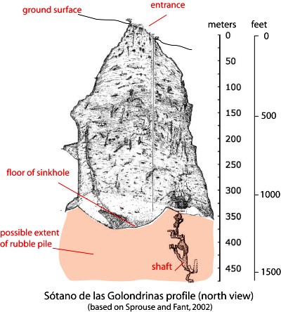
The depth of sinkholes can be difficult to determine. For example, in the case of El Sótano de las Golondrinas, its surface opening is about 50 meters by 60 meters (160 by 200 ft) in size, but is on a slope. The depth on the high side is about 376 meters (1220 ft); the depth on the low side is about 330 meters (1090 ft).

sotano-de-las-golon

Below the surface (see profile) the sinkhole is roughly bottle-shaped. The floor of the sinkhole is about 300 x 135 meters (990 by 440 ft) in area. However, the sinkhole is believed to have formed from the collapse of the roof of an underground cave. As a result, the floor of the sinkhole is not solid rock but rubble that presumably came from the walls and former roof. A shaft on one side extends down at least another 100 m, suggesting that the true floor of the original cave lies at least that far beneath the current rubble-strewn floor.

US photographer Amy Hinkle shot some spectacular images earlier this year in this cave.  The accompanying article highlights the “secret garden” that “nestles 300 meters beneath the surface of the earth”.

The cave’s name (literally “basement of the swallows”) derives from the thousands of white-collared swifts that inhabit the overhanging walls of its interior. They spiral out of the cave every morning over a period of 25-30 minutes and return to their cave homes close to sunset. Large numbers of green parakeets also live in the cave.

The floor of the sinkhole is home to a rich plant life, as well as a diverse selection of  fungi, millipedes, insects, snakes, and scorpions.

The original cave is thought to have been formed by a lengthy period of water erosion along a major fault line in the lower Cretaceous limestone in the Sierra Huasteca (part of Mexico’s Eastern Sierra Madre). Over time, the cave became larger as a consequence of both the water erosion and due to mass movements (landslides, rockfalls) on its walls. Eventually, the size of the cave was so large that its walls could no longer support its roof which then collapsed into the cave, leaving the open air sinkhole seen today. Following heavy rain, short-lived waterfalls cascade down the sides of the sinkhole.

The first documented exploration of El Sótano de las Golondrinas was apparently in 1966. Since that time, the cave has become a popular destination for various adventure sports including rappelling, abseiling and base jumping (no longer allowed).

There are several other very deep sinkholes in the same general area, including Hoya de las Guasguas (with a 202 m deep entrance shaft) and Sótano del Barro (402 m in depth).

Some ornithological studies have found that the bird population of El Sótano de las Golondrinas is decreasing, perhaps due to the disturbance caused by the increasing number of human visitors. To limit disturbance, access and activities are more tightly controlled. For instance, descents into the cave are now strictly limited to daylight hours when the birds are absent, and a no-fly zone has been established around the cave, primarily to avoid helicopter disturbance.

El Sótano de las Golondrinas is yet another outstanding example of a geomorphosite in Mexico. Mexico has literally thousands of geomorphosites. Among those described in previous Geo-Mexico posts are:

References:

Related article:

Magic Towns #58-62: Chiapa de Corzo, Comitán de Domínguez, Huichapan, Tequisquiapan, Batopilas

 Mexico's geography in the Press  Comments Off on Magic Towns #58-62: Chiapa de Corzo, Comitán de Domínguez, Huichapan, Tequisquiapan, Batopilas
Oct 252012
 

Well… the spate of Magic Town nominations shows no sign of slowing down. The federal Tourism Secretariat has announced that it hopes to have 70 towns in the program before the new administration takes office in December. The latest five additions to the list of Magic Towns are:

#58 Chiapa de Corzo, Chiapas

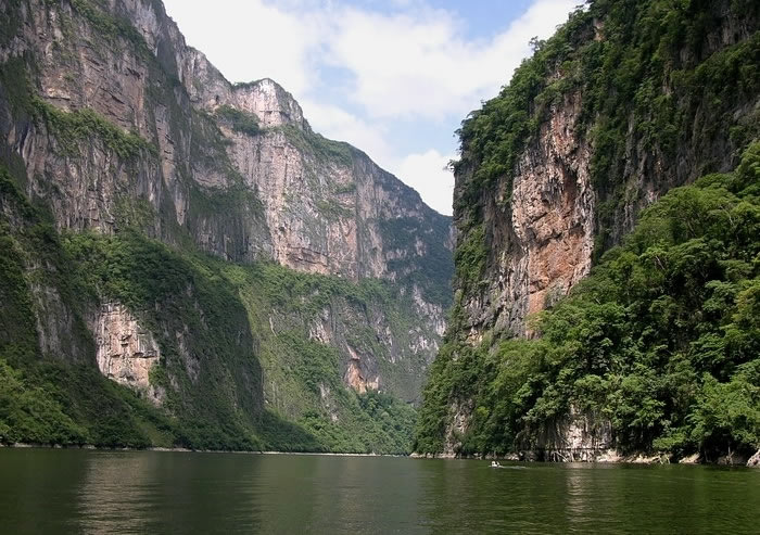
Chiapa de Corzo is a small city (2010 population:  45,000), founded in 1528, located where the PanAmerican Highway (Highway 190) from Oaxaca to San Cristobál de las Casas crosses the River Grijalva, 15 km east of Tuxtla Gutiérrez, in the state of Chiapas. It is the site of the earliest known Mesoamerican tomb burial and has considerable archaeological significance. The massive La Pila fountain, dating from 1562, is one of the most distinctive structures anywhere in Mexico. The town has more than its share of historical interest, including the well-preserved 16th century Santo Domingo church/monastery and a museum dedicated to traditional lacquer work (a local craft). It is best known to tourists as the main starting point for boat trips along the Grijalva River into the Sumidero Canyon National Park.

Sumidero Canyon National Park

Sumidero Canyon National Park

#59 Comitán de Domínguez, Chiapas

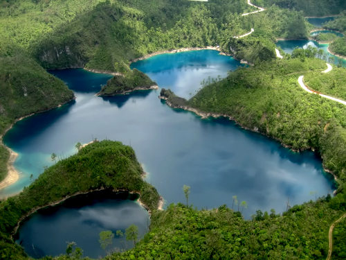
Comitán is a town of about 85,000 people, south-east of San Cristobál de las Casas, and close to the border with Guatemala. The town attracts mainly Mexican tourists on their way to the Lagunas de Montebello National Park and several remote Mayan archaeological sites in the border zone.

Lagunas de Montebello National Park

Lagunas de Montebello National Park

#60 Huichapan, Hidalgo

Huichapan has some interesting history and architecture, but relatively little to interest the general tourist. (Even Wikipedia has little to say about this town!)

#61 Tequisquiapan, Querétaro

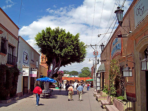
This very pretty town has already been described in several previous posts on geo-mexico.com, including:

Tequisquiapan

Tequisquiapan

#62 Batopilas, Chihuahua

Designated in mid-October 2012. This small town, situated at an elevation of 501 meters above sea level, on the floor of the picturesque Batopilas Canyon, in Mexico’s Copper Canyon region, was once an important silver-mining center. The great German explorer, Alexander von Humboldt called Batopilas the “metallic marvel of the world”. Some of the old buildings in Batopilas have been restored in recent years. Still in ruins is the former dwelling of Alexander Robert Shepherd, one-time Governor of the District of Colombia, USA.

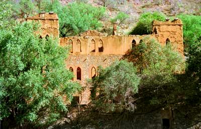
Ruins of former Shepherd mansion, Batopilas

Ruins of former Shepherd mansion, Batopilas

In 1880, Shepherd moved here, complete with family, friends, workers, dogs and grand-piano. His son, Grant Shepherd, describes in his book, The Silver Magnet, how this piano, the first ever seen in this part of Mexico, was carried overland more than 300 km in three weeks by teams of men, each paid the princely sum of US$1.00 a day for his efforts! Shepherd lived here for thirty years, running a silver mine and entertaining stray foreigners who passed through. He employed English servants. When the Mexican Revolution began, he abandoned Batopilas and the mansion fell into ruins. Shepherd is said to have mined more than US$22 million worth of silver here; he was behind the amalgamation of all the mines into a single company, the Consolidated Batopilas Mining Co. in 1887.

Related posts:


Oct 012012
 

Mexico currently has 65 Magic Towns (Pueblos Mágicos), some of which we have described in previous posts. Regular readers will know we have some reservations about the program, especially about the inclusion on the list of some places that have relatively little to attract the average tourist.

Are Magic Towns distributed evenly across the country?

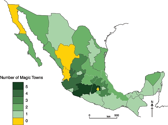
The map shows the distribution of the 57 Magic Towns, by state, as of 1 October 2012. Magic Towns are clearly not evenly distributed across Mexico. Two states – the State of México and Michoacán– each have five Magic Towns, while Jalisco has four. It is no surprise that the Federal District (México D.F.) is not designated a Magic Town, but it is a surprise that there are no Magic Towns in Baja California, Durango or Nayarit. Mexcaltitán, an island town in Nayarit, was one of the first towns in Mexico to be designated a Magic Town, but had this status revoked in 2009.

Mexico's Magic Towns, by state (September 2012)

Mexico’s Magic Towns, by state (September 2012)

Southern Mexican states appear to be drastically underrepresented, especially when area of state, population and indigenous groups are taken into account.

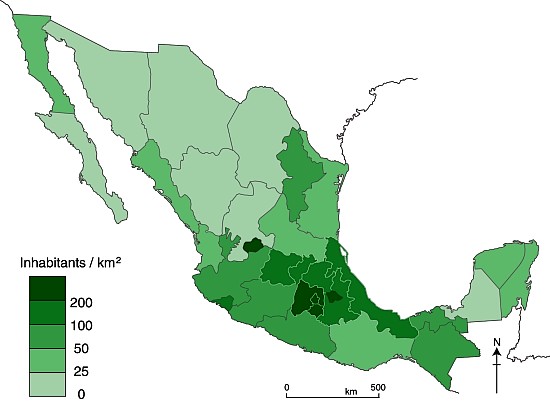
Population density map

Mexico’s population density in 2010

Larger states (in area and/or population) would surely  be more likely to have more Magic Town candidates. However, it is clear from comparing the maps of Magic Towns and population density (above) that the number of Magic Towns does not appear to be related to either the area of states, or to their population density.

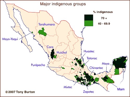
The major indigenous groups in Mexico

The major indigenous groups in Mexico

Indigenous groups are relevant because they tend to live in relatively remote areas of great natural beauty, such as the Copper Canyon region or the Huasteca, and they also exhibit many distinctive cultural traits, giving them a head-start in the race to demonstrate their attractiveness for tourism. Again, though, there is little common ground between the map of indigenous groups and the map of Magic Towns. In particular, the states of Guerrero, Oaxaca and Campeche all seem to have fewer Magic Towns than might be expected.

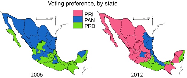
Voting patterns in presidential elections, 2006 and 2012

Voting patterns in presidential elections, 2006 and 2012. All rights reserved.

Even politics does not appear to help explain the distribution of Magic Towns, though it must be pointed out that the pattern of voting for presidential elections (maps) may not match the pattern of municipal voting which would be more relevant to applications for Magic Town status.

If and when more towns are added to the Magic Towns list, perhaps the reasons for their distribution will become more obvious.

This post examined the distribution of Mexico’s Magic Towns, as of 1 October 2012, at which point there were only 57 in total. Since this post was written, additional Magic Towns include:

There is no doubt that Mexico has many other places that would be very worthy additions to the list. Which places would you add?

Related posts:

Jul 052012
 

By virtue of its geography, the Gulf coast state of Veracruz is one of the best places in the world to see the annual migration of birds of prey (raptors) from North America to Central and South America.

Between 4 and 6 million birds (eagles, hawks, vultures, falcons, and kites) make this trip each way each year to trade the harsh winter and scarce food in one hemisphere for better conditions in the other hemisphere. The migration south takes place September-November, and the return migration passes overhead in March-April.

Since most raptors are relatively large birds, and they are accompanied by other species such as storks, white pelicans and anhingas, this annual migration is one of the most awesome birding spectacles anywhere in the world. Each passing flock contains tens of thousands, in some cases hundreds of thousands, of individuals.

The raptors fly during daylight and rest overnight. Their New World songbird cousins, who also migrate in vast numbers, prefer to feed and rest during the day and then fly at night. Most songbirds take a direct migration route from the eastern USA to Central and South America, flying directly over the Gulf of Mexico in a “single, epic 18-hour flight”. Raptors, on the other hand, prefer a more leisurely approach, leap-frogging along the coastal plain.

Why do they fly through Veracruz?

The main reasons are:

1. Relief: Mexico’s mountain ranges, especially the Sierra Madre Oriental {Eastern Sierra Madre) and Volcanic Axis, funnel the birds towards the east coast, but the Gulf of Mexico provides a natural barrier preventing the birds from attempting routes further to the east. At its narrowest, this funnel is only 25 km (15 miles) wide.

2. Climate: The wide coastal plain warms up sufficiently to provide ascending thermal “bubbles” which help keep these large birds aloft and minimize  the energy expenditure required to soar and fly large distances. Raptors use the thermals to soar to about 1000 meters (3000 feet) above the ground, before gliding in their desired direction of travel gradually losing height until they pick up another thermal at a height of about 300 meters (1000 feet), repeating the process as often as needed. On a good day, they will cover more than 320 km (200 miles) in this fashion before resting for the night.

3. Biogeography: The varied landscape, vegetation and animal life in habitats ranging from tropical wetlands to temperature forests, offers plenty of potential food sources for the raptors.

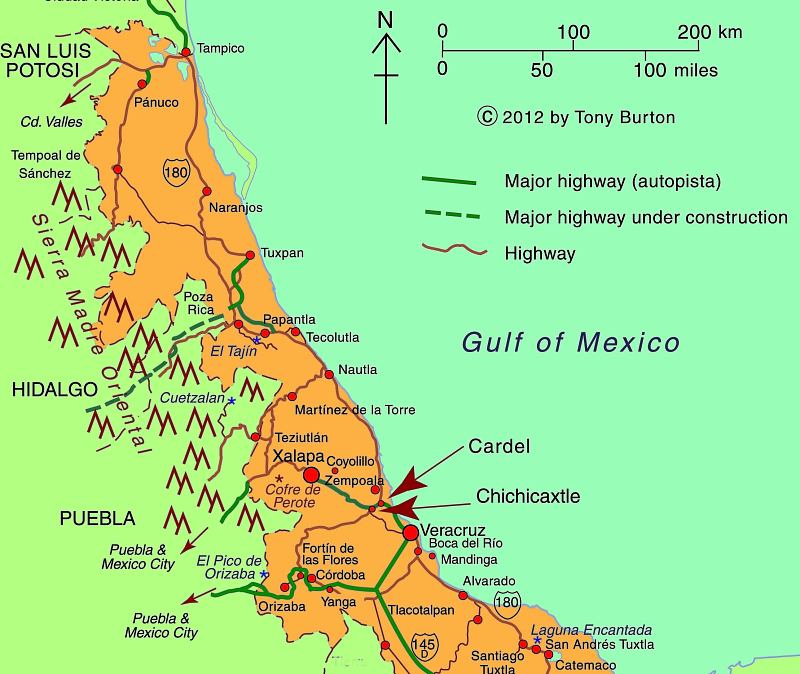
This massive migration has been studied since the early 1990s and scientists continue to tag birds today in order to update their estimates of bird populations and of the precise timing and routes involved. An official counts is held each year from 20 August to 20 November, organized by Pronatura Veracruz. The count is held in two locations: Cardel and Chichicaxtle (see map).

The counts have confirmed that Veracruz hosts the most concentrated raptor migration in the world.

One of the major long-term threats to this migration is habitat change in central Veracruz. Pronatura Veracruz sponsors an environmental education program known as “Rivers of Raptors” which tries to address this issue, helping local landowners appreciate the need for watershed protection and for an end to deforestation.

Pronatura’s work with raptors and the local communities is partially funded by ecotourism, and hawk-watching has become an important component of Mexico’s fledgling “ornithological tourism” market. Other key sites in Mexico for birding tourism include the tropical forests of the Yucatán Peninsula and Chiapas, and the San Blas wetlands in the western state of Nayarit.

Map of Central Veracruz

Map of Central Veracruz; all rights reserved. Click map to enlarge

In fact, Mexico is one of the world’s most important countries for birds, home to 1054 species of birds, 98 of them endemic, including 55 globally threatened species. Mexico has no fewer than 145 recognized “Important Bird Areas” (IBAs) of global significance, which between them cover 12% of the national land area (see summary map below).

Important Bird Areas in Mexico [Birdlife.org]

Important Bird Areas in Mexico [Birdlife.org]

Want to read more about the raptors?

Related posts:


Jun 072012
 

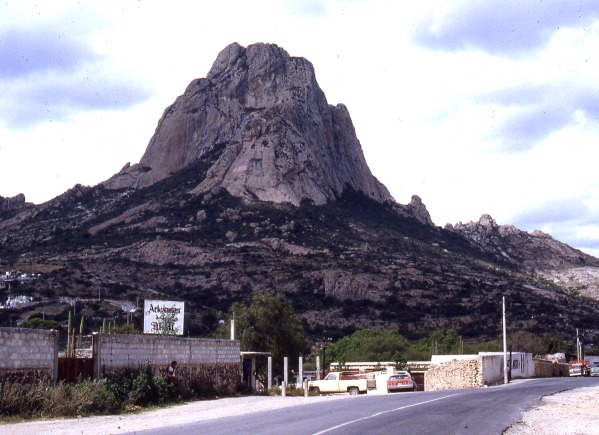
The Peña de Bernal, in the central state of Querétaro, is one of Mexico’s most distinctive geomorphosites. Geomorphosites are “landforms that have acquired a scientific, cultural/historical, aesthetic and/or social/economic value due to human perception or exploitation” (Panizza M., 2001). See Geotourism and geomorphosites in Mexico for a brief introduction to the topic.

The Peña de Bernal is a dramatic sight, which only gets more imposing the closer you get. How high is the Peña de Bernal? We are unable to give you a definitive answer (it depends where you start measuring from) but claims of 350 meters (1150 feet) sound about right, assuming we start from the town.

Peña de Bernal. Photo: Tony Burton; all rights reserved

The Peña de Bernal. Photo: Tony Burton; all rights reserved.

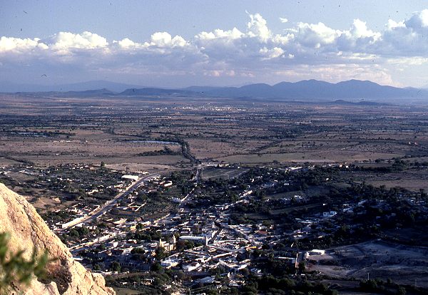
According to its Wikipedia entry, this is the “third tallest monolith in the world”, apparently only exceeded by the Rock of Gibralter and Sugarloaf Mountain in Rio de Janeiro. Others, including Melville King, have described it as the “third largest rock in the world”. These claims may (or may not) be exaggerated, but in reality it is definitely a very steep and tiring climb, even to reach the small chapel that has been built half-way up! The photo below is taken from this chapel, looking out over Bernal and the local farmland and vineyards.

View from the Peña Bernal, with the town of Bernal in the foreground.

View from the Peña de Bernal over the small town of Bernal. Photo: Tony Burton; all rights reserved.

How was the Peña de Bernal formed?

The most likely explanation is that this monolith represents the hardened magma (molten rock) from the central vent of a former volcano. This rock was much more resistant to erosion that the layers of ash and/or lava that formed the volcano’s flanks. Centuries of erosion removed the sides, leaving the resistant core of the volcano exposed as a volcanic neck. We will examine this idea in slightly more detail in a future post.

The town of Bernal

The town of San Sebastián Bernal is also well worth visiting. Having become a magnet for New Age types, it now boasts several decent restaurants, good stores and a range of hotels including high quality “boutique” hotels. Bernal was designated one of Mexico’s “Magic Towns” in 2005. To learn more about the town of Bernal and see some fine photos, we highly recommend Jane Ammeson’s article “The magic of Bernal, Querétaro: wine, opals and historic charm.

At the Spring Equinox (March 21), the town is invaded by visitors “dressed in long, white robes or gowns, and red neckerchiefs” who come seeking “wisdom, unity, energy and new beginnings”. (Loretta Scott Miller writing in El Ojo del Lago, July 1997).

How to get there:

From Mexico City, take the Querétaro highway (Hwy 57D) north-west to San Juan del Río. Then take Highway 120 past Tequisquiapan as far as the small cross-roads town of Ezequiel Montes. Turn left for about 11 kilometers, then right… and you’re there! Taking this route gives you glimpses of the Peña de Bernal from afar. Allow 2.0 to 2.5 hours for the drive.

Other geomorphosites worth visiting:

Mexico has literally thousands of geomorphosites. Among those described in previous posts are:


Nov 142011
 

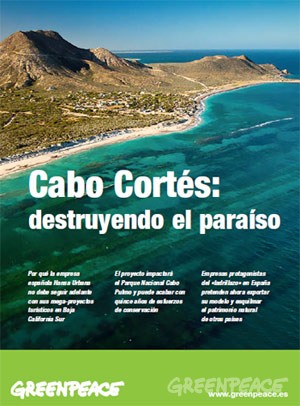
A few months back, we wrote of the conflicts surrounding the proposed tourist mega-development near Cabo Pulmo. The controversial plans for Cabo Cortés involve building on the virgin sand dunes, and will undoubtedly have adverse impacts on the small village of Cabo Pulmo and the ecologically-sensitive Cabo Pulmo National Marine Park and its coral reef.

Later, we followed up with an in-depth look at how the establishment of a Cabo Pulmo Marine Park had led to an astonishing recovery of the area’s biodiversity:

Cover of Greenpeace's position paper on Cabo Cortés

"Cabo Cortés: destroying paradise" (Greenpeace)

This story, which essentially pits mass tourism against ecotourism, continues to attract lots of media attention. The latest major article is Plans for resort in Mexico ignite concern about reef, published in The Washington Post. The article looks at the Spanish companies involved in the ownership and construction of the proposed resort and quotes the opinion of local people who hope that the economic crisis in Europe will put an end to their grandiose plans.

The Spanish firms involved are “ailing Spanish development conglomerate” Hansa Urbana, which bought the meg-development site in 2007, and a  savings bank called CAM (Caja de Ahorros del Mediterraneo), which lent Hansa millions of dollars.

Later, Hansa gave CAM the property in exchange for having its debt wiped clean. CAM has since been bailed out to the tune of $3.8 billion by the Bank of Spain, in which the Spanish government has a controlling interest. The Bank of Spain plans to auction CAM, but only after the upcoming Spanish elections.

As a result, and as the Washington Post article makes clear, “environmental activists are not even sure who controls the resort project anymore.”

Mexico’s federal Environment and Natural Resources Secretariat (Semarnat) originally gave Spanish firm Hansa Urbana the green light to begin construction, but now say that construction can only begin if the developers can prove that the reef will remain unharmed.

Mexican authorities are reported to be consulting with “expert marine biologists and U.N. officials”:

  • Misión conjunta de la UNESCO y Ramsar visitará Cabo Pulmo la próxima semana
  • La UNESCO visitará Cabo Pulmo

The government has set a deadline of January 2013 for the submission of a detailed report showing that construction will not cause any environmental damage to the Marine Park.

The deadline comes only a month after President  Calderon leaves office, which, as many locals realize, could be very unfortunate for the future welfare of the reef and local ecotourism activities.

Uxpanapa, an example of forced migration

 Excerpts from Geo-Mexico  Comments Off on Uxpanapa, an example of forced migration
Oct 312011
 

Almost all internal migration in Mexico in recent history has been voluntary. Tens of thousands of rural Mexicans have decided that life might be better somewhere else and have left their farms for the bright lights of the nearest large city. Their motivation is usually economic, but sometimes may be based on educational opportunities or access to health care.

However, not all internal migration has been voluntary. There have been some cases of forced migration, where the inhabitants of a village or area have been made to move away in order to make way for large-scale infrastructure projects such as reservoirs, tourism resorts and hotel complexes.

Since most good dam sites are in remote highland areas, with sparse population, forced migrations due to new dams are relatively rare in Mexico. One good example is when the building of the Cerro de Oro dam in the 1970s in northern Oaxaca, on a tributary of the River Papaloapan, flooded 360 square kilometers (140 square miles) and meant the forced relocation of more than 5000 Chinantec Indians. [Aguilera Reyes] The resettlement plan was one of the most forward-looking of its time. Villagers received compensation for their existing homes, trees and crops, and were offered a choice of possible resettlement sites.

They chose an area of rainforest-covered ridges and valleys near the headwaters of the Rivers Coatzacoalcos and Uxpanapa in the Isthmus of Tehuantepec. With government assistance they built a dozen new villages named, somewhat unimaginatively, Poblado Uno, Poblado Dos, etc. Extensive agricultural support was provided for several seasons, but the plan failed to live up to expectations, in part because its architect, the distinguished Mexican geographer Jorge Tamayo, was killed in a plane crash in 1978.

Many of the area’s young people have migrated (voluntarily) north. The remaining villagers grow ixtle, a fibrous cash crop produced from rainforest bromeliads that can be used for ropes and belts. They are also trying to introduce ecotourism to preserve what is left of their tropical jungle hideout, which has a rich biodiversity, including spider monkeys and jaguars. [Ginsberg]

References:

Aguilera Reyes, S. 2004 “Desarrollo, Población y Uso de los Recursos Naturales en el Valle de Uxpanapa.” Universidad Veracruzana Facultad de Sociología thesis. Xalapa,Veracruz. Marzo 2004.

Ginsberg, S. 2000 Report from Uxpanapa. Can bromeliads save Veracruz’s last rainforest? [6 September 2009]

Related posts:

This post is an edited excerpt from chapter 25 of Geo-Mexico: the geography and dynamics of modern Mexico. Buy your copy today!

Mexico adds three more Magic Towns to its list

 Mexico's geography in the Press  Comments Off on Mexico adds three more Magic Towns to its list
Oct 272011
 

Mexico’s Magic Town (Pueblo Mágico) program seeks to promote inland destinations that offer a complementary tourism based on historic and cultural attributes. The federal Tourism Secretariat has announced there will be 52 Magic Towns by 2012, when the promotional program is currently due to end. As many as 70 towns are reported to be seeking accreditation as Magic Towns. Some of these applicants are likely to join similar promotional groupings such as “Pueblos con Encanto” (Towns with Charm) and “Pueblos Señoriales” (Noble Towns).

Mexico currently has 44 Magic Towns:

The three latest towns to be added to the list are:

Magic Town #42: Mineral del Chico (Hidalgo)

Mineral del Chico is a small town (population 6700 in 2005; altitude 2351 m) at the entrance to the El Chico National Park in Hidalgo. The National Park, with its forests, mountains and waterfalls, is much better known than the town itself. This was the one of the earliest forested areas to be officially protected in Mexico. It was declared a Forest Reserve in 1898 and became a National Park in 1922.

Magic Town #43: Cadereyta (Querétaro)

The designation of Cadereyta as a Magic Town creates a great multi-day tourist trip including two other Magic Towns: Bernal and Jalpan de Serra. Cadereyta is known for its noisy and ebullient Holy Week (Semana Santa) processions, a tradition said to date back to the 18th century. The town has several interesting churches and two genuine colonial treasures. The gilded retable of the church of San Pedro and San Pablo has to be seen to be believed.

  • Tourism attractions of Cadereyta
  • Two colonial treasures of Cadereyta

Magic Town #44: Tula (Tamaulipas)

Close to the northern border, Tula, founded in 1617, is the oldest still-inhabited settlement in the state of Tamaulipas. The town has several colonial buildings but is best known for making elaborate leather jackets (cuera tamaulipeca), first designed in the 1950s.

These three latest newcomers all have their attractions, but, at least in my humble opinion, are not in the same league in terms of their historical and tourist interest as most previously-designated Magic Towns.

Related posts:

Oct 062011
 

The small town of Tequila, the center of production of Mexico’s national drink, lies in the shadow of an imposing 2700-meter (8860-ft) volcano. Most visitors to the town visit the National Tequila Museum, take a distillery tour, and then sample one or two of the many world-famous brands of tequila made in the area.

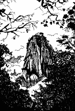
The spine of Tequila Volcano

The spine of Tequila Volcano. Drawing by Mark Eager (Western Mexico, A Traveler’s Treasury); all rights reserved.

Tequila Volcano, which overlooks the rolling fields of blue agaves required to make the liquor, is the home of one of Mexico’s most distinctive geomorphosites. From the rim of its crater, the most arresting thing about the view is not the green, tree-covered crater itself but the giant monolith with almost vertical sides rising perpendicularly from the middle of the crater floor.

This well-preserved central spine, known locally as la tetilla (“the nipple”) is quite unusual. It represents the hardened lava which cooled in the central vent of the volcano and which, solid and unyielding, was later pushed upwards by tremendous subterranean pressure.

Few such good examples exist anywhere in the world. The example most often quoted in geography texts is the spine that was pushed up by Mont Pelée on the island of Martinique in the West Indies in October 1902, immediately prior to that volcano’s disastrous eruption which cost 32,000 lives.

How to get there

A cobblestone road begins near the railway station in the town of Tequila and winds up Tequila Volcano towards the short-wave communications tower on its rim. It is about 20 kilometers from the town to the rim. The hike or drive up to the rim affords glorious views over the surrounding countryside. As you gain altitude, so the vegetation changes, becoming luxuriant pine-oak forest well before you reach the rim. Looking across the crater, on a day when clouds slowly drift across and partially obscure the view, is like watching a silent movie of ancient Chinese landscape drawings.

Want to read more?

For a fuller description of a visit to Tequila Volcano and a climb up the volcanic spine, see John and Susy Pint’s Outdoors in Western Mexico (2nd edition 2011).

For a description of Tequila Volcano and the varied villages and sights in its vicinity, see chapters 9 and 10 of my “Western Mexico: A Traveler’s Treasury” (Sombrero Books, 2013), also available in a Kindle edition.

Mexico’s geomorphosites: The Piedras Bola (Stone Balls) of the Sierra de Ameca, Jalisco

 Other  Comments Off on Mexico’s geomorphosites: The Piedras Bola (Stone Balls) of the Sierra de Ameca, Jalisco
Sep 272011
 

The Sierra de Ameca is a range of hills a short distance west of Guadalajara. The area was important in colonial times for gold and silver mining. One of the mines is called Piedra Bola (Stone Ball). The landscape immediately around this mine is so distinctive and unusual that it featured on the cover of the August 1969 edition of National Geographic.

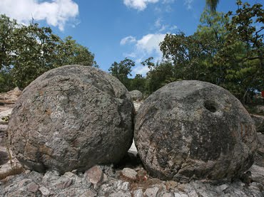
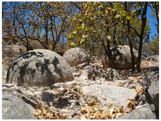
In the middle of the forest surrounding the Piedra Bola mine are about a hundred strange stone balls. They are almost perfectly spherical and range in diameter from about sixty centimeters to more than ten meters. These symmetrical boulders are unusually large. Nothing quite like them exists elsewhere in Mexico and few similar examples are known anywhere in the world.

Piedras Bola

Piedras Bola

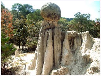
Some are buried, others partly or fully exposed. In some places, erosion of the surrounding rocks has left a sphere perched precariously atop narrow columns of softer rock, seemingly ready to topple in the next strong wind. These “hoodoos” or earth pillars have been formed as a result of water erosion and they may survive for centuries until the processes of sub-aerial weathering and erosion finally cause them to fall.

Piedra Bola atop an earth pillar

Piedra Bola atop an earth pillar

How were the Piedras Bola formed?

This summary of the most likely explanation of the origin of the stone spheres is based on that offered by Dr. Robert Smith of the U.S. Geological Survey in the original National Geographic article.

During the Tertiary geological era, 10-12 million years ago, a local volcano erupted, causing a deluge of glassy fragments of molten lava and ash, together with large quantities of volcanic gas trapped in the mixture. The mixture was very hot, probably between 550 and 800̊C. The deluge of material partially filled an existing valley, burying the former surface.

As the mixture cooled down, the existing glassy fragments formed nuclei around which much of the remainder of the material crystallized. Spherical balls began to form, their size depending on how long the crystallization process continued uninterrupted. The longer the time, the bigger the ball…. The most perfect balls were formed near the previous ground level, inside the hot mass of ashes, where the cooling would have occurred more evenly than in the bulk of the matrix material. The crystallized material is a kind of rhyolite which has an identical chemical composition to the fragments of glassy obsidian also found in the area.

The remainder of the ashes cooled down and became a consolidated accumulation of ashes and glassy fragments or tuff, without clearly defined spheres. This tuff is weaker, and has a lower density than the stone balls within it. During succeeding millenia, the combined processes of physical and chemical weathering weakened the surrounding tuff, and water (rain and rivulets) then eroded away this loose material, exposing some of the rhyolitic boulders completely and others partially.  As these processes continue, so more of the boulders will be exhumed from beneath their cover of tuff, and be revealed to us.

Protected?

The Jalisco State government has developed a small park around the Piedras Bola, including decent trails, some signposts and an amphitheater. There are even (reportedly) two ziplines, though I haven’t yet had the dubious pleasure of seeing them for myself. Increasing the number of visitors to  geomorphosites is not a bad idea, but some basic education and protection is needed if these and other geomorphological sites are going to be preserved intact for future generations. In the case of the Piedras Bola, graffiti now mar many of the exposed stone spheres and some of the spheres have been dynamited, apparently in the mistaken belief that the center of the sphere contained gold.

picture of piedras bolaHow to get there:

The entrance road to the Piedras Bola (formerly only a hiking trail) begins from km. 13 of the paved road that crosses the mountains from Ahualulco to Ameca. For anyone who does not have time for the hike, but still wants to see what these extraordinary stone spheres look like, the locals have thoughtfully rolled one down the mountain and onto Ahualulco’s main plaza.

Want to read more?

For more images and details, see John Pint’s article, Las Piedras Bola: the great stone balls of Ahualulco, on MexConnect, together with his outstanding gallery of photos.

Sep 082011
 

Geotourism is geography tourism (as opposed to tourism geography!). It applies to any recreational (tourism) activity where one of the primary objectives is to visit some phenomenon of geographic importance. This could be a coral reef, mangrove swamp, volcano, mountain peak, cave or canyon, but it could just as easily be a sinkhole, waterfall, new town or sugar mill. Ideally, geotourism should be sustainable, ecologically-aware and culturally-sensitive.

Geotourism often involves visiting landforms that hold special value: geomorphosites. Mexico has an amazing diversity of geomorphosites, quite possibly the richest collection of any country in the world.

What exactly are geomorphosites?

Geomorphosites were first defined in 1993 by Mario Panniza. Essentially, they are landforms that have acquired, over time, a certain value. Once noticed and made accessible to people, the landforms acquire scientific, cultural, historical, aesthetic, and socio-economic value. [1]

Panniza subsequently defined geomorphosites as,”landforms that have acquired a scientific, cultural/historical, aesthetic and/or social/economic value due to human perception or exploitation.” [2]

Reynard and Panniza state that geomorphosites can vary in scale from a single geomorphological object (eg a sink hole) to a wider landscape (eg a mountain range) and that geomorphosites “may be modified, damaged, and even destroyed by the impacts of human activities.” [3]

The marine arch at Cabo San Lucas, an example of a geomorphosite

The marine arch at Cabo San Lucas, an example of a geomorphosite

The dominant additional value may be economic, ecological, aesthetic or cultural, and this provides a starting point for assessing whether or not a particular landform is a geomorphosite or not.

The science study (see first comment below!) of geomorphosites is still in its infancy. Several competing classifications have been proposed, and no definitive consensus has yet been reached on the best way to quantify the value of a particular example.

One set of criteria for assessing geomorphosites includes:

A. Economic value:

  • accessibility,
  • number of visitors,
  • inclusion in promotional literature

B. Scientific/ecological value:

  • palaeogeographical interest,
  • singularity,
  • integrity (state of conservation)
  • ecological interest

C. Aesthetic value:

  • the number and spacing of belvedere points (high points from which a view is possible over the surrounding landscape)
  • shape
  • altitude
  • color

D. Cultural value:

  • cultural legacy (writing, art etc),
  • historical and archaeological significance,
  • religious relevance,
  • artistic and cultural events

Mexico has literally thousands of geomorphosites. We have already described some of them, including:

and we plan to highlight many more in future posts, including:

  • Piedras Bola (Stone Balls) in Jalisco
  • Peña de Bernal, a monolith in Querétaro
  • Sumidero Canyon in Chiapas
  • the iconic marine-eroded arch at Cabo San Lucas (see photo)

The scientific study of geomorphosites should enable researchers to suggest ways to approach their management. Unlimited access to some geomorphosites may generate a healthy flow of admission fees but could also easily increase erosion and hasten the destruction of the very thing that the tourists are paying to see.

On your next trip to Mexico, make sure to visit one or more of the country’s super-numerous geomorphosites!

References:

[1] Comanescu and Nedelea, Area (2010) 42:4, 406-416.

[2] Panizza M. (2001) Geomorphosites : concepts, methods and example of geomorphological survey. Chinese Science Bulletin, 46: 4-6

[3] Reynard, E and Panizza, M. (2005 ) Geomorphosites: definition, assessment and mapping, Géomorphologie : relief, processus, environnement , 3/2005

The extraordinary ecological recovery of Mexico’s Cabo Pulmo Marine Park

 Updates to Geo-Mexico  Comments Off on The extraordinary ecological recovery of Mexico’s Cabo Pulmo Marine Park
Aug 152011
 

In an earlier post—Can Mexico’s Environmental Agency protect Mexico’s coastline? we took a critical look at proposals for a tourism mega-development near Cabo Pulmo on the eastern side of the Baja California Peninsula. Cabo Pulmo (see map), a village of about 120 people, is about an hour north of San José del Cabo, and on the edge of the Cabo Pulmo National Marine Park (CPNP).

Baja California Sur MapJacques Cousteau, the famous ocean explorer, once described the Sea of Cortés as being the “aquarium of the world.” The protected area at Cabo Pulmo, ideal for diving, kayaking and snorkeling, covers 71 sq. km of ocean with its highly complex marine ecosystem.

Cabo Pulmo is on the Tropic of Cancer, about as far north as coral usually grows. The water temperatures vary though the year from about 20 to 30 degrees C (68 to 86 degrees F).

The seven fingers of coral off Cabo Pulmo comprise the most northerly living reef in the eastern Pacific. The 25,000-year-old reef is the refuge for more than 220 kinds of fish, including numerous colorful tropical species. Divers and snorkelers regularly report seeing cabrila, grouper, jacks, dorado, wahoo, sergeant majors, angelfish, putterfish and grunts, some of them in large schools.

On my last visit to Cabo Pulmo in 2008, local fishermen and tourist guides regaled me with positive comments about the success of the National Marine Park, and the area’s recovery since the area was first protected in 1995. Ever since, I’ve wondered how much their positive take was due to wishful thinking, and how much was due to a genuine recovery in local ecosystems. My doubts have been answered by the publication of Large Recovery of Fish Biomass in a No-Take Marine Reserve in the Public Library of Science (PLoS) ONE journal. The article’s authors present compelling evidence, based on fieldwork, that the area has undergone a remarkable recovery.

Recovery of Cabo Pulmo Marine Park

Recovery of fish in the Cabo Pulmo National Marine Park (CPNP). Credit: Aburto-Oropeza et al (2011)

The graph above shows the changes in biomass for three distinct zones of the Sea of Cortés. The open access areas allow commercial fishing. The “core zones” are the central areas of other Marine Parks in the area, including those near Loreto, north of Cabo Pulmo. The CPNP is the Cabo Pulmo National Marine Park, where no fishing is allowed. Clearly, since the CPNP was established, the number and weight of fish inside the park boundaries really have increased rapidly.The total amount (biomass) of fish increased by a staggering 460% over 10 years.

The major reason for the success of the CPNP has been the strength of local residents in undertaking conservation initiatives, and their cooperative monitoring and enforcement of park regulations, sharing surveillance, fauna protection and ocean cleanliness efforts.

The Cabo Pulmo National Marine Park is perhaps the world’s best example of how local initiatives can lead to genuine (and hopefully permanent) environmental protection. The researchers describe it as “the most robust marine park in the world” and say that “The most striking result of the paper… is that fish communities at a depleted site can recover up to a level comparable to remote, pristine sites that have never been fished by humans.”

Here’s hoping that the residents of other parts of Mexico’s coastline threatened by fishing or tourism developments take similar actions and manage to achieve equally positive results for their areas.

Citation:

Aburto-Oropeza O, Erisman B, Galland GR, Mascareñas-Osorio I, Sala E, et al. (2011) Large Recovery of Fish Biomass in a No-Take Marine Reserve. Public Library of Science (PLoS) ONE 6(8): e23601. doi:10.1371/journal.pone.0023601

Further reading:

For an exceptionally informative series of papers (in Spanish) on all aspects of tourism and sustainability in Cabo Pulmo, see Tourism and sustainability in Cabo Pulmo, published in 2008 (large pdf file).

Another valuable resource (also in Spanish) is Greenpeace Spain’s position paper entitled Cabo Cortés, destruyendo el paraíso (“Cabo Cortés: destroying paradise”) (pdf file)

How ecological is ecotourism in Mexico?

 Excerpts from Geo-Mexico  Comments Off on How ecological is ecotourism in Mexico?
Jun 162011
 

Ecotourism is often touted as one solution to many of the potential woes associated with conventional resort tourism. It should come as no surprise to find that Mexico has embraced ecotourism: Mexico’s biodiversity is phenomenal. It is one of the five most important countries in the world in terms of biodiversity:

To be ecologically successful, ecotourism probably has to be small-scale. Constructing the infrastructure necessary for large-scale coastal ecotourism projects often involves the destruction of highly productive (in ecological terms) wetlands, including tropical mangroves. These ecosystems play a vital role in helping preserve biodiversity and their destruction has serious long-term economic implications for fishing, port and marina access, coastline preservation and beach-based tourism.

Marine biodiversity

Mangroves (pictured on the right of the image) are especially vulnerable, with an undeserved reputation for being impenetrable thickets harboring noxious insects and reptiles. Mangroves sequester carbon and help reduce the organic content of water. Their roots bind unstable coasts, preventing erosion and acting as a natural barrier against hurricanes. They are important breeding, shelter and feeding places for fish, crustaceans and birds as well as being a source of charcoal, firewood, wood and roofing materials. They offer economic opportunities of fishing for shrimp, mollusk, fish and crustaceans.

In the year 2000, the total area of mangroves along Mexican coasts was estimated at 880,000 hectares (2.2 million acres), approximately two-thirds on the Atlantic and Caribbean coasts, and one-third on the Pacific. The annual loss of mangroves is estimated to be between 2.5% and 5% of this area. Even with the lower rate of loss, by 2025 mangroves will occupy only half of their 2000 area. In 2007 Mexico enacted federal legislation to protect existing mangroves.

The unique habitats of coral reefs are also at risk. Mexico has important zones of coral from the Baja California Peninsula and Sea of Cortés in the north to Cozumel Island and Chinchorro Bank in the south. The latter area is the northernmost extension of the Meso-American Barrier Reef system which is the world’s second largest reef system after Australia’s Barrier Reef. Marine pollution, overfishing and tourism have all hastened the decline of coral reefs,though many areas are now protected.

Even animal migrations are considered at risk. Some studies have shown that the number of tourists viewing the whale migrations off the coast of Baja California, for instance, is already having an adverse effect on the whales’ breeding habits.

– – –

This is an excerpt from chapter 19 of Geo-Mexico: the geography and dynamics of modern Mexico. Buy your copy today, and learn more about Mexico’s fascinating geography. The more knowledge you acquire, the more pleasure you will derive from your next trip to Mexico!

Why Las Tuxtlas Biosphere Reserve is well worth a visit

 Other  Comments Off on Why Las Tuxtlas Biosphere Reserve is well worth a visit
Jun 132011
 

In a recent post, we looked at an Enchanted Lake in southern Mexico, in the Sierra de las Tuxtlas, near Catemaco in the Gulf Coast state of Veracruz. In this post we take a look at the surrounding Las Tuxtlas Biosphere Reserve.

Tuxtlas biosphere reserve

Scenically, the entire Tuxtlas region is one of the most fabulously beautiful in all of Mexico. High temperatures combined with lots of rainfall result in luxuriant vegetation and boundless wildlife. Average monthly temperatures range from a pleasant 21 degrees C (70 degrees F) in January to a high of 28 degrees C (82 degrees F) in May, just before the rainy season kicks in. During the rainy season, from June to October, some 2000 mm (79 inches) of rain falls, often in late afternoon tropical deluges.

The jungle masking the lower slopes of the San Martín volcano gradually merges into tropical cloud forest at higher altitudes. Competing with the Silk Cotton (Kapok) and Ficus trees for light and sustenance are ground-hugging ferns. Overhead, the tangle of tree branches provides support for thousands of non-parasitic bromeliads (“air” plants) and orchids. More than 1300 species of flowering plants have been identified in this classic area for Neotropical ecology.

Bird-watchers are likely to spot the spectacular Keel-billed Toucan, or hear a Tody Motmot. Smaller birds include several species of hummingbird; look for the endemic Long-tailed Sabrewing. About half of all the bird species recorded in Mexico have been seen here, but birds are not the only wild animals inhabiting the jungle. Ocelots and tapirs are regularly seen and you may be lucky enough to see spider monkeys playing overhead in the canopy.

Clearance of the land for grazing and cultivation of the slopes to grow tobacco, bananas and sugar cane have reduced the original jungle to a relatively small number of isolated fragments. Fortuitously, this provides more varied habitats than the original vegetation, helping to enrich the area’s wildlife, further enhancing the region’s reputation as an ornithological and botanical paradise.

Fortunately an extensive area of this region was declared a Biosphere Reserve in 1998, ensuring that conservation programs now go hand-in-hand with human activities. The total area forming the Reserva de la Biósfera “Los Tuxtlas” is 155,122 hectares (380,000 acres).

Chapter 5 of Geo-Mexico: the geography and dynamics of modern Mexico focuses on Mexico’s ecosystems and biodiversity.  Chapter 30 analyzes environmental issues and trends including current environmental threats and efforts to protect the environment.  Buy your copy today to have a handy reference guide to all major aspects of Mexico’s geography!

The nondescript city of Zitácuaro, Michoacán, is the unhappy star of a New Yorker article

 Mexico's geography in the Press  Comments Off on The nondescript city of Zitácuaro, Michoacán, is the unhappy star of a New Yorker article
Nov 132010
 

The city of Zitácuaro in the state of Michoacán had played an important part in Mexican history (hence its full official name of Heróica Zitácuaro) but was largely ignored by tourists until the early 1980s. Things changed, and tourists started coming, when the locations of the Monarch butterfly overwintering sites were first published. The Monarchs had been undertaking their amazing annual migration from Canada and the USA to the rugged mountains close to Zitácuaro for hundreds, possibly thousands of years, but it was only in the early 1980s when articles in newspapers and science journals first provided locational details.

The Monarch butterflies have since become one of the major ecotourist attractions in this part of Mexico. On a single day in February, more than 5,000 tourists enter the main Monarch reserve El Rosario, accessed from either Angangueo or Ocampo, about 40 minutes driving time from Zitácuaro. Hotels in this area have done well out of the annual November-March “butterfly season”. Indeed, the demand led to the construction of several new hotels in the area, some of them more than large enough to handle tourist groups arriving by the coachload.

In 1980, I began leading regular fieldtrips to Zitácuaro and its surrounds, the major attractions being wonderful scenery and an interesting mix of settlement types, covering everything from 4-hut hamlets to the medium-sized city of Zitácuaro, which had a population at the time of about 100,000.  Over the years, I’ve watched Zitácuaro grow into a much larger city. When the bypass was first built, and federal Highway 15 rerouted around the town instead of along Avenida Revolución, it was ignored by most motorists, who preferred to drive through the city, often stopping for gas or food before continuing their journey. Within a few years, services had begun to spring up, as if by magic, alongside the bypass. Today, the city has spread well beyond the confines of the bypass.

In recent years, violence related to drug trafficking has reached the city. This is perhaps somewhat surprising, given its location far from the USA border, and far from the traditional territories of the main drug cartels. But, as we saw in an earlier post (The geography of drug trafficking in Mexico),  Zitácuaro is very close to the edge of the “territories in dispute” immediately to the west of Mexico City. Violence in these areas is growing as rival groups seek to control the lucrative drug trade. The La Familia crime group is responsible for most drug-related violence in Michoacán.

An article in the New Yorker earlier this year described in detail how La Familia has increasingly threatened the rule of law in  Zitácuaro. The article serves as a good introduction to how an ordinary Mexican city – in this case Zitácuaro – can be dramatically changed by a committed and ruthless criminal group.

An overview of the geography of drug trafficking in Mexico forms part of chapter 20 of Geo-Mexico: the geography and dynamics of modern Mexico. Buy your copy today!

Related post about drug cartels in Mexico:

The thorny issues of plant and animal trafficking and biopiracy in Mexico

 Excerpts from Geo-Mexico  Comments Off on The thorny issues of plant and animal trafficking and biopiracy in Mexico
Oct 282010
 

In several previous posts we examined the megadiversity of Mexico’s ecosystems which include more than 10% of all the world’s living species.

Mexico’s biodiversity is under pressure from several quarters.

Plant and animal trafficking

Selling wildlife by the roadside in Chihuahua state

Roadside entrepreneurs sell wildlife in Chihuahua state. Photo: Tony Burton; all rights reserved.

Plant and animal trafficking is the country’s third largest criminal activity after illegal drugs and arms smuggling. Favored items include cacti, live birds (some species sell for upwards of $100,000), spider monkeys, sea turtles, snakes and jaguars. Mexico is one of 175 nations that have signed the Convention on International Trade in Endangered Species (CITES) but this has had no discernible effect on the trafficking of flora and fauna.

Biopiracy

Mexico’s megadiversity presents both opportunities, for activities such as ecotourism, as well as challenges such as preventing biopiracy. In its simplest form, biopiracy occurs whenever a bioprospector takes biological material from a place and then acquires a patent or intellectual property rights on it, or one of its constituents, elsewhere. The best documented example of biopiracy in Mexico occurred in 1999 when a US patent was granted to Colorado-based company Pod-ners for the exclusive right to market Enola beans bred from Mexican yellow beans bought only five years previously. Mexico’s bean export business collapsed overnight as shippers were accused of patent infringement. Yellow bean production in Sinaloa fell by 62% in three years.

Mexican growers subsequently proved that the yellow beans they had been breeding for decades are genetically identical to Enola beans but the damage had been done. Subsequently, the patent was challenged by the International Center for Tropical Agriculture. In 2008 the US patent office finally reversed its decision and rejected any patent claims on yellow beans. While this case of biopiracy was thwarted, acts of biopiracy, by their very nature, are usually clandestine and there are certain to be other instances in the future.

This is an excerpt from chapter 30 of Geo-Mexico: the geography and dynamics of modern Mexico. Buy your copy today, and learn more about Mexico’s fascinating geography. The more knowledge you acquire, the more pleasure you will derive from your next trip to Mexico!

The geography of Mexico’s caves

 Mexico's geography in the Press  Comments Off on The geography of Mexico’s caves
Oct 022010
 

For a fascinating overview of caves and caving in Mexico, see John Pint’s great article and image gallery (link below) on MexConnect. Pint is an accomplished caver and author who has explored caves on several continents. His writing is clear and authoritative, much of it based on his own first-hand experiences and investigations.

Caves have played an important part in Mexico’s history. The Maya on Mexico’s Yucatán Peninsula, which is largely limestone, and now known to be riddled by amazing interconnected sinkholes and subterranean tunnels, viewed caves as entrances to an underworld. They revered some caves in particular, adorning them with lavish offerings.

Cacahuamilpa cave

The sinkholes of the Yucatán Peninsula are beautiful, but are not all that deep. In the state of Tamaulipas, El Zacatón is a sinkhole that is considered the deepest water-filled sinkhole in the world.

In the early days of tourism in Mexico, the Cacahuamilpa Caverns near Taxco (Guerrero) were a popular place to visit. The English traveler Mrs. Alec Tweedie recalls in Mexico as I saw it how she was deep underground in these caves when a telegram arrived bearing the sad news that Queen Victoria had passed away. (If only postal and telegraph services were that efficient today!)

In recent years, scientists have begun to unravel the mysteries of how strange forms of life can thrive deep underground, even in environments that are noxious to humans. The sulfur-loving organisms of the Cueva de la Villa Luz in the state of Tabasco are a much-studied example.

Pint also discusses lava caves, of which Mexico has some fine examples. One of the most visited lava caves in the world must be that which plays home to the La Gruta restaurant, close to the famous archaeological site of Teotihuacan.

And, finally, for one of the most spectacular caves imaginable, how about the Naica crystal caves?

Visit John Pint’s website for a selection of his writing, with many original articles, illustrated with great photographs, about individual caves in Mexico.

Sadly, we did not have room in Geo-Mexico: the geography and dynamics of modern Mexico to delve beneath the surface into the wonders of Mexico’s caves.  Mexico’s landforms are discussed in chapter 3, which may be expanded in future editions, depending on the feedback from readers like you. If you have not yet read a copy, please ask your local library for a copy, or better yet, please consider purchaing your own copy via this website or amazon.com

Feedback from readers about any aspect of Geo-Mexico: the geography and dynamics of modern Mexico is welcomed.

Sep 152010
 

The remote Copper Canyon region in northern Mexico is the home of 50,000 Tarahumara Indians who have preserved much of their distinctive culture (language, dress, customs, beliefs) into this century, partly because of their extreme remoteness. Many live untouched by the trappings of modern civilization, moving between caves just below the canyon rim and warmer, winter shelters at lower altitude near the Urique River.

Modern hotels are encroaching on the Copper Canyon

Modern hotels are encroaching on the Copper Canyon, and changing the views in this wilderness region. Photo: Tony Burton; all rights reserved.

Their radically different lifestyle and extreme isolation beg many questions. Their ancestral homelands are already being invaded by marijuana-growers and trampled on by outside developers who have very different notions of property rights and very different customs.

Questions to think about:

  • Are the Tarahumara Indians really in any position to make informed decisions about their future?
  • Should we leave them entirely alone and let them decide entirely for themselves?
  • Should we offer education about what we would consider the benefits of the modern world?
  • Should we improve their access to health services and hospitals?
  • Should we encourage them to acquire computers and internet access?
  • Might these progressive elements destroy their existing lifestyle, break down their social and political structures and ultimately wipe them out?
  • What do YOU think? Now, imagine you were a Tarahumara Indian – would you think the same?
  • Who should decide the future of this region?

Previous Geo-Mexico posts related to the Copper Canyon:

Chapter 10 of Geo-Mexico: the geography and dynamics of modern Mexico is devoted to Mexico’s indigenous peoples, including the Tarahumara Indians. If you have enjoyed this post, please suggest to your local library that they purchase a copy to enhance their collection.