Dec 092017
 

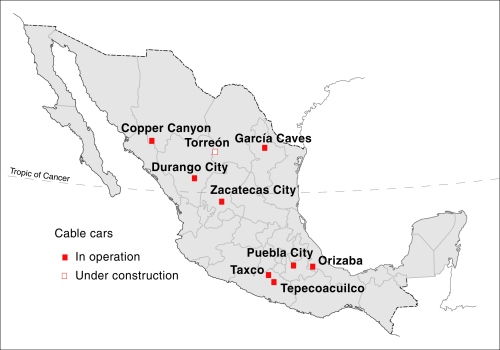
There are now at least nine cable cars (teleféricos) for tourism operating in Mexico :

  • Durango City, Durango
  • Copper Canyon (Barrancas del Cobre), Chihuahua
  • García Caves (Grutas de García), Nuevo León
  • Zacatecas City, Zacatecas
  • Hotel Montetaxco, Taxco, Guerrero
  • Hotel Vida en el Lago, Tepecoacuilco, Guerrero
  • Orizaba, Veracruz
  • Puebla City, Puebla
  • Torreón, Coahuila

All these cable cars are primarily designed for sightseeing and tourism, rather than as a means of regular transport for local inhabitants. In addition, there is at least one urban cable car in the Mexico City Metropolitan Area designed for mass transit:

Mexico-Cable-Cars

Durango City

The Durango teleférico, inaugurated in 2010, is 750 meters long. It links Cerro del Calvario in the historic center of the city with the viewpoint of Cerro de Los Remedios. It cost about $70 million to build and its two gondola cars can carry up to 5000 people a day. Parts of the ride are some 80 meters above the city. The system was built by a Swiss firm and is one of only a handful of cable cars that start from a historic city center anywhere in the world. (The Zacatecas City cable car is another).

Copper Canyon (Barrancas del Cobre) in the state of Chihuahua

The Copper Canyon teleférico starts alongside Divisadero railway station in Mexico’s famous Copper Canyon region, and runs 2.8 km across a section of canyon, up to 400 meters above the ground level. Inaugurated in 2010, it is the longest cable car in Mexico, cost $25 million and can carry 500 passengers an hour, using two cabins (one traveling in each direction), each able to hold 60 people. It is a 10-minute ride each way to the Mesa de Bacajipare, a viewpoint which offers a magnificent view of several canyons.

García Caves (Grutas de García) in Nuevo León

The Garcia Caves are located in the Cumbres de Monterrey National Park, 9 km from the small town of García, and about 30 km from the city of Monterrey. The caves are deep inside the imposing Cerro del Fraile, a mountain whose summit rises to an elevation of 1080 meters above sea level, more than 700 meters above the main access road. The entrance to the caves is usually accessed via a short ride on the 625-meter teleférico, which was built to replace a funicular railway.
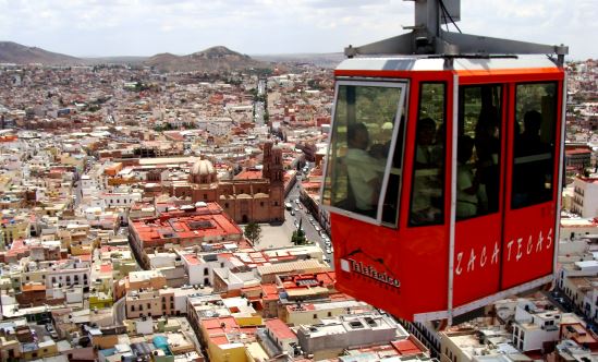
zacatecas-teleferico

Zacatecas City

The Zacatecas teleférico, opened in 1979, is 650 meters long and links the Cerro del Grillo, near the entrance to the El Eden mine on the edge of the city’s historic center, with the Cerro de la Bufa. It carries 300,000 people a year high over the city, affording splendid views of church domes, homes, narrow streets and plazas during a trip that lasts about ten minutes. On top of Cerro de la Bufa is an equestrian statue of General Doroteo Arango (aka “Pancho” Villa), commemorating 23 June 1914, when he and his troops successfully captured the city after a nine-hour battle.

La Bufa is also the setting for a curious children’s New Year legend involving a giant cave housing a great palace with silver floors, gold walls, and lights of precious stones. This palace is inhabited by thousands of gnomes, whose job is to look after the future “New Years”. Each December the gnomes choose which “New Year” will be given to the world outside… (For the full story, see chapter 21 of my Western Mexico, A Traveler’s Treasury)

Hotel Montetaxco, in Taxco, Guerrero

This hotel teleférico is a convenient link between the hotel, set high above the city, and the downtown area of this important tourist destination, best known for its silver workshops.

Hotel Vida en el Lago, in Tepecoacuilco, Guerrero

A second hotel in Guerrero also has its own teleférico, running from the hotel to a viewpoint atop the Cerro del Titicuilchi.

Orizaba, Veracruz

Cable car in Orizaba, Mexico

A 950-meter-long cable car, using 6-person cabins (see image), began operations in the city of Orizaba in Veracruz in December 2013. The cable car goes from Pichucalco Park, next to the City Hall in downtown Orizaba, to the summit of Cerro del Borrego. which overlooks the city. The 8-minute ride affords outstanding views over the city center.

Puebla City

Initial construction of the teleférico in the city of Puebla, in central Mexico, was halted in 2013, amidst considerable controversy about its route and the demolition of a protected, historic building (the Casona de Torno) in this UNESCO World Heritage city. The original route was 2 kilometers long and linked the historic center of Puebla with a nearby hill, home to the forts of Loreto and Guadalupe. In 1862, these forts were the site of the famous Battle of Puebla, at which Mexican forces proved victorious over the French, a victory celebrated each year on 5 May (Cinco de Mayo).

When it proved impossible to inaugurate this cable car in time for Mexico’s 2013 Tourist Tianguis (the largest tourism trade fair in Latin America), authorities boarded up the partially-completed structures (3 metal towers and 2 concrete bases) to completely hide them from public view. Construction resumed in 2014, but only of a 688-meter-long stretch which cost $11 million to build. This section, which includes a tower in Centro Expositor, the city’s main exhibition center, was officially opened in January 2016. The 5-minute ride costs about $30 pesos ($1.60) each way.

Torreón, Coahuila (opened December 2017)

Italian firm Leitner Ropeways constructedTorreón’s cable car. (Leitner built Mexico’s first cable car for regular urban transit in Ecatepec in the State of Mexico). The Torreón cable car runs 1400 meters between Paseo Morelos in the downtown area and the Cerro de las Noas, site of the large sculpture El Cristo de las Noas, reputedly the largest statue of Christ in North America.

The system will initially have nine 8-pasenger cabins giving a capacity of about 380 passengers an hour each way. The cable car cost between $9 million and $10 million. It was originally due to enter service in December 2016 but finally opened in December 2017. Users pay about 3 dollars for a round trip (about 5 minutes each way). City officials hope its completion will provide a welcome boost to Torreón’s fledgling tourism sector.

[Note: This is an updated version of a post first published in 2014]

Related posts:

Nov 292015
 

Line 12 of Mexico City’s Metro (subway) system was originally opened in October 2012. The new line, also known as the Golden Line, extended the city’s metro system into several lower income areas in the south-eastern part of the city, including Tlahuac, Milpa Alta, Xochimilco and Iztapalapa.

However, in March 2014, the elevated (above ground) 14-kilometer-long (9 mi) southern section of this line between Tlahuac and Atlalilco stations was closed for emergency repairs. A replacement bus system was established between those stations. According to a report in the Mexico City daily Reforma (citing a study by ILF Consulting Engineers), the design of tracks in that section had resulted in damage to the wheels of several metro trains. It also resulted in the failure of an electric cable and caused cracks and fractures in the track supports. Authorities have blamed some former city officials, together with the line’s builders, a consortium comprised of France’s Alstom and the Mexican companies ICA and Carso.

Metro Line 12 was finally fully reopened 20 months later, on 29 November, 2015. Line 12 is the longest line in the city’s metro network,extending 25 km (15.5 miles), with 20 stations, including four transfer points. In terms of network connectivity, it added an important east-west link connecting four lines that serve the southern section of the metro area. Line 12 runs from Mixcoac (Line 7) to Tlahuac in the southeast of Mexico City, intersecting with line 3 at Zapata, line 2 at Ermita and line 8 at Atlalilco.

Mexico-City-Metro-MapOfficials estimate that the line, which has both underground and overground sections, eliminates 860 buses from the city’s congested streets, reducing carbon dioxide emissions by 22,000 metric tons a year. It cost about $1.8 billion to construct.

Mexico City metroBetween 400,000 and 450,000 passengers are now expected to use Line 12 daily. It is expected to cut the average daily commuting time from those parts of the city it serves by more than an hour a day, from 150 minutes to 78 minutes. The line is only accessible by using the new metropolitan smart transport card “Tarjeta DF”.

The complete network of 12 lines comprising Mexico City’s metro system, used by more than 5 million passengers a day, now has 195 stations and a total length of about 227 km (141 miles).

Will the line eventually be extended?

In January 2013, officials of Mexico City’s Metro system (Sistema de Transporte Colectivo, STC)  announced that they were considering extending Line 12 westwards into the Álvaro Obregón district of the city. This is still being talked about. STC’s Managing Director Joel Ortega Cuevas also said that an analysis was needed of the viability of extending the Metro network to reach several major commuting routes in the State of México (see map), including Ecatepec-Coacalco-Zumpango; Chalco-Ixtapaluca; Naucalpan-Tlalnepantla-Cuautitlán; Atizapan-Naucalpan and Chimalhuacan-Nezahualcóyotl.

Spatial growth of Mexico City Metropolitan Area (based on Geo-Mexico Fig 22.2; all rights reserved)

Spatial growth of Mexico City Metropolitan Area (based on Geo-Mexico Fig 22.2; all rights reserved)

Useful links:

Related posts:

The Richardson Pan-American Highway Expedition of 1941

 Other  Comments Off on The Richardson Pan-American Highway Expedition of 1941
Oct 222015
 

It is easy to forget how rapidly transportation systems have changed since the horse and buggy days. The completion of the Mexican stretch of the Pan-American Highway (i.e. the part from the U.S. border to Guatemala) in the late 1940s was a significant turning-point in the development of Mexico’s road network. The highway made previously remote areas more accessible. It also served as a symbol of unity and Mexico’s progress into the modern era.

The official route of the Pan-American Highway through Mexico is from Nuevo Laredo in Tamaulipas south to Mexico City along Highway 85, and then continuing on Highway 190 to Oaxaca and the border with Guatemala. Various northern “spurs” were later added, including one from Nogales to Mexico City along highway 15, the route used by Richardson’s expedition:

Mexican section of Pan-American Highway, 1941 (from Richardson's Adventure South)

Mexican section of Pan-American Highway, 1941 (from Richardson’s Adventure South)

Prior to its completion, only a handful of intrepid souls had dared to attempt driving the entire route of the Pan-American Highway through Mexico. The most noteworthy expedition was the three-man Richardson Pan-American Highway Expedition of 1941. Amazingly, with only occasional assistance from mules, trucks, passers-by and boats, this expedition successfully drove all the way from Detroit in the U.S. to Tierra del Fuego, Chile.

The three men – christened “The Three Damn Fools” – were journalist Sullivan Richardson, Arnold Whitaker and Kenneth C. Van Hee. The car they used was a 1941 Plymouth 4 door sedan, serial No. 15031250, engine number P11-214804.

In the words of Jim Benjaminson, who (years later) helped track down the whereabouts of the car:

 “The Richardson Pan-American Highway Expedition is perhaps one of the greatest automotive stones of all time. In scope and magnitude it surpasses those pioneer automobilists that first crossed the United States at the turn of the century The Richardson Expedition crossed not only this country but encompassed the area spanning two continents-crossing trackless wilderness, endless mud, uncharted territory and obstacles of every sort that Mother Nature could throw against them.

The men of the expedition, Sullivan C. Richardson, Arnold Whitaker and Kenneth C. Van Hee were many times called “Three Damn Fools” by friends and foes alike. It is a title that was perhaps fitting, considering the almost insurmountable odds against their succeeding -but succeed they did -and now that title is worn proudly- The Richardson Pan American Highway Expedition was perhaps the last great automotive adventure undertaken on the face of this earth.”

Oaxaca section of Pan-American Highway, 1941

Oaxaca section of Pan-American Highway, 1941. (Richardson’s Adventure South)

Oaxaca section of Pan-American Highway, 1941

Oaxaca section of Pan-American Highway, 1941 (Richardson’s Adventure South)

Some idea of the difficulties they encountered can be gleaned from these photographs taken south of Oaxaca, where one 80 km (50 mile) stretch (pictured) took them 25 days to complete! Today, that same section is an hour’s drive along smooth asphalt…

The whole epic story, complete with photos, can be read online here. The story and photos originally appeared in issues #135, #136 and #137 of the Plymouth Bulletin (1982).

Sullivan C. Richardson: Adventure South (Arnold-Powers Inc., 1942).

Related posts:

The spatial development of Mexico’s railway network

 Excerpts from Geo-Mexico  Comments Off on The spatial development of Mexico’s railway network
Dec 202014
 

At the end of the nineteenth century, during the successive presidencies of Porfirio Díaz, railway building leapt forward. Díaz aggressively encouraged rail development through generous concessions and government subsidies to foreign investors. By 1884 Mexico had 12,000 km of track, including a US-financed link from Mexico City to the USA through Torreón, Chihuahua and Ciudad Juárez. A British company had completed lines from Mexico City to Guadalajara, and from Mexico City via Monterrey to Nuevo Laredo.

Fig. 17.2 The development of Mexico's railway network

Fig. 17.2 The development of Mexico’s railway network. Copyright: Geo-Mexico; all rights reserved

By the start of the twentieth century, additional tracks connected Guadalajara, San Luis Potosí and Monterrey to the Gulf coast port of Tampico. A line connecting the Pacific and Gulf coasts was also completed. Durango was now connected to Eagle Pass on the US border. A second line to Veracruz was constructed, with a spur to Oaxaca. Laws passed in 1898 sought to bring order to the rapid and chaotic expansion of Mexico’s rail system. Foreign concessions were restricted. Subsidies were only made available for the completion of missing links such as lines to Manzanillo and the Guatemala border. Efforts were made to standardize track gauges.

After the Revolution, network improvements were hindered by poor administration, corruption, labor unions and a shift of government priority to roads. The west coast railroad from Sonora to Guadalajara was completed in 1927. The Yucatán Peninsula was joined to the national network in the 1950s and the famous Chihuahua to Los Mochis line through the Copper Canyon was completed in 1961, finally linking Texas and Mexico’s northern plateau to the Pacific Ocean.

Related posts:

Dec 062014
 

In the second half of the 19th century, the Mexican government undertook am ambitious railway building program that eventually connected Mexico City with the USA, as well as with ports on the Atlantic Ocean and Pacific Ocean

Since the privatization of the railway system in 1995, many lines have fallen out of use and passenger services have been all but abandoned, leaving hundreds of kilometers of disused track and isolating some rural communities from the nearest large city. Much of Mexico’s historic railway infrastructure now lies in ruins.

In the past decade, some former railway lines have been turned into walking and cycling trails. For example:

The state of Jalisco has started to recondition 120 kilometers of former railway routes as Green Route (Via Verde) trails for non-motorized traffic (hikers, cyclists, horse riders). Many of the old stations along these routes will be restored to provide essential services and exhibition space. The former train station in Ameca (on the extreme northern edge of the town) has been renovated to serve as the start of one of these routes, with exhibits focusing on the history of the railroad, local fiestas and the region’s haciendas. The lovely building, dating back more than a century, witnessed its last train in 1995.

Given that the railways played such a key role in the Revolution, enabling both sides to move troops quickly around the country, it is fitting that they are now the basis for this new revolution involving cultural tourism. (Western Mexico, A Traveler’s Treasury, p 61).

Others lines, elsewhere in Mexico, have been explored by two intrepid Mexican artists as part of an unusual geo-art project. Artists Ivan Puig and Andres Padilla Domene built a vehicle capable of traveling on train tracks and explored some of the country’s abandoned railway lines. As they went, they photographed hundreds of ruins and recorded hours of interviews with people they met. They later did something similar in Ecuador, but that’s another story.

Their striking silver road-rail vehicle is known as SEFT-1, where SEFT stands for Sonda de Exploración Ferroviaria Tripulada (Manned Railway Exploration Probe).

seft-1

The artists recorded their experiences in videos, photographs and collected objects. Interviewing people they met, often from communities isolated by Mexico’s passenger railway closures, they shared their findings online, where audiences could track the probe’s trajectory, view maps and images and listen to interviews.

Their first London (UK) exhibition, SEFT-1 Abandoned Railways Exploration Probe – Modern Ruins 1:220, was commissioned by The Arts Catalyst and presented at the Furtherfield gallery space in the heart of Finsbury Park. In the exhibit, the artists explore how the ideology of progress is imprinted onto historic landscapes and they also reflect on the two poles of the social experience of technology: use and obsolescence.

For this exhibition, the artists also invited British expert model railway constructors to create scale reproductions of specific Mexican railway ruins exactly as they had found them. One gallery became a space for the process of model ruin construction. The room’s walls displayed the pictures, documents, plans and other materials used as reference for the meticulously-elaborated models.

The Artists

Ivan Puig (born 1977, Guadalajara) has exhibited internationally in Mexico, Germany, Canada, Brazil and the USA. Puig, a member of the collective TRiodO (with Marcela Armas and Gilberto Esparza), lives and works in Mexico City.

Andrés Padilla Domene (born 1986, Guadalajara) has exhibited work in Mexico, the USA and Ecuador. His video work as director and producer with Camper Media includes documentaries, fiction films and TV shows.

Related posts:

Mexico’s golden age of railways

 Excerpts from Geo-Mexico  Comments Off on Mexico’s golden age of railways
Nov 302014
 

Early concessions (the first was in 1837) came to nothing. By 1860 Mexico had less than 250 km of short disconnected railroad lines and was falling way behind its northern neighbor, the USA, which already had almost 50,000 km. Political, administrative and financial issues, coupled with Mexico’s rugged topography, also prevented Mexico from keeping up with other Latin American nations. Mexico City was finally linked by rail to Puebla in 1866 and Veracruz in 1873.

In deciding the best route for the Veracruz-Mexico City line, Arthur Wellington, an American engineer, developed the concepts which later became known as positive and negative deviation. At first glance, it might be assumed that the optimum route for a railway is the shortest distance between points, provided that the maximum possible grade is never exceeded. Negative deviations lengthen this minimum distance in order to avoid obstacles such as the volcanic mountains east of Mexico City: the Veracruz line skirts the twin volcanic peaks of Popocatepetl and Ixtaccihuatl before entering Mexico City from the north-east. Positive deviations lengthen the minimum distance in order to gain more traffic.

Detail of lithograph by Casimiro Castro of Railway near Orizaba, Veracruz

Detail of lithograph by Casimiro Castro of Railway near Orizaba, Veracruz

At the end of the nineteenth century, during the successive presidencies of Porfirio Díaz, railway building leapt forward. Díaz aggressively encouraged rail development through generous concessions and government subsidies to foreign investors. By 1884 Mexico had 12,000 km of track, including a US-financed link from Mexico City to the USA through Torreón, Chihuahua and Ciudad Juárez. A British company had completed lines from Mexico City to Guadalajara, and from Mexico City via Monterrey to Nuevo Laredo.

Different gauge tracks typified a system based on numerous concessions but no overall national plan. By the turn of the century, additional tracks connected Guadalajara, San Luis Potosí and Monterrey to the Gulf coast port of Tampico. A line connecting the Pacific and Gulf coasts was also completed. Durango was now connected to Eagle Pass on the US border. A second line to Veracruz was constructed, with a spur to Oaxaca. Laws passed in 1898 sought to bring order to the rapid and chaotic expansion of Mexico’s rail system. Foreign concessions were restricted. Subsidies were only made available for the completion of missing links such as lines to Manzanillo and the Guatemala border. Efforts were made to standardize track gauges.

However, the country’s 24,000 km railroad network still had serious deficiencies. There were only three effective connections from the central plateau to the coasts. There were no links from central Mexico to either the Yucatán Peninsula or to the northwestern states of Nayarit, Sinaloa, Sonora and Baja California. The only efficient way to move inland freight from Chihuahua, Torreón, Durango or Ciudad Juárez to the Pacific was either north through the USA or all the way south and through Guadalajara to Manzanillo. The Sonora railroad linked Guaymas and Hermosillo to the USA, but not to the rest of Mexico.

Despite their weaknesses, railroads revolutionized Mexico. The railroads had average speeds of about 40 kph (25 mph) and ran through the night. They were five to ten times faster than pre-railroad transport. They lowered freight costs by roughly 80%. They shrank the size of Mexico in terms of travel time by a factor of between five and ten. They were also much cheaper and far more comfortable than stagecoaches. The estimated savings from railroad services in 1910 amounted to over 10% of the country’s gross national product. Between 1890 and 1910, the construction and use of railroads accounted for an estimated half of the growth in Mexico’s income per person. In addition, the railroads carried mail, greatly reducing the time needed for this form of communication. Clearly, the benefits of railroads far outweighed their costs.

Foreign companies gained mightily from their investments building railroads, which were almost entirely dependent on imported locomotives, rolling stock, technical expertise, and even fuel. But Mexicans also benefited enormously; in the early 1900s over half of the rail cargo supplied local markets and industries. The railroads thrust much of Mexico into the 20th century.

Cities with favorable rail connections grew significantly during the railroad era while those poorly served were at a severe disadvantage. The speed and economies of scale of shipping by rail encouraged mass production for national markets. For example, cotton growing expanded rapidly on irrigated farms near Torreón because the crop could be shipped easily and cheaply to large textile factories in Guadalajara, Puebla and Orizaba. Manufactured textiles were then distributed cheaply by rail to national markets. Elsewhere, the railroads enabled large iron and steel, chemical, cement, paper, shoe, beer and cigarette factories to supply the national market.

On the other hand, most Mexicans still lived far from railroad lines and relied on foot or mule transport while practicing subsistence agriculture. In addition, the cost of rail tickets was prohibitively expensive for many Mexicans; paying for a 70 km (43 mi) trip required a week’s pay for those on the minimum wage. The railroads greatly expanded the gap between the ‘have’ and the ‘have not’ areas of the country. Almost all the Pacific coast and most of southern Mexico did not benefit from the railroads. Such growing inequalities contributed to the Mexican Revolution.

After the Revolution, network improvements were hindered by poor administration, corruption, labor unions and a shift of government priority to roads. The west coast railroad from Sonora to Guadalajara was completed in 1927. The Yucatán Peninsula was joined to the national network in the 1950s and the famous Chihuahua to Los Mochis line through the Copper Canyon was completed in 1961, finally linking Texas and Mexico’s northern plateau to the Pacific Ocean.

In the second half of the 20th century, the rapidly improving road network and competition from private autos, buses and, later, airplanes caused railroad traffic to decline significantly. Freight traffic on the nationalized railroad maintained a competitive advantage for some heavy shipments that were not time sensitive, but for other shipments trucks became the preferred mode of transport. The current system, with its roughly 21,000 km of track, is far less important to Mexico’s economy than it was a century ago.

Related posts:

Aug 112014
 

Earlier this year, a slew of press reports discussed the possibility of a Mexico-USA high speed rail link from the industrial powerhouse of Monterrey in Nuevo León state to San Antonio in Texas. (For one example, see Fast train to Monterrey on the horizon).

The reports say that Mexican transport officials and their U.S. counterparts believe that this international high speed rail link could be in operation within a decade. The new line would move passengers between the two cities in about two hours, saving almost three hours compared to highway travel.

Route of proposed high speed train from Monterrey to San Antonio. Credit: Daily Mail.

Route of proposed high speed train from Monterrey to San Antonio. Credit: Daily Mail.

A key part of the plan would be a system to pre-clear U.S. Customs which sometimes delays northbound motorists at border crossings for several hours. (Such a pre-clearance system would be analogous to that already operating in several Canadian airports, where U.S.-bound passengers clear U.S. immigration and customs prior to boarding their flights).

Mexican officials have already secured the rights of way for the rail line from Monterrey to the U.S. border and say that this section of the line, likely to cost around 1.5 billion dollars, could be up and running as early as 2018. The U.S. section, from the border northwards, is unlikely to be completed before 2022 at the earliest, though a $5.6 million study of potential high-speed rail lines stretching from Laredo to Oklahoma City is already underway.

The first high speed rail links in North America are likely to be in Mexico, where planning is well advanced and the first construction contracts are being awarded for building high speed links from Mexico City to Toluca and Querétaro. Plans for a high speed train in the Yucatán Peninsula have also been announced.

For more details of the Mexico City-Toluca high speed rail project, see Plans to improve the Mexico City-Toluca transport corridor.

Want to read more?

Road collapse in Baja California in December 2013 increases trucking costs

 Mexico's geography in the Press  Comments Off on Road collapse in Baja California in December 2013 increases trucking costs
Mar 292014
 

The adverse effects of the dramatic collapse in December 2013 of a 300-meter section of the Tijuana-Ensenada coastal highway are likely to be felt for at least six months and probably longer. The extent of the problem is clear from the images in the news reports from the time:

tijuana-ensenada road collapseThe collapse took place about 95 km (60 mi) south of the border, and closed the scenic coastal highway near the San Miguel toll booth. It is still unclear whether or not an attempt will be made to rebuild the coastal highway, or whether a new highway, or new sections of highway, will be built further inland.

In the interim, passenger vehicles and light trucks are using the old two-lane road between Tijuana and Ensenada, while heavy goods vehicles are being rerouted via Tecate, adding at least 30% to their costs, according to Mexican National Confederation of Transporters (MNCT).

The MNCT says that 300 trucks a day travel between Tijuana and Ensenada and that the rerouting adds at least  80 km (50 mi) to each trip, with corresponding expenses in gasoline, driver salaries and vehicle maintenance. It also almost doubles the time required. A spokesperson for the MNCT has called for authorities to allow heavy trucks to use the more direct non-toll route (Highway 1). However, the increased traffic on the old road is already leading to backups and an increase in minor accidents, so it is unlikely that authorities will allow any larger trucks to use that route.

It is too early to say how serious the effects will be on Ensenada’s economy. The city has Mexico’s third busiest cruise ship terminal and is the main gateway for travel further south along the Baja California Peninsula.

Related posts:

Mexico City’s Ecobici cycle rental system enters its fifth year

 Mexico's geography in the Press  Comments Off on Mexico City’s Ecobici cycle rental system enters its fifth year
Feb 202014
 

Mexico City’s Ecobici system for public bike rentals in and around the city’s historical center celebrated its fourth birthday in February 2014. The system, established in 2010, currently has more than 60,000 24,000 registered users; between them they have already surpassed 13.5 million short trips by Ecobici. City officials calculate that the system has saved 499 metric tons of CO2 since 2010.

Ecobici bike rack
Annual membership currently costs 400 pesos (about 31 dollars). It is also possible to buy membership for a single day (90 pesos), three days or by the week. The system is intended for short trips. With membership, the first 45 minutes of each ride is free.

There are 275 Ecobici cycle stations and 4,000 Ecobici bikes in circulation. The current level of usage is 25,000 trips each day. The average trip distance per ride is 8 kilometers (5 miles), the average trip time is 20-25 minutes; 80% of users are male, and the average ride saves 7.5 kg of atmospheric emissions. Four out of five riders start or end their trip with a ride by bus, taxi, car or metro. City authorities intend to add Ecobici to the Tarjeta Ciudad travel card that can be used to pay for other forms of city transport including the Metro and Metrobús networks.

Is there a down side?

Criticisms of Ecobici have been relatively minor. Initially, some riders complained that the cycle racks were sometimes completely full, meaning they had to cycle to an alternative cycle station where there was space to leave their bike, or that a cycle rack had no bikes to rent, in which case they had the inconvenience of finding another cycle station that did have bikes. Ecobici’s organizers regarded these issues as normal “teething problems” for any system of this scale, and this sort of complaint is now unusual. Authorities hope to implement a system at some point in the future which allows users to receive, via cell phone, real-time information about where bikes are available.

Other road users have complained that some of the Ecobici riders ignore traffic rules by, for example, cycling the wrong way down one-way streets, increasing the chance of an accident.

Area served by the Ecobici system

The 21 square kilometer area served by Ecobici includes the Historic Center of Mexico City and the following neighborhoods (colonias) in the Miguel Hidalgo and Cuauhtémoc districts (delegaciones):

  • Anzures
  • Condesa
  • Cuauhtémoc
  • Escandón
  • Guerrero
  • Juárez (including theZona Rosa)
  • Polanco
  • Roma Norte
  • Roma Sur
  • San Miguel Chapultepec
  • San Rafael
  • Tabacalera

Expansion plans

The city government is now expanding the system by 14 square kilometers into the Benito Juárez district, where 171 new bike stations will be located in 22 neighborhoods, including Del Valle and Narvarte. The new cycle stations being installed allow allow casual users and tourists to pay for each individual trip by credit card.

Related posts:

Nov 062013
 

Mexico City and its surrounding areas have a strict “Hoy no circula” (“Today you can’t drive” or “Day without a Car”) program. The program is intended to reduce air pollution from vehicle emissions.

Day without a car table

The graphic shows the major rules for most vehicles. With few exceptions, these rules apply to all tourist vehicles as well as Mexican-plated vehicles.

Click here for a Wikipedia article with more details of the rules, including Saturday rules and exceptions

Area subject to “Day without a Car” rules, November-2013. All rights reserved.

As of November 2013, the “Hoy no circula” program applies to the Federal District and the following 18 adjoining municipalities in the State of Mexico (see map):

  • Atizapán de Zaragoza
  • Coacalco de Berriozabal
  • Cuautitlán
  • Cuautitlán Izcalli
  • Chalco
  • Chimalhuacan
  • Chicoloapan
  • Ecatepec de Morelos
  • Huixquilucan
  • Ixtapaluca
  • La Paz
  • Naucalpan de Juárez
  • Nezahualcóyotl
  • Nicolás Romero
  • Tecámac
  • Tlalnepantla de Baz
  • Tultitlán
  • Valle de Chalco Solidaridad

No responsibility or liability is assumed for any situation arising from the information contained within this post, which is believed to be accurate at the time of writing. For more details about the growth of Mexico City, and its urban issues and management strategies, consider buying a copy of Geo-Mexico: the geography and dynamics of modern Mexico, available from all good bookstores, as well as via amazon.com or this webpage.

New Durango-Mazatlán highway officially open

 Other  Comments Off on New Durango-Mazatlán highway officially open
Oct 172013
 

President Enrique Peña Nieto has officially opened the new Durango-Mazatlán highway which has taken more than a decade to complete. He inaugurated the new highway early today (17 October), Mexico’s annual “Road Workers’ Day” (“Día del Caminero”).

The new 1.2-billion-dollar, partly 4-lane, 230-kilometer highway will slash the time taken to drive from the city of Durango to the Pacific coast resort of Mazatlán, from 5 hours to about 3 hours. It is by far the single most important and complex road project in Mexico in recent years.

Mexico's major highways (Fig 17-3 of Geo-Mexico, the geography and dynamics of modern Mexico).

Mexico’s major highways (Fig 17-3 of Geo-Mexico, the geography and dynamics of modern Mexico). All rights reserved.

The most spectacular part of the highway is the Baluarte Bridge (Puente Baluarte), the tallest cable-stayed bridge in the world, which straddles the border between the states of Sinaloa and Durango and circumvents the need to negotiate the twisting and dangerous route taken by the old highway through the Espinazo del Diablo (Devil’s Spine). The Baluarte Bridge is a 1,124-meter-long bridge that rises almost 400 meters above the river below. The highway also includes 63 tunnels, the longest of which (El Sinaloense) is 2800 meters in length.

Durango-Mazatlan highwayThe firms involved in constructing the highway included Omega Corp, Tradeco Industrial, FCC Construcción, La Peninsular Compañía Constructora, Grupo Mexicano de Desarrollo and Grupo Hermes.

The highway has four toll booths; car drivers will pay about $500 pesos in total for a one-way trip along the entire length of the new highway. The highway is expected to carry 3,000 vehicles a day during its first year of operation, a figure expected to rise to 6,000 vehicles a day within the next six years.

Note: We are still waiting for a first-hand report from anyone who has driven the new highway. While the highway has been officially opened, at least one section of the highway is not yet open to regular traffic because of on-going repairs due to damage sustained during last month’s storms.

More photos?

Related posts:

Sep 192013
 

An innovative aerial public transport system is being proposed in Mexico City as a way to help reduce traffic congestion and increase personal mobility. TUEP (Transporte Urbano Elevado Personalizado), a Mexican start-up, is being supported by the Federal District’s Secretariat for Science, Technology and Innovation (Seciti) and has manufacturing support from vehicle manufacturer DINA.

TUEP says that its system of aerial cabins offers more flexibility than cable cars and will save energy costs and take some vehicles off the roads, reducing emissions. It proposes a series of routes, each 5 to 10 kilometers long, linking densely populated residential areas to the city’s existing Metro and Metrobús networks.

The proposed system is fully automated. The aerial cabins, each seating two adults or an adult with two children, travel along a steel cable and can be diverted on and off the main route into a series of “docking stations” for passengers to alight or disembark. Each cabin is individually controlled by its passengers who select their destination using push button controls. This 2-minute Spanish-language Youtube news clip shows how the system works:

Each 5-kilometer stretch would be able to transport up to 5,700 passengers an hour at full capacity, at an average velocity of 4 m/s (14.4 km/hr). Cabins would travel about 10 meters (30 feet) apart, which should mean short wait times for passengers, who would pay about 6 pesos (less than 50 cents US) per trip.

Constructing the system will require posts placed every 50 meters along the route, with docking stations every 1000 meters or so. The system is being designed to be installed along avenues that currently have a median divide, so that there is minimum disruption to alternative forms of transport. According to its proponents, building TUEP lines would be at least 40% cheaper than adding additional Metrobús routes and only a fraction of the cost of expanding the city’s Metro system.

More details and images of the proposed system are offered in this 4-minute silent video:

TUEP has suggested 18 routes that are worthy of feasibility studies, which include Marina Nacional, Río San Joaquín, Taxqueña-Miguel Ángel de Quevedo, Lázaro Cárdenas, Constituyentes-Santa Fe and Eje 10. If all the proposed routes were built, the TUEP network would have a total length of 135 kilometers, and would have the capacity to handle up to 37 million trips a year.

Related posts:

Aug 032013
 

It currently takes about 5 hours to drive from the city of Durango to the Pacific coast resort of Mazatlán, but this time will be slashed to under 3 hours once the new 1.2-billion-dollar, 4-lane, 230-kilometer highway between the cities is complete.  The Baluarte Bridge is already in place and was officially opened in January 2012, but the highway is still incomplete and not yet open. The highway is due to be completed by later this year, rainy season permitting.

This post features two videos about the Bridge. The first 4-minute video (below) is in English and is a promotional short for VSL International, one of the construction firms building the bridge. It includes footage of the amazing building techniques that were required.

The main span of the Baluarte Bridge is 520 meters in length and is 402 meters above the river (rather than the 390 m in the picture below), making it not only the tallest cable-stayed bridge in the world, but the cable-stayed bridge with the longest span in the Americas.

puente-baluarte

Puente Baluarte. Photo: TRADECO

The second video (below), first aired on National Geographic channels in Latin America, is 43 minutes long and entirely in Spanish (no subtitles). Its English-language equivalent, entitled Megastructures: World’s Highest Suspension Bridge, has been shown in the USA and Canada, but is not currently viewable online.

There is a minor geographic error in the first minute of this video when it shows a graphic placing the Baluarte Bridge at the junction of two distinct highways (Durango-Mazatlán and Tampico-Durango). The producers have taken some “geographic license” here since the two highways actually meet in the vicinity of the city of Durango, a considerable distance east of the Baluarte Bridge, which is more properly located on the boundary between the states of Durango and Sinaloa, mid-way between Durango and Mazatlán.

While this Spanish language version is quite long winded in places, it includes some spectacular photos and graphics, including the celebration held when the two crews working from opposite sides of the ravine finally met each other in the middle!

In order to ensure safety, the Baluarte Bridge is kitted with an array of sensors which send real time information to engineers in Mexico City who can monitor every aspect of the bridge and its response to every change in wind direction, strength, traffic, etc.

The construction project is not without its critics. While tourism officials expect a massive increase in the number of visitors to Mazatlán, and a doubling of the number of hotel rooms in that resort in the next 10-15 years, the local residents of several villages and ejidos along the route of the new highway claim they have not yet been fully paid for allowing construction crews access to their property or compensated for the damage caused to their pine forests, farmland and water supplies. The new highway may also “change the criminal dynamic” in this mountainous area, the more remote parts of which have a long and troubled history of violence and drugs trafficking.

We’ll post again about this astonishing engineering achievement when the new highway is completed and open to regular traffic, hopefully later this year! Meanwhile, it’s back to drawing an updated version of Figure 17.4 of Geo-Mexico, the geography and dynamics of modern Mexico (currently on special offer at Amazon.com), a map showing the average driving times by road from the city of Durango to everywhere else in Mexico.

Related posts:

Cyclists retaking the streets of Guadalajara

 Books and resources, Mexico's geography in the Press  Comments Off on Cyclists retaking the streets of Guadalajara
Feb 022013
 

The popularity of cycling is growing rapidly in several Mexico cities. Mexico City has created bike lanes, an Ecobici system for short-distance hires, and holds numerous cycling events and rallies, designed to appeal to the whole family, not just to commuters.

Guadalajara, Mexico’s second largest city, now has a higher density of car use than Mexico City, according to “Over the Wheel—Mexico“, a documentary made recently for Aljazeera TV by Juan Pablo Rojas. Rojas, a native of the city, is a long-time film maker. He focuses his documentaries “on those sectors of society that are promoting new paradigms of life based on social equality, awareness, development, conservation and sustainability.”

Via RecreActiva in Guadalajara. Photo by supernova.gdl.mx

Via RecreActiva in Guadalajara. Photo by supernova.gdl.mx

Over the Wheel—Mexico” takes a look at the growing cycling culture in Guadalajara, a city of some four million people and almost two million motor vehicles. It looks at the dedicated work of several committed groups of activists, such as GDL en bici [Guadalajara by bike],  who are striving to persuade car owners to change their habits and make the streets safer for alternative, cleaner corms of transport such as bicycles. Among other things, the activists have begun a “bicicleta blanca” movement in which white-painted bicycles are mounted as a memorial wherever a cyclist is killed in a traffic accident.

Can cyclists reclaim the streets of Guadalajara from cars? This 25-minute documentary, which has Spanish language commentary and English subtitles, looks at how a quiet revolution in sustainable urban transport is slowly unfolding in Guadalajara.

Further evidence of the growing popularity of cycling in Guadalajara is provided by the success of the weekly “Via RecreActiva” (see image). Every Sunday, city officials close over 65 km (40 mi) of city streets to motorized vehicles for six hours from 8 a.m. to 2 p.m. Up to 200,000 people take over the streets. Most are on bicycles, but others are walking, jogging, rollerblading or skateboarding.

Want to read more?

Related posts:

Mexico City wins 2013 Sustainable Transport Award

 Mexico's geography in the Press  Comments Off on Mexico City wins 2013 Sustainable Transport Award
Jan 192013
 

The Institute for Transportation and Development Policy (ITDP), together with an international committee of transportation and development experts, has awarded Mexico City the 2013 Sustainable Transport Award.

The Institute for Transportation and Development Policy works with cities worldwide to bring about sustainable transport solutions that cut greenhouse gas emissions, reduce poverty, increase urban mobility and improve the quality of urban life.

The 2013 Sustainable Transport Award recognizes Mexico City’s Bus Rapid Transit (BRT) system, cycling and walking infrastructure, parking program, and revitalization of public space. Established in 2005, the Sustainable Transport Award recognizes leadership and visionary achievements in sustainable transportation and urban livability, and is presented to a city each January for achievements in the preceding year.

Mexico City Metrobus

The Sustainable Transport Award was presented to Mexico City on January 15, 2013 at an awards ceremony during the annual meeting of the Transportation Research Board, one of six major divisions of the U.S. National Research Council. ITDP board president and former Mayor of Bogotá Enrique Peñalosa presented Mexico’s Minister of Transport, Rufino León, and Minister of Environment, Tanya Muller with the award. The former Mayor of Mexico City, Marcelo Ebrard, who oversaw much of Mexico City’s sustainable transport projects, made closing remarks at the ceremony. Janette Sadik-Khan, Commissioner of the New York City Department of Transportation, delivered the keynote address.

Mexico City has implemented many projects in 2012 that have improved livability, mobility, and quality of life for its citizens, making the Mexican Capital a best practice for Latin America.

  • The city expanded its Bus Rapid Transit system, Metrobús, with Line 4, running along a corridor from the historic center of the city to the airport.
  • The city piloted a comprehensive on-street metered parking program, EcoParq.
  • The city opened line 12 of its Metro system (Sistema de Transporte Colectivo Metro).
  • The city expanded its successful public bike system Ecobici, and added new bike routes (ciclovías).
  • The city revitalized public spaces including the Alameda Central and Plaza Tlaxcoaque.

The finalists and winner were chosen by a Committee that includes the most respected experts and organizations working internationally on sustainable transportation. The Committee includes the Institute for Transportation and Development Policy, The World Resources Institute Center for Sustainable Transport,  GIZ (Deutsche Gesellschaft für Internationale Zusammenarbeit), Clean Air Asia, Clean Air Institute, United Nations Centre for Regional Development (UNCRD), Transport Research Laboratory, EcoMobility, Local Governments for Sustainability (ICLEI) and the Transport Research Board’s Transportation in the Developing Countries Committee.

“Mexico City was like a patient sick with heart disease, its streets were some of the most congested in the world”, says Walter Hook, CEO of ITDP, “In the last year, Mexico City extended its great Metrobus BRT system straight through the narrow congested streets of its spectacular historical core, rebuilt public parks and plazas, expanded bike sharing and bike lanes, and pedestrianized streets.  With the blood flowing again, Mexico City’s urban core has been transformed from a forgotten, crime ridden neighborhood into a vital part of Mexico City’s future.”

“We congratulate the Federal District of Mexico for their leadership in advancing sustainable transport. Celebrating success is a way to highlight best practices; many cities will find inspiration in your great achievements.”

“Sustainable transport systems go hand in hand with low emissions development and livable cities. Mexico City’s success has proven that developing cities can achieve this, and we expect many Asian cities to follow suit,” says Sophie Punte, Executive Director of Clear Air Asia.

Past winners of the Sustainable Transport Award include:  Medellín, Colombia and San Francisco, United States (2012); Guangzhou, China (2011);  Ahmedabad, India (2010); New York City, USA (2009); London, UK (2008); Paris, France (2008); Guayaquil, Ecuador (2007); Seoul, South Korea (2006), and Bogotá, Colombia (2005).

[Note: This post is based on the text of a press release from the The Institute for Transportation and Development Policy (ITDP)]

Related posts:

Durango gets its first Magic Town: Mapimí, along with the Ojuela suspension bridge

 Mexico's geography in the Press  Comments Off on Durango gets its first Magic Town: Mapimí, along with the Ojuela suspension bridge
Dec 082012
 

The state of Durango state finally has its first Magic Town. The small and historic town of Mapimí served various local mines, including San Vicente, Socavón, Sta. Rita, Sta. María, El Carmen, La Soledad, and the presumably traitorous Judas.

The indigenous Tepehuan Indians called this place “the rock on the hill” and repeatedly thwarted the attempts of Jesuit missionaries to found a town here, but the thirst for gold won in the end. It is rumored that gold was even found under the town’s streets. A small museum houses mementos and photos from the old days showing just how prosperous this mining town once was. One handbook to gem collecting in Mexico describes Mapimí as the “mineral collector’s capital of Mexico”. This is the place for the geologist in the group to find plenty of inexpensive agates, selenite crystals, calcite and other minerals.

Like seemingly every town in this region of Mexico, Mapimí boasts that both Miguel Hidalgo, the Father of Mexican Independence, and Benito Juárez, the President of Indian blood, passed by in the nineteenth century. Juárez even stayed overnight.

Ojuela Suspension Bridge

Ojuela Suspension Bridge. Photo: Tony Burton; all rights reserved

Access to one of the local mining areas, about 10 km outside the town is via the Ojuela suspension bridge, a masterpiece of engineering. Ruined stone houses on the hillsides tell of Ojuela’s former wealth. Ore was first discovered here in 1598. By 1777, seven haciendas de beneficio (enrichment plants) served thirteen different mines. In 1848, the Spanish mine owners gave up their struggle to make the mines pay and a Mexican company took over. In 1892 they decided to attack the hillside opposite Ojuela. To shortcut the approach, engineer Santiago Minguin spanned the gorge with a 315-meter-long suspension bridge, said by some to be the third longest in Latin America.

The mine’s production peaked just after the Mexican Revolution. Between 1922 and 1925, 687 kilograms of gold and 99,820 kilos of silver were extracted, alongside more than 51 million kilos of lead and a million kilos of copper. At that time, some 3000 miners celebrated every evening in the bars of Ojuela, now completely abandoned to the elements.

The bridge, restored for its centenary, is a worthy contribution to tourism in Durango state. One and a half meters wide, it sways and bounces in the breeze, probably scaring mums and dads into silent concentration faster than their excited children! But the local miners and their mineral-laden donkeys rattle across the planks as if it were a highway. Once across the bridge, old timers will take you on a one kilometer walk along mine galleries (unlit except for hand-held miners’ lamps) which completely traverse the mountain to emerge into daylight on the far side.

Not far from Mapimí is the internationally-famous “Zone of Silence”, the Mapimí Biosphere Reserve, the claimed merits of which are much discussed.

Mapimí is a very worthy addition to the Magic Towns list. In a future post, we will look at the merits of  six more towns added to the list in the last days of the previous federal administration.

Related posts:

Oct 222012
 

Despite earlier claims that the Durango-Mazatlán highway would be completed before the end of this year, government officials have now confirmed that the highway will not be finished, and will not open, until sometime in 2013.

There is still no date for the official opening of the new Mazatlán-Durango highway, but it is now certain that it will not enter service until early 2013, according to press reports. The eastern part of the highway (in Durango state) is expected to be completed before the end of this year. However, it will be impossible to bring this section into use until the western part of the highway (in Sinaloa state) is completed, because the route of the new highway is very different to the existing highway and it would be too expensive to connect the two.

The section of the highway in Sinaloa is reported to be still missing key pieces, including an important bridge.

Update: New Durango-Mazatlán highway officially open(Oct 2013)

Related posts:


Mexico City tackles the challenges of population, commuting and air quality

 Books and resources  Comments Off on Mexico City tackles the challenges of population, commuting and air quality
Aug 232012
 

This short (3 minute) video is a promotional video produced by Mexico City administrators in 2010. It refers only to the Federal District (México D.F.), and not to the entire Mexico City Metropolitan Area (which also includes parts of adjoining states).

The video highlights some of the challenges facing Mexico City’s decision makers. It uses some slick graphics to provide some of the basic facts and figures about area, population, daily commuter flows, improvements in public transportation, reductions in emissions, and so on.

Perhaps the most startling of the statistics given in the video is that the average daily travel time for Mexico City workers, including the several million who commute into the city from the surrounding states, is about three hours. This is a truly staggering amount of time compared to average commutes for most other major cities around the world.

For example, the average commute is 80 minutes a day round trip in Toronto, 68 minutes in New York, 56 minutes in Los Angeles, and 48 minutes in Barcelona. On the other hand, Moscow commuters apparently have even slower journeys to work than Mexico City residents.

World Commuting Times. © Copyright SASI Group (University of Sheffield) and Mark Newman (University of Michigan)

World Commuting Times. Click to enlarge. © Copyright SASI Group (University of Sheffield) and Mark Newman (University of Michigan); used under Creative Commons License

The size of each country on the topological map above, from Worldmapper, is proportional to the total commuting time for that country. To quote Worldmapper: “Commuting time is a measure of how long people spend travelling to work, by whatever means. It could be by foot, bus, car, boat, train, bicycle or other means. The world average commuting time is 40 minutes, oneway. This is the average for people that work.”

Total commuting time is influenced by each country’s total population, but a whole host of other factors also play a part in determining the time required for workers to travel from their place of resident to their place of work. These factors include the available means of transport, transport links, wealth, land use zoning, type of occupation, city size, and so on.

Related posts:

Mexico Pan-American Highway, route of one of the toughest road races in the world

 Other  Comments Off on Mexico Pan-American Highway, route of one of the toughest road races in the world
Nov 022011
 

The completion of the Mexican stretch of the Pan-American Highway, from the US border to Guatemala, in the late 1940s was a significant turning-point in the development of Mexico’s road network. The highway made previously remote areas more accessible, but, far more than that, it served as a symbol of unity and Mexico’s progress into the modern era. Only a few years later, the total length of federal highways exceeded the total combined length of the country’s railway lines. As highway transport of freight and passengers took over, rail transport never fully recovered.

To celebrate the opening of the Pan-American Highway, in 1950 a major road race was organized: the Pan-American Race (Carrera Panamericana). The race was held annually until 1954, after which authorities claimed that it had achieved the desired publicity. Actually, the race had achieved considerable undesired publicity as one of the world’s most dangerous road races, 27 people having lost their lives in five years the race was held.

The race was revived, but as a modern, shorter version arranged as a stage rally for vintage cars, in 1988. The 2011 race has just finished.

7 days, 100 cars, 3,000 km, one crazy race (Globe and Mail)

Racers in the early 1950s achieved some astounding average speeds, up to 135 mph for an entire stage. The following extract from a contemporary news report tells the story:

“The 3114 km Mexican road that stretches south to north from Tuxla to Juárez is, according to Alfred Neubauer [a legendary Mercedes-Benz Competition director], a combination of Tripoli’s Grand Prix, the Italian Mille Miglia, the German Nurburgring, and the Le Mans 24 hrs….

The race begins in a tropical climate where the temperature is high and humid and continues along a road that goes from sea level to a suffocating 3000 meter altitude! Temperature variations go from 34 Celcius to almost 2 degrees above freezing in just 72 hours… Carburetors and spark plug selection need alterations every 160 km approximately. Motors that ran miraculously at 1000 mts sounded almost dead at 3000….

The road is paved with a mixture of volcanic ash and this highly abrasive substance will turn a perfectly new passenger car tire to a worn-out one in a 1000 km distance.”

The current road network in Mexico is extensive, covering virtually all areas of the country. Mexico has over 120,000 km of paved roads, far more than any other country in Latin America. By contrast, Brazil has about 96,000 km. There are over 10,000 km of controlled access toll expressways (even if they are among the most expensive in the world!). There are an additional 10,000 km of free four lane highways. Mexico also has over 200,000 km of unpaved roads.

Want to read more?

Traffic congestion still a serious problem for commuters in Mexico City

 Updates to Geo-Mexico  Comments Off on Traffic congestion still a serious problem for commuters in Mexico City
Sep 242011
 

An IBM survey of 8,042 commuters in 20 cities on six continents shows that more people are now taking public transport rather than driving. In general, people report that traffic has improved over the past three years.

The survey, entitled Global Commuter Pain, found that commuting in Mexico City was the “most painful” of the 20 cities studied; commuting in Montreal, Canada, was the “least painful”. The survey suggests that infrastructure investments in congested cities are repaid with improved travel times. Mexico City’s investments in public transport over the next few years should help move it away from the bottom place in the rankings.

Mexico City traffic

"Welcome to Mexico City"

Two-thirds of drivers in Mexico City said they had decided not to make a driving trip at least once in the last month due to anticipated traffic conditions. Asked about the longest amount of time they had been stuck in traffic over the past three years, the mean time reported by Mexico City drivers was over two hours. (Drivers in Moscow fared even worse, with 30% reporting delays over three hours).

The index is comprised of 10 issues: 1) commuting time, 2) time stuck in traffic, agreement that: 3) price of gas is already too high, 4) traffic has gotten worse, 5) start-stop traffic is a problem, 6) driving causes stress, 7) driving causes anger, 8) traffic affects work, 9) traffic so bad driving stopped, and 10) decided not to make trip due to traffic.

The cities scored as follows: Mexico City: 108; Shenzhen 95; Beijing 95; Nairobi 88; Johannesburg 83; Bangalore 75; New Delhi 72; Moscow 65; Milan 53; Singapore 44; Buenos Aires 42; Los Angeles 34; Paris 31; Madrid 28; New York City 28; Toronto 27; Stockholm 26; Chicago 25; London 23; and Montreal 21.

  • The IBM report on the 2011 Commuter Pain Survey (pdf file).
Jul 172011
 

Update: New Durango-Mazatlán highway officially open (Oct 2013)

Update: October 2012: Despite earlier claims that the Durango-Mazatlán highway would be completed before the end of this year, government officials have now confirmed that the highway will not be finished, and will not open, until sometime in 2013.

Original post:

In Durango recently, Dionisio Pérez Jácome, Mexico’s Communications and Transportation Secretary, stated that the new Durango-Mazatlán highway is “80% completed” and “on schedule to be opened in the second half of next year” (2012) (Milenio online, 15 July 2011)

The new highway, first proposed more than a decade ago, will have cost about 1.2 billion dollars to complete. The new highway has more than 60 tunnels and 115 bridges, including the amazing Baluarte Bicentennial Bridge which will be Latin America’s longest cable-stayed bridge when opened. Some sections of the new highway have had their first annual maintenance to repair potholes and ensure that the road surface is in perfect condition for next year’s formal inauguration.

The highway will speed up overland transport from the Pacific Ocean port of Mazatlán to the northern border towns of Reynosa and Matamoros, bringing numerous economic benefits to many parts of northern Mexico.


Access to services is worst in the smallest rural localities of Mexico

 Updates to Geo-Mexico  Comments Off on Access to services is worst in the smallest rural localities of Mexico
May 102011
 

Access to services such as schools, public transport or the internet are better in cities than in rural areas (localities in Mexico with fewer than 2,500 inhabitants). However some rural areas have far better access than others. Perhaps not surprisingly, the number of inhabitants of a rural locality is directly related to its access to services.

The 2010 census indicates that 26.0 million Mexicans (about 23.2% of the population) live in rural areas. A total of 9.0 million live in Mexico’s 5,921 large rural communities (those with 1000–2499 inhabitants) compared to 11.3 million living in the 22,852 mid-sized rural localities (250–999 people) and 5.7 million in the 159,820 small rural settlements (fewer than 250 residents). The average population in the last group is only 36 inhabitants indicating that many Mexicans live in very tiny communities.

The percentage of communities with access to a health center or clinic is 74.9% for the large rural areas, 50.7% for the mid-sized, and only 37.9% for the small rural areas. The percentages for access to either a secondary school or telesecundaria (Mexico’s satellite-fed secondary schools, see Geo-Mexico, page 126) also differ with the size of the community: 79.6%, 51.5% and 27.0%, respectively. Though these percentages are far lower than those for larger, urban communities, they have improved very significantly. The census indicates that rural areas are catching up with the rest of Mexico, especially with respect to education, life expectancy and fertility, three very important, inter-related variables.

In turn, this suggests that government programs such as Oportunidades are achieving something positive in some areas beyond poverty reduction.

The network of roads providing access to rural villages has improved significantly. 81.2% of the smallest localities now are connected by road, compared to 96.7% for the mid-sized and 98.3% for the large rural areas. However, these data indicate that almost 31,000 rural Mexican communities are still not accessible by road. Only 63.5% of the small rural villages are served by public transport, compared to 74.6% of the mid-sixed and 89.3% of the large rural localities. A total of almost 107,000 rural communities do not have any public transport and are consequently quite isolated. This isolation is a very serious constraint to their economic opportunities and quality of life. The people who live in communities without access to a paved road are among Mexico’s poorest; fully 88% are classified as “very marginalized” (see Geo-Mexico, page 184).

Internet access is only beginning to penetrate into rural areas. Only 3% of the smallest rural villages have public access to the internet (via school, cybercafé, etc.). About four times as many (11%) of mid-sized rural localities have public internet access. Almost half (45.6%) of the large rural communities have public internet access compared to 74.3% of larger communities between 2500 and 4999 inhabitants. Current trends suggest that by 2020, virtually all Mexicans will have some type of internet access, perhaps by cell phone.

Jan 272011
 

How can the producer of a major TV documentary get it SO wrong? A multi-part documentary, Racing Green, is currently running on BBC World. It describes the extraordinary achievement of students in the Racing Green Endurance (RGE) team and Radical Sportscars in manufacturing a battery-powered SRZero electric sportscar and then driving it the full 26,000 km length of the Pan-American Highway, from Alaska to Argentina. The momentous trip required 70 days of driving and the vehicle became the first battery-powered vehicle ever to complete this challenging route. This is a truly laudable achievement (kudos to the students and organizers) and marks another vital step in the development of electric vehicles, and their acceptance by the general public as a viable alternative to driving contaminating gas-guzzlers.

racing-green

Photo: racinggreenendurance.com

The documentary series and the Racing Green Endurance website share “the aim of communicating our core values to the widest possible audience.” The documentary is well worth watching for the adventure-packed story and the incredible engineering accomplishment. However, the geography in the documentary’s commentary is not quite so inspirational.

Here is the narrator of Racing Green, preparing viewers for the next installment: “The easiest part of the trip – North America – is nearly over. Ahead lies Mexico and South America…”

Excuse me??

Q. Has some major continental movement taken place that we haven’t been told about? Has Mexico left North America?

A. No! Mexico is most definitely (still) very much in North America.

Dear BBC,

PLEASE get your geography right next time, or at least consult an atlas. If you can’t find an atlas, Geo-Mexico is always ready and willing to undertake consultancy work relating to the geography of Mexico, ranging from the simple (eg “Is Mexico really in North America?” and “How long is Mexico’s coastline?“) to the complex (eg “What are the likely impacts of the new Durango-Mazatlán highway?”)

Please, call us first next time, before you put your foot in your geographical mouth…

Sincerely,

Geo-Mexico

Rant over! Our normal service of insights into Mexico’s geography will be resumed tomorrow.

Updates on the geography of Mexico City

 Mexico's geography in the Press  Comments Off on Updates on the geography of Mexico City
Dec 132010
 

We start this periodic round-ups of news items related to the geography of Mexico City with an update on Mexico City’s population. The preliminary results of the 2010 census show that the Mexico City Metropolitan Area (MCMA) has a population of 20,137,152. This includes the Federal District with its 8,873,017 inhabitants. The Federal District has grown only slowly since 2000, but the State of Mexico, much of which is included in the MCMA, grew five times as quickly (its growth was 1.59%/yr between 2000 and 2010).

New electric Nissan taxis

Several hundred all-electric taxis will soon be circulating in Mexico City. In the second half of 2011, 500 Nissan “Leaf”s (Leading, Environmentally friendly, Affordable, Family cars) will be added to the city’s massive taxi fleet. When fully charged, the Leaf has a range of up to 160km, with zero emissions of CO2. Nissan is reported to be installing recharging stations in locations such as supermarket and restaurant parking lots. The Leaf is expected to go on sale to the public in 2012.

Fines for using non-biodegradable plastic bags

Mexico City authorities have dropped the possibility of  jail time, but kept stiff fines for anyone using plastic bags that are not bio-degradable. Store owners and employees are no longer allowed to give away non-biodegradable plastic bags. Repeat offenders will face fines of up to 9,250 dollars.

Levies on excess garbage

Watch out big business! Mexico City authorities have announced a crack-down on the solid wastes generated by large commercial enterprises, including shopping centers. About 2,000 places will be inspected; they currently pay about 1.2 million dollars (15 million pesos) a year in excess waste fees, but the city believes many are abusing the system, which is based on self-reporting. Mexico City’s solid waste regulations classify anyone disposing of more than 50 kg a day as a “high volume waste generator.” Anyone in this category must pay for every kilogram of waste beyond the basic 50 kilos. The current rates (per kilogram) are 0.50 pesos for construction materials, 1.00 pesos for urban waste, 1.83 pesos for plant-related waste and 2.20 pesos for wastes requiring special handling. Businesses will be audited by city inspectors to ensure that the amount of waste they produce matches what they officially report, and fines will be levied for non-compliance.

The geography of Mexico City is analyzed in chapters 21, 22 and 23 of  Geo-Mexico: the geography and dynamics of modern Mexico. Ask your library to buy a copy of this handy reference guide to all aspects of Mexico’s geography today! Better yet, order your own copy…

Sep 072010
 

When complete, this dramatic new highway will have significant economic impact. Drivers using the old road report that it can take from five to nine hours to make the 325 kilometer trip, depending on traffic and one’s willingness to risk passing slow trucks on virtually blind curves. Buses allow 6.5 hours.

When completed, the driving time on the new four lane expressway will be reduced to less than three hours. Durango residents will easily be able to go off to the beach in Mazatlán for the week-end. The driving time from Monterrey or South Texas to Mazatlán will be reduced to less than a day. This could revive Mazatlán as a major tourist destination after a couple of decades of relative stagnation.

The port of Mazatlán

The port of Mazatlán. Photo: Stan Shebs (Wikimedia Commons)

Perhaps the biggest effect of the new highway will be the improved connection between the Pacific Ocean port of Mazatlán and north-central Mexico (population about 12 million) and most of Texas (about 20 million). The impact from increased trade in finished products (especially those which are relatively light and suitable for truck transport) will be significant.

Shrimp from Mazatlán and many, many products destined for northern Mexico/Texas from the Pacific Rim Region (China, South Korea, Taiwan, Japan, Indonesia, Australia, etc.) will be shipped through Mazatlán and trucked from there on the new highway. We expect there will be considerable trucking/shipping in the opposite direction as well. The resulting increased shipping through the port of Mazatlán will stimulate economic growth.  However, to facilitate these shipments, new urban expressways should be built through or around the cities of Durango, Torreón and Saltillo.

We expect the impact on the state of Durango will be less. Most of Durango’s mineral and timber products are rather bulky, not ideally suited to truck transport, and not globally competitive; therefore they will not find their way through Mazatlán to world markets.

Some (including Chris Hawley in USA Today) have argued that the new highway will have an appreciable impact on drug production and trade by improving police access and providing new economic opportunities. We think the impact will be rather slight. The Western Sierra Madre (Sierra Madre Occidental) covers about 200,000 square kilometers and the road affects less than 4% of this area (assuming an area of influence 25 kilometers wide either side of the highway). In our opinion, whatever illegal drugs are currently being cultivated in the Western Sierra Madre will continue to be grown. Yes, some people along the highway will find new employment in roadside commerce, but these jobs will be rather few.

Chapter 3 of Geo-Mexico: the geography and dynamics of modern Mexico discusses how the Sierra Madre Occidental influenced Mexico’s historical development. Chapter 17 analyzes the difficulties of transportation between Mazatlán and Durango. Buy your copy today to have a handy reference guide to all major aspects of Mexico’s geography!

Sep 062010
 

Bike riding is quite a common recreational activity in Mexico, as well as being many people’s chosen means of transport to work.

In recent years, an increasing number of cities have started regular bike festivals or other events. The Festival de Bicicleta in Xalapa, the state capital of Vercaruz, is just one example.

Back in 1972, in Mexico City, famous Belgian cyclist Eddy Merckx, considered by many to be the greatest cyclist in the history of the sport, smashed the world one-hour distance record by pedaling 49.431 km (30.715 miles). He simultaneously established new 10 km (6.2 miles) and 20 km records by covering 10 km in 11 minutes 53.2 secs and 20 km in 24 minutes 6.8 secs. One curiosity of this achievement is that contemporary ads for Windsor bikes purport to claim that he was riding a Windsor bike when he smashed the record, whereas he was actually riding an Italian bike! Merckx’s distance record stood for more than a decade before being broken, also in Mexico City, by Francesco Moser.

Mexico City is catching up with the craze for bike riding, too. It sees bikes as one way to reduce air pollution. About 30 km ( miles) of downtown streets, including the 8-lane Avenida Reforma, are closed to powered vehicles on Sunday mornings, to provide unhindered access for pedal bikes, walkers, and wheelchairs.

Earlier this year, the city began a bike rental system, Ecobici. More than 1,000 bikes were distributed between 85 specially-designed bike stations, spaced around the city center. Users purchase swipe cards which allow them to access a bike. After the trip, the bikes can be returned to any of the stations. City officials anticipate 24,000 riders using the system by the end of the year.

Stamp of Bike exports

As the postage stamp suggests, Mexico exports bikes, mainly to the USA. The export market has declined, however, in the past decade as several manufacturers who used to assemble bikes in Mexico have moved their operations to China. Firms which have relocated their operations away from Mexico include Huffy (formerly in Nuevo Laredo), Windzy (Monterrey), Brunswick (Ojinaga) and SRAM.

The website of the National Association of Bicycle Manufacturers claims that its 14 member companies produce about 3 million bikes a year and employ, between them, 4,000 workers.

The 14 bike manufacturers listed are:

  • Bicicletas Cinelli – Santa Catarina, Nuevo León
  • Nahel – Durango, Durango
  • Goray – Torreón, Coahuila
  • Grupo Veloci – Zapopan, Jalisco
  • Rebimo de Guadalajara – Zapopan, Jalisco
  • Biciclo – San Luis Potosí
  • Bicicletas Mercurio, Mérida, Yucatá and San Luis Potosí (they acquired the famous Acer-Mex Windsor brand in 2001)
  • Bimex – Mexico City
  • BR – Mexico City
  • Magistroni – Mexico City
  • Benotto (primarily a distributor) – Mexico City
  • Grupo Oriental – Mexico City
  • Bicicletas Ozeki – Atizapan de Zaragoza, State of México
  • Bicileyca – Yauhquemehcan, Tlaxcala

Q. Is there any pattern to the distribution of bike manufacturers in Mexico? Try plotting the locations mentioned on a map of Mexico to see if any pattern emerges.

Q. What factors do you think bicycle manufacturers must take into account when deciding where to locate?

Mexico’s manufacturing industry is discussed in chapter 16 of  Geo-Mexico: the geography and dynamics of modern Mexico. Mexico’s transportation system is discussed in chapter 17, and its exports in chapter 20.

Ask your library to buy a copy of this handy reference guide to all aspects of Mexico’s geography today! Better yet, order your own copy…

Mexico’s Copper Canyon train is one of the world’s great railway trips

 Excerpts from Geo-Mexico, Other  Comments Off on Mexico’s Copper Canyon train is one of the world’s great railway trips
Sep 022010
 

The Copper Canyon region is one of the most remote parts of Mexico. This remoteness helps to explain why the area is the home of about 50,000 Tarahumara Indians, and how they have managed to preserve much of their highly distinctive culture to this day.

The Copper Canyon railroad line, “the most dramatic train ride in the Western Hemisphere” (Reader’s Digest), begins in Ojinaga and continues, via Chihuahua, to Los Mochis and Topolobampo. The railroad was started in the 1870s to enable produce grown in southern Texas to be exported via a Pacific port. Simultaneously, the twin settlements of Los Mochis and its port Topolobampo were developed on the other side of the Western Sierra Madre. The railroad project floundered and successive attempts to complete it all failed. Some innovative engineering finally led to the line being completed in 1961. Total cost? Over $100 million.

The highlights include a 360-degree loop at El Lazo (km 585 from Ojinaga), one of only three comparable examples anywhere in North America), and a 180-degree turn inside a tunnel near Temoris at km 708. The line crosses the Continental Divide three times, reaches a maximum height of 2400 m (at km 583) and skirts the rim of the Copper Canyon. Between Chihuahua and Los Mochis, there are 37 bridges (totaling 3.6 km) and 86 tunnels (totaling 17.2 km). Almost all passenger rail services in Mexico ended in the 1990s but daily services continue along this line, mainly for tourists.

Tarahumara Indians wait for a sale at Divisadero, the station on the rim

Tarahumara Indians wait for a sale at Divisadero, the station on the canyon rim. Photo: Tony Burton; all rights reserved.

Almost all trains stop for a few minutes at Divisadero, a station set right on the rim of the canyon, with a lookout offering a magnificent panoramic view. Shy Tarahumara women and children sit quietly, weaving pine-needle baskets (see photo) and hoping for a sale. Many of them speak very little Spanish apart from the numbers; on the other hand, how many tourists speak even one word of the Tarahumara language? Thirty years ago, most articles sold by the women were items similar to ones they would use everyday themselves in their daily tasks. Sadly, many of the articles sold today are made specifically for the tourist trade.

Unlike the railway, Los Mochis and Topolobampo both soon flourished. Topolobampo was started by US engineer Albert Kimsey Owen who chose this previously unsettled area for a socialist colony based on sugar-cane production, and as the terminus for the railway. Topolobampo has one of Mexico’s finest natural harbors, a drowned river valley or ria, which affords a safe haven in the event of storms. Los Mochis was officially founded in 1893 by a second American, Benjamin Johnston, who built a sugar factory there.

Los Mochis became especially important in the second half of the twentieth century as a major commercial center, marketing much of the produce grown on the vast El Fuerte irrigation scheme. Much of this produce is still exported to the USA via the famous Copper Canyon railway. Los Mochis and Topolobampo are unusual—there are few other examples of such “new towns”, with no colonial or pre-Hispanic antecedents, anywhere else in Mexico.

Previous Geo-Mexico posts related to the Copper Canyon:

External links of interest:

Chapter 10 of Geo-Mexico: the geography and dynamics of modern Mexico is devoted to Mexico’s indigenous peoples, including the Tarahumara Indians. If you have enjoyed this post, please suggest to your local library that they purchase a copy to enhance their collection.

Sep 012010
 

Several famous writers wrote about Mexico despite having no direct geographic experience of the country. In an earlier post, we looked at the case of Jules Verne. This time, we look at Henry Wadsworth Longfellow.

There is some sound historical geography in the famous poem The Bells of San Blas, yet author Henry Wadsworth Longfellow had never ever visited the town.

The San Blas referred to in the poem is on the Pacific coast, in the state of Nayarit. It is a small town with several good hotels and restaurants, and a birding “hot spot”. The variety of habitats around the town, ranging from sandy beaches and luxuriant mangroves to palm plantations and tropical swamps, have attracted more than 500 different bird species, or about half of all the bird species known in Mexico.

The town’s economy was not always geared to tourism. For more than a century, San Blas, founded in 1768, functioned as an important port and boat-building center. The vessels built in San Blas included those used by Junípero Serra to establish missions in California. To ensure that taxes were paid on imports, an imposing customs house was built on the shore. To guarantee safe passage, a church dedicated to “Our Lady of the Sailor’s Rosary” stands atop the steep-sided Cerro de San Basilio which overlooks the town. In the church hung the famous bronze bells.

San Blas Customs House

The former Customs House of San Blas in the evening light, 1989. Photo: Tony Burton. All rights reserved.

Time conspired against the port of San Blas. The harbor silted up, the coastline gradually inched its way further west. Over the years, other ports such as Acapulco and Mazatlan became more important. San Blas declined. The customs house and church were abandoned, transformed from bustling buildings into evocative ruins. By the end of the 19th century, the port was very much a “has been”.

In March, 1882, far away from Mexico, in Cambridge, Massachusetts, the American poet Henry Wadsworth Longfellow (best known for Paul Revere’s Ride, The Song of Hiawatha, and Evangeline) lay on his deathbed. Longfellow, born in 1807, was a prolific poet and accomplished linguist. After a long and illustrious career, which included teaching at Harvard College, his life was now drawing to a close, even as the distant port of San Blas was falling into disuse.

By a happy coincidence, the March 1882 issue of Harper’s new monthly magazine (Volume 64, Issue 382) contained an article by William Henry Bishop, entitled “Typical Journeys and Country Life in Mexico”. Bishop’s article described several Pacific coast ports, including San Blas:

“Acapulco has the most complete and charming harbor, and an old fort dismantled by the French, of the order of Morro Castle. Manzanillo is a small strip of a place on the beach, built of wood, with quite an American look. The volcano of Colima appears inland, with a light cloud of smoke above it. San Blas, larger, but still hardly more than an extensive thatched village, has, on a bluff beside it, the ruins of a once more substantial San Blas. Old bronze bells brought down from it have been mounted in rude frames a few feet high to serve the purpose of the present poor church, which is without a belfry, and this is called in irony ‘the Tower of San Blas.'”

The article was accompanied by an illustration showing four bells swinging from a rickety wooden frame.

The Bells of San Blas, the illustration that sparked Longfellow's poetic imagination.

The article and its accompanying illustration prompted Longfellow to write what would prove to be his last poem, entitled The Bells of San Blas.

Like the port at that time, Longfellow saw the bells as relics from a byegone age:

They are a voice of the Past,
Of an age that is fading fast,
Of a power austere and grand;
When the flag of Spain unfurled
Its folds o’er this western world,
And the Priest was lord of the land.

The chapel that once looked down
On the little seaport town
Has crumbled into the dust;
And on oaken beams below
The bells swing to and fro,
And are green with mould and rust.

Several days later, Longfellow penned the last stanza, with a suggestion of optimism for the future:

O Bells of San Blas, in vain
Ye call back the Past again!
The Past is deaf to your prayer;
Out of the shadows of night
The world rolls into light;
It is daybreak everywhere.

On March 24, Longfellow, who had never had the good fortune to visit San Blas in person, passed away.

Should you visit San Blas today, spare a thought for this genius of a poet who was able to capture so eloquently the declining fortunes of this once-great port.

What further stanzas remain to be written in the story of San Blas, now revived by its important naval base and ornithological tourism?

Original article on MexConnect.

The development of Mexico’s transportation system is discussed in chapter 17 of Geo-Mexico: the geography and dynamics of modern Mexico. Ask your library to buy a copy of this handy reference guide to all aspects of Mexico’s geography today! Better yet, order your own copy…

Mexico’s Copper Canyon is one of the world’s most amazing natural wonders

 Excerpts from Geo-Mexico, Updates to Geo-Mexico  Comments Off on Mexico’s Copper Canyon is one of the world’s most amazing natural wonders
Aug 282010
 

The Copper Canyon, one of Mexico’s most amazing natural wonders The rugged ranges of the Western Sierra Madre in the state of Chihuahua conceal several massive canyons, giving rise to incomparable scenery. The Copper Canyon (Cañon del Cobre) region is the collective name given to this branching network of canyons, larger in many respects (see table) than the USA’s Grand Canyon.

How does Mexico’s Copper Canyon compare to the US Grand Canyon?

Urique CanyonsUS Grand Canyon
Total length of rivers (km)540446
Depth (m)1250–18701480
Altitude of rim (m above sea level)2250–25402000–2760
Maximum width (km)415

Strictly speaking, the name Copper Canyon refers only to one small part of the extensive network of canyons which is more properly called by geographers the Urique Canyon system. As the table shows, the Urique Canyons are longer, deeper and narrower than their US rival.

Mexico's Copper Canyon

How was the Copper Canyon formed?

According to a local Tarahumara Indian legend, the canyons were formed when “a giant walked around and the ground cracked.” Geologists believe that a sequence of volcanic rocks varying in age from 30 to 135 million years were slowly uplifted to an average elevation of 2275 m (7500 ft) and then dissected by pre-existing rivers.

These antecedent rivers retained their courses, cutting down over 1400 m into the plateau surface, forming deep canyons and dividing the former continuous plateau into separate giant blocks. Centuries of erosion by the Urique river and its tributaries have resulted in the present-day landscape of structurally-guided plateau remnants, termed mesas, buttes and pinnacles, depending on their size.

Highway improvement revolutionized the economy of Chilapa, Guerrero

 Excerpts from Geo-Mexico  Comments Off on Highway improvement revolutionized the economy of Chilapa, Guerrero
Aug 112010
 

Transportation improvements can have profound impacts on the areas they serve.  A major highway improvement in the 1970s revolutionized the rural economy of Chilapa, a small town about 40 km east of Chilpancingo, the capital of Guerrero.  Prior to 1970, the area was essentially self-sufficient, as it had been for hundreds of years.  All the corn and most of food consumed in Chilapa came via pack animals from farms within 12 km of the town.  It did produce some cotton shawls (rebozos) and later woven palm goods which were sold to obtain money for salt, iron, cotton, matches and other essentials not produced locally.

In the 1970s, the old narrow windy road to Chilpancingo was upgraded to a national highway (No. 92), straightened and paved, dramatically reducing transport time and costs.  This had a dramatic impact on Chilapa.  Corn and other goods from the rest of Mexico and abroad poured into the area, leading to significantly lower prices. The local farmers could not compete; many stopped farming altogether.  Some started commuting by bus to low paying jobs in Chilpancingo.  When subsidies became available for chemical fertilizers and hybrid corn, farmers began producing high quality corn that was sold outside the area. Chilapa continued importing cheap, low quality corn for local consumption. The new road completely changed the economy of the area around Chilapa, brought it farther into the national economy and improved its standard of living. There are thousands of communities in Mexico that are not yet served by paved roads and are essentially as self-sufficient and poor as Chilapa was before the 1970s.  In addition, there are hundreds of other communities not reached even by dirt roads; they are even poorer and more self-sufficient.

Note: the main source for material about Chilapa is Kyle, C. 1997 “Transport and Communication” 1910-96, in Werner, M.S. (ed) Encyclopedia of Mexico: History, Society & Culture. Chicago, Fitzroy Dearborn.

The development of transportation systems in Mexico is the focus of chapter 17 of Geo-Mexico: the geography and dynamics of modern Mexico.