The three basic types of rainfall (convectional, orographic and cyclonic) all play a role in determining the amount and timing of precipitation in Mexico.
Why does it rain?
In Mexico, most precipitation falls as rain, though snowfalls are not uncommon in parts of northern Mexico or at the highest elevations where air temperatures are cooler. For precipitation to occur, the air must first acquire moisture. Warm air absorbs water through evaporation from nearby bodies of water and through evapotranspiration from plants. The amount of water the air holds compared to the maximum amount it can hold at that temperature is the relative humidity. If warm moist air rises, it will cool. As it cools, its relative humidity rises. If relative humidity reaches 100% and condensation nuclei (particles such as dust or contaminants) are present, then water vapor will condense out of the air to form clouds. As clouds develop, water molecules coalesce until individual drops are heavy enough to fall out of the cloud as precipitation. Ice crystals fall as snow, water falls as raindrops, frozen ice pellets fall as hail.
For precipitation to occur, the weight of the individual drops must be sufficient for the effects of gravity to overcome the upwards thrust of the surrounding air. In very unstable conditions where air is rising rapidly, individual raindrops must become much larger before they can fall out of the cloud. The largest raindrops will have traveled up and down inside the cloud repeatedly, gaining size, before they finally fall to the ground. The same principle applies to hailstorms which gather an additional layer of ice for every trip they make inside the cloud before falling.
Though Mexico is considered to be relatively arid, the country as a whole receives an average of about 760 mm (30 in) of rain per year. This is a considerable amount of precipitation, almost exactly the same amount as Toronto, and considerably more than the average for either Canada or the USA.
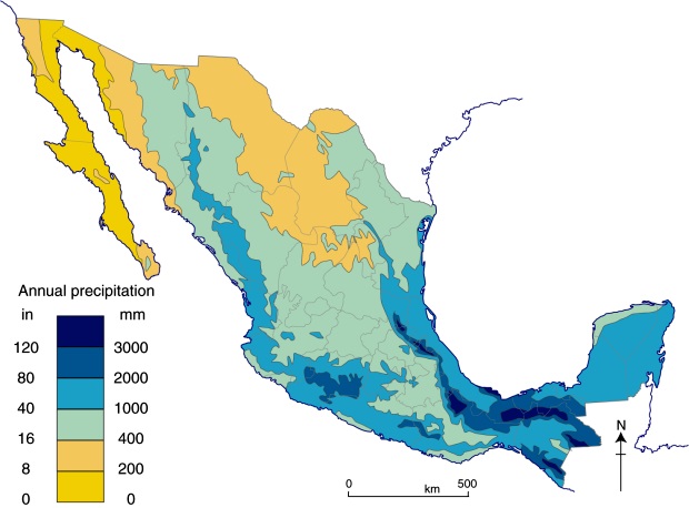
Annual precipitation in Mexico (Fig .4.3 of Geo-Mexico, the geography and dynamics of modern Mexico) All rights reserved.
The three main causes of precipitation in Mexico
Convectional rain is associated with hot afternoons. During the morning, warm air near the surface collects great quantities of moisture. As temperatures increase towards mid-day, pockets of moist warm air are sent upwards, quickly leading to condensation and clouds. As the clouds continue to rise, they cool to the point where precipitation becomes inevitable. Afternoon and evening rain showers result, often heavy and accompanied by thunder and lightening. Convectional rain occurs throughout Mexico but is a summer phenomenon since this is the time of year when solar radiation and ground heating is at a maximum. The effects of convectional rain are enhanced by the presence at that time of year over southern Mexico of the Intertropical Convergence Zone, a broad belt of generally rising air which migrates seasonally either side of the equator.
Orographic rainfall, the second type of rainfall, is associated with mountains. Mountains block the movement of clouds and force them to rise. This has a profound impact on precipitation. As the clouds rise, further condensation occurs and precipitation becomes extremely likely, as they cool to the point where they can no longer hold their moisture. Therefore, it rains a great deal on the windward or wet side of the range. By the time the air passes over the mountain range to the other side, it has lost much of its moisture. As it descends, it warms up and its relative humidity falls, so that there is little chance of any precipitation on the leeward side, known as the rain shadow.
For example, the summer north-east trade winds blow moist clouds from the Gulf of Mexico towards the Southern Sierra Madre and Chiapas Highlands. The eastern side of these mountains receives heavy rainfall. The mountain slopes in central Veracruz, eastern Oaxaca and parts of Chiapas have about 150 cloudy days and get about 2000 mm (80 in) of rain a year. However, the western slopes get only half as much rain and have only 90 cloudy days a year. Orographic precipitation sets virtually all the rainfall and snowfall records, even more than hurricanes. Tenango, Oaxaca is the rainiest place in Mexico; it receives about 5000 mm (16.4 ft) of rain each year. The orientation of mountain ranges is therefore critical to understanding precipitation patterns. The differences between windward and leeward sides of a mountain range can be very dramatic. For instance, El Chico and Pachuca in the state of Hidalgo are only 10 km apart but have 1500 and 400 mm of precipitation respectively each year.
The third type of rainfall is called cyclonic or frontal precipitation. This is the form of precipitation brought by the mid-latitude storms known as nortes, and the tropical storms that sometimes evolve into hurricanes. Nortes occur when the polar air behind a cold front displaces the warmer surface air, forcing it to rise as the cool air pushes its way underneath. At the surface, a sudden drop in temperature and the advent of cold winds marks the passage of the front, followed by several days of overcast skies with light rains or drizzle, onomatopoeically called chipichipis in some areas of Mexico.
Related posts
Sorry, the comment form is closed at this time.