This year marks the centenary of the start of the Mexican Revolution. One of the fundamental causes of the Mexico Revolution in 1910, though by no means the only one, was the demand by landless campesinos (peasant farmers) for access to the means to control their own supplies of food. Revolutionary leaders called for the expropriation of the large estates or haciendas, which had been the principal means of agricultural production since colonial times, and the redistribution of land among the rural poor. A law governing this radical change in the land tenure system came into force in 1917 and the process has continued, albeit sporadically, into modern times.
About half of all cultivated land in Mexico was converted from large estates into ejidos, a form of collective farming. In most ejidos, each individual ejidatario has the rights to use between 4 and 20 hectares (10-50 acres) of land, depending on soil quality and whether or not it is irrigated. In addition, members of the ejido share collective rights over the use of local pasture and woodland. The system is similar to that in place in Aztec times. The maximum area of land that hacienda owners were allowed to keep varied with its potential use, from 100 hectares in the case of irrigated arable land to 300 hectares for land without irrigation.
By 1970 land redistribution had been more or less completed. Even so, most farming land still remained in the hands of a very small minority of farmers. Only 1% of farms were larger than 5000 hectares (12,355 acres) but between them they shared 47% of all farm land. Meanwhile, 66% of farms were smaller than 10 hectares (25 acres) yet they shared only 2% of all farm land. The ejido system did not produce the anticipated increase in food production or food security. Hacienda owners opted to keep their most productive land, meaning that many ejidos had to work land that was marginal at best. Many ejidatarios saw no need to pursue profits provided their families were well fed.
Many individual plots were too small for mechanization, and nutrients were rapidly depleted through constant use. Collective ownership of the land meant that individuals could offer no collateral for improvement loans. Many campesinos abandoned their ejidos and sought their futures elsewhere, migrating either to the big cities, for their range of manufacturing and service jobs, or to the USA. A sizable proportion of ejido land is no longer economically productive, but only in the 1990s was any mechanism put in place for ejido lands to be sold and revert back to private status.
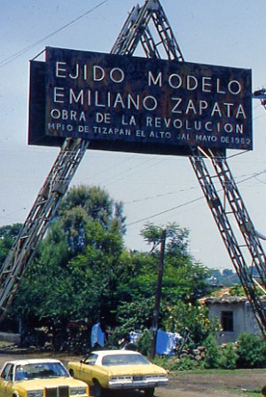
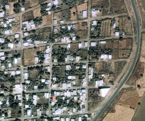
The photo shows the entrance to the “model ejido” of Emiliano Zapata, near Tizapán el Alto, Jalisco, on the southern shore of Lake Chapala. (nb. Despite the claims of Google Earth that this ejido is in the state of Michoacán, it is definitely in Jalisco, though relatively close to the state border.) The ejido has a population of about 2500. The Google Earth image clearly shows a dispersed rural settlement pattern, quite unlike the more usual nucleated villages of rural areas in most of Mexico. Each individual ejitario has a small plot of land around his/her house, and also has a share in the communal land beyond the perimeter of the settlement.
This is an excerpt from chapter 15 of Geo-Mexico: the geography and dynamics of modern Mexico. Buy your copy today, and learn more about Mexico’s fascinating geography. Additional knowledge will greatly enhance the pleasures you derive during your next trip to Mexico.
One Response to “The Emiliano Zapata Model Ejido near Tizapán el Alto in Jalisco”
Sorry, the comment form is closed at this time.


Hola!!! pues esta es mi tierra mi lugar de orijen y estoy muy horgullosa de ser de aki.