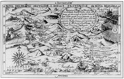
One of the earliest known maps engraved in colonial New Spain (Mexico) was that drawn by Antonio Ysarti in 1682. It shows the Franciscan Province of San Diego of Mexico, with its 14 friaries, from Oaxaca in the southeast to Aguascalientes in the northwest. It covers the archdiocese of Mexico City, as well as the dioceses of Puebla and Oaxaca to the east, and Michoacán and Guadalajara to the west.
The beautifully-drawn map was originally published to illustrate Baltasar de Medina’s 1682 Chronica de la Santa Provincia de San Diego de Mexico, printed by Juan de Ribero. In the words of the sellers of this map’s original copper plate to the Library of Congress, “This artifact is tangible evidence of an emerging scientific and artistic community in a growing colonial empire.”
Sadly, very little is known about Antonio Ysarti, the map’s talented cartographer; not even his nationality is known for certain.
The map measures 29 x 19 cm approx (11.25 x 7.25 inches) and names more than 50 places. Each friary is depicted as an architecturally distinct building, not by the use of a common symbol.
Q. How well do you know central Mexico? Click on the map above (to reveal the section between Mexico City and Acapulco) and then see how many places you can identify and match to present-day place names.
Online version of this map, offering the ability to zoom in to specific parts
The changing political frontiers of Mexico are the subject of chapter 12 of Geo-Mexico: the geography and dynamics of modern Mexico, a handy reference guide to all aspects of Mexico’s geography. If you have enjoyed this post, please consider gifting a copy of Geo-Mexico to someone in the coming holiday season.
One Response to “Beautiful cartography from the seventeenth century: Ysarti’s 1682 map of New Spain”
Sorry, the comment form is closed at this time.

awesome stuff