Much of northern Mexico experiences either an arid (desert) climate (less than 250 mm [10 in] of rain/year) or a semiarid (semi-desert) climate (250–750 mm [10–30 in] of rain/year). Areas with an arid (desert) climate (see map) include most of Baja California and western Sonora (together comprising the Sonoran desert), as well as the northern section of the Central Plateau (the Chihuahuan desert). These areas can experience frost and freezing during the winter.
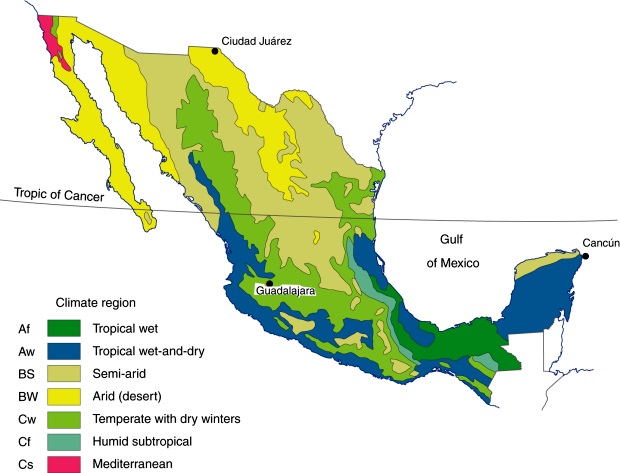
Major climate regions in Mexico. (Fig 4-5 of Geo-Mexico, the geography and dynamics of modern Mexico). All rights reserved.
Areas of semiarid (dry steppe) climate include most of the Central Plateau as well as western sections of the Western Sierra Madre, northern Yucatán and scattered inland areas as far south as Oaxaca. The rains in this region fall mostly in the summer, and localized heavy thunderstorms are quite common. The southern parts of this climatic region are warmer than the northern parts. (Mexico’s seven climate regions)
Why do parts of northern Mexico receive very little precipitation, making them deserts?
The major reason is that the zone between the Tropic of Cancer (latitude 23.5 degrees N) and latitude 30 degrees N is influenced by the Hadley Cell. This is the name given to the atmospheric circulation in tropical regions, named after George Hadley, the English amateur meteorologist who first proposed its existence, in 1735.
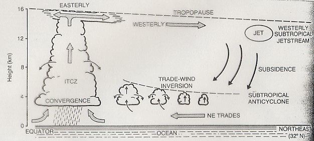
The functioning of the Hadley Cell
The Hadley Cell is the driving force behind many aspects of Mexico’s weather and climate. How does it operate? Solar heating is at a maximum near the equator and diminishes towards the poles. The area near the equator is the Intertropical Convergence Zone or ITCZ (see diagram). The heating of the ITCZ makes the air there rise, leaving an area of low pressure on the surface. This low pressure sucks in air along the earth’s surface from the subtropical high pressure areas about 30 degrees N and S of the equator creating the trade winds. The trade winds pick up moisture and latent heat over the oceans before converging from either side of the equator in the ITCZ. As the air in the ITCZ rises vertically, its water vapor condenses and rain falls from the towering convective clouds. This is the ascending limb of the Hadley cell. At a height of 10–15 km above the surface, the air, now minus its moisture, returns polewards as high level anti-trade winds. Sunbathers on Mexican beaches who notice two sets of clouds above them at different heights traveling in opposite directions are witnessing the trade winds and anti-trade winds in action.
In the subtropics, this air then descends again towards the surface to complete the cell and initiates the surface trade winds again. The descending air warms up as it sinks; its relative humidity decreases, and so no precipitation occurs; hence these high pressure subtropical areas are arid. Mexico’s arid and semiarid areas coincide with the descending air segment of the Hadley Cell and these high pressure subtropical areas.
In addition, the climate of the west coast of the Baja California Peninsula is influenced by the cool Californian current, which flows towards the south. The relative humidity of the air above it drops as the current enters warmer waters, so it is not likely to bring rain to the peninsula.
The aridity of the Sonoran desert is also partly due to its position in the rain shadow of the Western Sierra Madre. The Chihuahuan desert is in an even more marked rain shadow, protected by both the Western Sierra Madre and the Eastern Sierra Madre.
Stunning stream patterns in northern Baja California
Photographer Adriana Franco from Querétaro has taken several truly stunning artistic images of stream patterns in the semi-arid region of northern Baja California (near Mexicali). The photos, taken from an ultralight, show the details of the dendritic (= tree-like) stream patterns in this region. Dendritic stream patterns are common worldwide, but these images are exceptional. In general, dendritic stream patterns are associated with relatively gentle gradients where the underlying rocks are similar throughout the drainage basin.
Related posts
Sorry, the comment form is closed at this time.