The map below shows a regional division of Mexico by precipitation regime (the amount and seasonal distribution of precipitation). The small graph for each region shows the typical average precipitation amounts for each month of the year. (For example, region A has most precipitation in the first three or four months of the year, and very little after that). The map comes from Ernesto Jáuregai’s 1970 article about wind and water erosion in Mexico (full reference is given below).
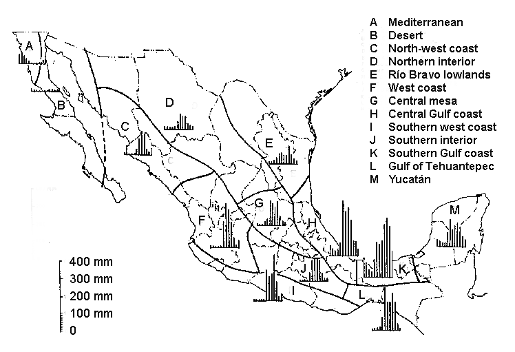
Precipitation regimes in Mexico (Fig 2 of Jáuregai 1970)
It is clear from the map that the distribution of precipitation across Mexico is very uneven. In general the north and central plateaus are dry while the southeast receives by far the most rain. Parts of Tabasco, Northern Chiapas and Veracruz get over 4000 mm (160 in) of rain a year. This is a direct effect of the onshore north-east trade winds, which collect moisture as they cross the Gulf of Mexico and then deposit it as they reach land.
Average annual rainfall figures conceal great differences from one year to the next. In general, the variability of rainfall is indirectly proportional to the long-term average. This means that areas with low totals tend to experience high variability, greatly increasing their drought hazard.
The map also reveals that there is a marked seasonality to precipitation in almost all of Mexico, with a clear division into a wet and a dry season. Most places get almost all their rain between June and October, while January through May are dry months. Because most rainfall is in the summer months, about 71% of rainfall evaporates soon after falling. This figure can be even higher in urban areas. Only about 26% runs off into rivers and lakes, and 3% seeps down to recharge subterranean aquifers.
One apparent anomaly to the pattern shown on the map is that the extreme north-west corner of Baja California (region A) has a Mediterranean climate where summers are dry and most rain falls in winter. Elsewhere in Mexico winter months are relatively dry. Southern and central Mexico have markedly dry winters, receiving less than 5% of their annual precipitation totals in the first three months of the year. The northern half of Mexico and the eastern coastal strip, including the Yucatán peninsula, have slightly more balanced precipitation, receiving between 5 and 18% of annual totals between January and March.
Map reference:
Ernesto Jáuregai. 1970. “La erosión hidráulica y eólica en México y sus efectos en las estructuras hidráulicas y en los núcleos de población.” UNAM: Boletín del Instituto de Geografía, Vol III, pp 39-60.
Related posts
2 Responses to “When does it rain in Mexico?”
Sorry, the comment form is closed at this time.
Hello,
I`m afraid that the link under “Related posts”: Expected impact on Mexico of global climate change- Leads to “The wettest states in Mexico” http://geo-mexico.com/?p=1088.
I think our rainfall in NL was practically zero after H. Alex on 1/2 July 2010 until just recently. So almost 3 years without rain.
Thanks for pointing out the link error which has now been corrected. Hope the recent rains herald the start of a rainy season that being the drought in your region to an end.