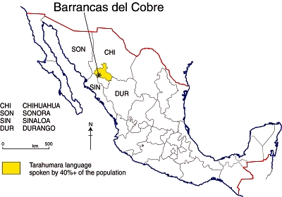
The Copper Canyon region in Mexico is the informal name for the area, in the south-west part of Chihuahua state, where several deep canyons bisect the Sierra Tarahumara. The 10,000 km2 area, part of the Western Sierra Madre, is home to about 50,000 Tarahumara Indians, one of the largest native Indian groups in North America. While generally referred to in English as the Tarahumara, the people’s own name for themselves is “Raramuri“, literally “the light‑footed ones” or “footrunners”.
While the Tarahumara have so far succeeded in keeping many aspects of their distinctive culture relatively unadulterated, the pressures on them have increased considerably in recent years as improving highway links have made the region more accessible, not only to tourists, but also to developers looking to exploit the region’s forest and mineral resources.
Spanish-speakers usually refer to this region as the “Barrancas del Cobre” (Copper Canyons, plural). The table shows the seven main canyons, only one of which, strictly speaking, is the Copper Canyon. The precise number of canyons depends on whether they are defined by rivers or by local names since different stretches of canyon along a single river have sometimes been given different names.
| Canyon | Elevation at the rim (meters / feet a.s.l.) | Elevation of stream in canyon floor (meters / feet) | Depth (meters/feet) |
|---|---|---|---|
| Canyons south and east of railroad | |||
| Urique (south of Urique village) | 2370 / 7775 | 500 / 1640 | 1870 / 6135 |
| Sinforosa (Río Verde) | 2530 / 8300 | 700 / 2300 | 1830 / 6000 |
| Batopilas | 2500 / 8200 | 700 / 2300 | 1800 / 5900 |
| Urique (mid-point, aka Copper Canyon) | 2300 /7545 | 1000 / 3280 | 1300 / 4265 |
| Canyons north and west of railroad | |||
| Candameña (below Basaseachi Falls) | 2540 / 8330 | 900 / 2950 | 1640 /5380 |
| Chinipas | 2000 / 6560 | 400 / 1310 | 1600 / 5250 |
| Oteros | 2220 / 7280 | 700 / 2300 | 1520 / 5980 |
The major canyon is the Urique Canyon. This is the one seen by most tourists because it is the closest to the railway line that traverses the region. Both the Urique River and the Batopilas River flow into the River Fuerte, which enters the Gulf of Mexico near Los Mochis.
Tarahumara place names
The Tarahumara have very few place-names. They do not usually have identifying names for specific mountains, streams, trails or landmarks , but do give names to every small settlement, even if it only consists of two or three homes. These names serve to distinguish one family from another, but a single family may have several farms, each with a different name. The Tarahumara do have “a rather complete terminology for plants, animals, and birds.” [Bennet & Zingg, 1935] The place-names for settlements are usually two-part names, consisting of a descriptive name plus a place suffix.
Examples include:
- Aworítci, from aworíki, “cedar tree” (tci gives idea of a grove of trees).
- Wisarótici, from wisaró, “poplar tree.”
- Tcimétabo, from tcimáka, “leather money bag”, plus –tabo, place-ending.
- Wagítali, from wagítci, “dead tree.”
- Garitcí, from garíki, “house.”
- Kusárare, from kusáka, “eagle.”
In future posts, we will delve further into the geography of the Copper Canyon region and the lifestyle of the Tarahumara Indians.
Sources:
Bennett, W. and Zingg, R. (1935) The Tarahumara. Univ. of Chicago Press. Reprinted by Rio Grande Press, 1976. Classic anthropological work.
Gajdusek, D.C. (1953) “The Sierra Tarahumara” in Geographical Review, New York. 43: 15‑38
Schmidt, R.H. (1973) A Geographical Survey of Chihuahua, monograph #37 Texas Western Press.
Related posts:
- Cultural and eco-tourism in the Copper Canyon region
- Mexico’s Copper Canyon train is one of the world’s great railway trips
- Mexico’s Copper Canyon is one of the world’s most amazing natural wonders
- Map of the State of Chihuahua
- Can the Tarahumara Indians who live in Mexico’s Copper Canyon region survive?
