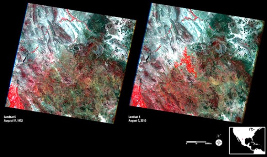
A recent article on Wired.com drew my attention to these spectacular Landsat photos of Chihuahua, Mexico.
- Link to high resolution Landsat images (clicking on the images in this link reveals amazing detail)
These false-color remote sensing images were taken by the Landsat 5 satellite in August 1992 (left) and August 2010 (right).
- Red = vegetation (the brighter the red, the healthier the vegetation)
- Whites, greens, browns = areas with bare soil or only limited vegetation (colors depend on organic matter and moisture content)
- Blue & Black = water (clear, deep water is darker; sediment-laden water is lighter)
- Blue-Gray = urban areas
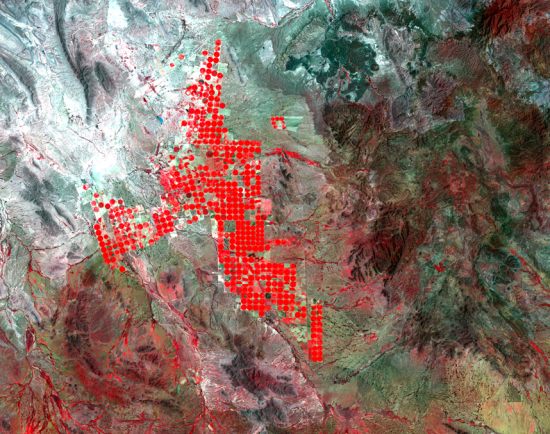
They show some interesting changes have taken place in the 18 years since the first image was captured. In particular, they reveal that more water is now available from a major reservoir, and is being used for irrigation. Particularly noticeable is the development of round irrigation areas in the central part of the images. These circular areas, which show as bright, red circles (see image below) are the result of center-pivot irrigation systems. The water is being used for growing alfalfa and sorghum to feed livestock.
In addition to the impacts resulting from irrigation, diverting more water from the reservoir has also affected the area’s native vegetation, and reduced the amount of water flowing into the Río Grande River. This may have ameliorated, at least slightly, the serious flooding which occurred earlier this year in the same general area.
- For more satellite images: USGS Landsat Website


Sorry, the comment form is closed at this time.