The impact of NAFTA on urban growth in Mexico

 Other  Comments Off on The impact of NAFTA on urban growth in Mexico
Jun 192010
 

The North American Free Trade Agreement (NAFTA), signed in 1994, had a significant impact on the pace and pattern of urbanization in Mexico.

NAFTA removed tariffs on imported corn and beans.  Small Mexican producers could not compete with the cheap imports from the USA. As a result, an estimated 1.3 million agricultural jobs in Mexico were lost. Many of those who lost work in rural areas, moved to Mexican cities or to the USA to search for employment. Most of these drifted into the urban informal sector in cities throughout Mexico.

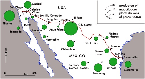
Geo-Mexico, figure 20.2

Geo-Mexico, figure 20.2 All rights reserved.

On the plus side, NAFTA created an estimated 500,000 jobs in Mexican manufacturing, mostly maquiladora assembly plants focused on the US market. These plants and their multiplier impacts generated rapid growth in border cities, particularly Ciudad Juárez, Tijuana, Mexicali, Matamoros, Nuevo Laredo, and Reynosa (see map).

Largely as a result of NAFTA, border cities grew faster during the 1990s than most other Mexican cities, essentially reversing the trend that existed during the 1980s. Though after 2000 many of Mexico’s border maquiladora industries moved to lower cost countries, most border cities continued to grow rapidly.

In conclusion, the overall NAFTA impact has strongly stimulated urban growth while fostering rural decline and out-migration.
Mexico’s ten largest cities (2009)

 Other, Teaching ideas  Comments Off on Mexico’s ten largest cities (2009)
Feb 202010
 

Mexico’s ten largest cities (2009 population) are:

  1. Mexico City          19,982,000 (Metropolitan Area)
  2. Guadalajara          4,365,000
  3. Monterrey             3,986,000
  4. Puebla                  2,647,000
  5. Tijuana                 1,784,000
  6. Toluca                  1,775,000
  7. León                     1,555,000
  8. Cuidad Juárez      1,408,000
  9. Torreón                1,187,000
  10. San Luis Potosí   1,037,000

[Figures taken from Table 21.2 of Geo-Mexico: the geography and dynamics of modern Mexico.]

Teaching idea:
1. Plot the location of these cities on a blank map of Mexico
2. Show the relative sizes of the cities in a way which is clear to the viewer. Use some form of proportional representation, and justify your choice.
3. Describe the resulting pattern of Mexico’s ten largest cities. (For instance, are they mainly in the central part of the country, the south, the north, or…?)
4. Suggest some possible reasons for the pattern you have described.