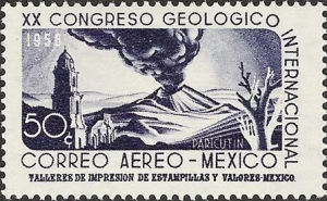
Paricutín first erupted, completely unexpectedly, in the middle of a farmer’s field, on February 20, 1943.
A remarkable account of its early days is given by Simón Lázaro Jiménez, who recounts in his book, Paricutín: 50 Years After Its Birth , his adventures as a young boy as he fled with his parents for safety as their small village of Angahuan was bombarded with red-hot rocks and ash. Don Simón’s account, which I was delighted to translate into English, may possibly be exaggerated in places, but remains the only first-hand account of any substance written by a native P’urépecha speaker.
The book is illustrated with some magnificent photos by German photographer Walter Reuter. One of Reuter’s photos shows Dionisio Pulido (the farmer whose field was blown apart by the volcano) trying to sell the resulting conical hill to an “eccentric American”. I have since learned that the “eccentric American” is none other than Robert Ripley of “Believe it or not” fame.
The volcano finally stopped erupting in 1952, but only after completely destroying the village of Parícutin (note that the position of the accent has changed over the years) and the town of viejo (old) San Juan Parangaricutiro. All that is left of the latter today are a few broken-down walls and parts of the huge, old church that did a brave job of withstanding the compelling force of the lava as it overran the rest of the town.
Geographic tongue-twister related to Paricutín Volcano.
The landscape around Paricutín is world-class in terms of its eco-tourism potential. Visitors have the opportunity to explore some of the finest, easily accessible volcanic scenery anywhere in the world. What makes Paricutín so special is that scientists have rarely had the opportunity to study a completely new land-based volcano, whereas new oceanic island volcanoes are comparatively common. In fact, the first two new volcanoes formed in the Americas in historic times are just one hundred kilometers apart. The first is Jorullo, which first erupted on September 29, 1759, and was studied by Alexander von Humboldt; the second is Paricutín.
Mexico’s Volcanic Axis is discussed in chapter 2 of Geo-Mexico: the geography and dynamics of modern Mexico. The sustainable forestry project of San Juan Parangaricutiro is examined in chapter 15 and the 2004 UN Equator prize won by the village is described here.
Copies of Paricutín: 50 Years After Its Birth are available from Sombrero Books

Sorry, the comment form is closed at this time.