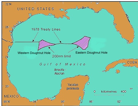
In 1970, the UN Law of the Sea Convention formally awarded each country the right to natural resources in its 200-mile (322 km) Exclusive Economic Zone (EEZ). Where claims overlapped, the Law of the Sea requires the competing countries to negotiate separate bilateral or multilateral agreements.
By 1979, the US and Mexico had agreed a treaty governing the basic delimitation of their respective EEZs. However, the treaty was never ratified by the US Senate. While the treaty had fixed seven points on the boundary, there were still two areas where the countries’ claims overlapped. The two portions were called the Western and Eastern Polygons (or Gaps), but were quickly nicknamed the Doughnut Holes. Together they straddle about 200 km of border.
The Western Doughnut Hole has a surface area of 17,467 square kilometers (6,744 square miles). The Eastern Doughnut Hole is about 20,000 square kilometers (7,720 square miles) and partially overlaps with the EEZ of Cuba.
 To date, no deposits of hydrocarbons have yet been found which straddle the maritime boundary, even though the Western Doughnut Hole is thought to hold untapped reserves of oil and gas. However, oil wells on one side of the boundary would likely extract some oil from the other side, hence the potential for conflict. In a parody of US politician Ross Perot’s famous 1992 line about the likely impact of the North American Free Trade Agreement (NAFTA) which would cause “a giant sucking sound” as US jobs moved south to Mexico, Mexican journalists have described the likely result of drilling in the Doughnut Hole as a “giant sucking sound” as US firms used their superior deep-water technology to suck up Mexican oil from the other side of the border.
Presidents Calderón and Obama agreed in May 2010 to extend the moratorium on any oil exploration drilling in the Western Polygon until January 2014, giving both sides time to hold joint discussions towards a permanent agreement.
The major oil spill from Deepwater Horizon has helped drive both governments to prioritize joint regulations governing oil and gas activities close to their shared border. Discussions are expected to cover not only deep water oil extraction, but also shallow water activities, including resources other than oil and gas.
For more details, see these two articles by Javier H. Estrada Estrada, Analitica Energética S.C.:
- Reservoirs that cross country lines need special agreements
- Trans-boundary oil and gas fields between Mexico and the USA (pdf file)
The changing political frontiers of Mexico are the subject of chapter 12 of Geo-Mexico: the geography and dynamics of modern Mexico. Oil reserves and exploitation are discussed in chapter 15. If you have enjoyed this post, please consider purchasing a copy of Geo-Mexico so that you have your own handy reference guide to all aspects of Mexico’s geography.
Sorry, the comment form is closed at this time.