Is the south shore of Lake Chapala in Jalisco or in Michoacán?

 Maps, Mexico's geography in the Press  Comments Off on Is the south shore of Lake Chapala in Jalisco or in Michoacán?
Aug 242022
 

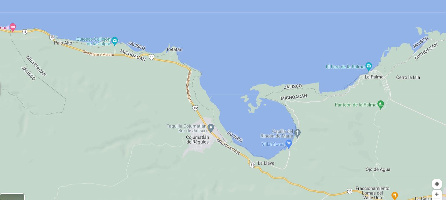
According to Google Maps, the entire southern shore of Lake Chapala belongs to Jalisco, not Michoacán . . .
– Según Google, toda la orilla sur del lago Chapala pertenece a Jalisco, no a Michoacán . . .

The south shore of Lake Chapala according to Google Maps (2022)

Google might want to alert Mexico’s mapping and statistics agency, INEGI, to that ‘fact.’

Google knows best? Not always!!

Mar 152022
 

The answer appears to be a resounding “No!” This article in the Guardian explains why:

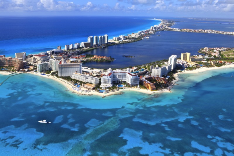
And what’s true for Cancún is likely to be true for almost all the beaches in Quintana Roo along Mexico’s Caribbean coast.

Cancún by Arthur Gonoretzky (Flickr)

Cancún by Arthur Gonoretzky (Flickr)

Related posts:

Nov 262020
 

We have frequently published international comparisons showing how Mexico fares in comparison with other Latin American countries and major world economies for a wide variety of indicators.

Reliable comparisons for comparing countries on their Covid-19 response have been hard to come by, but here is a link to one compiled by Bloomberg News:

As the article concludes, Mexico’s response to Covid-19 does not bode well for future economic progress. Nor does it bode well for reducing economic and social disparities within Mexico.

Stay safe!

Review of “Poor Economics: A Radical Rethinking of the Way to Fight Global Poverty”

 Books and resources, Mexico's geography in the Press  Comments Off on Review of “Poor Economics: A Radical Rethinking of the Way to Fight Global Poverty”
Oct 292019
 

In honor of the award of the 2019 Nobel Prize for Economics to Abhijit Banerjee, Esther Duflo and Michael Kremer for their experimental approach to alleviating global poverty, we republish this post from five years ago in which we highlighted the significance of the pioneering work of Banerjee and Duflo:

Every so often a book comes along that shakes up established wisdom and forces us to rethink our viewpoints and beliefs. The latest such book to cross my desk is Poor Economics: A Radical Rethinking of the Way to Fight Global Poverty by Abhijit V. Banerjee and Esther Duflo, published by PublicAffairs in 2011.

Geo-Mexico is reader-supported. Purchases made via links on our site may, at no cost to you, earn us an affiliate commission. Learn more.
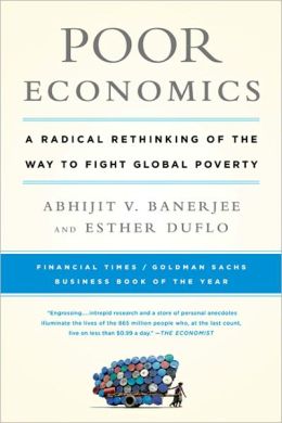
poor-economicsThis is a worthy read for anyone interested in development theory, policy, practice and economics. The authors are professors of Economics at the Massachusetts Institute of Technology (MIT) and co-founded the Abdul Latif Jameel Poverty Action Lab (J-PAL). Their book reports on the effectiveness of solutions to global poverty using an evidence-based randomized control trial approach.

Banerjee and Duflo argue that many anti-poverty policies have failed over the years because of an inadequate understanding of poverty. They conclude that the battle against poverty can be won, but it will take patience, careful thinking and a willingness to learn from evidence.

The authors look at some of the unexpected questions related to poverty that empirical studies have thrown up, such as :

  • Why do the poor (those living on less than 99 cents a day) need to borrow in order to save?
  • Why do the poor miss out on free life-saving immunizations but pay for drugs that they do not need?
  • Why do the poor start many businesses but do not grow any of them?

The book was supported by an outstanding website that included:

  • Introductions to each chapter
  • Maps showing cited studies with links to original sources
  • Data and figures used with interactive data tools
  • A “What Can You Do” page with links to major organizations working in the field or for the problem discussed in the chapter

The website’s links to research papers mentioned in the book included four studies related to Mexico:

1. Do Conditional Cash Transfers Affect Electoral Behavior? Evidence from a Randomized Experiment in Mexico, by Ana L. De La O.

The evidence comes from the pioneering Progresa, the original Mexican conditional cash transfer (CCT) program (since repackaged as Oportunidades).  This CCT program led to a 7% increase in turnout and a 16% increase in the  incumbent vote share, with clear implications for politicians in areas where CCT programs reach a large percentage of voters.

2 School Subsidies for the Poor: Evaluating the Mexican Progresa Poverty Program, by T. Paul Schultz of Yale University (August 2001).

This study considered how a CCT program affected school enrollment. The CCT program increased enrollment in school in grades 3 through 9, with the increase often greater for girls than boys. The cumulative effect was estimated to add 0.66 years to the baseline level of 6.80 years of schooling.

3 Experimental Evidence on Returns to Capital and Access to Finance in Mexico, by David McKenzie and Christopher Woodruff (March 2008)

Microenterprises are often unable to access suitable financing, even though they are responsible for employing a large portion of the total workforce. This experiment, which gave cash and in-kind grants to small retail firms, demonstrated that this additional capital generated large increases in profits, with the effects concentrated on those firms which were more financially constrained. The estimated return to capital was found to be at least 20 to 33 percent per month, three to five times higher than market interest rates.

4 Working for the Future: Female Factory Work and Child Health in Mexico, by David Atkin (April 2009)

Atkins’ paper found that children whose mothers lived in a town where a maquiladora (export factory) opened when the women were sixteen years old were much taller than those children born to mothers who did not have a similar opportunity. The effect was so large that “it can bridge the entire gap in height between a poor Mexican child and the “norm” for a well-fed American child.” (Poor Economics, 229)

The increase in height could not be fully explained by the changes in family income resulting from employment in a maquiladora. As Bannerjee and Duflo suggest, “Perhaps the sense of control over the future that people get from knowing that there will be an income coming in every month -and not just the income itself- is what allows these women to focus on building their own careers and those of their children. Perhaps this idea that there is a future is what makes the difference between the poor and the middle class.” (Poor Economics, 229)

Conclusion

Banerjee and Duflo’s positive message is that poverty can indeed be alleviated, but we need to take one small measurable step at a time with constant evaluation of whether or not particular policies are successful, based on evidence, not just on belief systems.

Poor Economics: A Radical Rethinking of the Way to Fight Global Poverty” deserves its place of honor alongside other such genuine classics as E.F. Schumaker’s “Small Is Beautiful: A Study of Economics As If People Mattered” (1973). It is a must-read for geographers, regardless of your political persuasion.

Note: this is a lightly edited version of a post first published 27 January 2014.

Related posts
Aug 232019
 

A recent edition of the New Scientist has an interesting article about dinosaurs and the rapid shifts in our knowledge of these ancient beasts based on recent fossil discoveries. If the New Scientist is to be believed, these discoveries have not only revolutionized our views of dinosaurs, they have also rearranged the Earth’s geography.

  • The demise of the dinosaurs came about after “An enormous asteroid struck what is now the Yucatan peninsula  in Central America, sparking a mass extinction.”

Hmm… first up, it should be the “Yucatán Peninsula” (with an uppercase “P”) to refer to that region of Mexico. And, more importantly, the Yucatán Peninsula, as part of Mexico, is clearly in North America, not Central America, unless the impact of that danged asteroid is still reverberating around the world and shifting the continents.

For more about dinosaurs and the Chicxulub impact crater –

Source:

  • Riley Black. “The undiscovered dinosaurs”. New Scientist, August 3-9, 2019, page 46

Ten new “Magic Towns” have been announced

 Mexico's geography in the Press  Comments Off on Ten new “Magic Towns” have been announced
Oct 122018
 

Ten new “Magic Towns” have been announced, bringing the total number nationwide to 121. The lates additions are:

  • Melchor Múzquiz, Coahuila
  • Nombre de Dios, Durango
  • Comonfort, Guanajuato
  • Zimapán, Hidalgo
  • Tlaquepaque, Jalisco
  • Compostela, Nayarit
  • Amealco de Bonfil, Querétaro
  • Aquismón, San Luis Potosí
  • Bustamante, Nuevo León
  • Guadalupe, Zacatecas

See also:

Incoming administration has decentralization plans

 Mexico's geography in the Press  Comments Off on Incoming administration has decentralization plans
Oct 022018
 

Several previous administrations have tried to decentralize Mexico, encouraging businesses to set up in the “periphery” away from the “core” of Mexico City and central Mexico. The incoming administration has announced its intention to move several federal government Secretariats away from Mexico City. The plans are discussed in some detail in this interesting article by Simon Schatzberg:

Aug 282018
 

For anyone who continues to doubt the potentially disastrous impacts of building a wall along the U.S.-Mexico border on wildlife (let alone people), then perhaps these two articles will help you decide which side of the fence you want to be on:

See also:

New museum in Yucatán will explain Chicxulub Crater and demise of the dinosaurs

 Mexico's geography in the Press  Comments Off on New museum in Yucatán will explain Chicxulub Crater and demise of the dinosaurs
Feb 132018
 

A new museum 40 kilometers northwest of the Yucatán state capital – Mérida – is expected to open later this year to explain the nearby Chicxulub Crater, created by an asteroid impact 65 million years ago, and believed to be responsible for the demise of the dinosaurs.

Spectacular landscapes in Mexico

 Mexico's geography in the Press  Comments Off on Spectacular landscapes in Mexico
May 112017
 

We rarely post straight links to other sites without detailed commentary but every rule has exceptions and this spectacular selection of 30 Google Earth images from The Atlantic more than deserves a close look:

Previous visually-stunning or visually-interesting posts on Geo-Mexico include:

Mar 292017
 

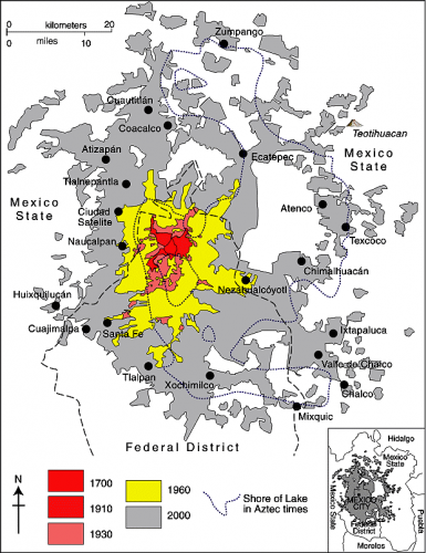
In 2009 Feike de Jong walked the entire perimeter of Mexico City to capture the strange scenery of its fringes. The 800-km trek took him 51 days.

Mexico City Metropolitan Area (Geo-Mexico Fig 22.2; all rights reserved)

Spatial growth of Mexico City Metropolitan Area (Geo-Mexico Fig 22.2; all rights reserved)

These two Guardian articles tell the story of his trip:

The author’s ebook Limits: On Foot Along the Edge of the Megalopolis of the Valley of Mexico, with the full story and more images, is due to be released later this year.

Enjoy!

Want to learn more about Mexico City?

Oct 202016
 

Mexican market research firm Gabinete de Comunicación Estratégica polled 30,400 people across the country to compile its 10th annual survey of the most livable cities in Mexico. The survey was carried out by telephone between 30 June and 19 July this year. Respondents in Mexico’s 60 most populous municipalities and Mexico City’s 16 delegaciones were asked a series of questions related to quality of life and level of services provided in each city. [Given the sample size, at a confidence level of 95% the maximum expected error for each municipality was ±4.9%]

most-livable-cities

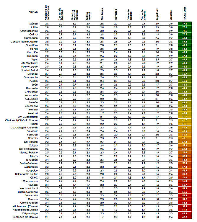
The survey looked at numerous variables to quantify “quality of life”, including housing, schools, mobility, air pollution and employment. The survey also considered satisfaction with services, and satisfaction with the performance of the city’s mayor.

best-living-in-citiesFor quality of life, the top ranking city overall, for the second year running, was Mérida (Yucatán), which scored 77.6 points out of 100, followed by Saltillo (77), Aguascalientes (71.6), Colima (70.9) and Campeche (69.8). Monterrey came in 12th in the survey rankings (see table), while Guadalajara placed in the middle.

The four least livable cities in the study were Villahermosa (52.9), Naucalpan (51.3), Chilpancingo (49.8) and Ecatepec (48.8).

  • Full report: Ciudades más habitables de México 2016 (pdf)

Related posts:

Mexican architect proposes city straddling Mexico-U.S. border

 Mexico's geography in the Press  Comments Off on Mexican architect proposes city straddling Mexico-U.S. border
Oct 032016
 

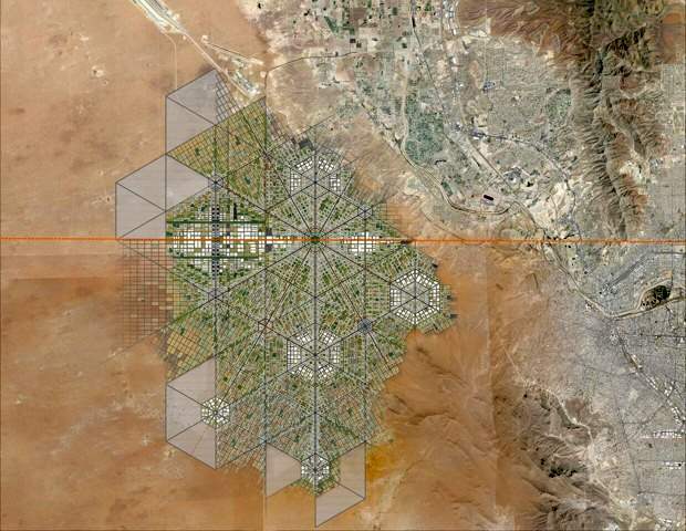
This proposal sounds a lot more 21st century than Trump’s plan for a wall along the Mexico-U.S. border. Will either proposal ever actually happen? Most likely not. But that does not prevent us from considering the former project one more than worthy of mention here.

Young Mexican architect Fernando Romero has long believed that “building bridges” is preferable to creating obstacles and that conventional boundaries “are just becoming symbolic limits.”Romero was named a “Global Leader of Tomorrow” at the World Economic Forum in 2002.

Masterplan for trans-border city. (Fernando Romero Enterprise)

Masterplan for trans-border city. (Fernando Romero Enterprise)

To illustrate his viewpoint, Romero recently released a master plan for a walkable, super-connected metropolis straddling the U.S.-Mexico border. More than a decade ago, Romero’s architecture firm proposed a tunnel-like “Bridging Museum” crossing the Mexico-U.S. border in the Rio Grande Valley. His more recent suggestion of a utopian border city, presented at the London Design Biennale, is far more ambitious and would take advantage of the concept of special economic zones (employed earlier this year by Mexico’s federal government to stimulate development in several southern states).

To read more about this exciting proposal, with numerous stunning images of what it might look like, see “Instead of Trump’s Wall, Why Not a Binational Border City?

For more about the U.S.-Mexico border zone, see these related Geo-Mexico posts:

Which are the best states in Mexico for doing business in 2016?

 Mexico's geography in the Press  Comments Off on Which are the best states in Mexico for doing business in 2016?
Sep 232016
 

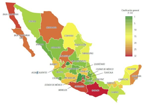
A study just released by the World Bank and the International Finance Corporation, Doing Business en México 2016, compares Mexico’s 32 states for the paperwork, time and costs associated with four major indicators: opening a new business, obtaining construction permits, registering industrial property rights and the resolution of commercial disputes.

The report concludes that the seven best states in which to do business are Aguascalientes, the State of Mexico, Colima, Puebla, Sinaloa, Guanajuato and Durango, all of which offer a better performance than the average for OECD high income countries.

doing-business-2016-fig-1-2

Overall ranking for Doing Business in Mexico 2016 (Source: Fig 1-2 of World Bank Report)

The three states that have advanced the most towards implementing international best practices since 2014 are Puebla, Jalisco and the State of México.

The map shows the rank order of states for doing business, from green (the best) to red (the lowest ranking). Unlike many maps of state-by-state performance, this map does not show any evidence for the north-south divide we have repeatedly commented on in the past.

Related posts:

Hidden Beach, aka Beach of Love, reopens

 Mexico's geography in the Press  Comments Off on Hidden Beach, aka Beach of Love, reopens
Sep 012016
 

Mexico’s famed Hidden Beach (Playa Escondida), aka as the Beach of Love (Playa del Amor), has reopened for limited tourism following a three month closure  for cleaning and restoration work.

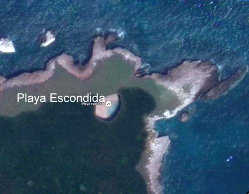
The beach is on one of the small, uninhabited Marieta Islands, in the Marieta Islands National Park, off the west coast of Mexico, and relatively close to the resort of Puerto Vallarta. It is one of Mexico’s most beautiful small beaches, looking from the air (image) like an “eye to the sky”.

Playa Escondida. Source: Google Earth. Scale: The beach is about 30 m (100 ft) long.

Playa Escondida. Source: Google Earth. Scale: The beach is about 30 m (100 ft) long.

In earlier posts, we considered how Playa Escondida (“Hidden Beach”) was formed and also looked at the not inconsiderable downside to publicizing one of Mexico’s most beautiful beaches.

After a study by University of Guadalajara researchers found that local coral was dying and argued that the beach could support no more than 625 visitors a day (compared to the estimated 2500 who visit it on vacation days), federal authorities closed the beach and prohibited access while they considered how best to regulate future visits.

Mexico’s National Protected Areas Commission (Conanp) has now announced new regulations governing visits to the island and to the beach. It is limiting visitors to 116/day, well below the University of Guadalajara figure for carrying capacity of 625/day/.

In addition, no single group may have more than 15 members. No diving is allowed. Fins, face masks and snorkels are all prohibited. Visits have a strict time limit of 30 minutes. The beach, visted by more than 125,000 in 2015, will be completely closed two days each week for maintenance and monitoring.

Only time will tell if these measures will be sufficient to ensure that this particular gem of Mexico’s hundreds of amazing geosites will still be there for future generations to admire and appreciate.

Related posts

Plans afoot for several mini-refineries in Mexico

 Mexico's geography in the Press, Updates to Geo-Mexico  Comments Off on Plans afoot for several mini-refineries in Mexico
Aug 292016
 

State-owned Pemex currently has six oil refineries in Mexico, which process around 1.05 million barrels/day (b/d) of crude.

The company has now shelved plans to add a $10-billion refinery at Tula (Hidalgo) owing to doubts about its long-term viability. It does seem that it is unlikely to be needed since Mexico’s energy reforms have led to several private companies submitting proposals to build less expensive, modular “mini-refineries” in Mexico. Each of these mini-refineries is 80-90% smaller than any of the six giant Pemex refineries.

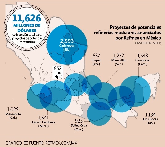
Planned new refineries. Credit: El Economista / Refmex.com.mx

Planned new refineries. Credit: El Economista / Refmex.com.mx

A consortium of U.S. firms, Refinerías Unidas de México (Refmex), plans to invest 11.6 billion dollars to build 9 mini-refineries, starting with a $1.5billion refinery in Campeche with the capacity to refine between 40,000 and 60,000 b/d. Construction would take between 18 and 30 months.

Other proposed locations (map) include Cadereyta (Nuevo León), Dos Bocas (Tabasco), Minatitlán (Veracruz), Lázaro Cárdenas (Michoacán), Manzanillo (Colima), Salina Cruz (Oaxaca), Tula (Hidalgo) and Tuxpan (Veracruz). Several of these locations are in the recently announced federal Special Economic Zones, which offer fiscal incentives to investors.

Related posts:

The continuing revitalization of Acapulco

 Mexico's geography in the Press  Comments Off on The continuing revitalization of Acapulco
Aug 082016
 

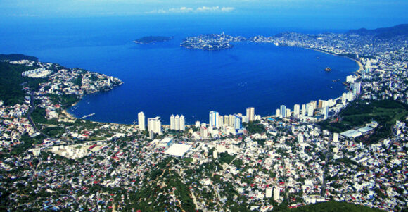
Acapulco is busy re-invigorating its tourist industry. In recent months, we’ve looked at the city’s improved public transit system known as Acabús and reported the news that Acapulco International Airport is getting a new, state-of-the-art, 18,800-square feet terminal building. The airport’s operator, Grupo Aeroportuario del Centro-Norte (GACN) says the 30-million-dollar terminal will be capable of handling 1.3 million passengers a year.

acapulco-bay-prob-public-domain

Now, Mexican firm Mundo Imperial, the tourist division of the vehicle financing firm Grupo Autofin, has announced a 1-billion-dollar Master Plan to help revitalize Acapulco, Mexico’s first jet set resort.

The plan aims to return the city to its former glory days by renovating the famed Mundo Imperial, Fairmont Princess and Pierre Marqués hotels, and adding several smaller boutique hotels and a medical center, as well as up-market homes and a high-end shopping plaza.

The project also includes an additional 700-room hotel, new tennis stadium, a hospitality training facility and an eco-adventure park. The plan, which will create around 10,000 jobs in total, will take five years to complete.

According to tourism officials, Acapulco’s reactivation as a tourist center is well under way. They claim that the port resort will host more than 40 major conferences this year, and that the city will be a port-of-call for more than 30 U.S. cruise ships.

Next year, Acapulco will once again host Mexico’s massive annual Tourism Fair, the Tianguis Turístico.

Related posts:

Instant poverty reduction – just change the baseline

 Mexico's geography in the Press, Updates to Geo-Mexico  Comments Off on Instant poverty reduction – just change the baseline
Jul 282016
 

The latest report on poverty from the National Statistics Agency, INEGI, looks like good news for Mexico’s poorest people but, sadly, this is only a mirage, based on a change in the measurement methods used.

The 2015 edition of INEGI’s Survey of Socioeconomic Conditions showed an overall real increase of 11.9% in household earnings, with an increase of over 30% in some states. According to the report, Mexico’s poor are richer by a third compared to last year, a change that some politicians will no doubt claim is the direct result of their effective policies.

Social activists were stunned by the claims of poverty reduction and Mexico’s National Council for the Evaluation of Social Development Policy (CONEVAL), which measures poverty levels using INEGI’s data, said the changes by the statistics institute were not credible.

According to Jonathan Heath, an independent economic researcher in Mexico City, Inegi is claiming that the previous methods overestimated poverty levels, but the change in methodology, without public consultation, “raises suspicion.”

Quite apart from the misleadingly positive spin on numbers, the change in methodology makes it completely impossible to compare current poverty rates with the rates for previous years.

Related posts:

Jul 252016
 

We drew attention a few years ago to the issue of Empty houses in Mexico, a problem due in part to on-going rural-urban migration, and in part to the construction of millions of new homes across Mexico. Thirty years ago, there were only 15 recognized metropolitan areas in Mexico, today there are 59.

Poor coordination between the various government departments responsible for housing, services and land development has led to some settlements being authorized even in areas where ownership was disputed or that lacked adequate access to highways or basic services.

Three years ago, a Mexico City news report entitled Desorden urbano dejó en el país millones de viviendas fantasmas claimed that as many as 4 million houses, many of them newly built, were standing empty. Other houses have been abandoned for a variety of reasons, ranging from the death of former owners, or owners moving to other areas, or being unable to keep up with mortgage and loan payments.

Infonavit Housing. Credit: Habitat D.F.

Infonavit Housing. Credit: Habitat D.F.

News reports claim that as many as 14 houses in a single street are abandoned in some areas, such as the Mineral de la Reforma district of the rapidly-growing city of Pachuca in the state of Hidalgo, causing problems for neighbors.

Now, the Mexican Workers’ Housing Fund, Infonavit, has set itself the target of reclaiming 30,000 abandoned houses this year. Infonavit has funded hundreds of developments with small, cookie-cutter houses, across Mexico. Members of Infonavit can access a series of housing-related mortgage products, to buy or remodel a new or existing home.

Starting last year, Infonavit began to rescue abandoned houses, renovate them and then auction them off to its members. Initial success was limited, with only about half of the repossessed homes being sold on, but in the first few months of this year, Infonavit has successfully sold off 92% of the first 3,000 houses it has recovered.

This year, Infonavit plans to auction off homes in Chihuahua, Nuevo León, Tamaulipas, Hidalgo and the State of México.

Related posts:

Mexican business association tries to counter rhetoric of U.S. political campaigns

 Mexico's geography in the Press  Comments Off on Mexican business association tries to counter rhetoric of U.S. political campaigns
Jul 142016
 

Mexico’s Business Coordination Council (Consejo Coordinador Empresarial, CCE) has launched a publicity drive to counter the disinformation and anti-Mexican rhetoric emerging in U.S. political campaigns. The details of the publicity drive remain unclear.

Juan Pablo Castañón, CCE’s president, says the aim is to emphasize the true strength and importance of good Mexico-U.S. relations. In particular, the NAFTA trade zone accounts for 15% of global trade, 28% of global GDP and 14% of FDI flows. Trade between the three partners has quadrupled since 1993 and exceeded a trillion dollars in 2015, half of which is attributable to U.S.-Mexico trade.

Mexico is the second most important destination for U.S. exports and the main market for exports from California, Arizona, New Mexico and Texas. Goods worth 500 million dollars cross the border daily.

According to Castañón, if U.S. politics puts a brake on this trade, more than six million U.S. workers could lose their jobs. Proposed tariffs on imports of flat screens and vehicles would raise prices significantly in the USA. In addition, 80% of avocados and 50% of tomatoes sold in the USA come from Mexico.

Related posts

World’s smallest porpoise on brink of extinction

 Mexico's geography in the Press  Comments Off on World’s smallest porpoise on brink of extinction
Jul 112016
 

One year on from when we last reported on the desperate plight of Mexico’s “little sea cow”, the endangered vaquita marina, where are we now?

According to the World Wildlife Fund, “The vaquita is at the edge of extinction”. The latest population estimate suggests that the number of vaquita in the wild has fallen from about 100 in 2014 to just 60 today, despite a much-publicized ban on fishing in the main area where the little sea cows are found.

As we reported in Mexico’s “little sea cow” on the verge of extinction two years ago, the sea cow’s fate is inextricably tied to fishing for the (also endangered) totoaba, a fish in demand in China for its swim bladder, which is believed to have medicinal properties. Fishermen in Mexico’s Gulf of California (Sea of Cortés) are reported to have been offered more than $4,000 for a single totoaba bladder, which weighs only 500 grams. The price in China is reported to be between $10,000 and $20,000 each.

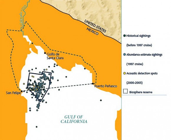
Map of sightings and acoustic detection spots. Adapted from North American Conservation Action Plan for the vaquita

Map of sightings and acoustic detection spots. Adapted from North American Conservation Action Plan for the vaquita

In April 2015, federal authorities imposed a two-year ban on gillnets and expanded the vaquita protection area to cover 13,000 square kilometers (5,000 square miles) of the upper Gulf of California . Some 600 gill nets (each of which can be up to # meters long) were seized by the Mexican Navy in 2015 (and 77 individuals detained), and navy personnel claim they are still confiscating nets every day.

The International Committee for the Recovery of the Vaquita (CIRVA) is trying to make a difference. Among the options being considered by Mexico’s Environment Secretariat (Semarnat) is assisted breeding, though a vaquita expert, Barbara Taylor of the U.S. National Oceanic and Atmospheric Administration, is quoted in The Guardian as claiming that “We have no idea whether it is feasible to find, capture and maintain vaquitas in captivity much less whether they will reproduce. The uncertainties are large.” The World Wildlife Fund Mexico is currently opposed to such a strategy, given the very low number remaining.

Mexico has had conservation successes in the past, allowing the populations of other marine animals, including the Guadalupe fur seal and the northern elephant seal, to recover.

Related posts:


Acapulco airport to get a new terminal building

 Mexico's geography in the Press  Comments Off on Acapulco airport to get a new terminal building
Jul 072016
 

Acapulco international airport (ACA), in Guerrero state, currently handles about 800,000 passenger movements each year. The airport is operated by Grupo Aeroportuario del Centro-Norte (GACN), which also manages airports in another 12 cities. With suitable fanfare in 2014, GACN announced plans to replace the terminal building.

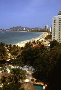
Acapulco, Mexico's first major resort. Photograph by Tony Burton. All rights reserved.

Acapulco, Mexico’s first major resort. Photograph by Tony Burton. All rights reserved.

Last month, GACN reiterated it is investing $30.5 million to build a new terminal building for Acapulco capable of handling 1.3 million passengers a year. The group claims that the new terminal, which will be more than 18,000 square meters in area, will have a state-of-the-art design that will reduce the risks associated with natural hazards and provide much greater space for passengers, airlines and all other supporting services. In addition, it will adopt a range of electricity-saving measures, lowering the airport’s regular operating costs.

Now scheduled to be completed by mid-2018, the Acapulco terminal is the most significant single investment that GACN plans to make in the next five years, and comes at a time when city authorities are busy revitalizing the famous resort. An improved public transit system known as Acabús was officially inaugurated in the city in June 2016.

The new terminal will, however, no longer be ready in time for 2017, when Acapulco will once again host Mexico’s massive annual tourism trade fair, the Tianguis Turístico.

Related posts:

Yet another tourism megaproject, this time in Nayarit

 Mexico's geography in the Press  Comments Off on Yet another tourism megaproject, this time in Nayarit
Jun 272016
 

Despite some recent setbacks to hotel projects planned for the Caribbean side of Mexico, hotel building continues to gather pace elsewhere in the country, seemingly regardless of the long-term advantages and ecological value of retaining an undisturbed, or minimally-disturbed, coastline

In April, at Mexico’s major tourism trade fair, the Tianguis Turistico, in Guadalajara, authorities announced the go-ahead for Costa Canuva, a $1.8 billion tourism project in the state of Nayarit. The project is a joint venture between the federal tourism development agency, Fonatur, and Portuguese construction firm Mota Engil.

Costa Canuva is in the municipality of Compostela, and is situated about 65 km (40 mi) north of Puerto Vallarta international airport and will be under three hours driving time from Guadalajara once the new Guadalajara-Puerto Vallarta road is completed.

The 255 hectares (630 acres) of beach, estuary and mountains involved in Costa Canuva has 7 kilometers (4.3 mi) of beachfront, and was designated by Fonatur several years ago as the site for a purpose-built resort. The original version of the project, which never got off the ground, was known as Costa Capomo.

The revamped project, Costa Canuva, will add five hotels and more than 2,500 homes to this stretch of coast known as Riviera Nayarit. The first phase, expected to take three years and create more than 2,000 direct jobs, includes a luxury Fairmont Hotel, residential areas, and a golf course designed jointly by golf supertars Greg Norman and Lorena Ochoa.

The master plan for the project includes a beachfront village with 2,500 residential units, more than 20 kilometers of cycling tracks designed by the International Mountain Bicycling Association and an adventure park featuring canopy rides and ziplines.

The centerpiece Fairmont hotel will have 250 guestrooms and suites, more than 22,000 square feet of meeting and event space, six restaurants and bars, an expansive outdoor swimming pool and a massive spa, as well as a center for children and young adults.

Related posts:

Jun 232016
 

At the Mexico-China Forum for Cooperation in Mexico City in May 2016, authorities from China’s Guangdong Province met with Mexican officials and discussed plans to invest in Mexico’s recently-established Special Economic Zones.

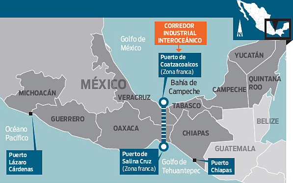
special-economic-zones

These zones offer tax benefits and support services to investors in order to generate new sources of employment in southern Mexico (Guerrero, Oaxaca, Chiapas, Michoacán, Veracruz and Tabasco).

Trade between Guangdong Province and Mexico was worth $10.4 billion last year, 25% of the two countries’ total trade. Chinese firms are considering projects related to aerospace, vehicles, electronics and energy, which could add $480 million in foreign direct investment. In support of closer ties between Mexico and China, China Southern Airlines plans direct flights between Guangdong and Mexico starting next year, which would serve business travelers and also boost tourism.

Good news for Mexico’s marine turtles and terrestrial tortoises

 Mexico's geography in the Press  Comments Off on Good news for Mexico’s marine turtles and terrestrial tortoises
Jun 062016
 

On Mexico’s Pacific coast, the endemic Green Turtle or tortuga verde (Chelonia mydas) has been taken off the “endangered” list and had its status reclassified as “threatened”. Despite the success of conservation efforts in Mexico, green turtle remains on the worldwide endangered list, to which it was first added in 1978.

For details of Mexico’s conservation efforts with respect to sea turtles, see Protecting Mexico’s endangered marine turtles.

The global population of green turtles, which can wiegh up to 200 kg and live as long as 80 years, has now been divided by wildlife experts into 11 distinct sub-populations, allowing some flexibility in approaches to their management.

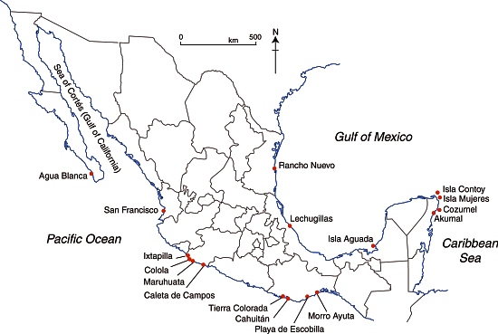
Selected marine turtle nesting beaches in Mexico.

Selected marine turtle nesting beaches in Mexico.

Meanwhile, in Mexico’s arid northern interior in the Chihuahuan desert, biologists have reported a marked upsurge in the numbers of the very much smaller Bolson tortoise. The Bolson tortoise (Gopherus flavomarginatus), native to this part of Mexico, is often referred to as the Mexican giant tortoise, but grows only to about 50 cm in length, with a weight of around 18 kg. It had been under threat due to local people hunting it for food, and due to shifting weather patterns. The tortoise is one of the various endangered species inhabiting the Bolsón de Mapimi, the desert basin that straddles the borders of Durango, Coahuila and Chihuahua.

Conservation efforts in the area have focused on ensuring that local people have an alternative source of meat (cattle in this case) and appreciate the value of preserving their native tortoises. Local communities have been given grants to help with reforestation projects, environmental monitoring and maintaining a small museum for visitors.

Related posts:

Grupo México plans to mine copper in Monarch Butterfly reserve

 Mexico's geography in the Press  Comments Off on Grupo México plans to mine copper in Monarch Butterfly reserve
May 262016
 

Mexico’s largest mining company, Grupo México plans to mine copper from its mine in Angangueo, Michoacán, according to the town’s mayor, Leonel Martínez Maya, who says it would revitalize the local economy. Large-scale mining in the town declined after a serious accident in 1953, said to have been attributable to the company’s then-foreign management in response to a threatened strike. The miners who lost their lives in this accident are commemorated by a huge statue which overlooks the town.

Angangueo. Sketch by Mark Eager; all rights reserved.

Angangueo. Sketch by Mark Eager; all rights reserved.

The mayor is adamant that the renewal of active mining in the town would have no adverse consequences for the annual migration of Monarch butterflies (who overwinter in their tens of millions in the pine-fir forests above the town)  or on their habitat.

The town is one of Mexico’s “Magic Towns” and the area is a protected natural reserve, but apparently the mining company is taking advantage of a legal loophole and arguing that the mine predates the establishment of the Monarch reserve, and that the mine was never technically closed, even though it was inactive in recent years. The Michoacán state government is said to support the Grupo México initiative.

Despite boom times in the past, the town of Angangueo currently has only limited sources of revenue other than seasonal tourism.

The illustration and parts of the description come from chapter 30 of my Western Mexico, a Traveller’s Treasury (4th edition, 2013).

Related posts:

The race is on to expand 4G-LTE services in Mexico

 Mexico's geography in the Press  Comments Off on The race is on to expand 4G-LTE services in Mexico
May 092016
 

AT&T and Telcel are competing for the concession of 80 megahertz (MHz) of spectrum for the provision of 4G-LTE mobile broadband service in Mexico. The winner is expected to have to pay somewhere in the region of 700 million dollars to the government in order to acquire the rights.

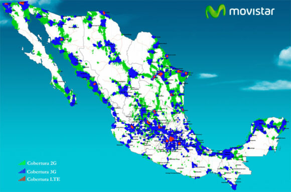
Movistar coverage, 2G, 3G, 4G - 2016

Movistar coverage, 2G, 3G, 4G – 2016

The three major competitors currently in the 4G-LTE market in Mexico are Movistar (Telefonica), Telcel (America Movil), and AT&T.

Telcel is the dominant player and reaches 65 million users nationwide. Movistar serves about 50 cities (see map). AT&T’s 4G-LTE network currently reaches 40 million people in 36 cities, but the firm is investing aggressively, with plans to reach 75 million people by the end of 2016 and 100 million by 2018. Under construction is AT&T’s new 300-million-dollar operations center in Guadalajara, which will benefit from that city’s well-qualified workforce and enhance its importance as Mexico’s tech sector hub.

Related posts:

Female Mexican diplomat to head U.N. climate framework

 Mexico's geography in the Press  Comments Off on Female Mexican diplomat to head U.N. climate framework
May 052016
 

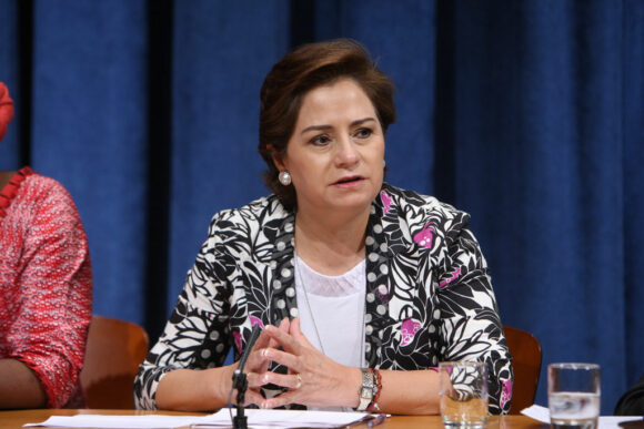
United Nations Secretary-General Ban Ki-moon has started the process of consultation with the Conference of Parties through its Bureau, and announced his intention to appoint Patricia Espinosa Cantellano of Mexico as Executive Secretary of the United Nations Framework Convention on Climate Change (UNFCCC).

Espinosa

Espinosa. Credit: UN Photo: Devra Berkowitz

Ms. Espinosa Cantellano has more than 30 years of experience at highest levels in international relations, specializing in climate change, global governance, sustainable development and protection of human rights.

Since 2012, she has been serving as Ambassador of Mexico to Germany, a position she also held from 2001 to 2002. She previously served as Minister of Foreign Affairs of Mexico from 2006 to 2012.

[Text of UN press release, 3 May 2016]

Apr 282016
 

Like most geographers, I collect maps and information wherever I travel; you never know what surprises await. Tourism publications are especially interesting since they are specifically designed (one assumes) to show the best side of the places described.

My collection of tourist brochures associated with Jalisco and the Lake Chapala area dates back more than thirty years. Many early versions had stylized maps, drawn by graphic designers, not cartographers, with sound (if uninspiring) text in Spanish. English translations were often unintelligible. In the 1980s, several bilingual members of the now-defunct Association of Travel Reporters, based in Guadalajara, offered to help the Jalisco State Tourism Department improve its translations, but the offer was politely declined.

chapala-brochure-2016

As this latest brochure relating to Lake Chapala shows, translation standards have not improved significantly since then, and remain a long way off “native speaker” level. This is particularly unfortunate, given that this area of Mexico has the largest concentration of English-speakers in the country.

Here, for example, is the English translation of the attractions of San Juan Cosalá:

One has to closely experience San Juan Cosalá in order to feel and enjoy it to the most, so come and discover a place you will never want to leave, for every happy moment can be lived here, as just by visiting you feel enveloped in an affluent of joy and vitality.

In getting to know it, just stroll across its Pier, or admire the harmonious architecture in San Juan Evangelista Church, or enjoy the exquisite aromas of seafood, bouncing from restaurants enlivened with fine music while walking over the Piedra Barrenada (Drilled Stone); or the rest;  freshness and fun offered in thermal waterparks and world level spas.

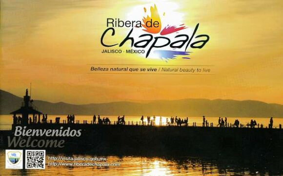
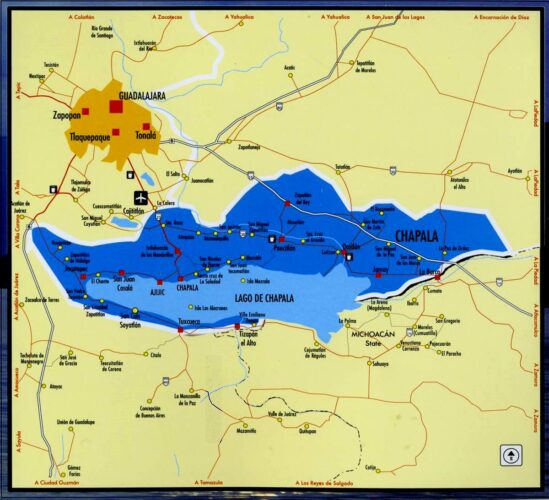
Undated tourism brochure, collected April 2016

Undated tourism brochure, collected April 2016

The cartography (above) also leaves a lot to be desired. A key (not shown in this post) is provided but the Jalisco Tourism department clearly needs to hire a geographer if they want to publish useful and meaningful maps. Details worth noting include:

  • No symbol in the key for the “gas station” signs shown on the map. The map shows only four gas stations in this area (and none in Chapala or Ajijic); there are dozens of others not shown on the map, including several in Chapala and Ajijic.
  • The map has no scale.
  • The Isla de los Alacranes, a short boat-ride from Chapala, is shown a long way south of its true position, and a lot further from Chapala than it really is.
  • The dark blue area is, according to the key, the Chapala Lakeshore. I have absolutely no idea what it really represents! Lake Chapala’s catchment area is a completely different shape to the dark blue area. The “Chapala Lakeshore” should, obviously, also include the south-east section of the lake around Las Palmas and Cojumatlán. Much of the area colored dark blue is out of view of the lake, and drains towards the Santiago River, not the lake.
  • Placing the word “CHAPALA” in the north-east section of the dark blue area is totally misleading. The area where the word is written is NOT in the lake basin, not in view of the lake, and is not even in the municipality of Chapala. Again, I have no idea why the artist responsible for this map chose to ignore geography.

It is 2016, and Jalisco State tourism officials still need to improve the quality of their brochures and maps. Come on guys! Time to up your game!