Energy reforms and Mexico-USA Transboundary Hydrocarbons Agreement

 Mexico's geography in the Press, Updates to Geo-Mexico  Comments Off on Energy reforms and Mexico-USA Transboundary Hydrocarbons Agreement
Jan 302014
 

Mexico recently approved the most significant energy reforms since the nationalization of the oil industry in 1938. The reforms end the 75-year monopoly over the energy industry enjoyed by state oil giant Petroleos Mexicanos (Pemex), opening the way for private investment in petroleum exploration and production.

The proposals do not allow foreign ownership of mineral or oil resources, but do allow private sector firms to participate in refineries and distribution networks, as well as sign profit-sharing contracts with state oil giant Pemex and the Federal Electricity Commission. The reforms include a revised tax regime for Pemex, the world’s fifth-leading oil producer, and its reorganization into two subsidiaries.

Mexico’s oil production has risen recently to 2.5 million barrels/day (b/d) and is expected to reach 3 million b/d by 2018.

The Mexico-USA Transboundary Hydrocarbons Agreement (THA) has been approved by senators in Washington. The accord allows both countries to explore and develop crude reserves that straddle their exclusive economic zones in the Gulf of Mexico. It establishes “an environmentally safe and responsible framework to explore, develop, and share revenue from hydrocarbon resources that lie in waters beyond each country’s exclusive, economic zones,” according to White House National Security Council spokesperson Caitlin Hayden.

location of doughnut holes

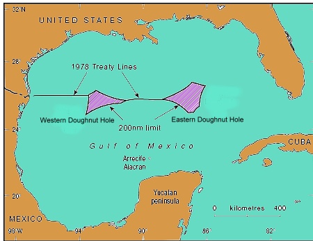
The two “doughnut holes” where Mexican and US Exclusive Economic Zone claims overlap

The American Petroleum Institute has hailed the possibility of Mexico-USA joint projects in the Gulf of Mexico. The reserves in the maritime boundary region are believed to total more than 170 million barrels of oil and 15 million metric tons of natural gas, according to the U.S. Department of the Interior’s Bureau of Ocean Energy Management.

Related posts:


Pemex boosts reserves and reduces its emissions

 Mexico's geography in the Press, Updates to Geo-Mexico  Comments Off on Pemex boosts reserves and reduces its emissions
Dec 032012
 

It may come as something of a surprise to many observers, but during 2012, Mexico’s state-owned oil company Pemex (Petróleos Mexicanos) has received several well-deserved plaudits for its efforts to slash the emissions associated with oil and gas exploration, reserves and production.

For the fifth consecutive year, the Global Reporting Initiative awarded Pemex the highest possible rating for social responsibility. The company also received excellent ratings for sustainable asset management. During 2011, Pemex’s proven reserves increased 1.1%, while the petro-giant cut total emissions by 17.3% compared to the previous year. Crude oil output averaged 2.55 million barrels a day in 2011. Carbon dioxide emissions were down 8.8% in 2011, while sulfur oxides have now fallen more than 50% since 2007.

Meanwhile, the production division of Pemex has been praised by World Bank experts for having reduced burn-off from its giant Cantarell gas field from 31% in 2008 to 3% in July 2011. Pemex has invested more than 1.6 billion dollars in the Cantarell field over the last six years in order to improve efficiency, with the installation of compressors, flow separation devices and re-injection technology. In the past three years, it has reduced total emissions, including greenhouse gases, from 13.6 billion cubic meters a year to 2.1 billion. Pemex is well on track to beat its target of 99% efficiency in gas recovery by 2014.

Crude oil production has risen steadily in 2012. For example, in August 2012, Pemex produced 2.56 million barrels of oil a day (b/d), its highest output since May 2011. The Chicontepec field in Veracruz is doing especially well. Its single best-performing well, named Presidente Alemán 1565, uses innovative technology, including three dimensional seismic mapping and horizontal drilling, to yield as much as the combined output of 28 other wells in the region.

Mexico’s current 3P (proven, probable, possible) reserves are also on the rise, and currently total 43 billion barrels of crude oil equivalent. After years of depletion, Pemex is now adding more oil and gas each year to its reserves than it is extracting. The oil giant recently announced a huge deep water, light crude discovery in the Gulf of Mexico, off the coast of Tamaulipas, its first major find in the Perdido Fold Belt, where the total 3P reserves could be as high as 10 billion barrels. The Trión-1 well, drilled to a total depth of 4,500 meters (14,800 feet), is 40 km (25 miles) inside Mexico’s territorial waters and is expected to yield up to 400 million barrels of high quality crude.

Pemex also recently reported the largest land-based discovery of oil for about a decade. The Navegante-1 well, drilled in the South-East Basins 20 km from Villahermosa (Tabasco) found light crude oil with an APR gravity of 45 degrees, at a depth of 6800 meters. The field is 87 square kilometers in area and has estimated 3P reserves of about 300 million barrels of crude oil equivalent.

Related posts:


Aug 302012
 

Veteran blogger Matt Osborne has unearthed a real gem! This 1977 BBC documentary was the tenth episode of The Age of Uncertainty, John Kenneth Galbraith’s history of economic thought. In this episode, Galbraith examines the economics of poverty and inequality.

The section of greatest interest to Geo-Mexico readers is his overview of the changing relationships between land and people in Mexico from precolonial times to the 1970s. [This ten minute segment starts at minute 4:33 of the video].

Galbraith does confuse his Teotihuacanos with his Aztecs, and clearly many things have changed since 1977, but this video is a great and straightforward introduction to the complex issues of land resources and population, suitable as the starting point for many discussions at high school or college level about land clearance, the financing of land improvement, the Green Revolution, population growth and social organization.

Related posts:

Appropriate technology project supplies solar-powered stoves

 Other  Comments Off on Appropriate technology project supplies solar-powered stoves
Jul 262012
 

In a recent post, we mentioned a video on the Global Post website about transport developments in Mexico City. Global Post has published another short video in the same series, that is equally interesting and valuable as a teaching resource:

My first experience of a solar-powered stove was during an environmental education workshop in the state of Michoacán some 25 years ago. I was underwhelmed by its performance, but the more modern (and much more efficient) designs featured in this video definitely merit a much closer look.

The video focuses on the work of Gregor Schäpers, a self-taught solar engineer, and his company Trinysol, that makes solar-powered stoves and boilers. The company, located in the village of El Sauz in the state of Hidalgo, a short distance north-east of Mexico City, is a good example of the development of appropriate technology.

One of Trinysol’s first projects was working with a women’s cooperative in the village of  San Andrés, who produce a sweet  syrup from green agave plants. The process involves hours of cooking, and therefore requires a large input of energy. Prior to the installation of Scheffler reflectors and solar-powered hotplates, the women relied on gas.

Solar reflectors, San Andrés.

Schäpers has since set up hundreds of solar-powered boilers, and dozens of solar stoves in the region. Some are designed for individual families; others are suitable for small-scale industrial use, for example to provide energy for bakeries (panaderias) or tortilla-making plants (tortillerias).

According to the figures offered in the video, it costs about 4,000 dollars to build and install heating for a panadería, but can save the owners up to 5,000 dollars a year in energy costs. The investment is therefore fully recouped within a year. The system should last for 30 years, so a solar-powered system represents a significant improvement to the economics of many small businesses, giving them the opportunity to expand or allocate more of their scarce resources elsewhere.

Mexico and USA agree to talk about oil rights in the Gulf of Mexico’s “Western Doughnut Hole”

 Books and resources, Mexico's geography in the Press  Comments Off on Mexico and USA agree to talk about oil rights in the Gulf of Mexico’s “Western Doughnut Hole”
Nov 152010
 

In 1970, the UN Law of the Sea Convention formally awarded each country the right to natural resources in its 200-mile (322 km) Exclusive Economic Zone (EEZ). Where claims overlapped, the Law of the Sea requires the competing countries to negotiate separate bilateral or multilateral agreements.

By 1979, the US and Mexico had agreed a treaty governing the basic delimitation of their respective EEZs. However, the treaty was never ratified by the US Senate. While the treaty had fixed seven points on the boundary, there were still two areas where the countries’ claims overlapped. The two portions were called the Western and Eastern Polygons (or Gaps), but were quickly nicknamed the Doughnut Holes. Together they straddle about 200 km of border.

The Western Doughnut Hole has a surface area of 17,467 square kilometers (6,744 square miles). The Eastern Doughnut Hole is about 20,000 square kilometers (7,720 square miles) and partially overlaps with the EEZ of Cuba.

location of doughnut holesTo date, no deposits of hydrocarbons have yet been found which straddle the maritime boundary, even though the Western Doughnut Hole is thought to hold untapped reserves of oil and gas. However, oil wells on one side of the boundary would likely extract some oil from the other side, hence the potential for conflict. In a parody of US politician Ross Perot’s famous 1992 line about the likely impact of the North American Free Trade Agreement (NAFTA) which would cause “a giant sucking sound” as US jobs moved south to Mexico, Mexican journalists have described the likely result of drilling in the Doughnut Hole as a “giant sucking sound” as US firms used their superior deep-water technology to suck up Mexican oil from the other side of the border.

Presidents Calderón and Obama agreed in May 2010 to extend the moratorium on any oil exploration drilling in the Western Polygon until January 2014, giving both sides time to hold joint discussions towards a permanent agreement.

The major oil spill from Deepwater Horizon has helped drive both governments to prioritize joint regulations governing oil and gas activities close to their shared border. Discussions are expected to cover not only deep water oil extraction, but also shallow water activities, including resources other than oil and gas.

For more details, see these two articles by Javier H. Estrada Estrada, Analitica Energética S.C.:

The changing political frontiers of Mexico are the subject of chapter 12 of Geo-Mexico: the geography and dynamics of modern Mexico. Oil reserves and exploitation are discussed in chapter 15.  If you have enjoyed this post, please consider purchasing a copy of Geo-Mexico so that you have your own handy reference guide to all aspects of Mexico’s geography.

Mexico’s ecological footprint compared to that of other countries

 Other  Comments Off on Mexico’s ecological footprint compared to that of other countries
Feb 162010
 

The ecological footprint of a country  is defined as the area of land (and water) required by a population, given prevailing technology, to produce the resources it consumes and to absorb any wastes created.

Ecological footprints are measured in ‘global hectares’ (gha). A global hectare encompasses the average annual productivity of all biologically productive land and ocean areas in the world. In 2005 the world’s population required the resources of 2.7 gha /person.  Unfortunately, the world’s biocapacity—the amount of resources its ecosystems can supply each year—was only equivalent to 2.1 gha per person and is declining each year as population increases (see graph).

The deficit between biocapacity and our ecological footprint causes damaging environmental changes to forests, fisheries, rivers, coral reefs, soil, water and air, and plays a major role in global climate change. The figures mean that our current usage of the world’s resources is inherently unsustainable.

Click here for a printable bookmark of this graph (pdf file)

The graph shows the ecological footprint of several countries. China’s footprint matches global biocapacity while the footprints of India, Indonesia and Bangladesh are fully sustainable. On the other hand, the USA’s footprint of 9.4 gha is surpassed only by the United Arab Emirates. Australia and Canada both have footprints over 7 gha. In simple terms, their populations require more than three times their fair share of the world’s biocapacity.

Chapter 30 of Geo-Mexico: the geography and dynamics of modern Mexico, from which this extract is taken, looks in much more detail at the implications of ecological footprints and at alternative ways of assessing ‘sustainability’.