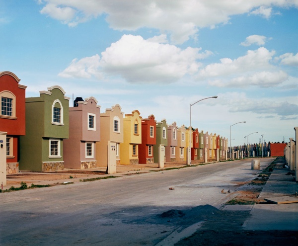
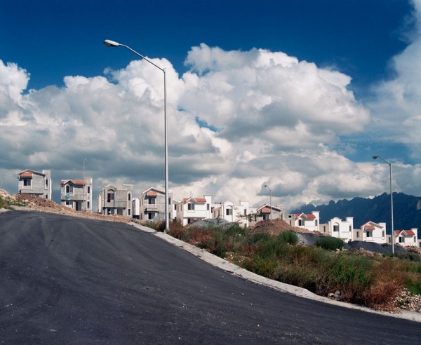
What do Mexican suburbs look like? What is their function? As the country’s towns and cities continue to expand, new suburbs appear on their outer edge. Some are gated communities, generally aimed at high income families; these suburbs sometimes include private schools and sports clubs. Other suburbs offer smaller homes aimed at low-income families.
Photographer Alejandro Cartagena lives in the Monterrey Metropolitan Area, which includes nine different municipalities in the state of Nuevo León: Monterrey, Guadalupe, San Nicolás, San Pedro, Santa Catarina, Escobedo, Apodaca, García and Juárez.
Cartagena spent years exploring the edge of the city to document the manifestations of “suburbia mexicana” through photographs. The suburbs he depicts are mainly low-income suburbs, some still being constructed. Cartagena recognized that change was happening at a very rapid pace, and often by developers with more lust for profit than desire to improve the local community. Since 2001, more than 300,000 new homes have been built in the Monterrey Metropolitan Area. Many suburbs were badly planned, as some of Cartagena’s photos clearly reveal. Considerations of roads, parks and public transport are often ignored in the decision-making of these developers.
“Suburbia mexicana” includes five series of images, each briefly described below. For fuller descriptions of Cartagena’s ideas, please use the links from the title of each series to visit his relevant section of his website:
Fragmented Cities explores what the homes look like, as if being photographed for a real estate brochure.
Lost Rivers looks at the “environmental problems that stem from excessive urban and suburban development such as dried up and polluted rivers and streams.”
The Other Distance attempts to “connect the wealthy with the new-middle and low class urbanization models” by looking at San Pedro Garza García, which is one of the richest municipalities in Mexico, and easily the wealthiest part of the Monterrey Metro Area. Quoting geographer David Harvey on the “inter-connectivity between urbanization and capital accumulation”, Cartagena explores the economic contrasts that have created two distinct spaces (based on wealth), one that lacks specific “social cohesion space” such as parks, not designed to take into account “infrastructure, hospitals or education centers”, and one occupied by the wealthy sectors of society where such things are considered their “right”. Cartagena recognizes that both these spaces have an interdependent symbiotic relationship.
Urban Holes depicts abandoned spaces in downtown Monterrey, so “highly overpriced by market speculation” that “investors look to un-urbanized land to create new developments that are lacking all kinds of infrastructure”.
The People of Suburbia, the final section, is based on a return to some of the areas photographed previously, including the municipality of Juárez, where urbanization has led to the population tripling since 2002. It is a “visual study of the unending capitalist endeavor of urban growth”.
In Cartagena’s own words, the photos of “suburbia mexicana” “depict a global issue from a local perspective” and one his intentions is “to point out the struggle our contemporary world faces between the ideals of capitalism and the striving and desire for fairer and more equal cities in which to live.” As such, this splendid collection of photographs certainly deserves the widest possible audience.
If you like Alejandro Cartagena’s work, you may like to know that he has published a book of “suburbia mexicana”, available via his website.
For more details about the Monterrey Metropolitan Area, see this 2008 paper by Dr. Peter Ward:


Sorry, the comment form is closed at this time.