Nuevo León’s unusual shape

 Other  Comments Off on Nuevo León’s unusual shape
Jan 032015
 

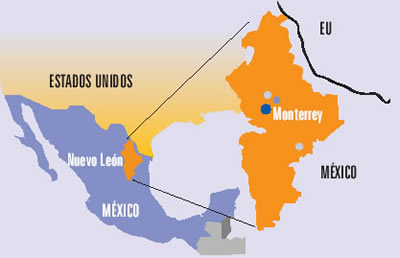
The northern state of Nuevo León is an industrial powerhouse, centered on Monterrey, Mexico’s third-largest city. The state’s shape on a map is unusual in more ways than one. The state has a long north-south axis and is very narrow from west to east. The strange indentation south of Monterrey is largely determined by relief. The peaks of the mountains on the Nuevo León side of that state boundary comprise a National Park, the Parque Nacional Cumbres de Monterrey.

Source: Universidad Autónoma de Nuevo León (UANL)

Source: Universidad Autónoma de Nuevo León (UANL)

Perhaps the strangest aspect of the shape of Nuevo León is the peculiar extension that forms the state’s north-eastern extremity (see map above). This small section of the state, about 15 km across, is sandwiched between the states of Coahuila and Tamaulipas, and extends to the Río Bravo and the U.S. border. The reason for this particular extension must date back a long time since it is clearly shown on this 1824 map of Mexico.

(Note that the shape of the neighboring state of Tamaulipas, with its lengthy extension north-west paralleling the US border, made much more sense in the early nineteenth century before the current international boundary was established).

While we’re not sure of the precise timing or reasons for the “neck” of land that gave Nuevo León access to the Río Bravo even before the current international boundary was fixed, it has certainly brought the state some benefit in recent decades in terms of economics and trade. Nuevo León is the smallest of the combined ten “border states” in the USA and Mexico.

A closer look at the Google Map image (above) of this area shows the border crossing of Laredo-Colombia across the Solidarity International bridge. Colombia is the name of the small grid-pattern town on the Mexican side, just west of the crossing.

Zooming in on the area of the crossing reveals the distinctive street pattern of a major border crossing, with extensive parking and loading areas.

The 371-meter-long (1216 ft) bridge has eight lanes for traffic and two walkways for pedestrians. It is one of four vehicular international bridges close to the city of Laredo, Texas. The community of Colombia and the international bridge were built to give Nuevo León its only international “port” for direct trade to and from the USA.

Related posts:

Three Mexican cities among the 100 most competitive cities in the world

 Mexico's geography in the Press  Comments Off on Three Mexican cities among the 100 most competitive cities in the world
May 072014
 

Three cities in Mexico – Mexico City Metropolitan Area, Monterrey Metropolitan Area and Querétaro – are included on the 2013 list of “The World’s Most Competitive Cities. A Global Investor’s Perspective on True City Competitiveness”, a report issued by Site Selection magazine in cooperation with IBM Global Business Services.

It is the first time the city of Querétaro (2010 population: 805,000) has been included on the list; Mexico City and Monterrey are old-timers on the list.

The 100 cities studied all have a minimum population of 1 million inhabitants in the local labor catchment area and attracted at least 25 foreign investment projects in 2009-2011. The study aims to rank the competitiveness of cities “to attract investment and international projects in various sectors”, and to identify those locations with the best combined “cost-quality” for particular types of investment project.

The report presents rankings and findings for five different types of operations:

  • International headquarters, coordinating corporate operations in a global region
  • Financial services center of competence
  • Software development center
  • R&D center for life sciences, combined with pilot production
  • Shared services center, providing support for corporate operations in finance, customer support, human resources or IT
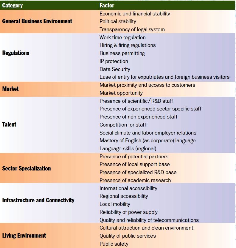
Criteria used to rank world's 100 most competitive cities

Criteria used to rank world’s 100 most competitive cities

Rankings are based on 30 factors or parameters (see chart above).

The most competitive cities in the world were London, U.K. (score of 78.0), Singapore (78.5), New York City (77.4), Amsterdam (76.3) and Hong Kong (75.9).

Mexico City Metropolitan Area was ranked as number 57, with a score of 55.8. Monterrey Metropolitan Area ranked number 72 (48.2) and Querétaro city ranked number 90 (43.6).

Related posts:

The growth of the city of Monterrey, Mexico’s industrial powerhouse

 Excerpts from Geo-Mexico, Other  Comments Off on The growth of the city of Monterrey, Mexico’s industrial powerhouse
Oct 282013
 

A series of historical maps of the city of Monterrey was published earlier this year in the city’s online Catalog of Buildings of Historic and Artistic Importance in Barro Antiguo, The maps, dated 1765, 1791, 1846, 1865, 1922, 1933 and 1947 respectively, offer a good basis for considering the urban growth of Monterrey, the industrial powerhouse of northern Mexico.

In chapter 22 of Geo-Mexico, the geography and dynamics of modern Mexico, we explained why, “Monterrey does not fit the general Latin American urban model as well as Mexico City or Guadalajara. First, it never really existed as a colonial city. Secondly, its development was more heavily dependent on industry. Thirdly, its relative wealth and progressive leadership in some ways make it more similar to a North American city than a Latin American city. It fits the model only in that it developed a definite high status sector in contrast to lower status industrial sectors, and eventually became spatially fragmented.”

But just how did Monterrey develop as a city? In each of the following historical maps of Monterrey, Barrio Antiguo (16 blocks in size in the present-day city) is marked by a red quarter-circle, which is an easy way to check each map’s orientation and scale. Monterrey was founded in 1596. The earliest map in our series, for 1765, shows that, even by that date, Monterrey was still a relatively small settlement situated between a (seasonally dry) “stream formed by various springs” (to the top of the map, north) and the seasonally-dry “Monterrey River” (now called the Santa Catarina River). The Barrio Antiguo is shown as mostly an empty area, with only one major construction.
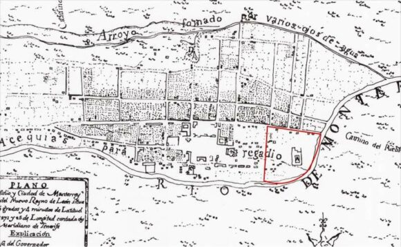
Monterrey 1765

Monterrey 1765

Very little has changed by 1791 (see map below: note that this map is oriented south-upwards), though the Barrio Antiguo has now been developed, and is shows as having several streets in a clear grid pattern:
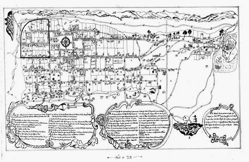
monterrey-1791

Monterrey in 1791

The grid pattern for Barrio Antiguo is equally evident in the details of the map in 1846:
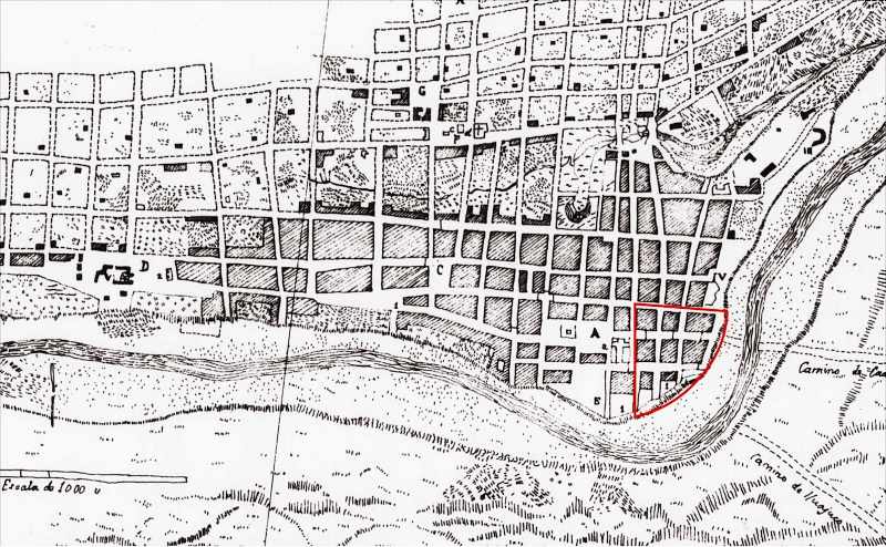
monterrey-1846

Monterrey in 1846

As of 1846, no development is shown on the south bank of the Santa Catarina River, though tracks are shown heading east and south-east respectively from the city. The next map, for 1865, shows that the city is beginning to expand to the south. A substantial settlement is developing on the south bank, more of less opposite the Barrio Antiguo. Note, though, that this map shows only part of the city:
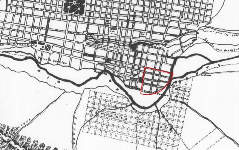
monterrey-1865

Monterrey in 1865

Clearly, Monterrey only emerged as a real city after the colonial period which ended in 1821. The relatively small city did not experience real growth until late in the 19th century when it became connected by railroad and started to attract industrial development.

Early in the 20th century, investors built the then largest iron and steel works in Latin America a few kilometers east of the city center. Many related industries located nearby. These industries and the railroad, which ran east–west about four kilometers (2.5 mi) north of the city center, stimulated early industrial development in these directions. Developers established low income housing tracts for industrial and other workers on the east, north and west periphery of the city. Neighborhoods for the wealthier classes were developed south of the city center.

By 1933, Monterrey has grown significantly in area, especially towards the north:
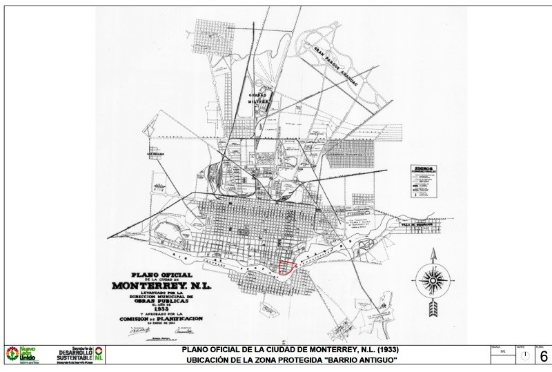
monterrey-1933-whole-city

The city of Monterrey in 1933

Between 1933 and 1947, the city continues to expand, with many areas being infilled with residences:
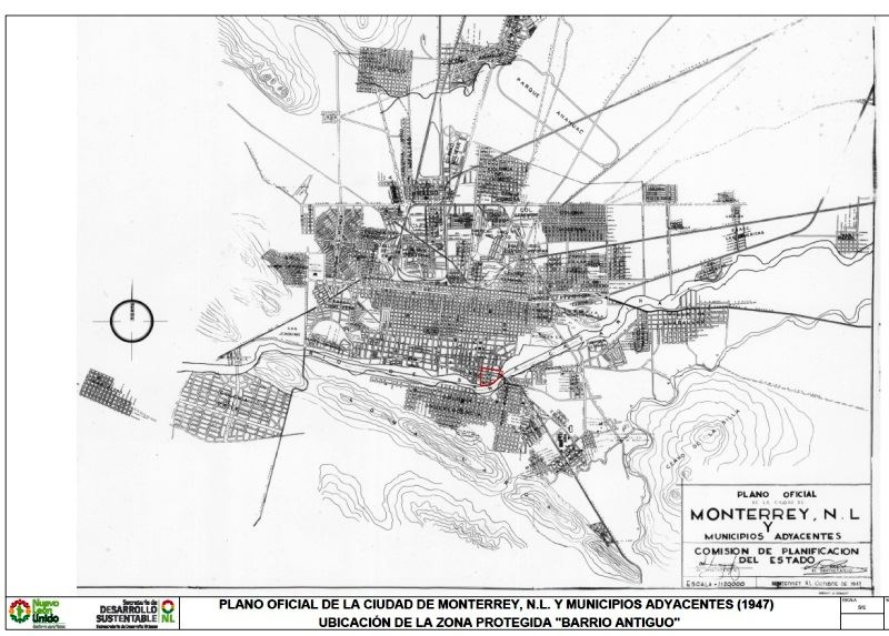
monterrey-1947

The city of Monterrey in 1947

The city experienced another surge of industrialization and immigration in the 1950s and 1960s. Industrial development continued after 1970 when the national government implemented policies to shift development away from Mexico City. Monterrey became a major producer of steel, metal fabrication, cement, beverages, petrochemicals, food, telecommunications, auto parts, glass, and house furnishings. It also developed into a major financial center and one of the wealthiest and most progressive cities in the country.

Low income housing became a serious problem after the 1960s as the inner city tenements became extremely crowded. The government was not sympathetic to irregular housing schemes, so low income groups established numerous illegal squatter settlements on vacant land near the industrial zone. Government made a few efforts to remove these, but most survived and eventually became regularized.

The high status sector expanded south-west into San Pedro Garza García, which became one of the wealthiest municipalities in Mexico. The high overall income and wages in the city meant that many workers could afford home ownership and private automobiles. As a result, many gated communities (large and small) and suburban shopping malls were built around the urban periphery. The urban area became relatively fragmented with many low income residential zones located near high income areas.

Source of the maps used in this post:

Other posts about the urban geography of Mexico’s cities:
The urban regeneration of Barrio Antiguo in Monterrey

 Updates to Geo-Mexico  Comments Off on The urban regeneration of Barrio Antiguo in Monterrey
Oct 142013
 

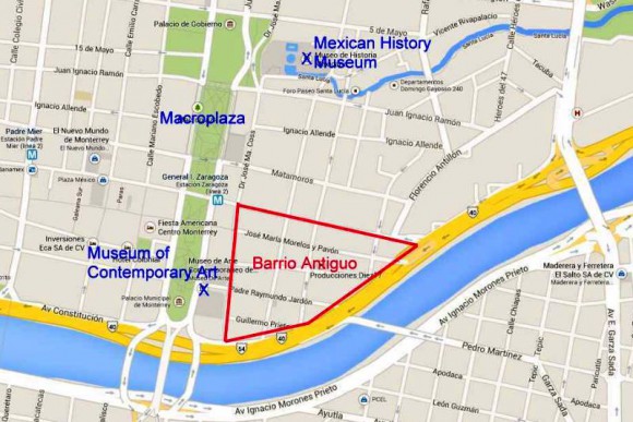
The city of Monterrey in Nuevo León has begun an urban regeneration scheme to rejuvenate one of its oldest sections, Barrio Antiguo (see map below).

Location of Barrio Antiguo, Monterrey.

Location of Barrio Antiguo, Monterrey. (Base: Google maps)

Barrio Antiguo is the area to the east of the Macroplaza. It is bounded to the south and east by Avenida Constitución, to the west by Calle Doctor Coss and to the north by Calle Padre Mier.

Earlier this year, city authorities, with assistance from the Nuevo León state government, published an online Catalog of Buildings of Historic and Artistic Importance in Barro Antiguo, which will form a basis for future planning decisions about any changes of land use in the area. [To view the entire catalog, scroll down in the center frame on that page.]

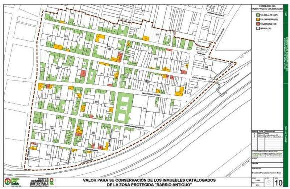
The Catalog includes a series of historic maps, from 1765, 1791, 1846, 1865, 1922, 1933 and 1947 respectively, as well as modern maps showing the location of all individual properties in Barrio Antiguo, color-coded to show their importance in terms of conservation and restoration efforts.

Conservation value of buildings in Barrio Antiguo, Monterrey

Conservation value of buildings in Barrio Antiguo, Monterrey (green=high, yellow=medium; red=low; white=no value)

The first phase of the urban regeneration scheme (called “Nuevo Barrio Antiguo”) includes a “paint job” in which all the buildings in the Barrio’s 16 blocks (manzanas) will be repainted in pastel colors. Owners can choose from a palette of pastel colors that has been predetermined as being in keeping with the historic and architectural characteristics of the area. Click here for the approved colors, complete with color swatches, and the matching paint names for different manufacturers.

During the first phase, new street signs will be installed, as well as tiles highlighting associations to famous people who lived or worked in the Barrio Antiguo. A second phase will restore sidewalks, add new street lighting, and involve public consultation about creating cultural and recreational space. Some streets would also be pedestrianized. Planners would seek to ensure that a wide mix of land uses is retained in the area, including residential, and that the area becomes attractive to visitors and tourists. The accessibility of Barrio Antiguo would be boosted if (or when) Line 3 of the city’s Metro system is built, since its proposed route would start near Barrio Antiguo and run 7.5 kilometers to the Metropolitan Hospital.

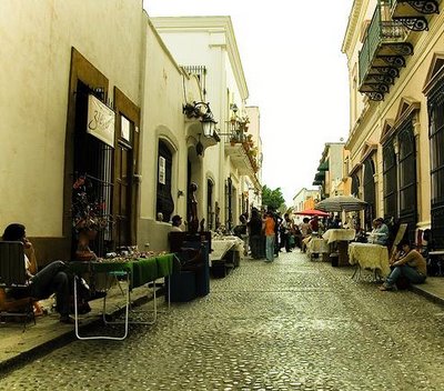
Barrio Antiguo, Monterrey

Barrio Antiguo, Monterrey

The Catalog identifies 193 buildings from the 18th, 19th and 20th centuries as being worth preserving, and the catalog entries for individual buildings provide a cross-reference to other listings of historic buildings such as those previously compiled by the National Anthropology and History Institute (INAH) and state-level agencies. The oldest building in Barrio Antiguo apparently dates back to 1765, while La Casa del Campesino incorporates parts of an even earlier building (from 1728). The listed buildings cover a range of architectural styles ranging from what is described as “vernacular north-eastern architecture” to neoclassic and art deco.

As Monterrey has grown, the condition of Barrio Antiguo’s building stock has deteriorated significantly. During the 1990s and 2000s, many buildings were turned into twilight zone businesses such as cafes, bars and nightclubs. La Casa del Campesino has been repeatedly re-purposed over the years, serving at different times as a government building, charity, hospital, and even a short-term emergency shelter following severe floods in 1909.

Not everyone is happy about the regeneration plans. Critics are vocal about the potential interruption to commerce and small businesses, and fear that it will attract land speculators.

In addition, this is not the first time that plans have been hatched to regenerate Barrio Antiguo. Grandiose plans have been announced on several previous occasions but have never come to fruition.

Housing policy in Monterrey

This 2008 paper by Dr. Peter Ward provides an excellent introduction to housing policy in Monterrey Metropolitan Area:

Related posts:

Have big cities in Mexico succeeded in meeting people’s needs?

 Books and resources, Other  Comments Off on Have big cities in Mexico succeeded in meeting people’s needs?
Sep 262013
 

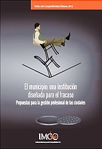
In 2012, the Mexican Institute for Competitiveness (Instituto Mexicano para la Competitividad AC, IMCO) published an analysis of the competitiveness of 77 of the largest cities in Mexico, looking to see which of them offered balanced growth alongside a good quality of life for their inhabitants.

portada_indiceThe elements of competitiveness considered included the degree of compactness (more compact cities are more efficient and sustainable), public finances, transport, security, water management and waste management. The IMCO methodology is explained in detail in the report Índice de Competitividad Urbana 2012. In short, IMCO evaluated each of the 364 municipalities involved in the 77 cities, using 60 indicators grouped into 10 mutually-exclusive sub-indexes.

Between them, these 77 cities house 63% of Mexico’s total population and account for 80% of Mexico’s GDP. 55% of Mexico’s population live in cities managed by two or more municipalities. IMCO found that public transport was adequately coordinated in only 13% of cities with two or more municipalities, while urban planning was coordinated in 35% of the multi-municipality cities.

The IMCO report concludes than most Mexican cities do NOT offer balanced growth and a decent quality of life for residents. Individual cities can be compared using this IMCO site.

The only city offering a “High” level of competitiveness was Monterrey.

Several cities offered an “Adequate” level: Mexico City, San Luis Potosí, Querétaro, Ciudad del Carmen, Saltillo, Tampico, Colima, Guadalajara, Mexicali, Monclova and Campeche.

At the other end of the spectrum, the competitiveness of several cities in Mexico was categorized as “Low”: La Piedad, Cd. Cárdenas, Rioverde, Matamoros, Tehuantepec, Tijuana, San Francisco del Rincón, Cd. Juárez, Ensenada and Poza Rica.

The lowest levels of competitiveness (“Very Low”) among the 77 cities studied were found in two cities in the state of Guerrero: Chilpancingo and Acapulco.

The report used data from 2010, so some aspects of these cities will have changed since that date. For example, the sharply increased murder rate in Monterrey since 2010 will have reduced its lead over other cities.

Certain cities have faced severe challenges of rapid growth. In recent decades, the cities that have grown most rapidly have not been the very large cities like Monterrey, but mid-sized cities. One example of a mid-sized city that has grown rapidly is Ciudad Juárez, whose area grew 497% from 1980 to 2009, while its population rose 70%. This rapid growth may have contributed to the high levels of crime experienced in the city.

IMCO concludes that Mexican cities are showing clear signs of not functioning well: chaotic expansion, heavey traffic, high levels of air pollution, poor supply and/or quality of potable water, high crime levels. These have caused cities to lose competitiveness and the capacity to attract human talent from outside, whether for business, sports or research.

The single obstacles to increased competitiveness are the lack of professional urban management, and the fact that many cities involve two or more municipalities. The laws governing municipal elections inevitably mean that administrations are short-term, with a high level of staff turnover. The impossibility of re-election means that many urban projects are overly superficial and they lack continuity from one administration to the next.

IMCO suggests that a new administrative position be created: the city manager (administrador urbano). The city manager would be a professional manager, and would ensure that the city has adequate coordination for all urban public services, even where more than one municipality is involved. This would free the municipal politicians from having to tackle the day-to-day management issues of the city and allow them more time to engage productively with the citizenry. However, for this to happen, a major institutional innovation is required.

Related posts:

Aug 052013
 

A recent study published by the Clean Air Institute analyzed air pollution in 22 Latin American cities:

  • Air Quality in Latin America: An Overview (May 2013; pdf file)

Six Mexican cities were included in the study: Mexico City, Guadalajara, Monterrey, Puebla, Ciudad Juárez and León. However, only limited data were available for Puebla, Cd. Juárez and León. One of the main conclusions of the study is that Mexico has about the worst urban air pollution in Latin America. It is believed to be responsible for about 15,000 deaths in Mexico each year.

The focus was on the following air pollutants:

  1. Particulate matter is divided into two measures; particles less 2.5 microns in diameter (PM2.5) and those less than 10 microns (PM10). PM2.5 pollution is extremely harmful because it penetrates deep into lungs causing inflammation and worsening heart and lung diseases. This can be fatal.
  2. Ozone is formed in the air when oxides of nitrogen and volatile organic compounds mix with intense sunlight. The very intense sunlight in Mexican cities makes them particularly prone to ozone pollution.
  3. Nitrogen dioxide (NO2) is caused by high temperature combustion of fossil fuels in vehicles, factories and power plants. It can aggravate lung diseases as well as contribute to ozone and fine particle pollution.
  4. Sulfur dioxide (SO2), which also comes from burning fossil fuels, contributes to heart and respiratory disease. Unfortunately, not all of the 22 cities had data on all four pollutants. Consequently comparisons among cities are a bit limited.

According to the study, Mexican cities had some of the worst urban particulate pollution in Latin America, significantly above WHO standards. Of the 16 cities with data, Monterrey had by far the worst PM10 pollution with 85.9 micrograms per cubic meter (ug/m3); considerably worse than the perennially dusty Lima with 62.2 ug/m3. Guadalajara came second with 70.1 ug/m3, Mexico City was 6th with 57.0 ug/m3, and León placed 11th with 39.0 ug/m3, even worse than Sao Paulo at 36.5 ug/m3. Though not in the study, Mexicali has worse PM10 pollution than Monterrey. Also Monterrey’s PM10 levels are much better than many major world cities including Cairo, Delhi, Kolkata, Beijing, Chengdu, Bangalore, Shanghai, Dacca, Jakarta, and Karachi.

Mexico City air quality in 1980 (Photo: Tony Burton)

Mexico City air quality in 1980 (Photo: Tony Burton)

Mexico did a bit better with respect to the more serious PM2.5. Of the 11 cities with data, Bogota was worst with 35.1 ug/m3 followed by Lima at 31.5ug/m3 and San Salvador and Montevideo at 28.0 ug/m3. The two Mexican cities with data, Mexico City (26.2 ug/m3) and Monterrey (25.9 ug/m3) were 6th and 8th.

Mexican cities also have some of the highest levels of ozone pollution. Of the ten cities with data, five of the six worst were Mexican cities. Guadalajara had the highest ozone pollution with 69.3 25.9 ug/m3 followed closely by León 68.9 at ug/m3. Mexico City was 4th (59.4 ug/m3); Monterrey was 5th (55.2 ug/m3); and Cd. Juárez came 6th (46.3 ug/m3), just ahead of Quito (44.1). Much better ozone levels were recorded by Sao Paulo (36.0 ug/m3), Santiago (28.8 ug/m3) and Bogota (21.1 ug/m3).

Cities in Mexico also had high levels of nitrogen dioxide. The highest levels were in Montevideo (70.0 ug/m3), but Guadalajara (57.2ug/m3), Mexico City (54.2 ug/m3) and León (45.5 ug/m3) placed 2nd, 3rd and 4th worst among the 14 cities with data. Monterrey was much better with the third lowest nitrogen oxide level (29.0 ug/m3), trailing only Lima (12.8 ug/m3) and Quito (23.3 ug/m3).

Mexican cities were also among the worst in terms of sulfur dioxide pollution. Of the 13 cities with data, León had by far the highest level with (23.4 ug/m3), followed by Medellin (16.0 ug/m3). Mexico City was 3rd worst (15.3 ug/m3); Monterrey was 4th (13.1 ug/m3); and Guadalajara was 6th (8.6 ug/m3).

In summary, the study indicates that Mexico has about the worst urban air pollution in Latin America. Fortunately, Mexico City, which used to be considered one of the most polluted cities in the world, has significantly improved its air quality in the last few decades. (see Rhoda and Burton, Geo-Mexico: The geography and dynamics of modern Mexico, p 177)

On the other hand, other major cities in Mexico have not had the same experience. The data in this study appear to suggest that among Mexico’s three biggest cities, Guadalajara has the worst air pollution followed by Mexico City and then Monterrey. (This study found insufficient data for comparisons with Puebla, Cd. Juárez and León.)

Other posts on urban air pollution:

Suburbia in Mexico: Alejandro Cartagena’s images of Monterrey

 Books and resources  Comments Off on Suburbia in Mexico: Alejandro Cartagena’s images of Monterrey
Mar 242012
 

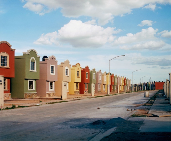
What do Mexican suburbs look like? What is their function? As the country’s towns and cities continue to expand, new suburbs appear on their outer edge. Some are gated communities, generally aimed at high income families; these suburbs sometimes include private schools and sports clubs. Other suburbs offer smaller homes aimed at low-income families.

Photographer Alejandro Cartagena lives in the Monterrey Metropolitan Area, which includes nine different municipalities in the state of Nuevo León: Monterrey, Guadalupe, San Nicolás, San Pedro, Santa Catarina, Escobedo, Apodaca, García and Juárez.

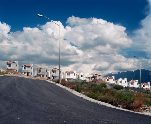
Cartagena spent years exploring the edge of the city to document the manifestations of “suburbia mexicana” through photographs. The suburbs he depicts are mainly low-income suburbs, some still being constructed. Cartagena recognized that change was happening at a very rapid pace, and often by developers with more lust for profit than desire to improve the local community. Since 2001, more than 300,000 new homes have been built in the Monterrey Metropolitan Area. Many suburbs were badly planned, as some of Cartagena’s photos clearly reveal. Considerations of roads, parks and public transport are often ignored in the decision-making of these developers.

Copyright: Alejandro Cartagena; all rights reserved. Image from "suburbia mexicana"; reproduced by kind permission.

Copyright: Alejandro Cartagena. Image from "suburbia mexicana". Reproduced by kind permission.

“Suburbia mexicana” includes five series of images, each briefly described below. For fuller descriptions of Cartagena’s ideas, please use the links from the title of each series to visit his relevant section of his website:

Fragmented Cities explores what the homes look like, as if being photographed for a real estate brochure.

Lost Rivers looks at the “environmental problems that stem from excessive urban and suburban development such as dried up and polluted rivers and streams.”

The Other Distance attempts to “connect the wealthy with the new-middle and low class urbanization models” by looking at San Pedro Garza García, which is one of the richest municipalities in Mexico, and easily the wealthiest part of the Monterrey Metro Area. Quoting geographer David Harvey on the “inter-connectivity between urbanization and capital accumulation”, Cartagena explores the economic contrasts that have created two distinct spaces (based on wealth), one that lacks specific “social cohesion space” such as parks, not designed to take into account “infrastructure, hospitals or education centers”, and one occupied by the wealthy sectors of society where such things are considered their “right”. Cartagena recognizes that both these spaces have an interdependent symbiotic relationship.

Copyright: Alejandro Cartagena; all rights reserved. Image from "suburbia mexicana"; reproduced by kind permission.

Copyright: Alejandro Cartagena. Image from "suburbia mexicana". Reproduced by kind permission.

Urban Holes depicts abandoned spaces in downtown Monterrey, so “highly overpriced by market speculation” that “investors look to un-urbanized land to create new developments that are lacking all kinds of infrastructure”.

The People of Suburbia, the final section, is based on a return to some of the areas photographed previously, including the municipality of Juárez, where urbanization has led to the population tripling since 2002. It is a “visual study of the unending capitalist endeavor of urban growth”.

In Cartagena’s own words, the photos of “suburbia mexicana” “depict a global issue from a local perspective” and one his intentions is “to point out the struggle our contemporary world faces between the ideals of capitalism and the striving and desire for fairer and more equal cities in which to live.” As such, this splendid collection of photographs certainly deserves the widest possible audience.

If you like Alejandro Cartagena’s work, you may like to know that he has published a book of “suburbia mexicana”, available via his website.

For more details about the Monterrey Metropolitan Area, see this 2008 paper by Dr. Peter Ward: