Jul 092015
 

The Jalisco state government has released an informative 5-minute video highlighting some of the reasons why Jalisco is one of the best locations in Mexico for farming, business and tourism.

The video can be viewed on Facebook: Esto es Jalisco. This is Jalisco.

Following opening shots showing some of the diverse landscapes of the state, including the Piedrotas at Tapalpa, the majestic Volcán de Colima (whose summit is actually in Jalisco, not Colima) and the Horseshoe Falls near the Dr. Atl park on the northern edge of Guadalajara, the video’s subtitles (in English) turn to techno0logy and innovation. Jalisco is the first state in Mexico to have a Ministry of Innovation, Science and Technology. The state capitol Guadalajara is the center for MIND (Mexican Innovation and Design Center) and was chosen by MIT for the establishment of a Creative Digital City.

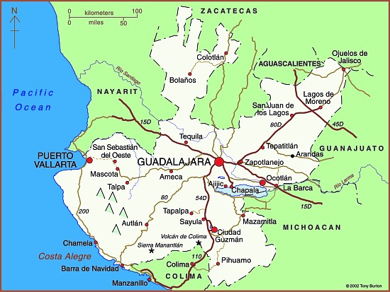
Map of Jalisco state

Map of Jalisco. Copyright 2010 Tony Burton. All rights reserved.

The city also has major cultural and sporting attractions, from libraries to golf courses to hosting international events in the Expo Guadalajara to concerts and its own international film festival. It also hosts the world’s second largest book fair (after Hamburg). Its industrial activity ranges from agro-processing (including tequila) to pharmaceuticals, information technology, automotive and aerospace firms to renewable energy enterprises.

Foreign investment in Jalisco has risen by an average of 17% a year for the past decade, with foreign firms finding the state’s geographic position advantageous for serving central Mexico and with excellent trade links to Asia and the U.S.

The state’s leading coastal resort is Puerto Vallarta, but tourism is also important in the state’s interior. Jalisco has five places with Magic Town status: Lagos de Moreno, San  Sebastian del Oeste, Tapalpa, Mazamitla and Tequila.

Jalisco currently accounts for 6.6% of national GDP and the state government clearly expects this contribution to grow in coming years. This professionally-produced video is an excellent visual introduction to one of Mexico’s most important states.

Related posts:

The 2014 Tecate SCORE Baja 1000 off-road race

 Other  Comments Off on The 2014 Tecate SCORE Baja 1000 off-road race
Nov 082014
 

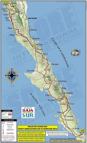
Entrants in the 2014 Tecate SCORE Baja 1000 off-road race have to complete a grueling off-road route that runs almost the entire length of the Baja California Peninsula. The race starts in Ensenada, Baja California, and ends in La Paz, Baja California Sur (see map). The approximate point-to-point distance is 1820 kilometers (1,130 miles). The 47th Tecate SCORE Baja 1000 race is being held this year from 12-16 November.

Route of Score 1000 Baja off-road race

Route of Score 1000 Baja off-road race

The race gives us a good excuse to offer this brief introduction to the geography of the very long, narrow Baja California Peninsula, which stretches for about 1150 km (700 mi).

In the north, it is composed of mostly granite, while the south is mostly marine sediments and lava.

To the east of the peninsula, the Sea of Cortés (Gulf of California) occupies a trough resulting from a series of faults which are linked to the famous San Andreas Fault system in California. Prior to the opening up of the Gulf of California, the peninsula was attached to the mainland. There are several volcanic islands in the Gulf.

The backbone of the peninsula is a crystalline mountain system with many peaks exceeding 1500 m (5000 ft) and some reaching as high as 3000 m (10,000 ft). The mountains have longer, gentler western slopes and steeper more rugged eastern slopes. Thus, as viewed from the Gulf of California, the Baja Mountains and the Western Sierra Madre look steep, foreboding and very rugged, while from the other side they look more subdued.

Climatically, almost the entire peninsula is extremely arid and forms the western part of the Sonoran Desert. It receives only limited and infrequent rainfall. However, the southern part of the peninsula does experience the occasional hurricane (such as Hurricane Odile earlier this year) which brings powerful winds and torrential downpours.

Population is distributed very unevenly on the Baja California Peninsula. The heaviest concentration of people is found in the extreme north, close to the U.S. border, a region which includes the cities of Tijuana, Mexicali and Ensenada. There are very low densities of population in most of the middle section of the peninsula, where the most important settlements include Guerrero Negro, Santa Rosalía,Ciudad Insurgentes and Ciudad Constitución.

The southern portion of the peninsula has attracted more settlement and this area, which includes San José del Cabo, Cabo San Lucas, La Paz and Todos Santos, is one of Mexico’s premier tourism regions.

Want to read more?

The regional geography of music in Mexico

 Other  Comments Off on The regional geography of music in Mexico
Nov 062014
 

Here are brief descriptions of some of the most commonly heard forms of regional music within Mexico. What you hear depends on where you travel!

Mariachi

For many decades, mariachi has been widely considered to be the quintessential Mexican folk-music genre, and has become an important symbol of Mexican music and culture.

A mariachi band is a term used to describe an ensemble band of five or more musicians that wear the traditional costume of a charro or Mexican cowboy. The costume consists of a waist-length jacket, tightly fitted pants and boots and a large sombrero. The jacket, pants and sombrero are elaborately decorated with colorful metal ornaments and intricate embroidered designs.

The unique sound of mariachi music is created by combining trumpets, violins, and guitars with two traditional Mexican instruments, the vihuela and the guitarrón. The music is characterized by loud, hard driving rhythms, spirited melodies and humorous lyrics. Shouts and cries (gritos) are periodically given while a song is being sung, giving the music an additional lively character.

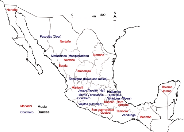
Music and dance in Mexico.

Music and dance in Mexico. Fig 13.3 of Geo-Mexico, the geography and dynamics of modern Mexico. All rights reserved.

Ranchera

Another very popular Mexican music form is the ranchera (ranch song), which originated during the time of the Mexican Revolution. It is basically cowboy music, and the singers dress in the traditional style of the Mexican horseman with tight breeches, jacket, boots, gun holsters and a large sombrero.

The lyrics of ranchera songs typically deal with rural life, unrequited love, or about the struggles of ordinary people living in the country. The songs are sometimes joyous and sometimes nostalgic or tragic, and are often sung in a very dramatic and passionate manner, with the singer crying out “Ay, ay, ay, ay, ay!” at various points.

Norteña

Another popular music genre, particularly in northern Mexico, is the norteña. This form of music has its origins in the ballads that were traditionally sung by people living along the USA-Mexico border. This music style is typically a hybrid of many other musical forms, including the waltz, polka, and country music.

Norteña is high energy music, driven by the accordion and the booming bass sound of the bajo sexto, a large 12-string guitar. The lyrics of norteña songs typically deal with stories of life along the border, illegal immigrants, outlaws and desperados, drug dealers (narcotraficantes), corrupt public officials, rejected lovers, etc.

Many norteña bands are quite large, with a full horn section and strings. The genre’s most famous group, Los Tigres del Norte has cultivated a large number of fans both in Mexico and in the USA.

Banda

Banda (Band) refers to the form of music played by large brass ensembles that first appeared in the northern Mexican state of Sinaloa several decades ago. A typical banda ensemble features trumpets, trombones, tubas and percussion instruments, and may include keyboards. String instruments are used sparingly, if at all. Banda sounds somewhat similar to American Big Band music, but with a distinctive Hispanic twist.

Related posts:

Mexico’s seven climate regions

 Excerpts from Geo-Mexico  Comments Off on Mexico’s seven climate regions
Aug 152013
 

Climatologists have developed several scientific systems to classify climates. The system developed by Wladimir Köppen in the early 20th century is one of the earliest and best known. The Köppen climate classification system assumes that climate is best reflected in native vegetation and can be accurately classified using seasonal variations in temperatures and precipitation. Mexican climatologists, including Enriqueta García, have proposed minor modifications to the Köppen system to make it more appropriate for Mexico. The following paragraphs reflect García’s revised Köppen system.

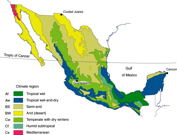
Given that Mexico has many mountains with rapid changes in elevation, temperature and rainfall, applying the Köppen system, even as modified by García, to Mexico can become extremely complicated. A relatively small area of Mexico may include several Köppen climate categories. Aggregating these areas provides a less complicated, more understandable, picture of Mexico’s climates (see map). In this scheme, Mexico has seven main climate regions, as shown on the map:

Major climate regions in Mexico. (Fig 4-5 of Geo-Mexico, the geography and dynamics of modern Mexico). All rights reserved.

Major climate regions in Mexico. (Fig 4-5 of Geo-Mexico, the geography and dynamics of modern Mexico). All rights reserved.

Two tropical climates

Mexico has two tropical climates which have average temperatures of over 18°C (64°F) for all twelve months of the year.

The first, tropical wet (Af in the Köppen system, see map), has at least 60 mm (2.4 in) of rain in every month of the year. This is the climate of the Amazon and Indonesian rainforests. In Mexico this is the climate of the Gulf Coast Plain in southern Veracruz and Tabasco (classic tierra caliente areas). It also occurs in the Oaxaca and Chiapas highlands. The rains fall all year, varying from about 120–150 mm (4–5 in) in April to 380 mm (15 in) in September.

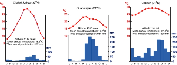
The tropical wet-and-dry (Aw) category (see the climate graph for Cancún) has a pronounced dry season. The dry winter months typically get less than 40 mm (1 in) of rain, compared to over 150 mm (6 in) in each of the summer months. Parts of West Africa, Brazil and India have a similar climate. Much of coastal Mexico, stretching from Nayarit along the Pacific coast all the way to Guatemala, is in this category. It also covers many inland areas along the Pacific coast. Central and northern Veracruz and most of the Yucatán Peninsula also have this tropical climate with summer rains.

Climate graphs for three cities. (Fig 4.6 of Geo-Mexico,)

Climate graphs for three cities. (Fig 4.6 of Geo-Mexico, the geography and dynamics of modern Mexico) All rights reserved.

Two dry climates

Areas with an arid (desert) climate (BW) usually receive less than 250 mm (10 in) of rain a year (see climate graph for Ciudad Juárez). This is the climate of the Sahara Desert and Central Australia. In Mexico dry desert areas include most of Baja California, western Sonora, and the northern section of the Central Plateau. These areas can experience frost and freezing during the winter.

Areas with the second type of arid climate, semiarid (dry steppe) (BS), receive 250–750 mm (10–30 in) of rain a year. This is the climate of the African savanna lands and much of central Asia. In Mexico, this climate region includes most of the Central Plateau as well as western sections of the Western Sierra Madre, northern Yucatán and scattered inland areas as far south as Oaxaca. The rains in this region fall mostly in the summer, and localized heavy thunderstorms are quite common. The southern parts of this climatic region are warmer than the northern parts.

Three temperate zones

Temperate climates typically have average temperatures above 10°C (50°F) in their warmest months, and a coldest month average between 3°C and 18°C (27–64°F). Moisture characteristics distinguish between the three temperate climates.

The temperate with dry winters climate (Cw) is characterized by mild temperatures, low humidity, and summer rainfall ranging from about 600 to 1200 mm (25–45 in) per year (see climate graph for Guadalajara). This is classic tierra templada country. The low nighttime temperatures in winter are typically around 5°C (41°F). Of course, higher elevations have lower temperatures with occasional frost. The highest temperatures usually reach about 35°C (95°F), though temperatures may reach as high as 40°C (104°F). This climate is similar to that of the Kenyan Highlands. In Mexico, this climate includes parts of Nuevo León and Tamaulipas, most of the Western Sierra Madre and many mountainous areas in western, central and southern Mexico. Most of the Volcanic Axis is in this temperate with dry winters zone. Here, the major control as far as temperatures are concerned is altitude, which directly affects precise rainfall amounts and seasonality, resulting in a mosaic of microclimates and natural vegetation regions.

Compared with the temperate with dry winters climate, the humid subtropical (Cf) zone gets more rainfall, is more humid and gets rain throughout the year. The only areas of Mexico with this climate are the eastern slopes of the Eastern Sierra Madre and some parts of the southern mountain systems.

The Mediterranean climate (Cs) is the mild climate associated with Europe’s Mediterranean coast as well as the California coast. The area around Tijuana is the only part of Mexico with this type of climate. This area is relatively arid and gets less than 400 mm (15 in) of rain a year; it is unique in Mexico, being the only place that is dry in summer and gets rain only in winter.

Related posts

Jul 242013
 

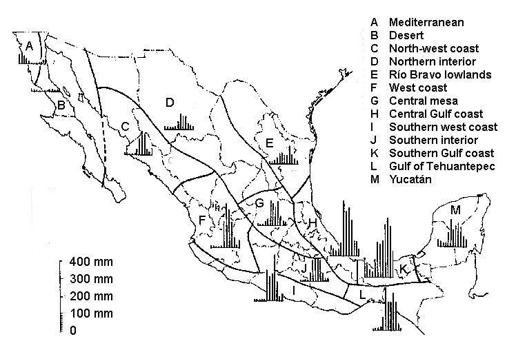
The map below shows a regional division of Mexico by precipitation regime (the amount and seasonal distribution of precipitation). The small graph for each region shows the typical average precipitation amounts for each month of the year. (For example, region A has most precipitation in the first three or four months of the year, and very little after that). The map comes from Ernesto Jáuregai’s 1970 article about wind and water erosion in Mexico (full reference is given below).

Precipitation regimes in Mexico (Fig 2 of Jáuregai 1970)

Precipitation regimes in Mexico (Fig 2 of Jáuregai 1970)

It is clear from the map that the distribution of precipitation across Mexico is very uneven. In general the north and central plateaus are dry while the southeast receives by far the most rain. Parts of Tabasco, Northern Chiapas and Veracruz get over 4000 mm (160 in) of rain a year. This is a direct effect of the onshore north-east trade winds, which collect moisture as they cross the Gulf of Mexico and then deposit it as they reach land.

Average annual rainfall figures conceal great differences from one year to the next. In general, the variability of rainfall is indirectly proportional to the long-term average. This means that areas with low totals tend to experience high variability, greatly increasing their drought hazard.

The map also reveals that there is a marked seasonality to precipitation in almost all of Mexico, with a clear division into a wet and a dry season. Most places get almost all their rain between June and October, while January through May are dry months. Because most rainfall is in the summer months, about 71% of rainfall evaporates soon after falling. This figure can be even higher in urban areas. Only about 26% runs off into rivers and lakes, and 3% seeps down to recharge subterranean aquifers.

One apparent anomaly to the pattern shown on the map is that the extreme north-west corner of Baja California (region A) has a Mediterranean climate where summers are dry and most rain falls in winter. Elsewhere in Mexico winter months are relatively dry. Southern and central Mexico have markedly dry winters, receiving less than 5% of their annual precipitation totals in the first three months of the year. The northern half of Mexico and the eastern coastal strip, including the Yucatán peninsula, have slightly more balanced precipitation, receiving between 5 and 18% of annual totals between January and March.

Map reference:

Ernesto Jáuregai. 1970. “La erosión hidráulica y eólica en México y sus efectos en las estructuras hidráulicas y en los núcleos de población.” UNAM: Boletín del Instituto de Geografía, Vol III, pp 39-60.

 Related posts

The important but often overlooked state of Puebla

 Other  Comments Off on The important but often overlooked state of Puebla
Dec 022011
 

The interesting and important state of Puebla is often overlooked because it is overshadowed by nearby Mexico City. In fact the western state border of Puebla is within 35 kilometers of the eastern edge of the Federal District. The state of Puebla also may be overlooked because it is rather small in area, ranking only 21st among Mexico’s 32 states. On the other hand, its 2010 population of nearly 5.8 million ranks it 5th behind only Mexico State, the Mexico City Federal District, Veracruz and Jalisco.
Though small in size, Puebla is very diverse. The topography is rugged and elevations range from under 100 meters in the northeast to volcanoes  rising over 5,000 meters above sea level, both to the east (Orizaba – 5,636m) and west (Popocatepetl – 5,410m and Iztaccihuatl – 5,230m). These extremes in elevation give Puebla a very wide range of climates and ecosystems, from semi-tropical rainforests and grasslands to highland forests and alpine ice packs.

Almost inevitably, given its high population density (168.5 inhabitants/square kilometer), many of these ecosystems have been degraded. Several of the most attractive natural areas are now protected. They include the Izta-Popo Zoquiapán, La Malinche and Pico de Orizaba National Parks as well as the very large Tehuacán-Cuicatlán Biosphere Reserve, which has over 100 different mammal species, 16 of which exist nowhere else on the planet.

Puebla also has significant social and ethnic diversity. There are numerous wealthy people and upscale areas in Puebla City, which has the eighth highest 2005 Human Development Index (HDI) score among major Mexican cities, behind only Mexico City, Chihuahua City, Monterrey, Querétaro City, Cancún, Torreón and Cuernavaca. Most people are surprised it comes out ahead of Guadalajara and Zapopan.

On the other hand, the state as a whole is rather poor. Based on its relatively poor levels of infant mortality, literacy, school enrollment, and income levels, the state ranks 28th of 32 states in terms of 2008 Human Development Index. Puebla is tied with Michoacán and ahead of only Chiapas, Guerrero and Oaxaca[1]. It also ranks 28th in illiteracy which is over 10% (2010); however 96% of the 6 to 11-year-olds now attend school, and illiteracy for those between the ages of 15 and 25 is less than 3%. While 98% of homes now have electricity, over half of Puebla’s workers make less than $115 pesos ($8.20US) a day. Approximately two/thirds of the state’s population live below the Mexican poverty line. The state’s high level of poverty is partially due to its indigenous population of almost one million and the fact that almost 30% of its inhabitants live in rural areas, some of them quite remote.

The city of Puebla is the heart of a Metropolitan Area which extends across state lines to the city of Tlaxcala. Metropolitan Puebla-Tlaxcala is the country’s 4th largest urban area with a population over 3.1 million, but is overshadowed by Mexico City, the eastern edge of which is less than 30 minutes by expressway. In fact, some urban specialists suggest that these two major metropolitan areas may merge in the future. On the other hand, the mighty Popocatepetl and Iztaccihuatl volcanoes, both over 5,000 meters in height, lie directly between the two cities. The high speed expressway skirts around the north side of the volcanoes.

The city of Puebla has long had strategic significance. The city was initially established during the colonial period owing to its strategic location between Mexico City and Veracruz, the dominant port for shipments to and from Spain. Puebla was the country’s second largest city for more than three centuries up until the mid 19th century. The Mexico City-Puebla railway was completed in 1869, but the main line to Veracruz bypassed the city, which diminished its comparative advantage, and resulted in it dropping to fourth place, overtaken by Guadalajara and Monterrey.

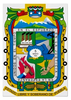
The state’s historical importance is evidenced by numerous important military confrontations, including the massacre of Cholula (1519), Santa Ana’s siege of Puebla City (1845), American General Winfield Scott’s occupation (1845-48), the “Cinco de Mayo” battle of Puebla against the French (1862), the French victory in the Second Battle of Puebla (1863), and occupation by the Zapatistas during the Mexican Revolution. The state is the birthplace of four Mexican Presidents: Ignacio Comonfort (1855–1858), Juan N. Méndez (1876–1877), Manuel Ávila Camacho (1940–1946) and Gustavo Díaz Ordaz (1964–1970).

Despite the state’s relative poverty, industrial development has been significant and Puebla has become one of Mexico’s most industrialized states. Since colonial times Puebla has been an important center for the textile and ceramic industries. Much of Mexico’s famous talavera pottery is made in Puebla. Talavera came to Puebla from Talavera, Spain, which in turn had acquired it from Arab traders who originally brought it from China.

Since the mid 20th century Puebla has become a very important modern industrial area. The most important manufacturing activities are metals, chemicals, electronics, textiles and particularly motor vehicles. The Volkswagen plant in Puebla is one of the largest outside Germany. In July 2003 it produced the very last of the over 21 million old “Beetles” built by VW. The plant now produces New Beetles, Jettas and Boras that are exported worldwide. The motor vehicle assembly industry is supported by scores of automobile parts factories in the state.

Related articles:
The Transnational Metropolitan Areas of Mexico-USA

 Other  Comments Off on The Transnational Metropolitan Areas of Mexico-USA
Aug 092011
 

Mexico shares a 3,169 km (1,969 miles) border with the USA. This is one of the most heavily guarded and frequently patrolled  land borders in the world, and a rare example of a land border that separates two countries with very different levels of economic development. These differences in development have, of course, prompted many Mexicans to migrate to the USA, either as seasonal or permanent migrants, and whether “legal” or undocumented.

Some regional geographers have even proposed that a regional division of North America should include a distinctive “border region”,  an international region straddling the boundary and including all border crossings and many notable cities. This region experienced rapid economic growth following the signing of NAFTA, when many companies moved to northern Mexico, setting up maquiladora manufacturing plants. The border area has long been a major focus of drugs-smuggling, with border transport of illegal narcotics getting ever more inventive. In recent years, sadly, this same area has become the scene of some of the worst drugs-related violence in the world.

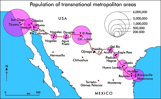
Population of Mexico-USA Transnational Metropolitan Areas.

Population of Mexico-USA Transnational Metropolitan Areas. Credit: Tony Burton; all rights reserved

The map shows the 2010 population of the major transnational metropolitan areas of Mexico-USA. The diameter of each circle represents the combined population of the twin cities that have grown up either side of the border. The pattern closely reflects the volumes of overland transport links (road and rail) between the two countries, as well as of commuters who live one side of the border, but work on the other side and cross daily.

The easternmost part of the boundary between Mexico and the USA follows the Río Bravo (Grande). Inevitably, there have been disputes when the river changed its course. Part of the western boundary follows the course of the Colorado River, from which so much water is taken that it now rarely flows into its delta region in Baja California. All the varied boundary and water-rights treaties and agreements between Mexico and the USA are decided via the International Boundary and Water Commission.

Related posts: