“How big is Lake Chapala?”
There is no single answer to this question. It all depends on the reference point in time.
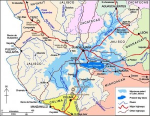
Some geologists suggest that 40,000 years ago, the Lake’s surface area was seven times its current size and its volume about 200 times greater. At that time, the Lake towered almost 700 feet above what is now Guadalajara and stretched nearly to Aguascalientes (see map). The decline of this massive ancient lake resulted from sedimentation, tectonic faulting and the cutting of a fantastic drainage gorge by the Rio Santiago (see Jack Leyden’s “The geology and geography of Lake Chapala and western Mexico”, on MexConnect.com)
In recent history, the size of the Lake has continued to change dramatically. In the 19th century, the Lake stretched almost 20 kilometers farther east. Construction of an 80 kilometer dike and drainage system in 1908 attempted to capture a large portion of the lake for agricultural use. Through a series of successive floods, partially attributed to the Poncitlán Dam on the Rio Santiago, the lake recaptured the land. However, the dikes were re-constructed and the land eventually converted to permanent farmland, only occasionally disrupted by flooding. Environmentalists argue that this has destroyed an important ecological role of this once important marshland.
The size of Lake Chapala has fluctuated significantly in recent decades; from extreme lows in 1954-56, 1992 and 2003 to highs in the 1960-70s and 2005-06. These dramatic low to high changes can increase the Lake level by 8 meters, its volume by a whopping 800% and its surface area by 100%. Fortunately, the Lake is at a relatively high level as we approach the 2010 rainy season.
Obviously, answering the question, “How big is Lake Chapala?” is very time sensitive. In November 2009, Lake Chapala was about 75 by 25 kilometers with a surface area of 1150 square kilometers and a volume of 5.5 billion cubic meters (bcm).
Lake Chapala is sometimes called the largest lake in Mexico, but even this can be questioned. It is the largest in terms of surface area. But with its shallow depth it is not the largest in terms of volume. The amount of water it holds, even when full to maximum capacity, is only 8.1 bcm. It trails three reservoirs behind hydroelectric dams: La Angostura (10.7 bcm), Malpaso (9.6 bcm) and Infiernillo (9.3 bcm). But we must remember that the volume of all Mexico’s lakes and reservoirs varies enormously from season to season and year to year.
What about the future? All lakes are destined to disappear because they all eventually fill completely with sediment. In the not too distant geologic future, Lake Chapala will be gone. Speaking of the future, geologic fault systems aligned with Lake Chapala, working with nearby fault systems, will eventually create a large Pacific island from a big chunk of western Mexico containing Puerto Vallarta and Manzanillo.
These topics are discussed in greater detail in previous Geo-Mexico.com posts:
- “How Lake Chapala, Mexico’s largest lake, was formed” and “The eastern end of Mexico’s largest lake, Lake Chapala, is amputated“,
- in Richard Rhoda and Tony Burton’s Geo-Mexico: the geography and dynamics of modern Mexico (Sombrero Books, 2010)
- in Tony Burton’s Lake Chapala Through the Ages, an anthology of travellers’ tales (Sombrero Books, 2008).

Sorry, the comment form is closed at this time.