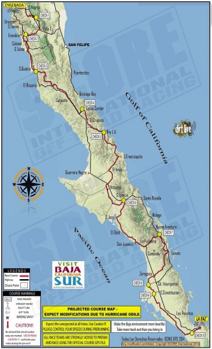
Entrants in the 2014 Tecate SCORE Baja 1000 off-road race have to complete a grueling off-road route that runs almost the entire length of the Baja California Peninsula. The race starts in Ensenada, Baja California, and ends in La Paz, Baja California Sur (see map). The approximate point-to-point distance is 1820 kilometers (1,130 miles). The 47th Tecate SCORE Baja 1000 race is being held this year from 12-16 November.
The race gives us a good excuse to offer this brief introduction to the geography of the very long, narrow Baja California Peninsula, which stretches for about 1150 km (700 mi).
In the north, it is composed of mostly granite, while the south is mostly marine sediments and lava.
To the east of the peninsula, the Sea of Cortés (Gulf of California) occupies a trough resulting from a series of faults which are linked to the famous San Andreas Fault system in California. Prior to the opening up of the Gulf of California, the peninsula was attached to the mainland. There are several volcanic islands in the Gulf.
The backbone of the peninsula is a crystalline mountain system with many peaks exceeding 1500 m (5000 ft) and some reaching as high as 3000 m (10,000 ft). The mountains have longer, gentler western slopes and steeper more rugged eastern slopes. Thus, as viewed from the Gulf of California, the Baja Mountains and the Western Sierra Madre look steep, foreboding and very rugged, while from the other side they look more subdued.
Climatically, almost the entire peninsula is extremely arid and forms the western part of the Sonoran Desert. It receives only limited and infrequent rainfall. However, the southern part of the peninsula does experience the occasional hurricane (such as Hurricane Odile earlier this year) which brings powerful winds and torrential downpours.
Population is distributed very unevenly on the Baja California Peninsula. The heaviest concentration of people is found in the extreme north, close to the U.S. border, a region which includes the cities of Tijuana, Mexicali and Ensenada. There are very low densities of population in most of the middle section of the peninsula, where the most important settlements include Guerrero Negro, Santa Rosalía,Ciudad Insurgentes and Ciudad Constitución.
The southern portion of the peninsula has attracted more settlement and this area, which includes San José del Cabo, Cabo San Lucas, La Paz and Todos Santos, is one of Mexico’s premier tourism regions.
Want to read more?
- How sustainable is organic agriculture on the Baja California Peninsula in Mexico?
- Desalination plants for the Baja California Peninsula
- Map of Baja California Peninsula
- Why is the world’s largest salt-works in Baja California Sur?
- Geography, residence patterns and architecture in Santa Rosalía, Baja California Sur
- The re-opening of the giant El Boleo copper mine in Santa Rosalía, Baja California Sur

Sorry, the comment form is closed at this time.