Jul 042010
 

Northern states have been hard hit by the severe rainstorms associated with the passage of Hurricane Alex on 1 July 2010.

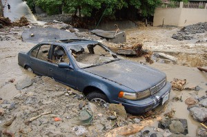
News reports say that at least six people have been killed, one by a mudslide which engulfed her car. The infrastructure in many parts of northern Mexico has been badly damaged.

Damage from Hurricane Alex

Damage from Hurricane Alex. Flickr Creative Commons, Deus ex Camera, 2 July 2010

In Nuevo León, a state of emergency was declared in 21 municipalities, including the Mexico’s second largest city Monterrey. The municipalities affected are Anáhuac, Apodaca, Cadereyta Jiménez, Cerralvo, China, Ciénega de Flores, Doctor Coss, General Escobedo, General Treviño, Guadalupe, Hualahuises, Linares, Los Aldamas, Los Ramones, Melchor Ocampo, Montemorelos, Monterrey, San Nicolás de los Garza, San Pedro Garza García, Santa Catarina and Santiago.

Declaring a state of emergency allows states to access funds held in Mexico’s Fund for Natural Disasters (Fonden).

The storms washed dozens of vehicles into nearby rivers and damaged bridges and protective barriers. Intercity bus service were suspended in various areas until highways blocked by rocks and mud could be cleared.

Despite record rainfalls of up to 820 mm (a year’s worth of rain in just three days!), the storms left 110,000 people in the state without water, and 140,000 without power. Thousands are homeless and have relocated to emergency shelters. The director of the National Water Commission warned that the El Cuchillo dam had reached 124% of its capacity and ordered excess water to be allowed to flow down local rivers.

Damages were also considerable in two neighboring states, Tamaulipas and Coahuila. In Tamaulipas, a state of emergency was declared in 22 municiaplities (Mainero, Villagrán, Hidalgo, Victoria, San Fernando, Méndez, Burgos, Villas Aldama, González, Matamoros, Reynosa, Valle Hermoso, Río Bravo, Soto la Marina, Jiménez, Abasolo, Jiménez, Casas, Mante, Llera, Padilla and Güémez). Damages in Tamaulipas alone were estimated to exceed 100 million dollars.

In Coahuila, one person is still missing. The storm hit 8 municipalities especially hard: Nadadores, where one person was reported missing, Monclova, Saltillo, Ramos Arizpe, Parras, Sacramento, La Madrid, and the Sierra de Arteaga.

While most damage was concentrated in northern states, several municipalities in southern Mexico, including Guerrero and Oaxaca, also reported damage.

Earlier post about the build-up to Hurricane Alex.

Hurricanes and other climatological phenomena are analyzed in chapters 4 and 7 of Geo-Mexico: the geography and dynamics of modern Mexico. Buy your copy today, so you have a handy reference guide available whenever you need it.

Click here for Deus Ex Camera’s photo collection about Hurricane Alex.
How many hurricanes are likely in the 2010 Atlantic hurricane season?

 Mexico's geography in the Press, Updates to Geo-Mexico  Comments Off on How many hurricanes are likely in the 2010 Atlantic hurricane season?
Jul 012010
 

Philip Klotzbach and William Gray, of Colorado State University, have analyzed the atmospheric and oceanic conditions in the Atlantic immediately prior to the 2010 hurricane season. They conclude that this season’s hurricane activity in the Atlantic is likely to be stronger than has been the norm during the past 50 years. They predict that the Atlantic season will see 18 named storms, of which 8 will be classed as tropical storms, 5 as moderate hurricanes (1 or 2 on the Saffir-Simpson scale), and 5 as severe hurricanes (3, 4 or 5 on the Saffir-Simpson scale).

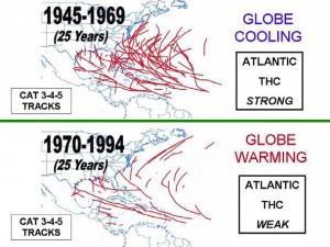
The popular press regularly warns us that on-going global warming will increase the frequency of hurricanes, and their intensity, allegedly due to warmer sea-surface temperatures in the mid-ocean hurricane-spawning areas. Klotzbach and Gray do not believe this. They studied the paths of all severe hurricanes (category 3, 4 or 5) for the fifty years from 1945-1994, dividing this time frame into two 25-year periods (see image).

Tracks of severe Atlantic hurricanes, 1945-1994

Tracks of severe Atlantic hurricanes, 1945-1994. Source: Klotzbach and Gray, 2010. Link to original article at end of this post. Click image to enlarge.

From 1945-1969 was a period of weak global cooling. There were 80 severe hurricanes in this period, some of them taking very erratic paths, with correspondingly dramatic impacts when they struck areas wholly unprepared.

Between 1970 and 1994, the Earth’s temperatures underwent a modest rise (global warming). However, in stark contrast to popular belief, far fewer severe hurricanes occurred during this period (38 in total), and they tended to follow entirely predictable paths.

Clearly the science behind hurricane formation is more complicated than some journalists would have us believe!

Klotzbach and Gray demonstrate the importance of the Thermohaline Circulation (THC) in the Atlantic. The THC is a large-scale circulation in the Atlantic Ocean that is driven by fluctuations in salinity and temperature. The 1945-1969 period coincided with a strong THC, whereas the 1970-1994 period was a time when the THC was weak.

What has happened since 1994? In the fifteen years from 1995-2009 inclusive, the THC was strong, and there were 56 severe Atlantic hurricanes. By comparison, in the preceding fifteen years from 1980-1994, when the THC was weak, only 22 severe hurricanes formed. So it appears that hurricane frequency is not linked to global warming or carbon dioxide (CO2) levels in the atmosphere, but to cyclical changes in the THC.

How accurate are the predictions for the 2010 hurricane season? Only time will tell…

Click here for Klotzbach and Gray’s original article (pdf).

Hurricane warnings in Mexico are the responsibility of the National Meteorological Service (NMS). The NMS also provides an archive of information about past hurricanes.

Hurricanes and other climatological phenomena are analyzed in chapters 4 and 7 of Geo-Mexico: the geography and dynamics of modern Mexico. Buy your copy today, so you have a handy reference guide available whenever you need it.

Jun 262010
 

Hurricanes are also known as typhoons or tropical cyclones. The table shows the World Meteorological Organization’s official list of 2010 hurricane names.

Atlantic, Gulf of Mexico and CaribbeanEastern Pacific
AlexAgatha
BonnieBlas
ColinCelia
DanielleDarby
EarlEstelle
FionaFrank
GastonGeorgette
HermineHoward
IgorIsis
JuliaJavier
KarlKay
LisaLester
MatthewMadeline
NicoleNewton
OttoOrlene
PaulaPaine
RichardRoslyn
SharySeymour
TomasTina
VirginieVirgil
WalterWinifred
Xavier
Yolanda
Zeke

Hurricane Darby is currently off the Pacific coast. It is the second major hurricane so far this hurricane season, the first being Hurricane Celia. As of June 25, Hurricane Celia is well out to sea, while Hurricane Darby is a Category 3 storm, with maximum sustained winds near 115 mph (185 kph). Hurricane Darby  is located about 265 miles (425 kilometers) southwest of Acapulco, and heading west-northwest (ie out to sea) at about 6 mph (9 kph). Neither hurricane looks likely to affect land areas.

We are still waiting for the first fully-fledged hurricane to develop on the other side of Mexico.

Note that male and female names alternate. Names are often reused in future years, with the exception of the names of any particularly violent storms, which are officially “retired” from the list for a long time.

Hurricanes and other climatic hazards are analyzed in detail in chapter 4 of  Geo-Mexico: the geography and dynamics of modern Mexico.

Feb 212010
 

A powerful earthquake struck the town of Ocotlán in the state of Jalisco, on 2 October 1847. The following day, the Mayor of Ocotlán J. Antonio Ximénez wrote to advise the State Governor:

Yesterday, Saturday the 2nd [of October 1847] at seven thirty in the morning a strong earthquake, which lasted more than five minutes, was felt in this town. It did not, however, cause any damage. The repetition, happening between nine and ten o’clock on the same morning, was terrible. In an instant, some of the town’s buildings were knocked down, and the others were completely destroyed or in imminent danger of collapse.

As of yesterday, 46 persons of both sexes, and of various ages, had been found dead, and it is not possible now to know with certainty the number of injured and wounded who miraculously escaped the destruction. It was not only the town that suffered this misfortune. The same thing occurred in all the other places in the municipality. There was terror and fright everywhere, especially when rocks broke away from the hill and the wild animals were terrified.

This morning, your Excellency, 24 hours after the unfortunate events, the perfect image of Our Lord Jesus Christ on the Cross was seen between west and north, formed between two clouds and lasting for half an hour: in which time more than 1,500 people who were in the plaza fell to their knees, performing acts of contrition and crying to the Lord to show mercy…

From the ruins of Ocotlán, October 3, 1847.
J. Antonio Ximénez

[This post is an edited extract from Lake Chapala Through the Ages, an anthology of traveller’s tales]

Earthquakes in Mexico are discussed in detail in chapter 2 of Geo-Mexico: the geography and dynamics of modern Mexico.

Giant whirlpool swallows several boats in 1896

 Other  Comments Off on Giant whirlpool swallows several boats in 1896
Feb 152010
 

An anonymous writer in the Los Angeles Times edition of 13 January 1896, reported on a strange and terrifying happening that struck the western part of Lake Chapala (Mexico’s largest natural lake)…

Startling Spectacle at Lake Chapala.

  • Its Waters Swallowed by a Subterranean Cave.
  • Several Pleasure Boats and Their Occupants Engulfed.

SAN DIEGO, Jan. 12.—(Special dispatch.) Prof. E. H. Coffey of this city, has just received a letter from a correspondent. living near Lake Chapala, State of Jalisco, Mex.. which describes some startling phenomena occurring. Lake Chapala is a sheet of water fifty miles long and ten miles wide. The formation of the country around it is purely volcanic.

On the forenoon of January 8 residents in one of the small settlements near the western end of the lake were terrified to see a gigantic whirlpool raging far out on the water. The waters rose in great serpentine movements, and from all directions rushed toward a common center, where a vast cavity seemed to exist. At the same time a heavy, rumbling sound, apparently in the bowels of the earth, took place. The whirlpool was caused by the sudden sinking of a large portion of the lake’s bottom, and before the disturbance subsided several pleasure-boats were drawn into the whirlpool and disappeared with their occupants. It is estimated that a score of lives were lost.

The whirlpool continued for nearly twenty minutes, and when the inhabitants of the surrounding territory turned their eyes from the overwhelming sight they saw that the lake had receded several feet from its former shore line. As the lake is about fifty miles in length, with an average width of ten miles, the enormous amount of water that was swallowed up by the earth may be imagined. After the whirlpool subsided the surface of the lake resumed its placid aspect, and the subterranean rumblings ceased.

There was the greatest excitement among the people for miles in the vicinity of the western end of the lake, the most ignorant and superstitious natives being beside themselves with fear. Years of familiarity with volcanic eruptions and terrestial disturbances did not seem to reassure them during this dreadful experience.

[This post is an edited extract from Lake Chapala Through the Ages, an anthology of traveller’s tales]

Natural hazards in Mexico are discussed in detail in chapters 2, 4 and 7 of Geo-Mexico: the geography and dynamics of modern Mexico.

The 1568 earthquake in Mexico

 Other  Comments Off on The 1568 earthquake in Mexico
Feb 112010
 

Historian Matias de la Mota Padilla, writing in his 1742 Historia del reino de Nueva Galicia en la América Septentrional, relates how,

On December 30, of the year 1567, several comets having given warning, an earthquake followed which ruined various churches. Already, on July 15, Lake Chapala had risen so much that it destroyed all the buildings in its village although, on account of divine providence, not a single person perished, not in Chapala, nor in the other places with the destruction of the churches.

It was not like this with the tremor that was experienced on December 27 of the following year, 1568, in which the church of Cocula collapsed, wretchedly taking Father Esteban de Fuente Obejuna, its founder. On the same day, the church in Tzacoalco [Zacoalco] fell, and sixty Indians perished, and with them also Father Hernando Pobre, who had founded it. Also so many birds were seen flying that they obscured the sun, so unusual that they provoked admiration in all who saw them.

Comparison of historical records such as this one suggests that the Chapala area of Jalisco was seismically active from 1564 to 1568. The largest earthquake, causing the collapse of many churches, houses and friaries, occurred on December 27, 1568. There were widespread reports of damage. The main chapel in Chapala was destroyed.

The pattern of damage suggests that this earthquake had a magnitude of about 7 on the Richter scale. According to one of the Geographic Accounts for the region, landslides dammed the Ameca river for three weeks, and when the river flow resumed, the water was “of a reddish color that made it impossible to drink for many days.” Large cracks appeared in the lowlands. The flow of natural springs was changed, and the level of Lake Zacoalco was altered.

The earthquake’s epicenter was close to the junction of three major rift valleys, each with its own parallel systems of faults. The first is occupied by Lake Chapala, the second follows the Tepic-Zacoalco depression, and the third includes Sayula and Colima. The movement is part of the gradual splitting of a large triangular block (on which sits Puerto Vallarta) away from the Mexican mainland. This will eventually result in the formation of a new island, a topic explored further in chapter 2 of Geo-Mexico: the geography and dynamics of modern Mexico.

[This post is an edited extract from Lake Chapala Through the Ages, an anthology of traveller’s tales]