The world’s largest crystals and strange microbes grow in caves in Chihuahua, Mexico

 Excerpts from Geo-Mexico, Updates to Geo-Mexico  Comments Off on The world’s largest crystals and strange microbes grow in caves in Chihuahua, Mexico
Feb 182017
 

The Naica caves, in the northern state of Chihuahua are home to the world’s largest natural crystals. The crystals are selenite, said to enhance sex drive.

The formation of the crystals caves is described in more detail below, but in February 2017, Penelope Boston, head of Nasa’s Astrobiology Institute announced that “bizarre and ancient microbes” had been found in these caves. The discovery came after nine years of work and was first announced at the American Association for the Advancement of Science conference in Boston. The life forms in the Naica caves survive by living on minerals such as iron and manganese and could be 50,000 years old. The find is still subject to peer-review and independent confirmation:

How were the crystals discovered?

Early in 2001, news emerged of a truly extraordinary discovery in caverns deep under the earth in the state of Chihuahua. Miners tunneling through the Naica Hills, south of Chihuahua City, in search of silver and zinc, found huge mineral crystals, far larger than any natural crystals previously seen anywhere else on the planet.

The monster crystals, over six meters long, are made of selenite, a crystalline form of the mineral gypsum (the number one ingredient in blackboard chalk!). For its pale translucence, this form of gypsum is known as selenite, named after Selene, the Greek goddess of the moon.

The largest crystals are over 11 meters long, and weigh more than 55 tons. Scientists believe they have found DNA from ancient bacterial life trapped in air bubbles inside the crystals.

The crystals formed when the caverns were completely filled with hot water (warmer than 50 degrees C) supersaturated with calcium sulphate (gypsum) for very long periods of time. The estimated growth rate, confirmed by uranium-thorium dating, is 1.5 mm per 1000 years, which means that the longest crystals took more than 500,000 years to form.

The engineer working for the mining company Peñoles that first reported these caves believes that many more caves probably exist, but stresses that they would never have been located at all if it had not been for the mine’s massive pumps (pumping more than 16,000 gallons of water out each minute) working round the clock for years. This pumping has lowered the water table from 100 meters below the surface to about 300 meters in the area of the mines. Since the caverns have been drained, the crystals are no longer growing, and the temperatures in the cavern have fallen by about 0.5 degrees C each year.

The Naica (“shady place”) hills have been actively mined for more than a century. Even though early prospectors discovered silver here in 1794, the first formal mining claim was not made until a century later in 1896, by one Santiago Stoppelli, and large scale mining only began in 1900.

Ten years later, super-large sword-shaped crystals of selenite were found in a cavern at a depth of 120 meters. Over the years, a steady stream of geologists and mineral collectors have visited this 70-meter-diameter cave, since renamed the Cave of the Swords, which is now equipped with paths, lights and a ventilation system. Even with this system, the temperature in the cave is a stifling 40 degrees C! Several typical examples of selenite crystals from this cave, ranging in length from 1.2 to 1.6 meters (4 to 4.25 feet), are displayed in the Smithsonian’s National Museum of Natural History.

But these specimens from the Cave of the Swords are small fry in size when compared with the latest discoveries, 300 meters below the surface, in the Cave of the Crystals. In two relatively small chambers, each the size of a small apartment, miners found incredibly large selenite crystals, some over six meters long. The crystals combine to form massive fifteen-meter-long columns, “the size of pine trees”, as well as hundreds of formations shaped like sharks’ teeth, jutting about a meter up from the cave floor. The overall effect is, in the words of Richard Fisher, an Arizona-based photographer and adventurer, like walking into an enormous geode.

The Future

Mining operations at Naica have been in the hands of the Peñoles group since 1961 and the mine, one of the most productive in Chihuahua, still produces ample quantities of lead, silver and zinc.

Even if the silver ore is eventually worked out, Peñoles realizes that the caverns might have a very bright future as a major geo-tourist attraction. The company has not only taken steps to safeguard the crystals, but was already developing a tourism plan, which involved the installation of an air-conditioning system in the caverns, since the temperature in the Cave of Crystals is a mind-boggling 60 degrees Celsius. This heat, combined with the 100% humidity in the caverns, is so suffocating and disorienting that researchers can only safely spend a few minutes at a time studying this fantastic sight.

The harsh conditions have not deterred crystal looters who are already reported to be breaking through padlocked doors and trying to chisel prize specimens off the cave walls. This is a dangerous business and the effort proved fatal for one would-be collector when the gigantic crystal he was attempted to sever broke away from the ceiling and crushed him as it fell. The combined physical forces of Newton and Darwin caused this particular plunderer to meet his maker!

It was announced in October 2015 that Peñoles had been forced to close its Naica mine indefinitely, following its failure to reduce the level of water in the mine following a flood in January 2015. The company was seeking to redeploy more than 400 workers. In 2014, the Naica mine produced 19,694 tons of lead, 15,399 tons of zinc and 1.9 million ounces of silver (25% 6% and 3% respectively of the company’s total output of each metal).

Whether or not attempts will be made in the future to allow access to view the crystals is unknown. It is perfectly possible that other miners in the region might be lucky enough to find even bigger crystals nearby!

These cavers may never be suitable for sustainable tourism. To preserve these magnificent crystals for future generations, the decision may have to be taken to leave the caverns under water, protecting the crystals that already exist and allowing new ones to grow.

These amazing crystals are one of the latest additions to the incredible list of natural wonders that can be enjoyed in Mexico!

For truly amazing images of the crystals, watch the Discovery Channel documentary “Naica: Secrets of The Crystal Cave” (2008).

Note:

  • This is an update of a post originally published in 2010

Mexico’s geology, relief and landforms are analyzed in chapters 2 and 3 of Geo-Mexico: the geography and dynamics of modern Mexico. Buy your copy of this invaluable reference guide today!
Plans afoot for several mini-refineries in Mexico

 Mexico's geography in the Press, Updates to Geo-Mexico  Comments Off on Plans afoot for several mini-refineries in Mexico
Aug 292016
 

State-owned Pemex currently has six oil refineries in Mexico, which process around 1.05 million barrels/day (b/d) of crude.

The company has now shelved plans to add a $10-billion refinery at Tula (Hidalgo) owing to doubts about its long-term viability. It does seem that it is unlikely to be needed since Mexico’s energy reforms have led to several private companies submitting proposals to build less expensive, modular “mini-refineries” in Mexico. Each of these mini-refineries is 80-90% smaller than any of the six giant Pemex refineries.

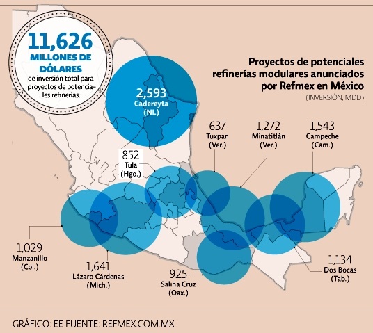
Planned new refineries. Credit: El Economista / Refmex.com.mx

Planned new refineries. Credit: El Economista / Refmex.com.mx

A consortium of U.S. firms, Refinerías Unidas de México (Refmex), plans to invest 11.6 billion dollars to build 9 mini-refineries, starting with a $1.5billion refinery in Campeche with the capacity to refine between 40,000 and 60,000 b/d. Construction would take between 18 and 30 months.

Other proposed locations (map) include Cadereyta (Nuevo León), Dos Bocas (Tabasco), Minatitlán (Veracruz), Lázaro Cárdenas (Michoacán), Manzanillo (Colima), Salina Cruz (Oaxaca), Tula (Hidalgo) and Tuxpan (Veracruz). Several of these locations are in the recently announced federal Special Economic Zones, which offer fiscal incentives to investors.

Related posts:

Aug 152016
 

Avid Geo-Mexico readers will know that we included a few paragraphs about the Happy Planet Index in our 2010 book, which we later quoted in this 2013 post, Mexico and the Happy Planet Index.

The latest (2016) Happy Planet Index (HPI), which uses slightly modified criteria, shows that Mexico has risen to 2nd place in the world rankings, behind Costa Rica, but ahead of Colombia, Vanuatu and Vietnam and well ahead of the U.S. (#108) and Canada (#85).

The Happy Planet Index is a compound index that combines four measures:

  • life expectancy
  • well being (life satisfaction)
  • ecological footprint
  • inequality

The HPI looked at data for 140 countries. For life expectancy, Mexico ranked #39, for well being #11, for ecological footprint #77 and for inequality #60.

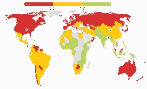
Global pattern of ecological footprint. Source: HPI report, 2016.

Global pattern of ecological footprint. Source: HPI report, 2016.

The world map for ecological footprint shows the global pattern. The colors show three categories for ecological footprints, those below 1.7, those between 1.7 and 3.5 and those that exceed 3.5, where the numbers are global hectares (gha) per person.

These two sections from the Happy Planet Index country report for Mexico are a useful snapshot of where Mexico stands right now:

What’s working well in Mexico?

In recent years, massive steps have been taken to improve the health of the population of Mexico – notably achieving universal health coverage in 2012, making essential health services available to the entire population.

In 2014, a tax was imposed on sugary drinks with the express aim of tackling of obesity – this despite strong corporate opposition. The tax had already led to a 12% decrease in the consumption of such drinks by the end of the year.

Environmental sustainability is receiving growing political attention, and was included as one of five key pillars in Mexico’s National Development Plan for 2007–12. Mexico was the second country in the world to incorporate long-term climate targets into national legislation, and is taking important steps to conserve its forests and protect its rich biodiversity.

What could be improved?

Significant challenges remain for Mexico: economic inequality is a massive problem with a considerable gap between the richest and poorest – the top 20% of the population earns more than thirteen times as much as the bottom 20% of the population.

Mexico’s poverty rates are particularly high among indigenous people. Amnesty International has  highlighted Mexico’s human rights violations, especially relating to irregular migrants. On top of these issues, the importance of the oil industry to Mexico’s economy complicates its environmental efforts.

Mexico recently reached cross-party agreement on the Pacto por Mexico, a pact of 95 initiatives aiming to tackle some of these issues – an important step for the country’s future.

The HPI attempts to quantify an alternative vision of progress where people strive for happy and healthy lives alongside ecological efficiency in how they use resources. Mexico may have a high happiness index, but (like the rest of the world) it still has an awful long way to go to ensure a sustainable future for our grandchildren.

Related posts:

Which states grew fastest in 2015?

 Updates to Geo-Mexico  Comments Off on Which states grew fastest in 2015?
Aug 112016
 

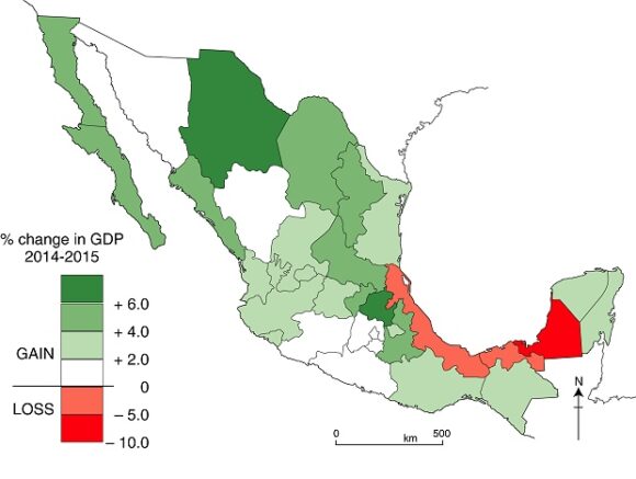
The map shows the percentage change in each state’s GDP during 2015. (Data from the National Statistics Agency, INEGI).

Change in GDP, by state, 2014-2015. Data: INEGI. Cartography: Tony Burton / Geo-Mexico

Change in GDP, by state, 2014-2015. Data: INEGI. Cartography: Tony Burton / Geo-Mexico

The fastest growing states in 2015 were Hidalgo (6.3%), Chihuahua (6.2%) and Nuevo León (5.9%).

While the economy of most northern Mexico states grew at a respectable rate during 2015, the economies of three Gulf coast states actually shrank last year, mainly owing to the drop in oil prices. GDP fell in three oil-rich states: Campeche (- 8.2%), Veracruz (- 2.3%) and Tabasco (- 0.2%).

Related posts:

Aug 012016
 

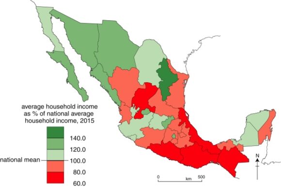
The National Statistics Agency’s (INEGI’s) 2015 Survey of Socioeconomic Conditions includes data for average household incomes in Mexico, on a state-by-state basis. The national average household income (for a three month period) is $45,887 (pesos) . The map below shows how each state’s average household income compares to the national average.

Household income, by state, 2015. Data: INEGI. Cartography: Tony Burton / Geo-Mexico; all rights reserved

Household income, by state, 2015. Data: INEGI. Cartography: Tony Burton / Geo-Mexico

The state with the highest household income is Nuevo León, with $66,836, more than 140% of the national average. The state with the lowest household income is Guerrero ($27,584), where the average household income is only 60.1% of the national average. Guerrero’s average household income is only 41% of the average for Nuevo León.

As we have regularly highlighted in the past, regional differences in Mexico are considerable, and a definite “north-south divide”can be identified for almost every socio-economic variable. Development efforts need to be focused on improving the key indicators for southern Mexico and reducing these regional disparities.

Related posts:

Instant poverty reduction – just change the baseline

 Mexico's geography in the Press, Updates to Geo-Mexico  Comments Off on Instant poverty reduction – just change the baseline
Jul 282016
 

The latest report on poverty from the National Statistics Agency, INEGI, looks like good news for Mexico’s poorest people but, sadly, this is only a mirage, based on a change in the measurement methods used.

The 2015 edition of INEGI’s Survey of Socioeconomic Conditions showed an overall real increase of 11.9% in household earnings, with an increase of over 30% in some states. According to the report, Mexico’s poor are richer by a third compared to last year, a change that some politicians will no doubt claim is the direct result of their effective policies.

Social activists were stunned by the claims of poverty reduction and Mexico’s National Council for the Evaluation of Social Development Policy (CONEVAL), which measures poverty levels using INEGI’s data, said the changes by the statistics institute were not credible.

According to Jonathan Heath, an independent economic researcher in Mexico City, Inegi is claiming that the previous methods overestimated poverty levels, but the change in methodology, without public consultation, “raises suspicion.”

Quite apart from the misleadingly positive spin on numbers, the change in methodology makes it completely impossible to compare current poverty rates with the rates for previous years.

Related posts:

Clean energy revolution in Mexico

 Updates to Geo-Mexico  Comments Off on Clean energy revolution in Mexico
Jul 042016
 

A recent Bloomberg analysis highlights Mexico’s “Clean Energy Revolution”. The analysis of Mexico’s electricity sector finds that total energy demand will rise 72% over the next 25 years, from 305,000 GWh in 2015 to 512,000 GWh in 2040, while installed capacity will triple, to around 247 GW.

Fossil fuels are currently the source of 78% of the electricity generated in Mexico, but renewable energy (including hydro-power) will account for 69% by 2040.

According to Bloomberg, the costs of producing wind and solar energy will become fully competitive with electricity from natural gas power stations by 2025.

The report concludes that the renewable energy sector in Mexico represents an enormous investment opportunity, worth up to $186 billion between now and 2040.

The federal government is increasing its investments in research and development of renewable energy sources each year, up to $310 million in 2020, to build more “energy innovation centers” (Cemies). The five existing Cemies focus on geothermal, solar, wind, bioenergy and ocean energy respectively. Two new Cemies will investigate the use of intelligent networks and carbon capture alternatives.

Related posts:

All Pemex refineries now making clean fuel

 Updates to Geo-Mexico  Comments Off on All Pemex refineries now making clean fuel
Jun 302016
 

Pemex has concluded a round of upgrades to its refineries which means that all fuels made in Mexico are now “clean” (ultra-low-sulfur). Pemex refineries produce 420,000 barrels of vehicle fuels a day, but national demand is for 800,000 barrels a day.

pemex

Imported fuels, which come mainly from refineries in Texas, already meet ultra-low-sulfur standards. The state oil giant has invested 1.7 billion dollars in modifying its six refineries to produce only ultra-low-sulfur fuels.

Related posts:

Jun 202016
 

Mexico is the world’s leading producer of silver and has occupied top spot for several years. Mexico’s output of silver rose 2.0% in 2015 to 5,372 metric tons (189.5 million ounces). Mexico is responsible for 21% of global production, followed by Peru (15%), China (12%) and Australia and Russia (each 6%). About 70% of silver produced in Mexico is exported, the remainder is sold on the domestic market.

Global silver production fell slightly in 2015 due to decreased output from Canada, Australia and China. World demand for silver in 2015 reached a record 33,170 tons (1,170 million ounces), due to surges in three manufacturing sectors: jewelry, ingots and coins, and photo-voltaic solar panels.

The increased output in Mexico came from expansions in the Saucito and Saucito II mines, operated by Fresnillo, and the El Cubo mine, managed by Canadian firm, Endeavour Silver. A similar increase in production is predicted this year, given the on-going expansion of the San José mine, owned by Canada-based Fortuna Silver Mines.

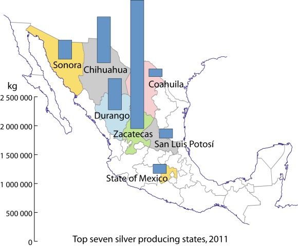
Zacatecas is Mexico’s leading silver producing state (46.5% of total; see map), well ahead of Chihuahua (16.6%), Durango (11.3%) and Sonora (6.9%).

Silver production in Mexico, 2011. Data: INEGI. Credit: Tony Burton/Geo-Mexico

Silver production in Mexico, 2011. Data: INEGI. Credit: Tony Burton/Geo-Mexico

In Zacatecas, silver mining is especially important in the municipalities of Fresnillo (24% of total national silver production) and Mazapil (15%) as well as Chalchihuites and Sombrerete (3% each). The main silver mining municipality in Chihuahua is Santa Bárbara (3% of national total). In Durango, San Dimas and Guanaceví are each responsible for about 3% of national production, while the leading municipality for silver in Sonora is Nacozari de García (1%).

The legacy of silver

The importance of silver mining in colonial New Spain can not be over-emphasized. For instance, during colonial times nearly one third of all the silver mined in the world came from the Guanajuato region!

Even today, the cities and landscapes of many parts of central and northern Mexico reveal the historical significance of silver mining. The legacies of silver mining include not only the opulent colonial buildings in numerous major cities such as Zacatecas and Guanajuato, as well as innumerable smaller towns, but also the deforestation of huge swathes of countryside.

The landscape of states like San Luis Potosí, Zacatecas and Guanajuato was forever changed by the frenzied exploitation of their woodlands. Silver mines needed wooden ladders and pit props. The smelting of silver ore required vast quantities of firewood. Barren tracts of upland testify to the success of those early silver mines. Mining played a crucial role in the pattern of settlement and communications of most of northern Mexico. The need to transfer valuable silver bullion safely from mine to mint required the construction of faster and shorter routes (see, for example, El Camino Real or Royal Road, the spine of the colonial road system in New Spain), helping to focus the pattern of road and rail communications on a limited number of major cities.

Once workable ores ran out, smaller mining communities fell into obscurity and many became ghost towns. Some of these settlements, such as Real de Catorce and Angangueo, have enjoyed a new lease of life in recent years due to tourism.

The main town associated with silver and tourism is Taxco, the center of silversmiths and silver working in Mexico.

Mining towns described briefly previously on Geo-Mexico.com include:

Note: This is a 2016 update of a post first published in 2013.

Related posts:

May 192016
 

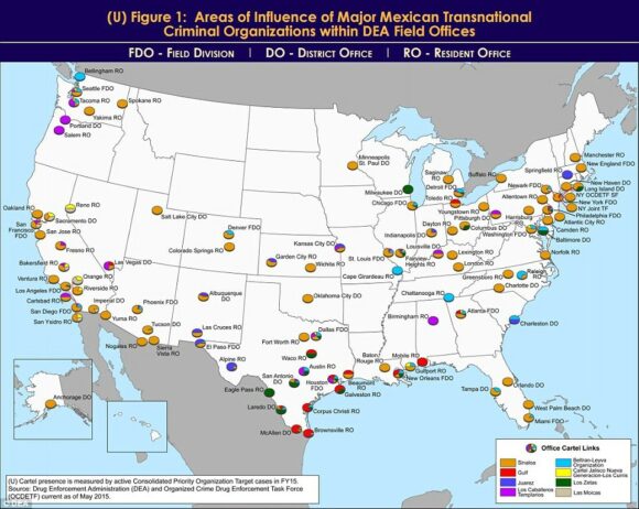
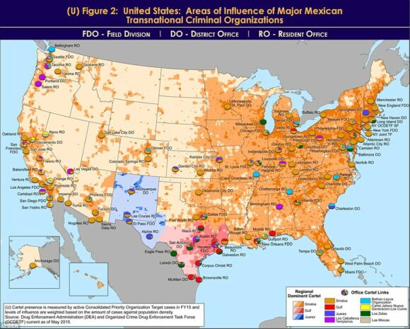
An unclassified DEA Intelligence Report from a year ago has just resurfaced on my desk. Entitled United States: Areas of Influence of Major Mexican Transnational Criminal Organizations, it includes two particularly interesting maps.

The report states that “Mexican transnational criminal organizations (TCOs) pose the greatest criminal drug threat to the United States; no other group is currently positioned to challenge them. These Mexican poly-drug organizations traffic heroin, methamphetamine, cocaine, and marijuana throughout the United States, using established transportation routes and distribution networks. They control drug trafficking across the Southwest Border and are moving to expand their share, particularly in the heroin and methamphetamine markets.”

As of May 2015, the DEA identified the following cartels that operate cells within the USA: the Sinaloa Cartel, Gulf Cartel, Juarez Cartel, Knights Templar (Los Caballeros Templarios or LCT), Beltran-Leyva Organization (BLO), Jalisco New Generation Cartel (Cartel Jalisco Nueva Generacion or CJNG), Los Zetas, and Las Moicas.

The maps reflect “data from the Organized Crime Drug Enforcement Task Force (OCDETF) Consolidated Priority Organization Target (CPOT) program to depict the areas of influence in the United States for major Mexican cartels.”

DEA-Mexican cartel influence in USA

DEA-Mexican cartel influence in USA

Figure 1 (click map to enlarge) shows the distribution of DEA Field Offices. The pie chart for each office shows “the percentage of cases attributed to specific Mexican cartels in an individual DEA office area of responsibility”.

“Since 2014, the Arellano-Felix Organization, LCT, and the Michoacán Family (La Familia Michoacán LFM) cartels have been severely disrupted, which subsequently led to the development of splinter groups, such as, “La Empresa Nueva” (New Business) and “Cartel Independiente de Michoacan” (Independent Cartel of Michoacan) representing the remnants of these organizations.”

Figure 2 (below) shows the dominant transnational criminal organization (TCO) in each domestic DEA Field Division, relative to other active TCOs in the same geographic territory. The map includes population density shading which “is intended to depict potential high density drug markets that TCOs will look to exploit through the street-level drug distribution activities of urban organized crime groups/street gangs.”

DEA-Mexican cartel influence in USA

DEA-Mexican cartel influence in USA

“The Sinaloa Cartel maintains the most significant presence in the United States. They are the dominant TCO along the West Coast, through the Midwest, and into the Northeast. While CJNG’s presence appears limited to the West Coast, it is a cartel of significant concern, as it is quickly becoming one of the most powerful organizations in Mexico, and DEA projects its presence to grow in the United States over the next year. In contrast, Mexican cartels such as the Gulf, Juarez, and Los Zetas hold more significant influence closer to the Southwest Border, but as shown on the map, their operational capacity decreases with distance from the border.”

Other, smaller, “splinter groups from the disrupted LCT organization continue to traffic drugs from the Michoacán, Mexico area into the United States. The BLO, former transportation experts for the Sinaloa Cartel, is most active along the East Coast and is also responsible for the majority of heroin in the DEA Denver area of responsibility. Las Moicas is a Michoacán-based organization with former LFM links, but remains a regional supplier in California and operate on a smaller scale relative to other major Mexican TCOs.”

Related posts:


May 122016
 

The 2016 hurricane season in Mexico for Pacific coast storms starts on 15 May and lasts until 30 November. For Atlantic storms, the hurricane season extends from 1 June to 30 November, though most hurricane activity is concentrated in the months from July to September. Hurricanes are also known as typhoons or tropical cyclones.

The table shows the World Meteorological Organization’s official list of 2016 tropical storm and hurricane names. Note that male and female names alternate. Names are often reused in future years, with the exception of the names of any particularly violent storms, which are officially “retired” from the list for a long time.

2016 Hurricane Names for the Atlantic, Gulf of Mexico and Caribbean
AlexGastonLisaRichard
BonnieHermineMatthewShary
ColinIanNicoleTobias
DanielleJuliaOttoVirginia
EarlKarlPaulaWalter
Fiona

2016 Hurricane Names for the Eastern Pacific
AgathaGeorgetteMadelineTina
BlasHowardNewtonVirgil
CeliaIvetteOrleneWinifred
DarbyJavierPaineXavier
EstelleKayRoslynYolanda
FrankLesterSeymourZeke

saffir-simpson-scale

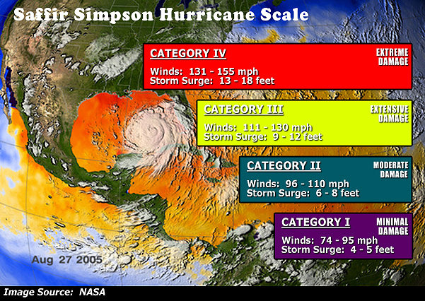
In their early season forecast for this year, Philip Klotzbach and William Gray, researchers at Colorado State University,  expect hurricane activity in the Atlantic to be near-normal (ie close to the 30-year average). They predict that in the 2016 season 13 named storms will form in the Atlantic: 5 tropical storms, 6 moderate hurricanes (1 or 2 on the Saffir-Simpson scale), and 2 severe hurricanes (3, 4 or 5 on the Saffir-Simpson scale). These forecasts will be updated on 2 June and 31 July.

Last year’s Atlantic hurricane season was slightly below average in activity with 11 named storms: 5 tropical storms, 4 moderate hurricanes and 2 severe hurricanes. On the other hand, the 2015 Pacific hurricane season was the second most active on record, with 26 named storms, including 11 severe hurricanes.

In 2016, for the Pacific coast, Mexico’s National Meteorological Service (Servicio Metrológico Nacional, SMN) is expecting 17 named storms: 8 tropical storms, 5 moderate hurricanes (1 or 2 on the Saffir-Simpson scale), and 4 severe hurricanes (3, 4 or 5 on the Saffir-Simpson scale).

For the Atlantic coast, SMN) is expecting 13 named storms: 7 tropical storms, 4 moderate hurricanes and 2 severe hurricanes. On both coasts, these predictions indicate a slight increase in storm activity compared to long-term averages. The SNM publishes regular updates on hurricane activity (in Spanish) on its webpage and via its Twitter account: @huracanconagua.

Hurricanes and other climatological phenomena are analyzed in chapters 4 and 7 of Geo-Mexico: the geography and dynamics of modern Mexico. Buy your copy today, so you have a handy reference guide available whenever you need it.

Related posts:

Trends in Mexico’s avocado-growing industry

 Mexico's geography in the Press, Updates to Geo-Mexico  Comments Off on Trends in Mexico’s avocado-growing industry
Apr 212016
 

Mexico is by far the world’s largest producer, consumer and exporter of avocados. Production topped 1.3 million metric tons last year, well ahead of the USA (240,000 tons) and Chile (205,000 tons). Mexico’s avocado exports have risen by a staggering 414% over the past eight years to more than 600,000 metric tons in 2015, worth close to US$2 billion.

logo_brands_avocados-from-mexicoThe state of Michoacán is by far the most important single state in Mexico for avocado farms and accounts for 8 out of very 10 avocados sold in the USA, according to the Association of Avocado Producers, Packers and Exporters of Michoacán (APEAM). APEAM says that more than 50% of all the avocados consumed in the world come from Michoacán. In the town of Tancítaro, one of the main centers for avocado-growing, APEAM estimates that nine out of every 10 pesos can be traced back to avocado production. Mexico’s avocado industry employs more than 300,000 people in total, 100,000 directly and over 200,000 indirectly.

Many avocado farms are quite small. Mexico has more than 12,000 avocado producers with individual farms under five hectares in size. As noted in this previous post, the clearance of land for avocado cultivation can barely keep up with the ever-increasing demand.

Problems with drug cartel activity continue. As we noted a few years ago, narcos insist on their cut of the profitable avocado business and have made life difficult for growers, traders and truck drivers. The Wall Street Journal has reported that this makes Michoacán avocados the equivalent of African blood diamonds. Avocado producers reportedly have to pay cartels up to 1,000 pesos (US$60) a hectare to avoid problems.

Cartels aside, export success looks set to continue for a while longer, since China and South Korea have now opened their markets to receive Michoacán avocados.

Related posts

Apr 142016
 

Mexico is the world’s ninth largest coffee producer and second largest producer of organic coffee. However, coffee production in Mexico in recent years has been affected by adverse weather conditions (untimely rainfall, frosts, excess humidity) which have been ideal for the expansion of coffee rust disease (roya del café) in many production areas. The 2015/16 coffee production forecast is for 3.3 million 60/kg bags (sacks), the same as the 2014-15 total production, and much lower than historical production outputs of around 5 million bags.

About 35% of Mexico’s coffee production area is located at elevations of 900 meters or higher above sea level; another 43.5% grows between 600 and 900 meters. Coffee grown at the higher elevations is generally higher quality than that grown at lower elevations.

Mexico's exports: coffee

Coffee, one of Mexico’s most important agricultural exports

Mexico has about 500,000 coffee farmers, looking after 600,000 hectares of coffee trees in twelve states. Plantations in the states of Chiapas, Veracruz, Guerrero, Oaxaca, and Puebla account for about 93% of total production. Almost all coffee-growing areas have been affected by outbreaks of coffee rust. The most affected states are Veracruz, with about 70% of the area affected, and Chiapas with about 60% of the area affected. About 40% of the coffee planted area nationwide has been affected somewhat by coffee rust.

Coffee rust is a fungal disease that can cause plant defoliation. In moderate cases, leaf defoliation reduces plants’ ability to produce fruit (the seeds of which are the actual coffee bean). In serious cases, the trees will die. The rust has spread northward from Central America, and reached Chiapas 4-5 years ago.

The Agriculture Secretariat (SAGARPA) has responded by installing about 35 nurseries in states most affected, growing coffee plant varieties resistant to rust. But these trees will need about 4 years to come into production so government officials do not expect coffee production to rebound until 2019. Sagarpa’s objective is to renew at least 250,000 hectares before the end of this administration’s term in 2018.

The SAGARPA program, aiming to increase coffee production and productivity, includes US$83 per producer as incentive, technical assistance packages of up to $140 dollars per hectare, and 500 coffee plants to renovate coffee plantations, as 80% of plants are old and less productive and often rust-prone.

However, coffee organizations complain that resources are not reaching the affected areas fast enough and that program implementation has been too localized instead of having a nation-wide strategy.

Some state governments and international companies are offering support for various types of price-enhancing certifications such as organic, Fair Trade etc. Some indigenous communities are planting their coffee trees among other trees like lime and avocado to diversify production and provide shade that helps coffee quality and enhances eligibility for value-added certifications like Rainforest Alliance and Shade Grown.

As production techniques continue to evolve, some producers have increased plant density from 2600 plants per hectare to 5000 plants per hectare.

Recent figures suggest that about 96% of Mexico’s coffee is of the Arabica variety. The remaining 3-4% is the Robusta variety, used in the production of instant coffee. Mexico is importing large quantities of Robusta variety coffee beans as the large Nestle plant in the city of Toluca has been increasing its output of instant (soluble) coffee. However, Nestle has also increased the use of Arabica coffee in its products. SAGARPA is now supporting the planting of Robusta coffee to decrease coffee bean imports and to support Mexico’s goal of becoming a major producer of soluble coffee.

Mexico is also producing excellent organic coffee, a trend which is increasing among producers. However,  coffee rust has hit areas of organic coffee more than conventional plantings. According to SAGARPA, about 7 to 8% of growers are cultivating organic coffee, mainly for export.

About 40% of Mexican coffee production is marketed for local consumption, according to AMECAFE, and the remaining 60% is for export. The USA continues to be the main international market for Mexican green coffee beans.

Domestic consumption

Coffee consumption in Mexico has been increasing, with estimates of up to 2.6 million 60 kg. bags total usage this year, and consumption (of roasted and soluble coffee) at between 1.3 and 1.5 kg/person.

The importation of coffee is expected to rise in 2016, in order to meet domestic demand.

Increased consumption has been driven by government and retail advertising and by the growing number of specialty coffee shops in Mexico. (Starbucks alone has opened 500 coffee shops in Mexico). Soluble coffee still makes up about 68% of domestic consumption but ground coffee consumption is increasing among the middle class, whilst high-income consumers often want fashionable value-added imported coffee.

Related posts

Gender disparities and the value of women’s work in the home

 Mexico's geography in the Press, Updates to Geo-Mexico  Comments Off on Gender disparities and the value of women’s work in the home
Apr 072016
 

In August 2012, in The value in Mexico of unpaid work in the home, we saw that a study by the National Statistics Institute (INEGI) based on 2010 data had calculated that routine work done in the home (almost 80% of the time-value involved comes from women) was worth about 2.9 trillion pesos to the Mexican economy each year, equivalent to more than 20% of Mexico’s GDP. The INEGI calculations included the costs in time/labor needed to meet the demands of the home, and the net salary that would be paid for someone undertaking similar tasks.

INEGI has just published updated statistics on this topic.  In 2014, unpaid work by women in the home was equivalent to 18% of GDP. This figure means that female contributions in the home continue to make a greater contribution to national GDP than manufacturing (16.7%), commerce (15.5%) or education (4.1%).

The latest INEGI figures show that for every 10 hours that women work (paid or unpaid), men work only 8.3 hours. According to INEGI, the average value of unpaid work by women in the home in rural areas amounted to  51,808 pesos a year (about US$4300 at the then rate of exchange). The value for women married or living with a partner was 61,456 pesos, compared to 26,082 pesos for single women. The average in households which included children under 6 years of age was 60,628 pesos.

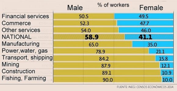
Of 29 million Mexicans in employment (in 5.7 million economic units), women account for 43.8% (graph):

% of women in different sectors of the workforce

% of women in different sectors of the workforce, 2014

The figures do reveal a slight decrease in gender inequality since the employment of women is rising slightly faster than that of men, by about 2.0%/year compared to the overall figure of 1.4%/year. In 2014, about 50% of service workers, 34.5% of manufacturing workers, and 11.0% of construction workers were female.

Related posts:

Mar 072016
 

Tourism accounts for about 9% of Mexico’s GNI and provides almost 4 million direct jobs. In 2015, Mexico welcomed a record 32.1 million international tourists, making it the 10th most popular international destination in the world. They spent a combined $17.5 billion in the country. Almost 50% of these overseas visitors arrived by air; they accounted for 80% of total foreign tourist expenditures.

Mexico_Tourism

This year, tourism officials are predicting that 35 million international foreign visitors will holiday in Mexico, with total spending of 19 billion dollars. Officials believe, probably optimistically, that Mexico can attract 40 million tourists in 2018 and 50 million by 2030. They stress the need for policies that will result in more hotels, additional air routes, new attractions, and packages designed for niche markets including health, religion, and seniors-based tourism.

Related posts:

New era for Federal Electricity Commission as it is split into four divisions

 Mexico's geography in the Press, Updates to Geo-Mexico  Comments Off on New era for Federal Electricity Commission as it is split into four divisions
Feb 112016
 

Mexico’s state-owned Federal Electricity Commission (Comisión Federal de Electricidad, CFE) has remained the dominant electric utility in Mexico for almost eighty years, even though most Latin American countries ended state monopolies in the 1990s. Now, Mexico’s on-going energy reforms are revamping the CFE behemoth by splitting it into four distinct entities focusing, respectively, on electricity generation, transmission, distribution and commercialization.cfe-619x348

  • Generation: CFE’s total installed capacity is 55,118 MW, coming from 628 generating units in 185 power stations.
  • Transmission: Mexico has 115,400 km of high voltage transmission line.
  • Distribution: CFE currently has 820,602 km of mid- and low-voltage lines, 1910 substations and 1.38 million distribution transformers. Distribution to domestic users is organized via 16 regional units: Baja California, Bajío, Centro Occidente, Centro Oriente, Centro Sur, Centro Norte, Golfo Norte, Jalisco, Noroeste, Norte, Oriente, Peninsular, Sureste, Valle de México Sur, Valle de México Centro and Valle de México Norte.
  • Commercialization: Includes the sales and billing to more than 38 million end-users, as well as the operations of two CFE subsidiaries (CFE Internacional and CFE Energía) involved in international trading.

In related news, Mexico’s energy regulatory body, the Centro Nacional de Control de Energía (CENACE) is introducing a market framework. Long-term energy and capacity Power Purchasing Agreements (PPAs) can now extend 15 years, with guaranteed commercialization of all power produced by each generation unit. This should provide a welcome boost to many renewable energy projects.

Mexico is committed to generating 35% of its energy from renewable sources by 2024. Hydro-electric and geothermal power plants have been important for a long time, and significant solar and wind-energy plants have been added in recent decades. A market system involving tradable Clean Energy Certificates (Certificados de Energías Limpias, CELs) is an integral part of the reforms.

Related posts:

Does Quintana Roo share a border with Guatemala? Not any longer.

 Maps, Updates to Geo-Mexico  Comments Off on Does Quintana Roo share a border with Guatemala? Not any longer.
Jan 072016
 

The state of Quintana Roo is Mexico’s youngest state (together with Baja California Sur), though this is set to change when Mexico City is formally declared a state, probably later this year. Quintana Roo, established in 1974, is well known to tourists because its largest city is the tourist mega-resort of Cancún, on Mexico’s Caribbean coast.

The northern part of Quintana Roo has a shoreline along the Gulf of Mexico. To the west of Quintana Roo lie the states of Yucatán and Campeche. But what about the southern limit of the state? Does it, or does it not, share a border with Guatemala?

In the early 1990s, the answer to this question was certainly “yes”, but things have changed since then, and the correct answer today is “not any longer”.

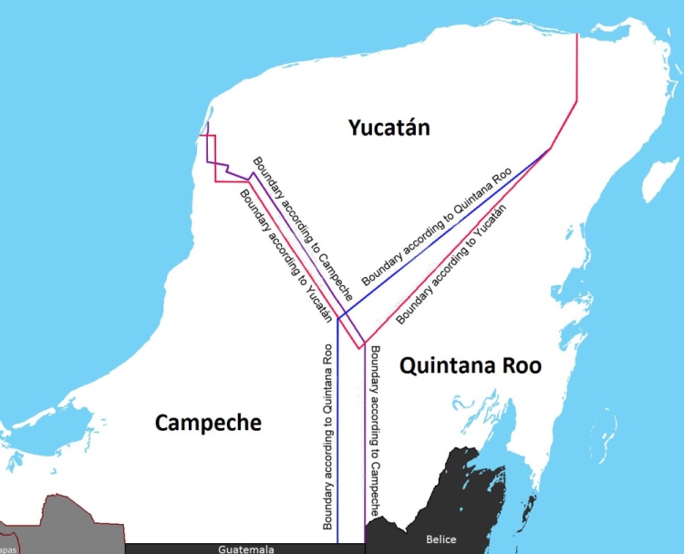
Boundary disputes in Yucatan Peninsula

  • Source: INEGI Map of the Disputed Areas

The state officially claims an area of 44,705 square kilometers (17,261 sq mi), but since 1996-97 there has  been a boundary dispute with the states of Yucatán and Campeche over an area of approximately 10,200 square kilometers (3,900 sq mi).

The contentious boundary issue arose when Campeche delimited a new municipality, Calakmul, in the south-east part of the state, and in doing so “annexed” a piece of Quintana Roo. This shifted the boundary between the two states towards the east, with a knock-on effect that the state of Yucatán also lost a small amount of territory to Campeche. However, Yucatán State simultaneously gained ground from Quintana Roo (see map). Confused? Well, that is really only the beginning, since the states of Yucatán and Campeche also dispute their shared boundary further north.

Confused administrative boundaries are never an easy thing to fix, and land boundary disputes are rife in Mexico at every level, so getting municipal, state and federal authorities to agree on a resolution takes time. The major Campeche-Quintana Roo dispute arose in the late 1990s, but was only finally settled, somewhat arbitrarily by federal court, in 2013. The court sided with Campeche, and Quintana Roo lost its border with Guatemala.

Oh dear… our Geo-Mexico map of Quintana Roo is now out of date!

Related posts:

Dec 212015
 

The National Statistics Institute (INEGI) has released the results of its inter-census study carried out in March 2015 which involved visits to more than 7 million households across the country.

Children in Zitácuaro, Michoacán. Photo: Tony Burton. All rights reserved.

Children in Zitácuaro, Michoacán. Photo: Tony Burton. All rights reserved.

As of March 2015, Mexico’s total population was 119,530,753 (48.6% male, 51.4% female), up from 111,954,660 million in 2010, a growth rate averaging 1.4% a year. This is the first time for 45 years that the rate of growth has not fallen. Analysts had expected a 1.2% growth rate over the period, but attribute the 1.4% figure to a slightly higher fertility rate than anticipated, together with an unexpected fall in the number of young people emigrating from Mexico. [Note that the total population figure is slightly lower than the figure released in July from Mexico’s National Population Council (Conapo) of 121,783,280.]

Since 2010 the proportion of seniors (over age 65) has risen from 6.2% to 7.2% of the total, and the proportion of households headed by a female is up from 25% to 29%. The median age in Mexico is now 27 years. The youngest median age is in Chiapas (23), the oldest in the Federal District (33). Overall, Mexico’s dependency ratio is falling, continuing a period of “demographic dividend“.

INEGI found that the number of households in Mexico is rising 2.4% a year and now totals about 32 million, giving an average number of 3.7 occupants/household. 98.7% of homes have electricity, 74.1% have piped water inside the building, a further 20.4% outside the building but on the property; 75.6% connected to drainage.

Mexico’s most populated states remain the State of Mexico, the Federal District (Mexico City) and Veracruz, while the smallest states in terms of population are Baja California, Campeche and Colima. The most populated municipality is Iztapalapa (1.8 million), followed by Ecatepec (1.7 million) and Tijuana (1.6 million). The most rapidly growing municipality in the entire country is Pesquería, in Nuevo León, which has grown a startling 35.2% a year since 2010, mainly because of the new Kia vehicle factory opening there.

The item of inter-census news that attracted most press attention was INEGI’s so-called discovery that there were 1.4 million black Mexicans. This was hardly news to most demographers, but the inter-census survey was the first time INEGI had included a question aimed at identifying Afro-Mexicans, as a pilot question for the full 2020 census: “Based on your culture, history and traditions, do you consider yourself black, meaning Afro-Mexican or Afro-descendant?”

INEGI did indeed find that about 1.4 million citizens (1.2% of the population) self-identified as “Afro-Mexican” or “Afro-descendant”, with significantly more women opting for the category than men (755,000 women; 677,000 men).

It was no surprise to find that most Afro-Mexicans live in the states of Guerrero, Oaxaca and Veracruz. The survey showed that Mexico’s self-identified black population is not currently disadvantaged in terms of access to education and health services or work opportunities, putting it well ahead of Mexico’s indigenous population in that regard.

Afro-Mexican activists welcomed the inter-census question and results, but called for Mexico’s history books to reflect their contribution. Benigno Gallardo, an Afro-Mexican activist in Guerrero, pointed out that, “In school they teach our children about Europeans and indigenous natives, but the history books practically don’t recognize our history.”

Certainly more awareness of the long history of Afro-Mexicans is badly needed. For example, how many people realize that Blacks outnumbered Spaniards in Mexico until after 1810 or that Vasconcelas’ “Cosmic Race” (La “Raza Cósmica”) excluded Mexico’s African heritage?

Want to learn more? A good place to start is Bobby Vaughn’s website Afro-Mexico or his Black Mexico Home Page, Afro-Mexicans of the Costa Chica, on MexConnect, which provide links to several of his articles including Blacks in Mexico. A Brief Overview.

Related posts:

Nov 292015
 

Line 12 of Mexico City’s Metro (subway) system was originally opened in October 2012. The new line, also known as the Golden Line, extended the city’s metro system into several lower income areas in the south-eastern part of the city, including Tlahuac, Milpa Alta, Xochimilco and Iztapalapa.

However, in March 2014, the elevated (above ground) 14-kilometer-long (9 mi) southern section of this line between Tlahuac and Atlalilco stations was closed for emergency repairs. A replacement bus system was established between those stations. According to a report in the Mexico City daily Reforma (citing a study by ILF Consulting Engineers), the design of tracks in that section had resulted in damage to the wheels of several metro trains. It also resulted in the failure of an electric cable and caused cracks and fractures in the track supports. Authorities have blamed some former city officials, together with the line’s builders, a consortium comprised of France’s Alstom and the Mexican companies ICA and Carso.

Metro Line 12 was finally fully reopened 20 months later, on 29 November, 2015. Line 12 is the longest line in the city’s metro network,extending 25 km (15.5 miles), with 20 stations, including four transfer points. In terms of network connectivity, it added an important east-west link connecting four lines that serve the southern section of the metro area. Line 12 runs from Mixcoac (Line 7) to Tlahuac in the southeast of Mexico City, intersecting with line 3 at Zapata, line 2 at Ermita and line 8 at Atlalilco.

Mexico-City-Metro-MapOfficials estimate that the line, which has both underground and overground sections, eliminates 860 buses from the city’s congested streets, reducing carbon dioxide emissions by 22,000 metric tons a year. It cost about $1.8 billion to construct.

Mexico City metroBetween 400,000 and 450,000 passengers are now expected to use Line 12 daily. It is expected to cut the average daily commuting time from those parts of the city it serves by more than an hour a day, from 150 minutes to 78 minutes. The line is only accessible by using the new metropolitan smart transport card “Tarjeta DF”.

The complete network of 12 lines comprising Mexico City’s metro system, used by more than 5 million passengers a day, now has 195 stations and a total length of about 227 km (141 miles).

Will the line eventually be extended?

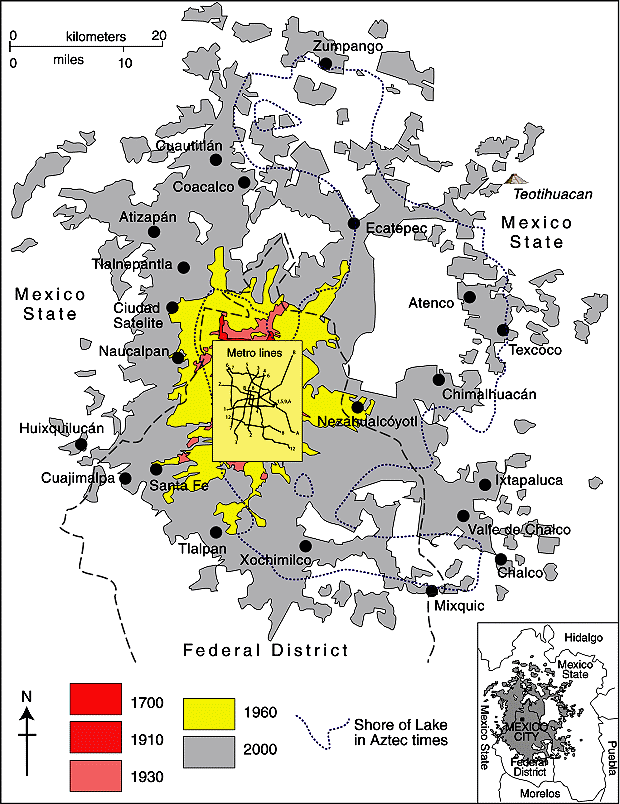
In January 2013, officials of Mexico City’s Metro system (Sistema de Transporte Colectivo, STC)  announced that they were considering extending Line 12 westwards into the Álvaro Obregón district of the city. This is still being talked about. STC’s Managing Director Joel Ortega Cuevas also said that an analysis was needed of the viability of extending the Metro network to reach several major commuting routes in the State of México (see map), including Ecatepec-Coacalco-Zumpango; Chalco-Ixtapaluca; Naucalpan-Tlalnepantla-Cuautitlán; Atizapan-Naucalpan and Chimalhuacan-Nezahualcóyotl.

Spatial growth of Mexico City Metropolitan Area (based on Geo-Mexico Fig 22.2; all rights reserved)

Spatial growth of Mexico City Metropolitan Area (based on Geo-Mexico Fig 22.2; all rights reserved)

Useful links:

Related posts:

Nov 232015
 

As we discussed in this earlier post, historical analysis combined with greater climatological understanding shows that many of the worst droughts and floods in Mexico have been associated with either El Niño Southern Oscillation (ENSO) events or with the related Pacific-North American Oscillation. Perhaps 65% of the variability of Mexican climate results from changes in these large-scale circulations.

The World Meteorological Organization (WMO) says the 2015-2016 ENSO is expected to be one of the three most powerful ENSO events since 1950 with effects that will last for up to eight months.

What will this winter’s El Niño bring? 

  • slightly higher ocean water temperature off west coast; some fish species may migrate northwards
  • some winter rain in north-west
  • increased winter storms, and cooler temperatures, along east coast; risk of flooding, mudslides
  • reduced summer rainfall in Mexico’s central highlands; risk of drought and lower crop yields

This winter, according to the Center for Scientific Investigation and Higher Education of Ensenada (CICESE), the Baja California Peninsula is likely to receive more rain than usual during this year’s very strong ENSO (El Niño) event.

The distribution of fish species is likely to change as the ocean temperatures are higher than usual, resulting in the migration of some species, leaving fewer fish off the coast of Baja California, one of the world’s most important commercial and sports fishing zones. Sardine fishermen may have a difficult season, incurring greater costs as they try to locate viable schools of fish.

A NASA climatologist predicts that California (USA) will be on the receiving end of more winter storms (January-March), and heavier rain, than usual. This increases the risk of hazardous mudslides in some coastal communities. It could also mean more mosquitoes, and an increased chance of contracting dengue fever or chikungunya.

What is the longer term outlook?

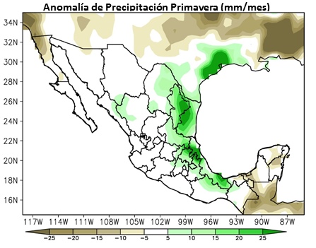
The first map shows likely precipitation anomalies for early next year (Spring). Areas shaded brown are areas expected to receive less rainfall than normal. Areas shaded light blue through green are predicted to get more rain than usual.

Spring precipitation anomalies

Spring precipitation anomalies in a strong El Niño year. Source: CNA

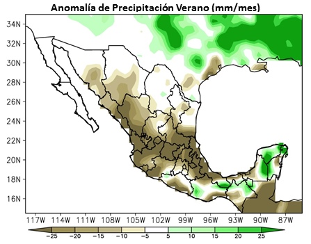
The second map shows summer precipitation anomalies. A significant reduction in rainfall is expected across most of central Mexico, though some areas in southern Mexico will likely get more rainfall than normal.

Summer precipitation anomalies in a strong El Niño year. Source: CNA

Summer precipitation anomalies in a strong El Niño year. Source: CNA

We end with one piece of good news for our more active readers. Previous El Niño events have brought great surfing to the west coast of Mexico, so make your travel and hotel plans as soon as possible.

Related posts:

More water meters for Mexico City

 Mexico's geography in the Press, Updates to Geo-Mexico  Comments Off on More water meters for Mexico City
Oct 122015
 

A recent OOSKAnews report says that Mexico City’s water authority (Sacmex) is seeking to purchase 27,835 more water meters that it plans to install in coming months. Sacmex supplies water to around 2 million separate addresses, of which 1.4 million are already metered. The latest purchase is part of Sacmex’s plan to ensure that 100% of connections to the water system are metered. Sacmex’s current budget includes $3.5 million for an additional 40,000 meters.

sacmex

At present, users without a meter pay a fixed bi-monthly tariff based on the building category, and intended type of water use (domestic/industrial/commercial).

Funding for the meters will be part of a $200 million World Bank-supported “Program to Improve the Efficiency of Operating Organizations” (PROME) which has already financed various projects across the country for urban areas with populations over 20,000. Projects already funded by the Progam include more efficient pumps, the updating of user databases with geo-referencing technology, and studies to gauge the robustness of indicators such as water pressure, water quality and leak detection.

Sacmex is also working on other distribution issues. Earlier this year – see Water in Mexico: a human right that is currently subsidized and wasted – Sacmex CEO Ramón Aguirre Diaz said that the agency required $430 million to combat leakages in the system (currently estimated at around 40% of supply), and claimed that a long-term program to fix the problem would be introduced next year.

Related posts:

Sep 282015
 

The gradual devaluation of Mexico’s Magic Towns (Pueblos Mágicos) program, reported here in earlier posts, continues with the recent addition of 28 new Magic Towns to the list, bringing the total number to 111.

Magic Towns

At the Second Annual Fair of Magic Towns, held in Puebla recently, the Federal Tourism Secretary Enrique de la Madrid announced that 28 of the 180 applicant towns had been accepted into the promotional program. The designation is supposedly reserved for “cities, towns and villages with special symbolic features, legends and history, and opportunities in tourism”, but several existing Magic Towns have very little indeed to offer tourists, and little cultural or historical significance. The same can be said for several of the latest group of 28 Magic Towns.

Towns, by state (September 2015) [corrected]

Mexico’s Magic Towns, by state (September 2015) [corrected]

Towns in the program are eligible for federal grants towards maintenance, rebuilding historic centers, improving infrastructure, installing underground utilities, developing tourism products, training and other projects. According to Magic Town proponents, the program increases visitor numbers and income by between 20 and 30%, though it is very hard to see where such positive numbers come from.

The latest 28 additions to the Magic Towns program are:

  • San José de Casas (Aguascalientes)
  • Candela and Guerrero (Coahuila)
  • Palenque (Chiapas)
  • Aculco, Ixtapan de la Sal [incorrectly given as Ixtapa de la Sal in the press release], Teotihuacán, San Martín de las Pirámides and Villa de Carbón (State of Mexico – Estado de México)
  • Tecozahutla (Hidalgo)
  • Mascota and Talpa de Allende (Jalisco)
  • Sayulita, (Nayarit)
  • Linares (Nuevo León)
  • Huautla de Jiménez, Mazunte, San Pablo Villa Mitla and San Pedro y San Pablo (Oaxaca)
  • Atlixco and Huauchinango (Puebla)
  • Isla Mujeres and Tulum (Quintana Roo)
  • San Joaquín (Querétaro)
  • Mocorito (Sinaloa)
  • Tlaxco (Tlaxcala)
  • Coscomatepec, Orizaba and Zozocolco (Veracruz)

On a positive note, it means that my Western Mexico, A Traveler’s Treasury (2013) now has descriptions and details of no fewer than 18 Magic Towns, rather than the 15 previously included!

Related posts:

Mexico’s multinationals: Mexichem, a world leader for PVC pipes and other products

 Other, Updates to Geo-Mexico  Comments Off on Mexico’s multinationals: Mexichem, a world leader for PVC pipes and other products
Sep 202015
 

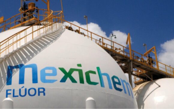
Mexichem is a Mexican chemical and petrochemicals company (2014 total revenues: US$ 5.6 billion), with headquarters in Tlalnepantla, in Greater Mexico City. Mexichem is a world leader in making and marketing plastic pipes and other products required in the infrastructure, housing, telecommunications, drinking and potable water sectors.

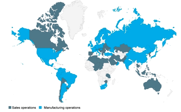
It employs 19,200 workers and has 120 manufacturing operations in more than 30 countries, with a sales presence in 90 countries.

Mexichem operations, 2015

Mexichem operations, 2015 (Source: mexichem.com)

The company’s origins date back to 1953 when a group of Mexican and English investors founded Cables Mexicanos S.A. to make high carbon steel wire ropes. Several changes of name and owners later, it emerged in 2005 as Mexichem. Mexichem has grown rapidly since then, largely due to an aggressive series of acquisitions.

In 2006, Mexichem bought Bayshore Group (PVC compounding). In 2007, it bought Amanco (PVC pipe systems and fittings), Petroquímica Colombiana (maker of PVC resins) and DVG, Industria e Comércio de Plásticos (producer of rigid PVC water and sewage pipes).

In 2008 Mexichem acquired Fluorita de Río Verde (fluorspar production plants and two fluorite mining concessions), Quimir (sodium phosphates), Geotextiles del Perú (geotextiles), Fiberweb Bidim Industria e Comércio de Não-Tecidos (Brazilian geotextile producer) and Colpozos (Colombia’s leading supplier of irrigation and well drilling systems).

The list goes on in succeeding years, with a succession of acquisitions of companies making PVC pipes, connections, polymers, resins, and fluorochemical competitors to become a world leader in the fluorine chemical segment, particularly in the production of refrigerant and medical gases.

mexichem-fluor

To consolidate its fluorite business, in 2012, Mexichem bought Fluorita de México, ensuring access to the highest pure fluorspar available worldwide.

Mexichem has four main business divisions:

  • Pipe systems, fittings, conduits and plastic accessories for the delivery of data, video, communications, electricity, water and gas. The pipe systems are made from polyethylene, PVC, polypropylene and specialty flame and smoke resistant compounds.
  • PVC resin and valuable industrial compounds based on chlorine and caustic soda. PVC has uses from pipes that carry drinking water, wastewater or water for irrigation to construction materials and products, as well as  auto parts, household appliances, clothing, footwear, packaging and medical devices. Caustic soda is used to make soap, shampoo, lotions and detergents and to treat water.
  • Fluorine-based products, technologies and services. Mexichem’s “Mine to Market” structure ensures a secure supply chain of flourine-based products for the steel, cement, aluminum, automotive, refrigeration and pharmaceutical sectors.
  • Energy. This division was created in 2014 in order to capitalize on opportunities arising from Mexico’s new energy policies.

A note on Mexico’s importance for fluorite

Exports of fluorite from Mexico were worth $180.7 million in 2014 (29% of the world total), making Mexico the world’s leading exporter of that mineral, ahead of China ($120.2 m). In 2014, Mexico mined 1.1 million metric tons of fluorite, and was the world’s second largest producer after China (4.4 million tons).

Mexichem sits on the world’s largest high-grade fluorite deposits, in its mine in San Luis Potosí. It produced 529,464 metric tons of fluorite from this mine in the first six months of 2015, 96% of the national total.

The world’s largest total reserves of fluorite are in South Africa (41 million tons), followed by Mexico (32 million), China (24 million) and Mongolia (22 million), according to U.S. government figures.

Related posts:

Mexico’s food and beverage multinationals continue to expand

 Updates to Geo-Mexico  Comments Off on Mexico’s food and beverage multinationals continue to expand
Sep 032015
 

Mexico’s seven leading food and beverage multinationals have invested a total of 7.42 billion dollars overseas in the past five years. The investments include acquisitions of other firms, building new plants and enlarging or remodeling existing plants.

The seven firms are:

  • Coca-Cola Femsa
  • Grupo Bimbo
  • Arca Continental
  • Gruma
  • Sigma Alimentos
  • Grupo Lala
  • Grupo Herdez

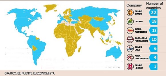
In terms of the number of countries where they have a presence, the two most globalized food and beverage firms in Mexico are Grupo Bimbo and Gruma, which are in 22 and 18 countries respectively (see map). Both firms are now quite dependent on foreign earnings. About 61% of Bimbo’s revenues, and almost 70% of Gruma’s revenues, originate from outside Mexico. Both firms have the longest reach of any of the food and beverage multinationals: Bimbo as far as China, and Gruma in Australia.

Mexican food-related multinationals

Mexican food-related multinationals are present in all the countries colored blue

In this post, we take a quick look at each of these seven firms and their recent activity abroad:

Femsa, based in Monterrey, is the world’s largest bottler of Coca-Cola products, with 45 plants in Latin America, including Colombia, Brazil and Venezuela, as well as 19 plants in the Philippines. It spent 1.855 billion dollars to buy Brazilian firm Spaipa, and a further 258 million dollars on building a new plant there (its tenth plant in Brazil), as well as 688.5 million dollars for 51% of the Coca-Cola Company in the Philippines. Femas also operates the OXXO chain of convenience stores, the largest such chain in Latin America.

Grupo Bimbo is the world’s largest bread maker and the biggest bread seller in the USA. It is the world’s 4th largest food company behind only Nestle, Kraft, and Unilever. Bimbo has 85 plants in the USA and Canada, 39 in Mexico, 32 elsewhere in Latin America, 10 in Europa and one in Asia. It has expanded primarily via acquisitions. It bought Canada Bread in 2014 for 1.66 billion dollars. In 2011, U.S. agencies authorized its purchase of Sara Lee for 709 million dollars. It also bought Bimbo Iberia (Spain) for 160 million dollars in 2011. It is now awaiting approval from Spanish regulatory authorities to complete its purchase of Panrico for 210 million dollars.

Gruma (main brands Maseca and Mission) is the world’s largest producer of corn flour and tortillas. It has 79 production plants worldwide and operates in North America, Europe, Asia and Oceanía. Gruma recently bought Azteca Foods Europe (Spain) for 48 million dollars. In 2014, it bought Mexifoods (Spain) for 15 million dollars. It also owns Albuquerque Tortilla Company. Gruma has also invested in new factories, including a 50-million-dollar plant in California, opened in 2010, as well as a new factory in Russia costing a similar amount.

Arca Continental, the second largest Coca-Cola bottler in Latin America, has 35 plants in the region. It purchased a milk products firm, Holding Tonicorp (Ecuador), in 2014 for 400 million dollars, and spent around 330 million dollars in 2012 to acquire two snack food firms: Wise Foods (USA) and Inalecsa (Ecuador).

Sigma Alimentos (cold cuts, cheese, yoghurts and other milk products) has 67 production facilities in total, including (in addition to Mexico) the U.S., Costa Rica, El Salvador, Spain, France, Italy, Netherlands, Belgium and Portugal. It recently bought Spanish firm Campofrío for 345 million dollars.

Grupo Lala (milk products) has 18 production plants in Mexico and Central America. It recently bought Nicaraguan firm Eskimo (ice-cream and other milk products) for around 53.2 million dollars.

Grupo Herdez has 13 plants in Mexico, one in the USA and one in Chile. It recently bought Helados Nestlé in Mexico.

What these firms have in common is that they specialize in making products that are relatively easy to adapt to local tastes (glocalization). They have also started their expansions outside Mexico by focusing initially on markets with familiar languages and culture before venturing further afield.

As interesting as where the companies ARE is where the companies are NOT. Astonishingly, the map suggests that no Mexican food-related multinational yet has a toe-hold in any country in Africa, for example.

Related posts:

Mexico’s tallest waterfalls

 Other, Updates to Geo-Mexico  Comments Off on Mexico’s tallest waterfalls
Aug 032015
 

As we saw in “How long is Mexico’s coastline?“, geographical “facts” and “records” are often not quite as simple to determine as might appear at first sight.

Take waterfalls for example. Mexico’s “highest” waterfalls are not necessarily the same as Mexico’s “tallest” waterfalls, since height refers to elevation, rather than stature. I’m not sure which is Mexico’s highest waterfall, but assume it is likely to be a small waterfall near the summit of one of Mexico’s many major volcanic peaks.

Mexico’s tallest waterfall, on the other hand, is well-known, or is it? Older sources still list the Cascada de Basaseachic in the Copper Canyon region of northern Mexico as the country’s tallest waterfall. That waterfall is 246 meters (807 feet) tall, according to geographer Robert Schmidt, a calculation subsequent confirmed by measurements made by members of a Mexican climbing expedition.

This short Postandfly video shows the Basaseachic Waterfall from the air:

The Basaseachic Waterfall is normally considered to operate year-round, though very little water flows over it on some occasions during the dry season.

In terms of total drop, however, and if we include waterfalls that are seasonal, the Basaseachic Waterfall is overshadowed by the nearby Cascada de Piedra Bolada (Volada). The Piedra Bolada Waterfall, has a total drop of 453 meters (1486 feet), but flows only during the summer rainy season. It is much less accessible, and its true dimensions were only worked out for the first time by an expedition as recently as 1995 by members of the Speology Group of Ciudad Cuauhtémoc, led by Carlos Lazcano.

This latter sections of this amateur video of the Piedra Bolada Waterfall show some of the amazing scenery in this remote area of Mexico:

Curiously, there is some debate as to whether this waterfall should be called Cascada de Piedra Volada (which would translate as the “Flying Stone Waterfall”) or Cascada de Piedra Bolada (“Round Stone Waterfall”). According to members of the Speology Group of Ciudad Cuauhtémoc, its true name is definitely Piedra Bolada, a name referring to a spherical stone, and used in addition for the local stream and for the nearest human settlement.

So, which is Mexico’s tallest waterfall? Well, it all depends…

Related posts:

Latest additions to Mexico’s Protected Natural Areas

 Mexico's geography in the Press, Updates to Geo-Mexico  Comments Off on Latest additions to Mexico’s Protected Natural Areas
Jul 202015
 

Alejandro del Mazo Maza, head of Mexico’s Commission for Protected Natural Areas (Áreas Naturales Protegidas), says that the formal decrees for seven additional PNAs (Protected Natural Areas) will be published shortly. In some cases, the decrees apply to areas whose status as protected areas was first announced months or even years ago.

The seven new additions are in the north and northwest regions of the country:

  • the Marismas Nacionales biosphere reserve in Sonora
  • Monte Mojino (protected area of flora and fauna), Sonora
  • the Sierra de Tamaulipas biosphere reserve
  • the Playa Boca de Apiza sanctuary in Colima
  • the Islas del Pacífico of Baja California reserve
  • the Semiarid Desert reserve of Zacatecas
  • the Sierras la Giganta y Guadalupe reserve in Baja California Sur

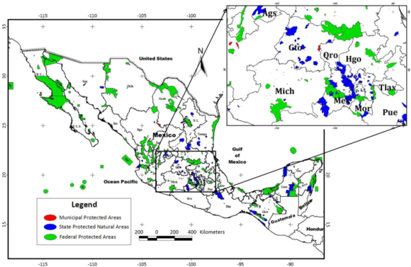
Mexico currently has 177 PNAs (in various categories), and the new additions bring that total to 184.

In addition, preparatory studies are underway to establish two additional biosphere reserves, for the Mexican Caribbean and the Gulf of California (Sea of Cortés).

Mexico's Protected Areas (Gallina, 2012)

Mexico’s Protected Areas (Gallina, 2012)

The Commission of PNAs is working hard to complete formal management plans for every PNA – environmental, social and economic issues. At present, only 97 of the 177 PNAs have such plans in place, with the latest plans published only weeks ago for:

For example, the management program for the whale shark reserve authorizes a maximum of 160 whale-watching boats in an effort to ensure sustainability.

Source of Map:

Sonia Gallina, 2012. “Is Sustainablity Possible in Protected Areas in Mexico? Deer as an Example of a Renewable Resource.” Sustainability 2012, 4 (10), 2366-2376

Related posts:

Mexico has a 2015 population of 121 million people

 Updates to Geo-Mexico  Comments Off on Mexico has a 2015 population of 121 million people
Jul 162015
 

The latest population estimates released by the National Population Council (Conapo) to coincide with World Population Day show that Mexico has a population in mid-2015 of 121,783,280. Of this total, almost 43 million (35.4%) are adolescents, between 10 and 29 years of age.

A spokesperson for Conapo drew attention to the fact that Mexico still needs to do more to overcome gender inequality in fields such as education, salaries and working conditions.

Related posts:

Jun 082015
 

Mexico’s official online database of all the country’s roads and highways has just been updated. As of May 2015, Mexico has a total of 322,859 kilometers of roads and highways.

They are all shown on a map accessed via this web-page. [Link to http://www.imt.mx/micrositios/sistemas-de-informacion-geoespacial/servicios-tecnologicos/red-nacional-de-caminos/ver-datos.html no longer working.]

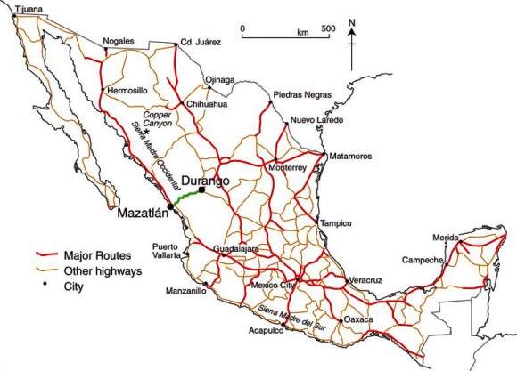
Mexico's major highways (Fig 17-3 of Geo-Mexico, the geography and dynamics of modern Mexico).

Mexico’s major highways, 2009 (Fig 17-3 of Geo-Mexico, the geography and dynamics of modern Mexico). All rights reserved.

Here is a summary of some of the more useful statistics found in the database:

  • 158,180 km of paved highways, including
    • 48,685 km of federal highways,
    • 92,590 km of state highways
    • 9412 km of toll highways
  •  36,139 km of urban roads
  • 118,812 km of rural (unpaved) roads.

The highway network connects 25,844 places, and has links to 39 ferry routes. It also includes 847 toll stations, 3476 bridges and 178 tunnels.

According to the report, Mexico currently has 6480 gas stations. However, this number is expected to increase rapidly in the next few years as competitors enters a market over which PEMEX previously held a monopoly, prior to recent energy reform laws.

If you are planning to drive across Mexico, then the online system at http://ttr.sct.gob.mx/mappir/ will give you routes, distances and estimated times and costs.

Further reading:

Mexico attracting significant inflows of FDI

 Mexico's geography in the Press, Updates to Geo-Mexico  Comments Off on Mexico attracting significant inflows of FDI
May 212015
 

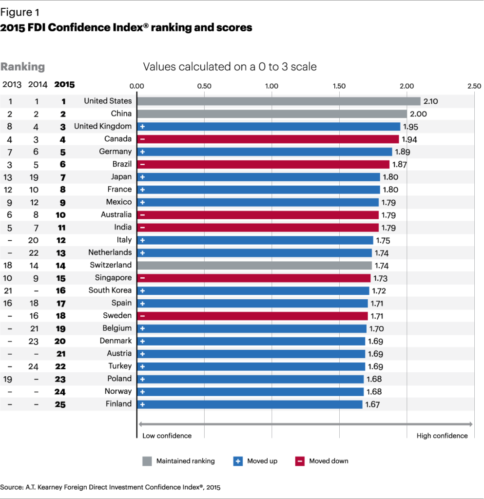
According to the 2015 Direct Foreign Investment Confidence Index of consultancy A.T. Kearney, Mexico is currently the ninth most attractive country worldwide for FDI (Foreign Direct Investment). Mexico has risen 3 places in the rankings since the 2014 Index was released.

The report highlights the improving business climate in Mexico following the implementation of the government’s reform agenda, and says that “investors continue to be drawn to opportunities in many sectors, including manufacturing, energy, and telecoms”.

The top 10 countries in the overall FDI rankings (see graph) are U.S., China, U.K., Canada, Germany, Brazil, Japan, France, Mexico and Australia.

FDI-COnfidence-Index2015

The report says,

Mexico gains three spots to reach 9th, as President Enrique Peña Nieto’s reform agenda continues to improve Mexico’s business climate. Its 2013 FDI levels of $38 billion were an all-time high, with the majority of investment targeted at Mexico’s growing manufacturing sector, including high-value-added electronics. Mexico’s Economy Ministry has reported that flows fell to $22.6 billion in 2014, with inflows of $33.9 billion offset by $11.4 billion in outflows. Significant reforms in the energy sector will occur this year to allow foreign private investment.

As a result of the telecom reforms that targeted Carlos Slim’s América Móvil, which controls 70 percent of the market, customer prices fell nearly 17 percent between February 2013 and January 2015. In response to the policy changes, AT&T made a $5 billion divestment in América Móvil and subsequently acquired Grupo Iusacell SA, Mexico’s third-largest wireless operator, for $1.7 billion. Going forward, these reforms are expected to open up growth opportunities for smaller competitors.

In November 2014, the American chemicals maker PPG Industries acquired paints maker Consorcio Comex for $2.3 billion. This followed the rejection by the Mexican federal competition authority of the sale to Sherwin-Williams for a proposed $2.34 billion on the grounds that it would create unfair market conditions.

According to this recent press report, Mexico’s FDI during the first three months of 2015 totaled $7.573 billion, an all-time record for the first quarter. The figure comes from 1357 separate investments originating from the USA (59.4%), Spain (14.3%), Japan (8.2%), South Korea (4.8%), France (2.9%), and the Netherlands (2.3%), with the remaining 8.1% coming from 48 other nations.

An update on the Human Development Index in Mexico

 Updates to Geo-Mexico  Comments Off on An update on the Human Development Index in Mexico
Mar 192015
 

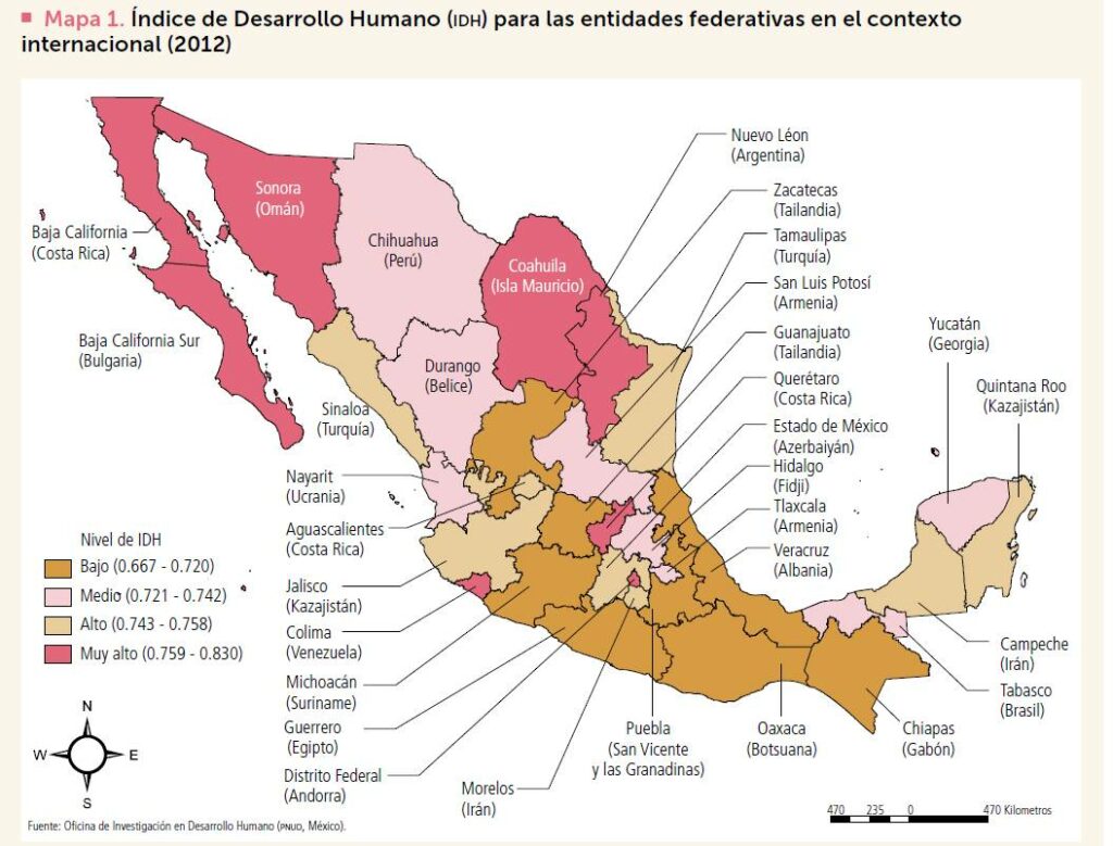
The latest United National Development Program (UNDP) report about the Human Development Index (HDI) in Mexico gives scores and ranks for each state. The full report, in Spanish, entitled “Índice de Desarrollo Humano para las entidades federativas, México 2015: Avance continuo, diferencias persistentes“, is readily available online, and is based on data up to and including 2012.

The HDI is a compound index based on several aspects of three major criteria: health, education and income.

HDI improved between 2008 and 2012 in all states except Baja California Sur. The greatest percentage increases in HDI were in Puebla (where HDI rose 3.7%), Chiapas (3.6%) and Campeche (3.6%). HDI in Baja California Sur fell 0.8%, mainly due to a lower score for education.

HDI in Mexico, with comparison countries for each state

HDI in Mexico, with comparison countries for each state. Click map to enlarge.

The pattern of HDI in Mexico, by state, is shown on the map. The highest HDI values in 2012 were for the Federal District with a score of 0.830, Nuevo León (0.790) and Sonora (0.779). At the other end of the spectrum, Chiapas had the lowest HDI (0.667), below Guerrero (0.679) and Oaxaca (0.681).

As noted previously on Geo-Mexico, the north-south divide in Mexico persists. In general, northern states, together with the Yucatán Peninsula states (Campeche, Yucatán and Quintana Roo) all have HDI values considered “medium” or higher, while southern Mexico (plus some other states, including Zacatecas, Guanajuato, Michoacán and Veracruz) all have “low” values.

The map includes international comparisons. For example, Oaxaca, one of most deprived states in Mexico, had a level of HDI in 2012 comparable to that of Botswana in Africa, even though that nation’s HDI is actually 38 positions below that of Mexico in the world rankings.

The report highlights the extent of disparities by calculating the number of years it will take each state, at the rates of change experienced from 2008 to 2012 to reach the HDI level of Mexico City. Interestingly, while it will apparently take Chihuahua 200 years to reach the HDI level of Mexico City, it will take Chiapas only 20 years to reach the same point.

The main conclusion that can be drawn is that the overall quality of life continues to improve in Mexico though not at equal rates throughout  the country. Disparities persist and current patterns of public spending have failed to make significant inroads into diminishing these disparities. The UN report considers it a priority to close the development gaps in Mexico, especially in the two southern states of Chiapas and Oaxaca.

Related posts: