Thirty years ago: the 1985 Mexico City earthquakes, a major disaster

 Excerpts from Geo-Mexico  Comments Off on Thirty years ago: the 1985 Mexico City earthquakes, a major disaster
Sep 172015
 

The worst earthquake disaster in modern Mexican history occurred thirty years ago this week. On Thursday 19 September 1985 a magnitude 8.1 earthquake struck at 7:19 a.m. and lasted a full two minutes. It was followed by a 7.5-magnitude earthquake 36 hours later.

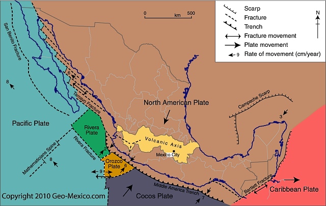
Mexico's position in relation to tectonic plates

Mexico’s position in relation to tectonic plates.Map: Geo-Mexico.com; all rights reserved

These earthquakes resulted from the Cocos Plate (see map) pushing under the North American Plate. While the epicenters were 50 km off Mexico’s Pacific coast, near the Michoacán-Guerrero border, most of the damage occurred 350 km (215 mi) away in Mexico City because the city center’s subsoil, being former lakebed, is very unstable. The clay and silt beneath the city is up to 50 m thick in the area that received most damage. Geologists have likened the effects of the earthquake to the shaking of a bowl of jelly.

Further damage was caused by liquefaction, a process in which water is squeezed rapidly through the pore spaces in soil, dramatically reducing its cohesion. The sediments beneath Mexico City amplified the ground motions during the earthquakes and many buildings were stressed well beyond building code limits.

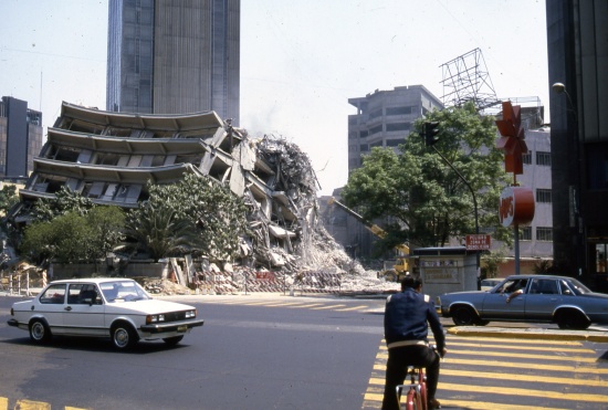
Damage from Mexico City's 1985 earthquake

Damage from Mexico City’s 1985 earthquake. Photo: Tony Burton; all rights reserved

Damage estimates range upward to 10,000 deaths, 50,000 injured and 100,000 homeless. More than 500 buildings collapsed, and a further 600 of the 3000 damaged structures were subsequently razed to the ground. The destruction was concentrated in a relatively small area near the city center and included many public buildings, such as government offices, as well as 11 hospitals and clinics, numerous multi-story apartment blocks, 11 hotels and 10 banks. More than 1600 school classrooms were damaged.

Buildings of between 6 and 15 stories were especially hard hit. The underbelly of the city was exposed; dozens of textile sweatshops were destroyed. The damages revealed many instances of poor construction standards and of poor enforcement of building codes. Well-built high rises such as the Latin American tower, designed to be earthquake-proof, were unscathed.

The total cost to the Mexican economy was estimated to exceed $5 billion, equivalent to 2% of the country’s GDP (Gross Domestic Product).

The disastrous 1985 earthquakes led to much tighter building codes, equal or superior to anywhere in the world, and to the formation of well-trained emergency search and rescue brigades. They also resulted in the establishment of a Seismic Alarm System which provides a 50-second warning for any earthquake measuring over 6.0 on the Richter scale occurring off the coast of Guerrero or Michoacán.

This is an excerpt from chapter 2 of Geo-Mexico: the geography and dynamics of modern Mexico.  Many more details of Mexico’s geology and landforms are analyzed in other parts of the book; take a look using Amazon.com’s Look Inside feature before buying your copy today!

Related posts:

6.9 magnitude earthquake strikes Chiapas and Guatemala (7 July 2014)

 Mexico's geography in the Press  Comments Off on 6.9 magnitude earthquake strikes Chiapas and Guatemala (7 July 2014)
Jul 072014
 

Update (14 July 2014):

Civil Protection groups in Chiapas report that a total of 9,000 homes in that state were damaged by the 6.9 magnitude earthquake that struck the region on 7 July 2014 (see below). Three people lost their lives as a result of the ‘quake: two in Hixtla and the other in Mapastepec.

Minor damages have been reported for various public buildings including the Town Hall in Tapachula, primary schools in Tapachula and Tuxtla Chico, two health care centers in Villacomaltitlán and the municipal market in Escuintla.

While all highways remained open to traffic, minor highway damages were reported on several roads including:

  • the road connecting Unión Juárez to Talquián, Córdova and Chiquihuites
  • the road linking Huixtla to El Jocote

A total of 38 municipalities in Chiapas have now been formally declared “Disaster Areas” which gives them access to funds from the federal Natural Disaster Fund.

The municipalities are Acacoyagua, Acapetahua, Amatenango de la Frontera, Arriaga, Bejucal de Ocampo, Bella Vista, Cacahoatán, Chicomuselo, El Porvenir, Escuintla, Frontera Comalapa, Frontera Hidalgo, Huehuetán, Huixtla, La Grandeza, Mapastepec, Mazapa de Madero, Mazatán, Metapa, Montecristo de Guerrero, Motozintla, Pijijiapan, Siltepec, Suchiate, Tapachula, Tonalá, Tuxtla Chico, Tuzantán, Unión Juárez, Villa Comaltitlán, Altamirano, Ángel Albino Corzo, Comitán de Domínguez, El Parral, La Concordia, Tuxtla Gutiérrez, Villa Corzo and Villaflores.

Original post (7 July 2014):

A strong earthquake has rocked Mexico’s southern state of Chiapas and the neighboring San Marcos region of Guatemala. There are two reported fatalities in Chiapas, while in Guatemala casualties were restricted to a new-born baby, tragically killed by falling debris. About 300 homes in 15 municipalities in Chiapas are reported to have been damaged.

The earthquake, at about 6:30 am local (Chiapas) time, registered 6.9 on the Richter scale, though the US Geological Survey had earlier reported it as magnitude 7.1. The epicenter of the earthquake was 2km north-northeast of Puerto Madero, Chiapas, very close to Tapachula.

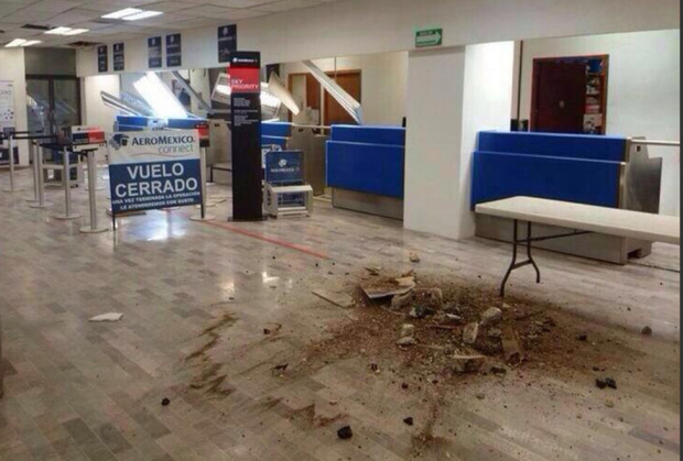
The airport of Tapachula, close to the Mexico-Guatemala border, is now reported to be operating normally, having sustained minor damages (see below) and having been briefly closed for inspection, with no flights allowed to land or take off.

Credit: @TapachulaCentro

Credit: @TapachulaCentro

A sequence of images posted by Mexico City daily Milenio shows some of the damage and devastation caused by the earthquake.

Damage is also reported to many homes in Tapachula, and the town market in Huixtla (north-west of Tapachula) has been partially closed due to structural damage.

We will update this report as more information becomes available.

Related posts:


Apr 182014
 

A major earthquake struck southern Mexico at 7:27 local time on Friday 18 April 2014. The effects of the earthquake, which had its epicenter in Guerrero, were felt at least as far away as Mexico City. Authorities in the states affected, which include Guerrero, Morelos, México, Puebla, Oaxaca, Querétaro, Veracruz, Jalisco, Michoacán, Tlaxcala, Guanajuato, Hidalgo, Colima and the Federal District, have reported only minor damage, and no loss of life.

The preliminary report from Mexico’s National Seismological Institute says that the earthquake had a magnitude of 7.0, with an epicenter 31 kilometers northwest of Tecpan in Guerrero, and occurred at 7:27 a.m. local time. The earthquake occurred at a depth of 10 kilometers.

Initial reports from the U.S. Geological Survey (including a map) are that the earthquake was 7.5 magnitude, and at a depth of around 48 kilometers (30 miles). The USGS has since downgraded the magnitude to 7.2.

First hand reports from Mexico City say that power went off in several areas in the north of the city, and that cell phone communications were also down in some areas. The Federal Electricity Commission reported 6 hours after the earthquake that power had been restored to 98% of the 1.2 million people affected in the Mexico City Metropolitan Area. Some windows have been shattered, and there are a handful of reports of minor structural damage, including 15 walls that collapsed and 48 buildings that suffered some damage. The city was quieter than normal because of the Easter holidays, during which many city dwellers take vacations at the beach.

The most serious damage in Mexico City appears to have been in the Morelos residential complex in colonia Doctores, where the residents of two of the 14-story buildings have apparently been evacuated following reports of cracks in walls and passageways, and the separation of some stairways. Following a formal building inspection, one of the buildings will not be reoccupied prior to remedial work being carried out.

Residents of Mexico City received 65 seconds warning via Mexico’s advanced Seismic Alert system (Sistema de Alerta Sísmica), which functioned precisely as it was designed to. There were more than twenty aftershocks in the five hours after the initial earthquake, the largest of which was magnitude 4.8.

George Dunn in Puerto Vallarta (see comments) reports that buildings at the Bay View Grand were evacuated. “but all is well”. Many tourists in Puerto Vallarta and Acapulco left their hotel rooms temporarily during the quake which lasted about one minute.

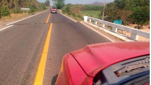
In Guerrero, it is reported that the highway between Acapulco and Ixtapa-Zihuatanejo is temporarily closed to traffic while inspections are carried out of a bridge near Tecpan, where the road shows a marked displacement (see image), and the rubble from several small landslides is removed. [Update: 9 May 2014: A second earthquake of magnitude 6.4 on 8 May has caused the bridge to collapse completely. The bridge, known as “El Cuajilote” is located at km 111 of the federal highway between Acapulco and Zihuatanejo.]

road-fracture

Later on Friday, officials of Guerrero state acknowledged that many public buildings in the state suffered damage from the earthquake. In Petatlán, near the epicenter, at least 100 homes were damaged. In the state capital of Chilpancingo, several walls collapsed, at least three homes and the tower of the Santa María de la Asunción cathedral suffered some damage.

As a precaution, the main (tourist) dock in Zihuatanejo has been closed, pending a formal inspection, but is expected to be back in operation within the next day or two.

Curious coincidence: The earthquake came exactly 108 years to the day after the Great San Francisco Earthquake of 1906.

We will continue to update this post periodically over the next few days to reflect any significant changes.

Related posts:

How has the movement of tectonic plates affected Mexico?

 Excerpts from Geo-Mexico  Comments Off on How has the movement of tectonic plates affected Mexico?
Apr 122012
 

In a previous post, we identified the tectonic plates that affect Mexico. In this piece, we look at some of the major impacts of Mexico lying on or close to so many different plates.

To the east of Mexico, in the last 100 million years, outward expansion from the Mid-Atlantic Ridge (a divergent boundary) first pushed South America ever further apart from Africa, and then (slightly more recently) forced the North American plate (and Mexico) away from Eurasia. The Atlantic Ocean continues to widen, expanding the separation between the New World and the Old World, by about 2.5 cm (1 in) each year.

Mexico's position in relation to tectonic plates

Mexico's position in relation to tectonic plates.Map: Geo-Mexico.com; all rights reserved

Meanwhile, to the west of Mexico, an analogous situation is occurring in the Pacific Ocean, where the Cocos plate is being forced eastwards away from the massive Pacific plate, again as a result of mid-ocean activity. The Cocos plate is effectively caught in a gigantic vice, its western edge being forced ever further eastwards while its leading eastern edge smacks into the North American plate.

The junction between the Cocos and North American plates is a classic example of a convergent plate boundary. The collision zone is marked by a deep ocean trench, variously known as the Middle America trench or the Acapulco trench. Off the coast of Chiapas, this trench is a staggering 6662 m (21,857 ft) deep. The trench is formed where the Cocos plate is forced to dive beneath the North American plate.

As the Cocos plate is subducted, its leading edge fractures, breaks and is partly re-melted into the surrounding mantle. Any cracks in the overlying North American plate are exploited by the molten magma, which is under immense pressure, and as the magma is forced to the surface, volcanoes form. The movement of the plates also gives rise to earthquakes. The depth of these earthquakes will vary with distance from the deep ocean trench. Those close to the trench will be relatively shallow, whereas those occurring further away from the trench (where the subducting plate is deeper) will have deeper points of origin.

As the plates move together, sediments, washed by erosion from the continent, collect in the continental shallows before being crushed upwards into fold mountains as the plates continue to come together. A line of fold mountains stretches almost continuously along the west coast of the Americas from the Rocky Mountains in Canada past the Western and Southern Sierra Madres in Mexico to the Andes in South America. Almost all Mexico’s major mountain ranges—including the Western Sierra Madre, the Eastern Sierra Madre and the Southern Sierra Madre—formed as a result of these processes during the Mesozoic Era, from 245 to 65 million years ago.

However, no sooner had they formed than another momentous event shook Mexico. About 65 million years ago, a giant iridium-rich asteroid slammed into the Gulf of Mexico, close to the Yucatán Peninsula, causing the Chicxulub Crater, and probably hastening the demise of the dinosaurs. An estimated 200,000 cubic km of crust was pulverized; most of it was thrown into the air. The resulting dust cloud is thought to have contributed to the extinction of up to 50% of all the species then on Earth. Not only did this event have an enormous impact on all life forms on Earth, it also left a legacy in the Yucatán. The impact crater is about 200 km (125 mi) across. Its outer edge is marked by a ring of sinkholes (locally known as cenotes) and springs where the fractured crust provided easy access to ground water. These locations include the ria (drowned river valley) of Celestún (now a UNESCO Biosphere Reserve), where fresh water springs mingle with salt water to create an especially rich habitat for birdlife.

In the 65 million years since the asteroid impact (the Cenozoic period), the remainder of Mexico has been formed, including many of the plateaus and plains, and the noteworthy Volcanic Axis, which owes its origin to still-on-going tectonic activity at the junction of the North American and Cocos plates.

Related posts:

Two major earthquakes jolted western Mexico (11/12 April 2012)

 Other  Comments Off on Two major earthquakes jolted western Mexico (11/12 April 2012)
Apr 112012
 

Two major earthquakes in two days! Fortunately, they struck in different sections along Mexico’s west coast, meaning that few if any people were shaken by both. The first earthquake struck in Michoacán on 11 April, and was felt over a wide area of central Mexico. This earthquake registered 6.5 on the Richter scale (preliminary estimates had originally suggested it was magnitude 7.0).

The La Mira earthquake, Michoacán (source: USGS]:

  • Time: Wednesday, April 11, 2012 at 17:55 local time
  • Location 18.272N, 102.732̊W
  • Depth 20 km (12.4 miles)
  • The epicenter was about 61 km (38 miles) NW from Lázaro Cárdenas, Michoacán, 130 km (80 miles) SSW from Uruapan, Michoacán, and 143 km (88 miles) NW of Zihuatanejo, Guerrero. This placed it relatively close to the community of La Mira in the state of Michoacán.
  • Only minor damage was reported following this earthquake, despite its magnitude.

The Santa Isabel earthquake

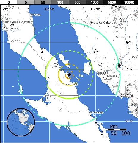
The following day (12.15 am local time on 12 April), an even larger earthquake, magnitude 6.9, hit further north in Mexico, close to the coast of Baja California. Its epicenter was 183 kilometers (113 miles) from Santa Rosalia (Baja California Sur) and 214 kilometers (132 miles) from Hermosillo (Sonora). This meant that its effects were greatest in areas where population is very sparse (see map), and fortunately, once again, there were no reports of any loss of life or major damage.

Few people live in the region struck by the Santa Isabel earthquake.

Few people live in the region struck by the Santa Isabel earthquake.Credit: USGS

These two earthquakes come less than a month after the major magnitude 7.4 earthquake that hit the states of Oaxaca and Guerrero on 20 March 2012. This ‘quake caused significant damage – and was followed by dozens of aftershocks, including one on 2 April that registered 6.0 on the Richter scale.

Now that several parts of this junction of tectonic plates have shifted in quick succession, everyone hopes that these earthquakes will have relieved enough pent-up pressure, and re-adjusted the plates  sufficiently, to prevent further earthquakes in the region in the near future.

Related posts:

Which tectonic plates affect Mexico?

 Excerpts from Geo-Mexico  Comments Off on Which tectonic plates affect Mexico?
Apr 022012
 

The theory of plate tectonics suggests that the earth’s crust or lithosphere is from 5 to 65 km (3 to 40 mi) thick and divided into about a dozen large tectonic plates, tabular blocks that drift across the Earth in different directions and at various speeds (up to a few centimeters or inches per year), probably as a result of thermal convection currents in the Earth’s molten mantle. Most plates consist of a combination of both ocean floor and continent, though some are entirely ocean floor.

Each tectonic plate is moving relative to other plates. The movements are not independent because the plates smash into and scrape against one another. Areas in the center of tectonic plates, far from the boundaries, have relatively little seismic activity, but the boundaries between plates are seismically very active, creating earthquakes and volcanoes. The level of seismic activity depends on the relative speed and direction of the plates at the boundary.

There are three distinct kinds of boundaries between plates. At divergent boundaries, along mid-ocean ridges, plates are being steadily pushed apart, with new crust being added by volcanic activity to the rear of each plate as it moves. At convergent boundaries, plates collide and parts of the plates either buckle or fracture or are subducted back down into the molten mantle. The third kind of boundary is where plates are neither created nor destroyed but are moving side by side. The resulting friction as they rub against each other can produce large earthquakes.

Almost all of Mexico sits atop the south-west corner of the massive North American plate (see map). Immediately to the south is the much smaller Caribbean plate. The North American plate extends westwards from the Mid-Atlantic Ridge, which runs through Iceland and down the middle of the Atlantic Ocean, to the western edge of North America. In a north-south direction, it extends from close to the North Pole as far south as the Caribbean.

Mexico's position in relation to tectonic plates

Mexico's position in relation to tectonic plates.Map: Geo-Mexico.com; all rights reserved

While most of Mexico rests on the North American plate, it is also influenced by several other plates.

The Baja California Peninsula is on the gigantic Pacific plate, which is moving northwest and under the North American plate. The intersection of these plates under the Gulf of California causes parallel faults which are part of the famous San Andreas Fault system. Thus, the Gulf of California is an area of heavy seismic activity.

The small Rivera plate, between Puerto Vallarta and the southern tip of Baja California, is moving in a southeasterly direction and rubbing against the Pacific plate; it, too, is moving under the North American plate.

The Cocos plate and tiny Orozco plate are ocean crust plates located off the south coast of Mexico. The collision of the Cocos plate and the North American plate has had several far-reaching consequences, including both the disastrous 1985 earthquakes that caused such severe loss of life and damage in Mexico City and the much more recent 2012 earthquake that, fortunately, was far less destructive.

Related posts:

April earthquake leads to Mexico-USA talks over water-sharing

 Mexico's geography in the Press  Comments Off on April earthquake leads to Mexico-USA talks over water-sharing
Sep 142010
 

In April 2010, a large earthquake rattled the Mexicali area, causing significant damage. It was so powerful that it even moved the southern part of California! The magnitude 7.2 earthquake damaged the irrigation infrastructure used by Mexican farmers on land along the lower Colorado River and in the Colorado River delta region.

Mexico and US officials are reported to be discussing the Colorado water-sharing agreement, given the damage done to irrigation facilities following the April earthquake (The OOSKA News Weekly Water Report for Latin America and the Caribbean, 18 August 2010).

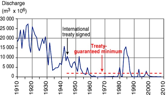
River Colorado discharge entering Mexico, 1910-2010

River Colorado discharge entering Mexico, 1910-2010. Figure 6.5 of Geo-Mexico; all rights reserved

As we noted in an earlier post, a 1944 treaty guaranteed that at least 1750 million cubic meters of water (see graph) would enter Mexico each year along the Colorado River via the Morelos diversionary dam in the Mexicali Valley. The damaged infrastructure means that Mexico is unable to use effectively all of its annual allocation of water from the Colorado. Urgent repairs are underway on pumps, pipelines and irrigation channels, particularly those in the Mexicali region.

Meanwhile, Mexican officials have asked their US counterparts if it is possible to store some of Mexico’s 2010 allocation of water in the Lake Mead reservoir near Las Vegas, until repairs to irrigation systems have been completed.

Earthquakes in Mexico are discussed in detail in chapter 2 of Geo-Mexico: the geography and dynamics of modern Mexico. Mexico’s water resources and water-related issues are the subject of chapters 6 and 7. Ask your library to buy a copy of this handy reference guide to all aspects of Mexico’s geography today! Better yet, order your own copy…

Baja earthquake moved part of California

 Maps, Mexico's geography in the Press  Comments Off on Baja earthquake moved part of California
Jun 242010
 

The 4/4/2010 (Easter Sunday) earthquake centered in Baja California really did not only shake the earth but also move it. What is even more amazing is that this may be one of the best documented examples of an earthquake in one country moving parts of a neighboring country.

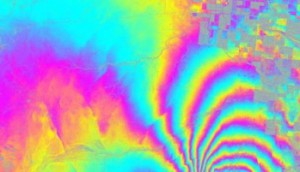
UAVSAR interferogram of Calexico region

UAVSAR interferogram of Calexico region. Credit: NASA/JPL

NASA has released data showing that the 4/4/2010 earthquake in Baja California moved the border city of Calexico in California. According to NASA’s analysis of radar data from research flights, the April earthquake moved the Calexico region as much as 0.8 meters (2.5 feet) towards the south.

Further south, in Baja California, some parts of the ground moved up to 3 meters (10 feet).

For a full explanation of the image, which shows an area about 20km east-west, by 15 km north-south, please refer to the original article.

Earlier post on 4/4/2010 earthquake: 7.2 magnitude earthquake strikes Baja California (4 April 2010)

Other cities have also been moved by earthquakes. For instance, in the magnitude-8.8 Chilean earthquake of 27 February 2010 , the city of Concepción in Chile was displaced a whopping 3 meters (10 feet) west of its original position.

Apr 042010
 

Initial reports of the earthquake, which struck at at 15:40 Pacific time, are that the epicenter was about 160 kilometers south-east of Tijuana and that the earthquake occurred at a depth of about 10 kilometers. The shaking was felt in downtown Los Angeles.

Press  reports confirm two fatalities and 100 people injured, as well as considerable damage to some buildings in Mexicali. More than 5000 homes in the rural areas south of Mexicali have been badly damaged. About 25,000 people have received emergency shelter and food and other assistance.

Press reports (latest at the top):

Millions in California, Arizona feel 7.2 quake (AP)

Telegraph.co.uk article about the earthquake

Damage reported from Mexicali – LA Times blog

USGS data on earthquake

USGS – Community earthquake intensity map