In January 2007, the world’s longest underground river was reported from Mexico’s Yucatán Peninsula. [Prior to that date, the honor was held by the Puerto Princesa Subterranean River in the Philippines]
The Sac Actun (“White Cave”) river system in the Yucatán Peninsula wanders for 153 km (95 miles) through a maze of underground limestone caves. It took British diver Stephen Bogaerts and his German colleague Robbie Schmittner four years to explore the caverns using underwater scooters and specially rigged gas cylinders, before they finally discovered a connection between the Yucatán region’s then second- and third-longest cave systems, known respectively as Sac Actun and Nohoch Nah Chich (“Giant Birdcage”). Following the discovery of a link, the entire system is now known as Sac Actun. The system has a total surveyed length (including dry caves) of 319 kilometers (198 mi), making it the longest cave system in Mexico, and the second longest worldwide. [The longest is the dry Mammoth Cave System, Kentucky, USA, which measures 643.7 km (400 mi) in length].
Sac-Actun cave system
Vying with Sac Actun for the title of longest surveyed underwater cave system is the nearby Sistema Ox Bel Ha (“Three Paths of Water”), also in the Tulum municipality of Quintana Roo. As of August 2013, surveys had measured 256.7 kilometers (159.5 mi) of underwater passages.
The underground passages and caverns of the Yucatán Peninsula have been a favored site for cave explorers for decades. Formal mapping of the systems has taken more than 20 years of painstaking work. Access to the systems is via the hundreds of sinkholes (cenotes) that litter the surface of the Peninsula. The Sac Actun system alone includes more than 150 cenotes.
Water management was critical to the Maya as they developed their advanced civilization in this area, a region with very limited surface freshwater. Many of the cenotes in the Yucatán Peninsula have archaeological importance and were utilized by the Maya for ceremonies. Perhaps the best-known (and most visited) cenote is the Sacred Cenote (cenote sagrado) at the archaeological site of Chichen Itza.
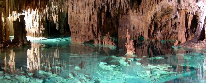
The caverns of the Yucatán Peninsula were formed as a result of the slow solution of limestone over thousands of years by percolating, slightly acidic, rainwater. In some cases, cave formations, such as stalactites and stalagmites, have later grown in the caves, formed drip-by-drip from the slow deposition of calcium carbonate from calcium-saturated ground water.
Because the average elevation of the Yucatán Peninsula is only a few meters above sea level, the water in many of the caves is “layered”, with a lens of freshwater overlying a layer of salt water. Rainwater that soaks into the ground becomes ground water, which then moves slowly along the watertable to eventually reach the ocean.
Cave researchers are worried that tourist developments in the Yucatán Peninsula will have adverse impacts on underground water systems, both in terms of water quantity (because of the amounts of fresh water extracted for domestic and tourist use) and in terms of water quality, because even point sources of water pollution (such as excess fertilizers from a golf course) could contaminate underground water supplies over a wide area.
Want to read more?
- World’s longest caves
- Quintana Roo Speleological Survey
- World’s longest underwater caves
- World’s longest underground river discovered in Mexico (National Geographic)
- Divers discover huge underground river (Guardian)
Related posts
- The geography of Mexico’s caves
- Deepest water-filled sinkhole in the world: El Zacatón, Tamaulipas
- The world’s largest crystals grow in caves in Chihuahua, Mexico
- Mexico’s geomorphosites: El Sótano de las Golondrinas (Cave of the Swallows)
- Geotourism and geomorphosites in Mexico
- Geotourism in Mexico: García Caves (Grutas de García) in Nuevo León
Sorry, the comment form is closed at this time.