A new museum 40 kilometers northwest of the Yucatán state capital – Mérida – is expected to open later this year to explain the nearby Chicxulub Crater, created by an asteroid impact 65 million years ago, and believed to be responsible for the demise of the dinosaurs.
Is mass tourism a form of colonialism or imperialism? This, essentially, is the question thoughtfully considered by Denise Fay Brown of the University of Calgary in her article, “Tourists as colonizers in Quintana Roo, Mexico”, published in the Summer 2014 issue of The Canadian Geographer.
Brown draws on decades of personal ethnographic fieldwork related to Maya spatiality and sociospatial organization in the Yucatec Maya zone, Quintana Roo. She argues that tourists, albeit unwittingly, are increasingly able (financially and in terms of ready access) to engage with “exotic landscapes”, but that their presence in such landscapes “results in the reterritorialization of the destinations that mimics the colonial enterprise.” In particular, in Quintana Roo, she claims that “an important segment of the landscape of the Yucatec Maya people has been appropriated and reterritorialized.” (How many tourists visiting Cancún and the so-called Riviera Maya region realize that this coast was largely terra incognita fifty years ago?)
One of the classic indicators of colonialism is spatial appropriation. Maya infighting aside, the earliest attempts at spatial appropriation in Quintana Roo were by Spain during early colonial times in the early sixteenth century. Even after independence in 1821, the Yucatán Peninsula resisted integration with the rest of the (new) nation. This resistance was not only due to cultural differences, but also to the Yucatán Peninsula’s location in the periphery, a long way from the seat of power in Mexico City. Indeed, despite the massive program of railway building that helped consolidate other parts of Mexico during the late nineteenth century, a rail link from central Mexico to the Yucatán Peninsula was only finally put in place in the 1950s.
Brown makes the case that the assault on Maya territory has continued into recent times, even if, “Today, it is not the conventional notion of nation state colonialism but a much more subtle invasion brought about by the ability of tourists from richer nations to travel south.”
She makes a strong argument that the growth of tourism in the Yucatán Peninsula has been “predatory” and that foreign tourists, especially those engaging in mass tourism, are, in fact, unwitting colonizers.
Brown concludes that, “The case of Quintana Roo, Mexico illustrates how the tourist can be seen as a pawn in a larger political project. Exposure of this predatory nature of tourism reveals processes that have implications for other Native regions of the Americas and beyond that are suffering similar “invasions.””
Thinking about the extent to which tourism is just one more manifestation of colonialism adds a whole new dimension to traditional tourism studies looking at economic, social and environmental advantages and disadvantages. Brown’s argument is persuasive, and, clearly, the political and cultural impacts of tourism deserve equal consideration.
Reference:
- Denise Fay Brown. 2014. “Tourists as colonizers in Quintana Roo, Mexico”, The Canadian Geographer, vol 57, #2, Summer 2014, pp 186-205.
Related posts:
- The resort city of Cancún continues to grow (Apr 2014)
- The growth of Cancún, Mexico leading tourist resort (Feb 2010)
- Beach erosion in the tourist resort of Cancún, Mexico (Dec 2010)
- Ecological footprints, marine conservation and Cancun’s underwater sculpture park (Feb 2013)
- Artificial reef near Cancún doubles as an underwater art gallery (Mar 2012)
World’s longest underground river flows deep beneath the Yucatán Peninsula
In January 2007, the world’s longest underground river was reported from Mexico’s Yucatán Peninsula. [Prior to that date, the honor was held by the Puerto Princesa Subterranean River in the Philippines]
The Sac Actun (“White Cave”) river system in the Yucatán Peninsula wanders for 153 km (95 miles) through a maze of underground limestone caves. It took British diver Stephen Bogaerts and his German colleague Robbie Schmittner four years to explore the caverns using underwater scooters and specially rigged gas cylinders, before they finally discovered a connection between the Yucatán region’s then second- and third-longest cave systems, known respectively as Sac Actun and Nohoch Nah Chich (“Giant Birdcage”). Following the discovery of a link, the entire system is now known as Sac Actun. The system has a total surveyed length (including dry caves) of 319 kilometers (198 mi), making it the longest cave system in Mexico, and the second longest worldwide. [The longest is the dry Mammoth Cave System, Kentucky, USA, which measures 643.7 km (400 mi) in length].
Vying with Sac Actun for the title of longest surveyed underwater cave system is the nearby Sistema Ox Bel Ha (“Three Paths of Water”), also in the Tulum municipality of Quintana Roo. As of August 2013, surveys had measured 256.7 kilometers (159.5 mi) of underwater passages.
The underground passages and caverns of the Yucatán Peninsula have been a favored site for cave explorers for decades. Formal mapping of the systems has taken more than 20 years of painstaking work. Access to the systems is via the hundreds of sinkholes (cenotes) that litter the surface of the Peninsula. The Sac Actun system alone includes more than 150 cenotes.
Water management was critical to the Maya as they developed their advanced civilization in this area, a region with very limited surface freshwater. Many of the cenotes in the Yucatán Peninsula have archaeological importance and were utilized by the Maya for ceremonies. Perhaps the best-known (and most visited) cenote is the Sacred Cenote (cenote sagrado) at the archaeological site of Chichen Itza.
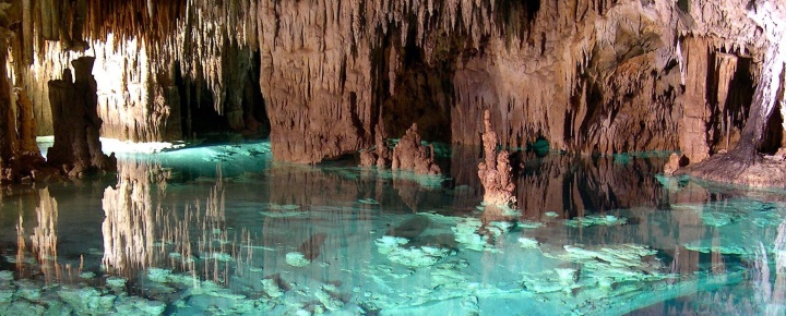
The caverns of the Yucatán Peninsula were formed as a result of the slow solution of limestone over thousands of years by percolating, slightly acidic, rainwater. In some cases, cave formations, such as stalactites and stalagmites, have later grown in the caves, formed drip-by-drip from the slow deposition of calcium carbonate from calcium-saturated ground water.
Because the average elevation of the Yucatán Peninsula is only a few meters above sea level, the water in many of the caves is “layered”, with a lens of freshwater overlying a layer of salt water. Rainwater that soaks into the ground becomes ground water, which then moves slowly along the watertable to eventually reach the ocean.
Cave researchers are worried that tourist developments in the Yucatán Peninsula will have adverse impacts on underground water systems, both in terms of water quantity (because of the amounts of fresh water extracted for domestic and tourist use) and in terms of water quality, because even point sources of water pollution (such as excess fertilizers from a golf course) could contaminate underground water supplies over a wide area.
Want to read more?
- World’s longest caves
- Quintana Roo Speleological Survey
- World’s longest underwater caves
- World’s longest underground river discovered in Mexico (National Geographic)
- Divers discover huge underground river (Guardian)
Related posts
- The geography of Mexico’s caves
- Deepest water-filled sinkhole in the world: El Zacatón, Tamaulipas
- The world’s largest crystals grow in caves in Chihuahua, Mexico
- Mexico’s geomorphosites: El Sótano de las Golondrinas (Cave of the Swallows)
- Geotourism and geomorphosites in Mexico
- Geotourism in Mexico: García Caves (Grutas de García) in Nuevo León
The Tikul Plantation cacao project near Mérida
By way of contrast to the much-criticized, and now collapsed, Maya Biosana chocolate project, the Tikul Plantation, near Merida (Yucatán), is a well thought out cacao-growing project, with an educational component, being carried out by people who have decades of real experience with cacao. (Follow the link for a series of photos which gives a good idea of what is involved). Among the principles adapted by the Tikul project is biodynamic farming, which in this case means that “grafting is carried out when the moon is waxing and we harvest the pods when the moon is waning”.
 That cacao plantation, begun in 2008 by Belgian firm Belcolade, already has 10 hectares of land planted with 10,000 cacao trees (planting density of 1000 cacao trees/hectare). In addition, “20 more hectares have been cleared and cedar and mahogany trees, amongst others, have been planted”. The developers of that project already have the 20,000 cacao trees to be grafted to complete the planting of this area. The shade plants that have been planted include 2000 yucca (cassava), 4000 banana plants, 10,000 cedar trees and 5000 mahogany trees. This means an average planting distance of “a cacao tree every 3 meters, a cedar tree every 6 meters and a mahogany tree every 12 meters”.
Belcolade produces high quality Belgian chocolate for distribution to over 100 countries. “Belcolade, the Real Belgian Chocolate, is produced solely in Belgium following a long tradition of craftsmanship, quality and refinement. It is made from carefully selected cocoa beans using production processes that have been perfected over time, thus assuring that Belcolade’s exquisite taste is in line with consumers’ expectations.”
Visitors to the Tikul Plantation are introduced to the importance of cacao to the Mayan culture in the “Cacao EcoMuseum” near the Plantation’s entrance.
The Cacao Ecomuseum is not without its critics. According to an article in the Yucatán Times, Becolade never received the appropriate permits from the National Institute for Anthropology and History (INAH) to build a structure in a protected zone. The article alleges that construction was only possible because certain INAH officials acted corruptly.
Meanwhile another enterprise Choco-Story, with local partners, (and which has no connection to Belcolade as we incorrectly claimed in an earlier version of this post) has come under heavy fire in the press in recent months because it also started to build Chocolate Museums on the archaeological zones of Chichen Itza and Uxmal. Construction of both has now been halted, with INAH officials ordering that the partially-completed structures be demolished. The latest reports are that the conflict at Uxmal has been resolved and that the Choco-Story museum at that site will open sometime next year.
Related posts:
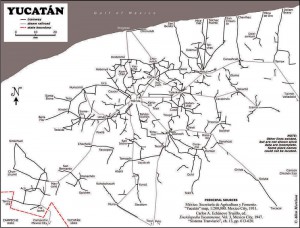
About 1900 one of the densest railroad networks on earth was operating in the Yucatán Peninsula. Between 1870 and 1920 the area experienced an economic boom based on the production of twine from sisal (oro verde or green gold). The numerous plantations in the area needed a way to move the sisal from the fields to processing centers and from there to ports for export. The plantation owners built a very extensive (4500 km) system of narrow gauge railroad system to move sisal as well as sugar and corn.

Map of Yucatan's railways. Copyright Allen Morrison. Reproduced by kind permission (see link to original map near end of this post). Click map for larger version.
The tracks stretched up to 100 km in all directions from Yucatán’s capital, Mérida. Rolling stock and complete sections of track with steel ties were imported mostly from Europe but also from the USA. The small trains were powered by mules, steam engines, electric batteries, and later by gasoline motors. There was no standard design. Several different gauges were in use ranging from 400 to 930 mm (15.7 to 36.6 in).
Foreign competition, the Mexican Revolution, and synthetic fibers brought an end to the sisal boom. Many of the plantations closed in 1930s. Soon small entrepreneurs were providing rail passenger services between the scores of towns in the area. Many families used the small sisal hauling cars as personal transport, powered by a horse or mule. This was far more efficient than animal drawn carts on the rough dirt roads, but required occasional de-railing to allow those going in the opposite direction to pass. Some of the Yucatán’s narrow gauge lines have survived into the 21st century, and some of the former sisal haciendas have reopened as luxury hotels for tourists.
Acknowledgments: Grateful thanks to Allen Morrison, who generously allowed us permission to reproduce his excellent map of Yucatán railways.
Mexico’s transportation systems are the subject of chapter 17 of Geo-Mexico: the geography and dynamics of modern Mexico. Buy your copy today!
Yucatán’s main line railway was not linked to the rest of Mexico until about 1950.
On January 1, 1846, the Criollo leaders in Merida declared independence as the Republic of the Yucatán for the third time. In 1847, the Caste War broke out when the Mayas rebelled against the Criollo upper class that controlled the Yucatán Republic. They drove most of the Criollos out of the Peninsula except for the those behind the walls surrounding Mérida and Campeche City.
With their back to the wall, the Yucatan Republic offered sovereignty over to Yucatán to either USA or Britain or Spain, whichever was first to effectively end the Maya revolt. In a desperate effort to put down the rebellion, the Yucatán Criollos agreed on 17 August 1848 to re-unite with Mexico if the Mexican army would put down the Maya rebellion. With fresh Mexican troops, they retook control over northwestern portion of the Peninsula. However, Mayas maintained control of the southeast for the rest of the 19th century and beyond. Skirmishes continued on and off for more than 70 years. Maya independent control of some parts of the southeastern Yucatán Peninsula did not end until after the Mexican Revolution.
See also:
The Republic of the Yucatán
After independence in 1821, the Federated Republic of Yucatán joined the Mexican federation in May 1823. The new republic comprised the whole Yucatan Peninsula including what is now the states of Campeche and Quintana Roo. It maintained a degree of autonomy in the Mexican federation.
In the mid 1830s President Santa Anna imposed a centrally controlled dictatorship, which imposed significant control over Yucatán. This lead to a rebellion in 1838 seeking Yucatán independence. Negotiations with Santa Anna to give Yucatán more autonomy within the Mexican Republic stumbled.
In 1840 the Yucatán declared full independence as the Republic of the Yucatán. At the time, Santa Anna was preoccupied with rebellions in northern Mexico, but he did blockade Yucatán ports. At the time, there were no land routes between the Yucatán and either Mexico or Central America. In 1843 Mexico sent troops to Yucatán to put down the rebellion. They failed, but the blockade was successful. The young Republic had no navy and no way to trade because its ports were successfully blockaded. It agreed in December 1843 to rejoin Mexico when given assurances of self-rule.
But the assurances of self-rule were not upheld and the Yucatán declared independence again on January 1, 1846. When the Mexican–American War broke out later that year, Yucatán declared neutrality. While Mexico had its hands full fighting the USA, the Yucatán had its own problems. In 1847 the Mayas initiated the Caste War by rebelling against the Hispanic (Criollo) (creole) upper class that controlled the Yucatán Republic.
With its back to the wall in early 1848, the Yucatán Republic offered sovereignty over Yucatán to either USA or Britain or Spain, whichever was first to effectively end the Maya revolt. The USA invoked the Monroe Doctrine to keep the other two out and seriously considered the proposal, but in the end did not accept it.
In a desperate effort to put down the rebellion, the Yucatán Criollos agreed on 17 August 1848 to re-unite with Mexico if the Mexican army would put down the Maya rebellion. Thus the on and off life of the Republic of the Yucatán came to an end. The peninsula remained relatively separate from the rest of Mexico. The first railroad link was established in the 1950s (see earlier post about the first map on a Mexican postage stamp) and the first highway in the 1960s.
See also:
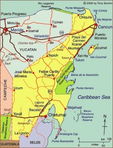
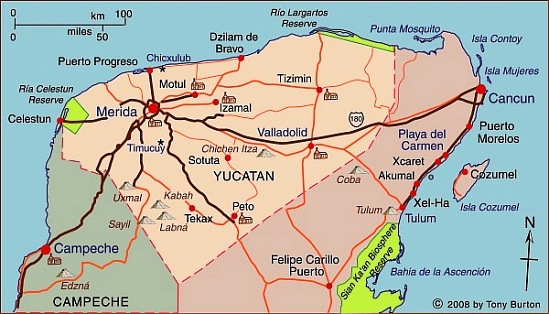
Yucatán state (see the map below) has an area of 39,612 square kilometers and a population of 1,945,840 (2010 estimate). Its distinctive landscapes include coastal rias (drowned river valleys, such as Celestún) and tropical karst (limestone scenery). The state’s capital city is Mérida, the “white city” (2009 population: 955,000).
The state was an important sisal-producing area during the 19th century. Sisal was exported all over the world through the port of Sisal [see comments], later surpassed as a port by Progreso.
The state has numerous important Mayan sites, including Uxmal and Chichen Itza. These sites have led to cultural tourism becoming very important to the state’s economy. Several cities, including Mérida and Izamal, have outstanding examples of colonial architecture. Several former sisal haciendas have been turned into luxurious hotels.
Several attempts have been made in recent decades to link the Yucatán Peninsula to the US Gulf coast by vehicle ferry, but none has yet succeeded. Such a route would save several days of driving time and would be a huge boost to overland tourism in the state, since many of its potential cultural and eco-tourist attractions are not very easy to reach by public transport.


